WEEKEND WEATHER FORECAST

#weather #paweather #wx #pawx #philadelphia

Update Sat 3/11 8:54 PM — Sunday’s forecast below is unchanged. High temp 46.5° sd 1.4°


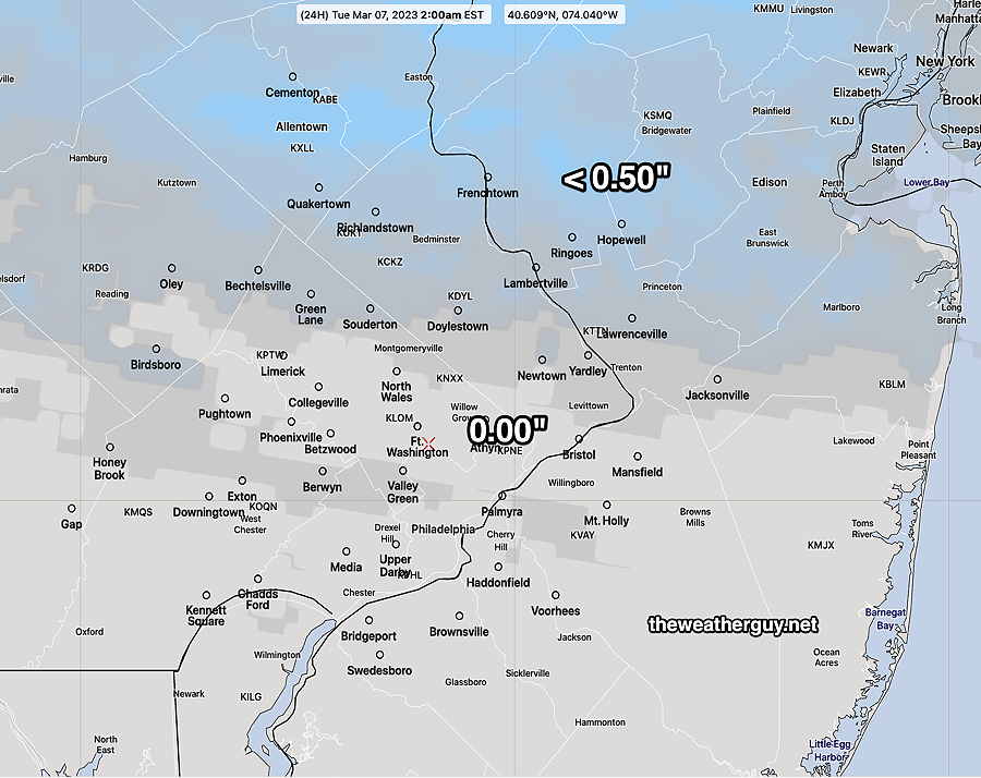
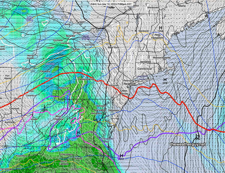
Update Sat 03/11 @ 10:08 AM — We had the wet snow here before 8AM. The balance of precip will be light rain. There’s a wide range of model opinion regarding clearing today.

After reviewing the models, it appears that a considerable amount of low cloudiness will remain, but there’s a chance of some short-lived breaks of sun in some areas this afternoon. Some additional showers possible.

The HRRR shows another band of light showers moving through about 3-5 PM or so—

This morning’s 12z HRRR shows clouds (black/grey) and showers at 4 PM today. (Click on image for a larger view.)

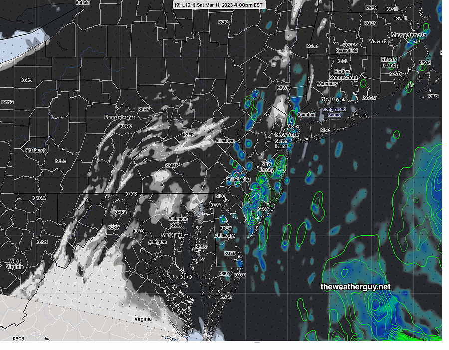
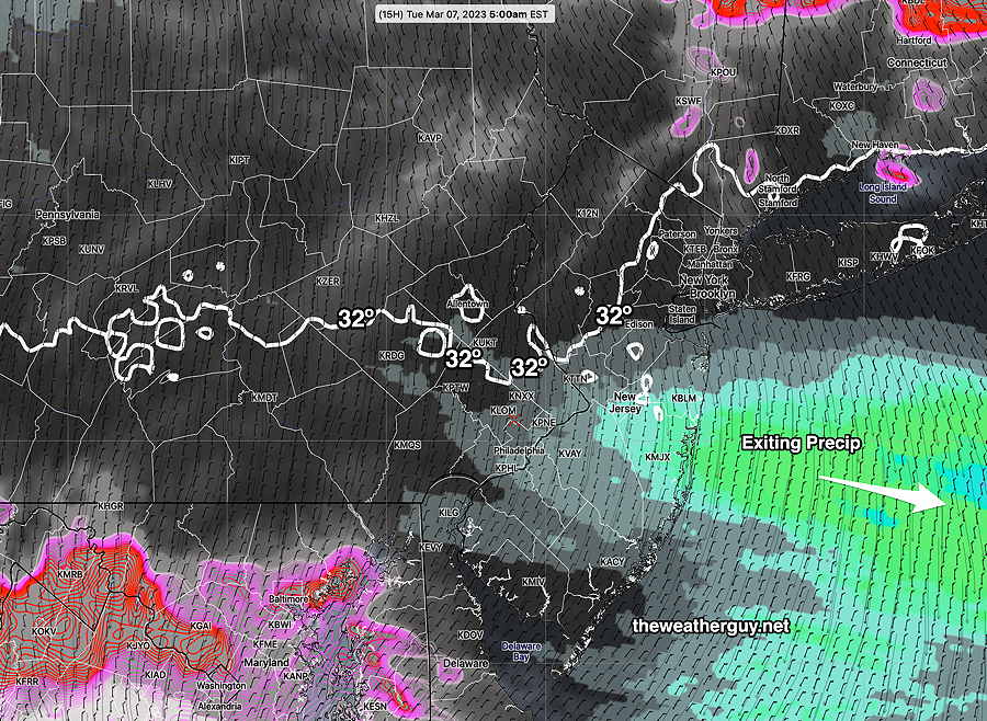
That area is visible on this morning’s hybrid radar—

This morning’s Hybrid Radar with RAP model Omega overlay. Light showers may rotate through about 3 PM (Click on image for a larger view.)


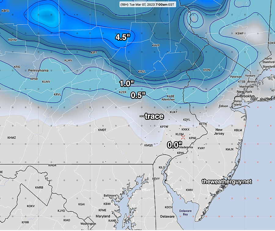
Update Fri 3/10 11:02 PM — Tonight’s models continue to show non-accumulating wet snow showers, from the just outside of the city and north and west, Saturday morning.


Previously Posted Fri 4:51 PM —

This weekend will mark the transition into a different weather pattern than we’ve seen in awhile. Two low pressure systems will move in and develop – one Friday into Saturday and another late Sunday into Monday. These systems will pull cold air down from Canada and the jet stream pattern will become cyclonic and somewhat amplified along the Eastern US.

This translates into below average temperatures, windy and quite unsettled conditions, starting today (Friday) and into much of next week.

Saturday

Low pressure that brought rain Friday night will blossom in the western Atlantic. Upper level low pressure will merge with this storm. Wrap around moisture from this surface low will bring continued cloudy conditions and showers/snow showers on Saturday morning. It will be windy and cold. Some widely scattered showers may linger into the afternoon.

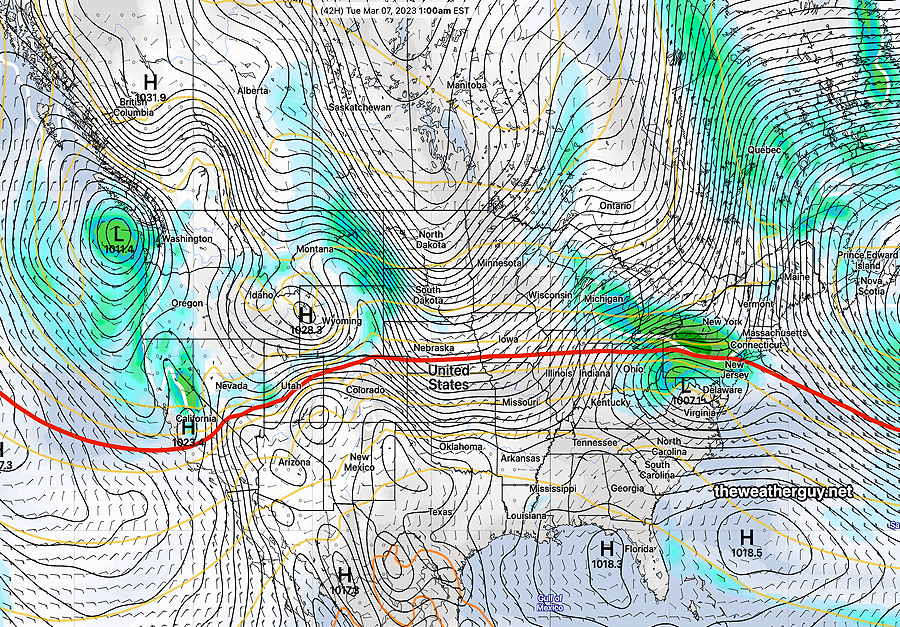
Here’s the GFS for Saturday—

GFS model forecast for Saturday 1 PM. Wrap around moisture from low pressure in the Atlantic will bring rain and snow showers. (Click on image for a larger view.)

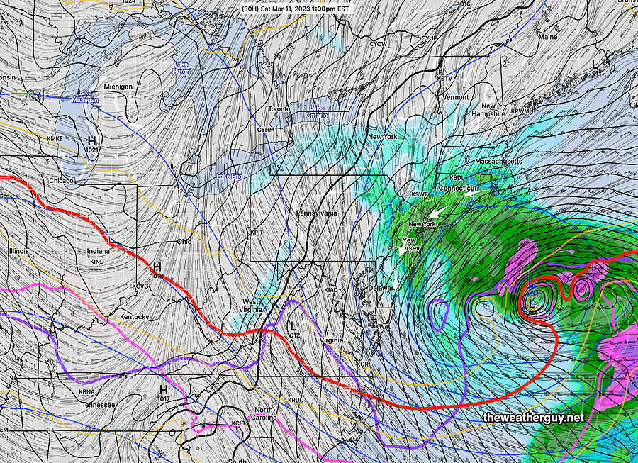
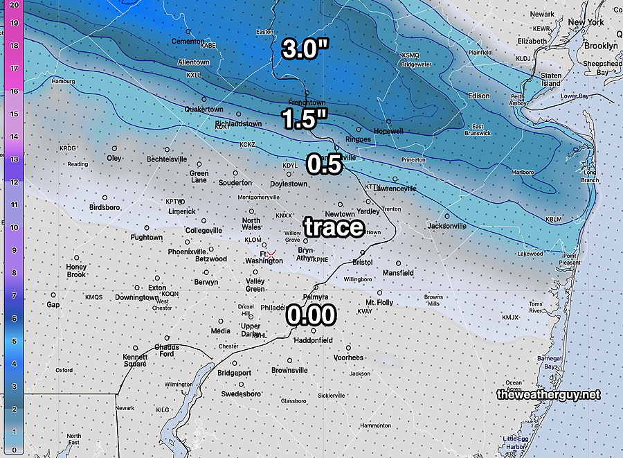
Despite temperatures well above freezing, snow showers are expected to develop in some areas. It would not surprise me if the snow shower coverage is greater than predicted below—

NAM-NEST forecast Precipitation Type for 11AM Saturday. Blue: snow showers (Click on image for a larger view.)

High temperature 45.7º sd 1.5º ( NBM model location Blue Bell, PA)

Sunday

Another low pressure system approaches during the day. Sunday starts sunny through increasing high cloudiness.

Thickening and lowering cloudiness in the afternoon.

Some precip moves in during Sunday evening, which most likely will be rain in most areas.

GFS forecast for Sunday at 7 PM. Low pressure moving in from the west and south. (Click on image for a larger view.)

High temperature 46.9º sd 1.5º ( NBM model location Blue Bell, PA)
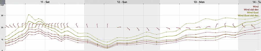
Winds

NBM Wind Meteogram for Blue Bell, PA (Click on image for a larger view.)

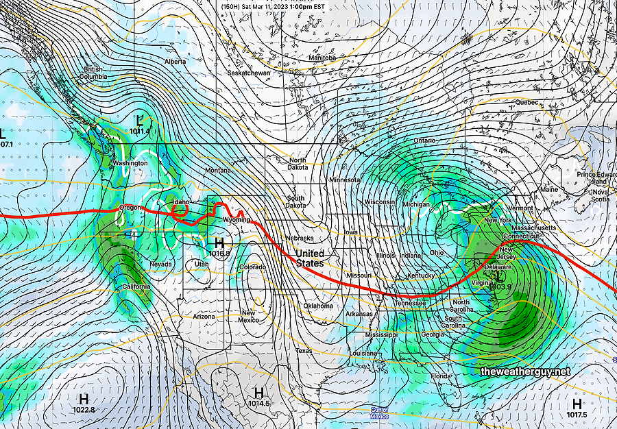
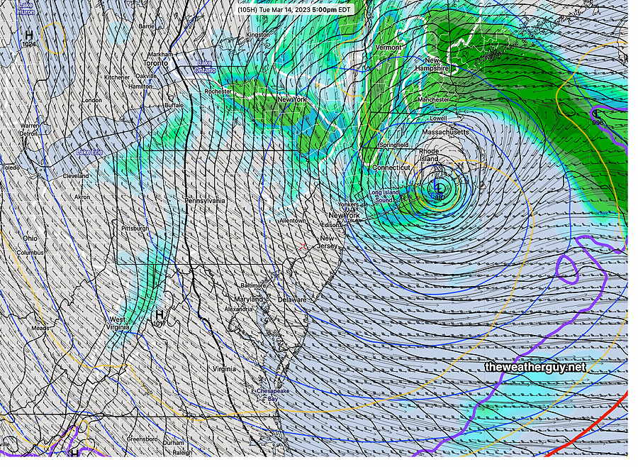
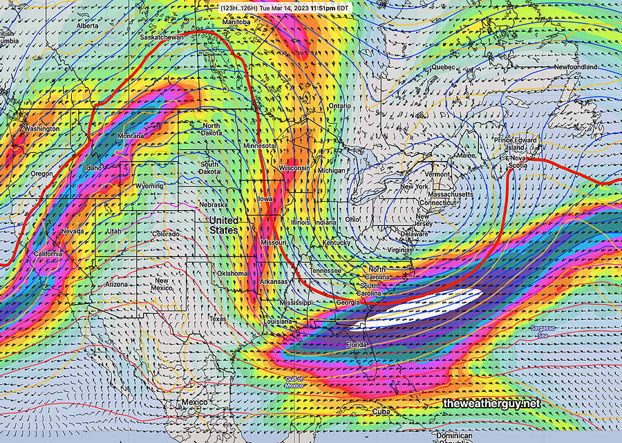
For next week, very deep low pressure develops near Cape Cod. We’ll be affected by windy conditions and cold temperatures.

GFS for Tuesday shows deep upper and surface low pressure systems—

GFS forecast Tuesday. Windy cold and unsettled here. (Click on image for a larger view.)
ECMWF 300 mb wind forecast (with red 500-1000 540 thickness) for Tuesday night shows broad but deep upper air trough in the East with closed low over the Northeast. (Click on image for a larger view.)

Daylight Saving Time and Weather Forecasts

Sunday morning is the beginning of Daylight Saving Time.  I love the extra daylight at the end of the day, but for  “weather nerds”, Daylight Saving Time means the models come out an hour later.  For those of us on Eastern Time, the evening models become available inconveniently late for the next day’s forecasts!

I’ve written extensively about this in past years—

Little Known Facts about Daylight Saving Time and TV Weather Forecasts

Daylight Saving Time and Weather Models

“Check Back at 11” — TV Weather and Daylight Saving Time


THIS WEEK’S WEATHER

#weather #paweather #wx #pawx #philadelphia

Friday Forecast Update & Saturday Outlook—

Update Thu 03/09 @ 5:52 PM — The next weather maker moves in early Friday afternoon. Rain moves in from the west, between 1 and 3 PM Friday. It will become increasingly windy Friday night. About 0.5-0.75″ of rain expected before it ends around daybreak Saturday.

It appears that the primary low will spawn a complex secondary structure early Saturday; low pressure will develop far off the coast to our south and another center near NYC.

The rain and most of the energy will move away on Saturday, but residual moisture Saturday morning will likely result in some snow flurries. Saturday looks to become partly to mostly cloudy in the afternoon with some gradual clearing later in the day.

The system coming in late Sunday is still a rain event for Monday, but may begin as light snow in northern and western suburbs.


Monday’s Storm Trending Warmer

Update Thu 03/09 @ 9:57 AM — Last night’s models have the lower levels of the atmosphere (< 2000 feet) trending warmer, reducing the likelihood of snow, even at the start. What was already a marginal chance for non-accumulating winter precip, at least at the start, has reduced to a very low chance.

This storm is still several days away and additional changes in the forecast are likely to occur.

Nonetheless, we have entered a very active weather pattern with disturbances from the Pacific, affecting California, are rapidly crossing the country and spawning additional low pressure development on this coast. Slight changes in the flow can create big changes in our weather. Stay tuned.


Rain Friday afternoon. Possible Snow-Rain Mix Monday morning

Update Wed 03/08 @ 8:02 PM — Rain is still expected Friday to move in from the west between 1 PM and 3 PM and continue into early Saturday morning. Very slow clearing on Saturday, possibly with lingering sprinkles.

Of interest is a new storm now expected to form Sunday night to our south and intensify as it reaches the coast. The GFS and ECMWF both show a mix of snow and rain possible before daybreak Monday, likely changing to all rain during the day.

Temperatures are expected to be above freezing, so little or no accumulation is currently expected. This is a changing situation.

Here’s the latest ECMWF and GFS for Monday morning—

ECMWF showing 32º surface temperatures north of us. Critical thickness for snow (violet/magenta/red lines) are to our south early, allowing a snow or snow rain mix. (Click on image for a larger view.)

Here’s the GFS—

Latest GFS model is colder than the ECMWF. Has snow falling but not cold enough to accumulate, as 32º (white line) is north of our area. (Click on image for a larger view.)

Something to watch. I’ll keep my eye on any changes.


Previously Posted Tue 5:51 PM —

The weather will continue to be fair and relatively cold through Friday.

An approaching storm on Friday is now being forecast to exit faster than previously predicted.

It appears that rain will begin Friday afternoon with this storm—

Today’s 18z GFS forecast for 3 PM Saturday. Rain starts moving in. (Click on image for a larger view.)

The models have backed away from this being a storm with secondary coastal development. It will not be as deep a storm as previously forecast. The ECMWF model is leading this trend.

Rain likely ends Saturday morning with partial clearing occurring during the day. It will be windy and colder.

Much of next week looks to be colder than average. No snow seen in the forecast.


THIS WEEK’S WEATHER

#weather #paweather #wx #pawx #philadelphia

Snow Accumulation Tonight? Fuhgeddaboudit!

Update Mon 3/06 5:56 PM —This afternoon’s models have taken the trace snowfall predicted by last night’s models and have moved accumulations even closer to zero. The trend today has been for accumulating snowfall to be even further northward.

Here’s the very latest GFS snowfall accumulation for tonight—

Today’s 18z GFS shows accumulating snow from Allentown northward. The blue contours are every 0.5″ snow increments. (Click on image for a larger view.)

While some snow is expected to fall in our area, minimal accumulating snow expected due to temperatures being above freezing and “surface skin” temperatures also above freezing during the time of the precipitation.

While temperatures may fall close to 32º just outside the city by 7AM, it will occur after the precipitation has exited the area.

NBM showing exiting precip as 32º line drops south at 5AM Tuesday—

NBM foreast clouds (black) 32º line (white) precip (shades of green/blue) (Click on image for a larger view.)

Monday Forecast Update

Update Mon 3/06 9:05 AM —It appears that the fast moving weak storm for tonight will bring down enough cold air to allow the precipitation to fall as snow. The timing of the storm, occurring at night, helps with this colder thermal profile.

While the light precipitation in the immediate PHL area will fall as snow, surface temperatures will be above freezing in areas south of Doylestown. No accumulation on roadways and little accumulation on grassy surfaces expected in these areas.

Snow starts 11PM to midnight and ends before daybreak Tuesday.

North of Doylestown, accumulating snow is forecast by the models. There’s quite a range of accumulations forecast—

NBM:

NBM Snow accumulation forecast (Click on image for a larger view.)

NAM-NEST:

NAM-NEST snow accumulation (Click on image for a larger view.)

Previously Posted Sun 5:55 PM —

I don’t see much significant weather this coming week until next weekend, although a pattern change to colder weather is hinted at for us for the following week, according to the GEFS.

With the exception of a warmer Monday (53-54º), for the rest of the week, highs will be in the upper 40’s (Blue Bell), close to the seasonal average high of 49º (Blue Bell) and 50º (Philadelphia).

This Week’s Weather Highlights

Monday night—

A weak storm moves through Monday night with some rain. It continues to be windy, especially Tuesday through Wednesday. (Well, it IS early March).

GEFS forecast for Tuesday at 1 AM. Weak low pressure moves just to our south with rain. Clearing later Tuesday morning.

Friday Night into the Weekend

Another storm approaches for next Saturday and a strong secondary low, a coastal storm, develops.

GEFS forecast for Saturday at 1 PM. Rain and wind due to a secondary low. (Click on image for a larger view.)