Update Sat @ 9:50 PM — Sunday’s forecast is unchanged. Some “interesting weather” appears to be developing for the late Monday through Tuesday time frame. A deep upper low will spawn a deep coastal secondary low Monday night through Tuesday. Stay tuned.
Update Sat @ 9:31 AM — The uncertainty in the cloud cover remains for Saturday. The short range, higher resolution models are more optimistic about brightening skies and some sunshine during the mid-day hours. But the 2AM runs of the the GFS and ICON have the clouds hanging in. I’m now leaning towards less sunshine, but with low confidence.
All models now show showers moving in from the west, starting as early as 2-6 PM. The model blend (NBM) which is supposed to reconcile these forecast differences has showers moving in about 4 PM.
Update Fri 10:43 PM— Tonight’s models just becoming available, continue with a huge range in cloud cover for Saturday. I’m staying with the forecast below. Showers as starting as early as 3-4 PM, lasting into the evening, appear to be more likely.
The general forecast for this weekend is easy if you’re not into the details. Basically it will be partly cloudy/partly sunny with a chance of light scattered sprinkles late Saturday afternoon.
The detailed specifics of the weekend forecast are much lower confidence than usual.
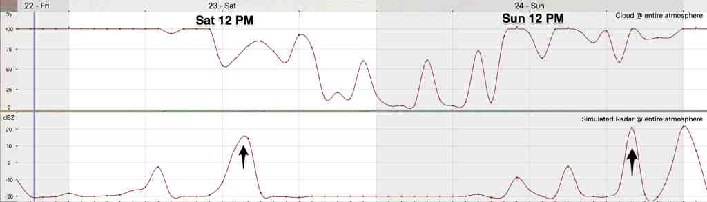
Much of the forecast is driven by upper air disturbances (described on Tuesday) which are difficult to pin down. There’s a wide range in the forecast levels of cloudiness, especially on Saturday. Additionally, over the past few days, the timing of the showers/sprinkles (if any) from an upper air disturbance has moved from the morning to the mid to late afternoon.
Saturday
Going with a blend of the NBM, HRRR, GFS and ICON models, it looks like Saturday morning will be cloudy. Clouds break for a mix of clouds and sunshine sometime between 11 AM and 2 PM. There’s a slight chance of widely scattered light sprinkles after 4 PM.
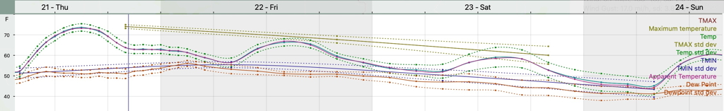
High Temp 61.8º sd 3.3º (NBM forecast, Blue Bell). The high sd (standard deviation) reflects the high uncertainty in the amount of cloud cover. (Average seasonal high is ~62°.)
Mostly sunny in the morning with a period of increasing cloudiness in the early afternoon, possibly breaking for some sunshine late afternoon.
High Temp 61.4º sd 2.1º (NBM forecast, Blue Bell).
Looking ahead
After months of heavy rainstorms, recent weeks have been very dry. Our next rainfall of any significance is not on the horizon. Monday was supposed to be somewhat rainy, but much of that rain will move to our north.
It’s interesting that the publicized NWS Climate Center long range winter forecast released yesterday had the above-average precipitation area just north of our area, with our area having equal chances of above or below average precipitation.
Some rain Monday night into Tuesday may provide some relief in the dryness. A deep upper low will spawn a coastal low Monday night through Tuesday. High winds and heavy rain are possible