Following a cold front passage on Monday, temperatures will get colder than average for our area for most of the week and coming weekend.
A highly amplified jet flow will result from cold air dropping south from Canada and warm air pushing up the central US. We’ll be on the cold side of this seesaw at least through Friday.
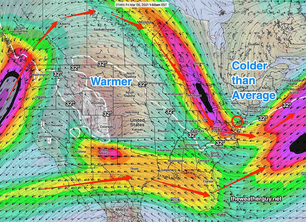
The statistical/ensemble version of the GFS, the GEFS (Global Ensemble Forecast System) shows the configuration of the northern jet flow as well as the configuration of the southern stream for Friday at 1AM —
GEFS jet wind flow at 300 mb 1 AM Friday Notice that any phasing between the two jet flow as well as any storm development occurs well east of the US, in the Atlantic. (Click on image for a larger view.)
Things will be cold for our area, but quiet storm-wise.
As a character on a popular TV comedy series might have put it “NO STORM FOR YOU.”
Things look even quieter next week.
Then again, the current predictions of the jet configuration is a major change in the model forecasts from just a day ago. Things could always change.
Forecast Updated Sat 5:29 PM — There had been uncertainty with the high temperatures today (NBM standard deviation was very large at 4.4º) and we ended up far below the 57º predicted last night, although the timing of the clearing and sunshine were on target.
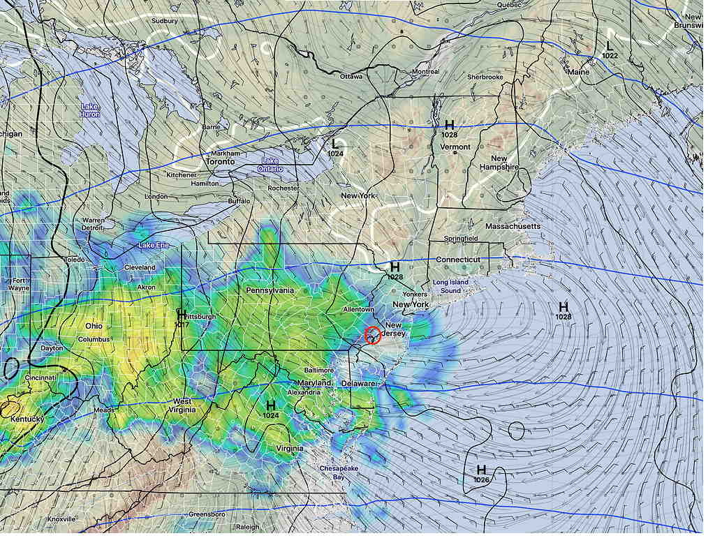
For Sunday, the models continue to forecast cloudy skies with rain, beginning about 9 AM.
GFS simulated radar 9AM forecast (Click on image for a larger view.)
It will become windy on Sunday afternoon and will be chillier with a high temp of 46º ± 3.0º
Rain will taper off a bit early Sunday evening before another round of rain moves through later Sunday night ahead of a cold front passage Monday.
from Friday evening…
A warm front will move through Friday night and will bring rain to our area, although several models have the rain starting as snow around 1AM tonight in northern Montgomery and Bucks counties. It all changes to rain before daybreak.
The rain tapers off during the morning on Saturday. Models earlier this week had the rain ending early, but right now, it looks like the rain ends about 10-11 AM Saturday.
Additionally there should be gradual clearing during the afternoon with some sun by 2- 4PM.
Temperatures following the warm front will be mild Saturday. There is a bit of uncertainty with the timing of the clearing and cloud cover; as a result, the high temperature of 57º (Blue Bell, NBM-adjusted) may turn out to be lower if clouds linger.
It will be breezy on Saturday with occasional gusts mid afternoon.
For Sunday, the warm front is expected to be followed by a weak cold front Saturday night. The cold front will stall just to our south as a wave of low pressure moves up along the front for Sunday.
One of these waves of low pressure will bring rain for us on Sunday.
Sunday will becloudy with rain, starting early morning and lasting through the day. It will be cooler with high temperature 49º (Blue Bell, NBM-adjusted).
The National Weather Service/NOAA creates a weather prediction model that is a statistical composite of many different models— it’s called the “NBM” or “National Blend of Models”. The NBM is created and updated hourly by NOAA and is the product of about 8-9 years of development. It’s current version, 4.0, became operational this past December 2020.
The NBM is a sophisticated and advanced attempt to combine the best forecasts of numerous weather models including multiple U.S. short/long range/ensemble models, several Canadian models/ensemble models and the European model/ensemble models. It also combines various “model output statistics” (“MOS”) and hourly “LAMP” forecasts.
It attempts to achieve its aim by re-examining the forecasts of the models hourly and comparing those forecasts to actual measurements adjusted to actual measured conditions six hours earlier. From the comparisons to actual conditions, it statistically weights the forecast going forward to the best performing model(s) six hours earlier.
The NBM ingests different model runs and forecast statistics at scheduled times during the day and creates a variety of forecast products, including maximum/minimum forecast temperatures and precipitation forecasts.
The NBM is the model I’ve been using for my high temperature forecasts.
I’ve noticed something for awhile, recently confirmed today by an official notice. The NBM high temperature forecasts (“TMAX”) are too low, and the error is higher with higher expected TMAX temperatures.
(I’ve been including the “sd”(standard deviation) in my forecasts for months. I’ve noticed that the actual TMAX is often a degree or so higher than the NBM predicted value PLUS its standard deviation.)
Today, the NBM predicted TMAX for Blue Bell was 49º with an sd of 4.4º The actual TMAX was 53º.
So the actual TMAX was = TMAX + sd!
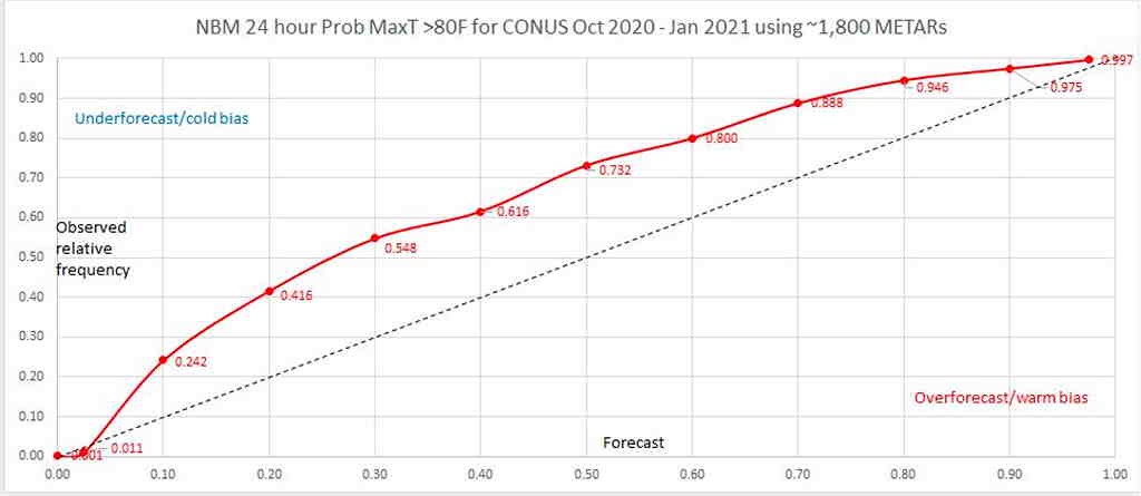
The NOAA statistical modeling group today released a report today. This graphic captures the problem of the cold bias in the NBM max temp forecasts.
NBM TMAX Bias (Click on image for a larger view.)
With this disclosure, I’ll be getting rid of my inclusion of the standard deviation in my forecasts (as had been my practice these past six months) and instead will simply be adding the sd to the forecast high temp going forward…and hoping for the best.
With the recent disclosure that the precipitation statistics are also biased too low, we can hope for an early release of NBM version 4.1 or NBM v.5. (Actually, the precipitation problem is being addressed with an update in March.)