[su_note note_color=”#ffffff”]Updated Wed 10:30 PM —Tonight’s models have reduced Thursday’s late afternoon showers to light and widely scattered. [/su_note]
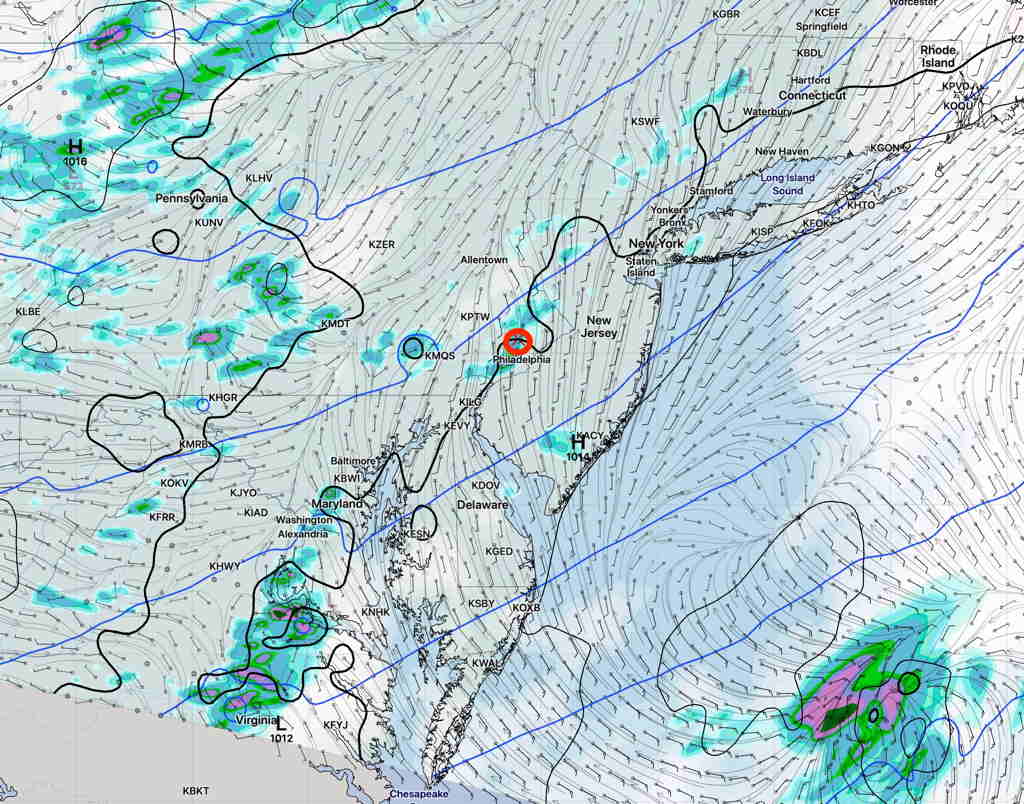
[su_note note_color=”#ffffff”]Updated Wed 07:54 PM — Thursday may see some scattered showers and thunderstorms in the Philadelphia area, especially late afternoon, as an upper air disturbance rolls through. But large scale rain is going to pass us by.
NAM NEST forecast for 6 PM Thursday (Click on image for a larger view.)
[/su_note]
You may have noticed that our area has been missing most of the organized rain and thunderstorms lately. Yes, we’re getting some scattered showers and thunderstorms occasionally, but an organized large scale rainstorm or rain with a frontal passage hasn’t materialized in the Philadelphia area and eastward into NJ for awhile. Most organized activity hasn’t been making it past central Pennsylvania.
Last night’s frontal passage dynamics sheared off to our northwest.
We are in a somewhat persistent pattern with an upper air trough bringing little moisture from the northwest. It’s a significant change in pattern from what had brought recurrent heavy rains over past previous months.
GEFS forecast for Sunday 3 PM
I don’t see any change on the horizon. Expect mostly dry conditions to continue.
[su_note note_color=”#ffffff”]Updated Sun 12:15 PM — This morning’s models still maintain the possibility of afternoon scattered showers and thundershowers, mostly north and west of the city. [/su_note]
[su_note note_color=”#ffffff”]Updated Sat 10:50 PM — Little change In the Sunday forecast shown below. Fog and clouds break between 9:30 AM and 11AM. High Temp 84.2° sd 1.2° Afternoon showers much less likely except in northern suburbs. [/su_note]
[su_note note_color=”#ffffff”]Updated Sat 08:29 AM — Most of last night’s models onboard for showers and thunderstorms between 12 PM and 5 PM. Two probability maxima- about 1-2 PM and about 4-5 PM. Some cloudiness moves in about noon. These storm’s main threat will be mostly moderate to heavy rain where they occur. [/su_note]
The upper air cyclonic flow will continue to cause instability as warm, increasingly humid air moves in from the south. Both Saturday and to some extent Sunday will be similar to Friday, weather-wise, with scattered showers and thunderstorms.
Tonight’s HIRESW just available shows showers and thunderstorms developing as early as 12 PM.
Saturday —
Sunny in the morning, considerable cloudiness after noon time..
Scattered showers and thunderstorms develop 12-5 PM.