WINTER WEATHER UPDATE -MON 6 PM

[su_box title=”Winter Weather Update: Monday Evening ” box_color=”#defcdc” title_color=”#000000″]Tonight’s NAM has become available. The NAM has snow starting about 9-10 AM Wednesday and continues as snow until 4-6 pm, when it starts mixing and changing to all sleet by 7pm. Temperatures remain at or below freezing until early evening.

Based on QPF, 4-6 inches of snow may accumulate before the changeover. A further changeover to rain will occur later in the evening. Heavier rain about midnight.

This is a preliminary forecast. Expect changes with future model runs.  [/su_box]

From earlier..

Here’s the latest on the snow that’s expected for Wednesday.  As usual, there’s a fair amount of model disagreement.

This morning’s GFS had the snow starting as late as noon, however this morning’s run of the new FV3-GFS had the snow starting about 8 AM.   This afternoon’s high resolution NAM NEST has the snow starting about 10 AM.

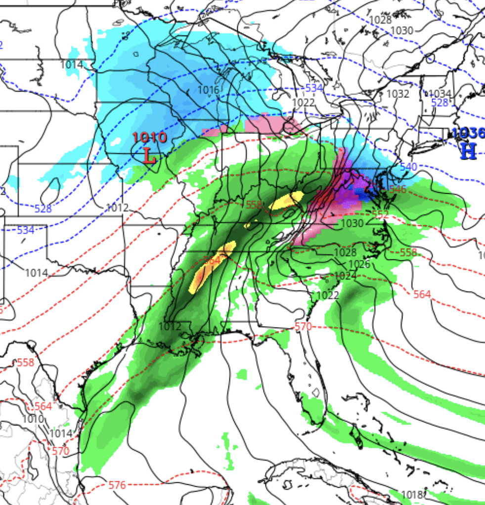
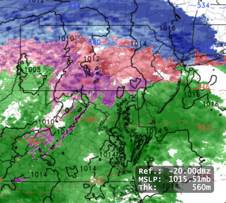
This will be a storm where the total QPF will be divided into snow, sleet and rain components.  Most of the models are in general agreement that there will be about 3-6 inches of snow, with a lean towards the lower end, before a changeover to sleet and then eventually to rain.  BTW, the European (ECMWF) has 4-6 inches for our area.

Models have the changeover from snow to sleet anytime from 3PM to 7 PM.   Sleet will likely fall for several hours as it mixes with rain. The heaviest precip will occur as rain towards midnight and after.

As discussed earlier, this will be another “warm air aloft over-runnng cold air at the surface” type system, actually a warm frontal-type system.

The forecast accuracy for this type of system has little to do with the “track of the storm” as they say on TV, but rather with the three dimensional thermal profile of the atmosphere and the eventual placement of the moisture plumes and dynamics.   There’s no storm center “to track” here; it’s more subtle than that.

Getting the forecast even close to correct probably won’t be possible until Tuesday night’s model runs.

WINTER WEATHER OUTLOOK

[su_box title=”Winter Weather Update: Monday 12 Noon” box_color=”#defcdc” title_color=”#000000″]Based on this morning’s models, the snow will start later in the morning in Philadelphia. The NAM has it starting about 10 AM Wednesday, while the GFS about noon in Philadelphia. Earlier starts southwest of the city, later northeast of PHL.[/su_box]

Details from earlier…

About last night… pockets of sleet developed about 11 PM around Philadelphia and areas to the west north and west.  The colder thermal profiles of the NAM did better than the warmer GFS.

So what about this storm on Wednesday? Wednesday features a similar set up as the several past snow—> sleet—> rain scenarios we’ve had this  winter. Low pressure will be to our west and blocking cold high pressure will be to northeast –

GFS forecast
GFS Forecast for 1 PM Wednesday

An ample flow from the same jet flow discussed last week will bring the moisture.

Unlike many snow ‘storms’  we get with deep low pressure developing along the coast in most winters, this will be another “warm air aloft over-runnng cold air at the surface” type system, actually a warm frontal type system.  The actual low pressure system is weak and unimpressive.  (There is some suggestion that low pressure may develop off the coast, but that is just one of many uncertainties now.)

This time, we are expected to have a somewhat deeper cold air at the surface, allowing for lingering snow and sleet before the changeover to rain.

With thermal profiles aloft playing such a huge role, we won’t have a firm handle on things until sometime Tuesday evening.

[su_note note_color=”#d9f2da”]Currently there is a range of snow totals.  Precip starts early morning 7-10AM from southwest to northeast…Current estimates are in the 3-6 inch range for Philadelphia, then prolonged sleet, changing to rain in the evening.  [/su_note] Stay tuned.

WINTER WEATHER UPDATE- SUNDAY

[su_box title=”Sunday Weather Update  4:45 PM” box_color=”#defcdc” title_color=”#000000″]Based on this afternoon’s model runs, (yes, the “off-hour” runs that tend to be a bit off), a mix of precip should start between 6 and 8 PM.

The NAM graphic below still is reasonably close to where rain vs a rain-sleet mix will fall, just north and west of the city.

Most models have the changeover to all rain in the immediate area by about 9 PM. I’m interested to see if that occurs, because there’s a layer of cold air at 3000-4000 feet that is predicted to remain below freezing until midnight.  Anyhow, it will change to all rain eventually. Latest QPF is back to over 0.40 inches water. [/su_box]

from earlier today…

The latest NAM and GFS model data has become available.   QPF values have reduced on the NAM to about 0.36 inches water and 0.43 inches water on the GFS for gridpoint Philadelphia.

NAM thermal profiles (which I prefer) are borderline cold for sleet or a mix of sleet and rain when the precipitation starts.   It then changes to all rain by midnight.  No accumulation expected in or around Philadelphia.

NAM Nest graphic
Hi Resolution NAM NEST for 10 PM Sunday night showing sleet

The GFS is warmer and somewhat wetter.  The GFS has no sleet for our area.

So this is a lower confidence forecast for sleet.

As for the start time, here is a NAM-NEST graphic for precipitation moving in from the west about 8:30 PM.  Notice that the precip may start far north and far south of Philadelphia, before it fills in near Philadelphia.

NAM Nest  precipitation graphic for 8:30 PM tonight.  Dark grey is rain/sleet

(Sometimes these ‘holes’ in the precipitation field are artifacts, but several model runs have showed this.)  I guess we’ll see what happens.

With no accumulation expected,  this is really a non-event from a winter weather perspective

[su_note note_color=”#d9f2da”]I’ll soon be turning my attention to the well-advertised storm expected for Wednesday.

As we can see, even with tonight’s rain storm, predicted QPF values can change over 12 hours, as can thermal profiles, especially with these transitional storms. So it’s really just speculation regarding the specifics until we’re in the 24 hour time frame. [/su_note]