WINTER STORM OUTLOOK

[su_box title=”Winter Storm Outlook Update Tues 9 PM” box_color=”#defcdc” title_color=”#000000″]Reviewing today’s models, there isn’t much change from this morning’s update. The small disturbance that will accompany a warm front will bring some light snow Thursday night. Current QPF is 0.12 inches water, or 1-2 inches from midnight Thursday to daybreak Friday.

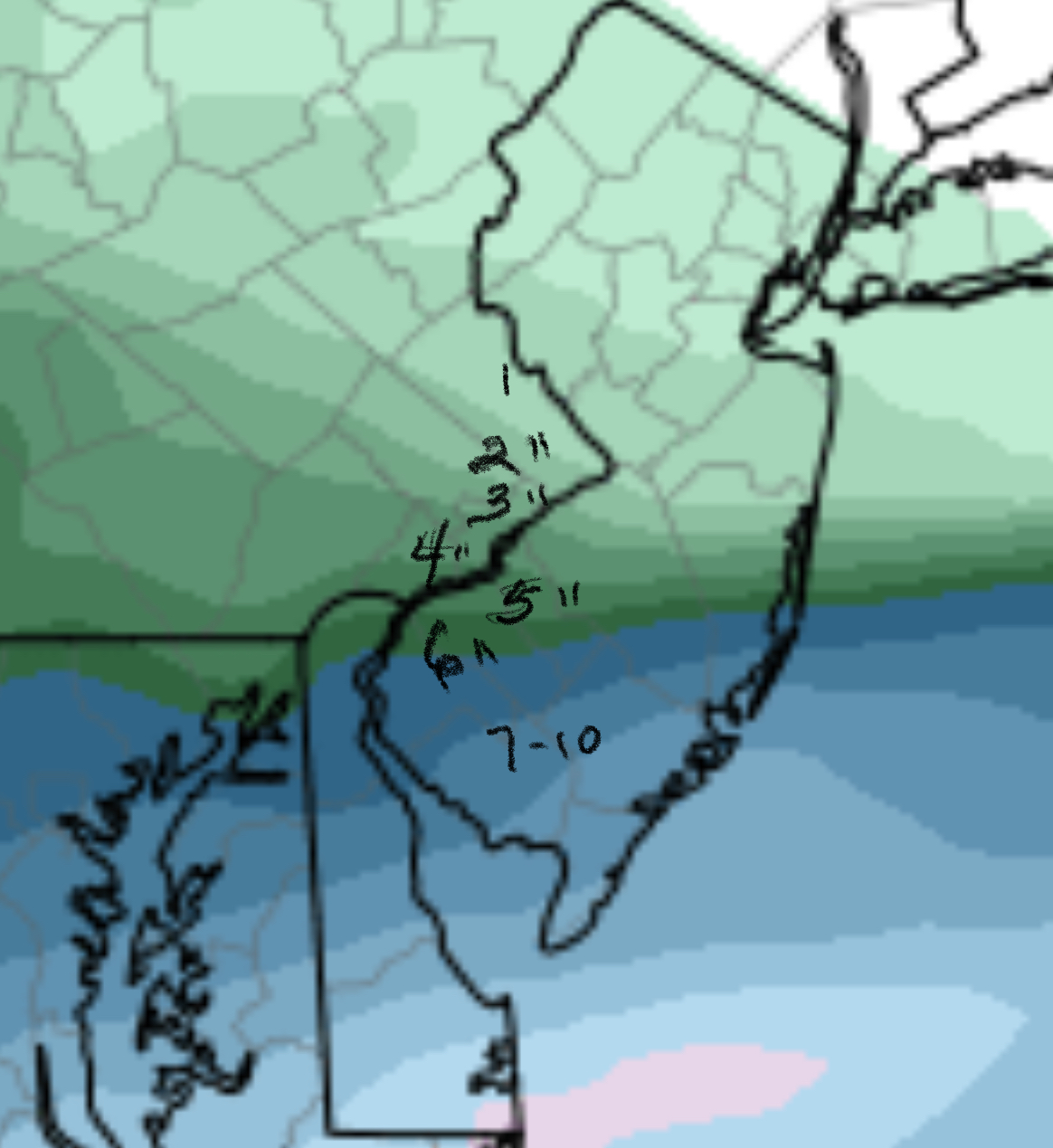
Most models have the large storm for late Saturday into Sunday tracking far enough inland that the precipitation will be mostly rain for PHL and immediate suburbs; the changeover to snow looks to be late enough to limit snow accumulations significantly. Stay tuned. [/su_box]

[su_box title=”Winter Storm Outlook Update Tues 8 AM” box_color=”#defcdc” title_color=”#000000″]The small disturbance that will accompany a warm front will bring some light snow Thursday night.

The large storm for late Saturday into Sunday is now forecast to track far enough inland that the precipitation will be mostly rain for PHL and immediate suburbs; the changeover to snow on Sunday may be late enough to limit snow accumulations significantly. This scenario has been one that has alternated with a more coastal track.

Stay tuned. [/su_box]

[su_box title=”One more thing… ” box_color=”#defcdc” title_color=”#000000″]While focusing on the weekend, I neglected to mention a warm front type snow that is forecast to occur this Thursday night into early Friday morning. There’s some question whether it will be snow or a mix, but tonight’s NAM has it as snow. An active week coming up. Stay tuned. [/su_box]

Previous post —

The first truly impressive storm of this winter season is forecast to affect our area in the late Saturday through Sunday timeframe.

This storm has been predicted by the long range models for well over two weeks. All models are currently on-board for some sort of winter precipitation, very windy conditions, followed by deep cold.

As always, there are differences among the models regarding the speed of the initial impulse, degree of intensification and the precipitation type. The GFS, the FV3-GFS and the ECMWF (European) are the most impressive.

GFS-FV3 forecast
GFS-FV3 forecast for Sunday at 1 PM

As of today, it appears that precipitation will start as rain Saturday night, then change to a mix of sleet and rain and then a final changeover to all snow from west to east during the day Sunday.

As we know, the models didn’t accurately depict the the past weekend precipitation, so it’s a shot in the dark to predict snow totals 6 days in advance.

That said, a 6-10 inch snowfall (based on the latest ECMWF) with high winds is looking possible at this time, north and west of Philadelphia. Philadelphia may stay a mix for a longer period. This storm looks to be impressive, with high winds. Stay tuned.

SNOW UPDATE

The 1 AM run of the NAM reduced the QPF considerably and we are back to the original forecast from Friday of 1-2 inches with sharp cut off north of Philadelphia.

Light snow ends shortly after noon today for Philadelphia but continues in southern Delaware and Chester counties and southern NJ.

[su_note note_color=”#d9f2da”]So… this was a boundary condition forecast which was poorly handled by the NAM model. The NAM has done well in these situations in the past, and it was prudent to report its forecast as a high probability.

The NAM forecast was predicated on a secondary low intensification at the coastline that will take place, but slightly further south.

Looking back, the GFS did better with the timing (starting earlier Saturday evening) and with the lower QPF.  I can think of many past storms where the NAM did better than the GFS.

The NBM did well with the QPF, but poorly with the onset of the snow. It had the snow starting 10-midnight which is what I used.   It also had forecast the secondary low intensification for Sunday night, which appears to be the same error made by the NAM.  [/su_note]

WINTER WEATHER UPDATE

[su_box title=”Forecast Update Sat 10 PM” box_color=”#defcdc” title_color=”#000000″]Tonight’s NAM has moved down the QPF to 0.37 inches water for Philadelphia. The graphic with the tight gradient below is still a realistic forecast for snowfall — areas in far Northeast Philadelphia will have less snow than areas near the airport. Areas central to Philadelphia can expect 3-4 inches.

The accumulation will be extremely location dependent, south to north.

Here are some changes— light snow continues into Sunday evening in areas south. Far South Jersey May have over 1 foot of snow. [/su_box]

An unusual forecast is unfolding, with a tight gradient of precipitation and larger possible snow totals. With these tight gradients, I usually go with the NAM model.

This morning’s NAM had a QPF of 0.92 inches water at the airport, rapidly diminishing to very low amounts at Trenton.  This seemed like an error.  This afternoon’s NAM run is still running much higher than other models, with a QPF of 0.42 inches water at the airport and a tight gradient of decline.  I don’t usually use graphics for snow totals but the sharp gradient in amounts can only be depicted graphically:

NAM Forecast
NAM Forecast QPF through Sunday afternoon

This morning’s models also depicted the sharp gradient, but the QPF values were about half of the NAM prediction.

Based on the NAM, 2-5 inches will fall, depending on location north to south.

Snow will start between 10 and midnight tonight and will continue to about 1 PM on Sunday.  It’s possible that tonight’s model runs will back off on the high QPF values, but you’re reading this blog to find out what the possibilities are.