WINTER WEATHER UPDATE – FRIDAY

[su_box title=”Winter Weather Update Fri 5 PM” box_color=”#defcdc” title_color=”#000000″]Another quick update. This afternoon’s NAM and GFS show a faster storm onset. Precipitation starts about between 3-5pm Saturday afternoon. It’s likely to start as snow, with 1, possibly 3 inches before a rapid changeover to sleet and then rain.

Heavy rain by early evening Saturday. (Freezing rain likely far northwest in Allentown up until midnight.) Rain tapers in the morning Sunday as temperatures plummet and winds pick up. Minimal accumulation expected in the immediate PHL area when all is said and done.

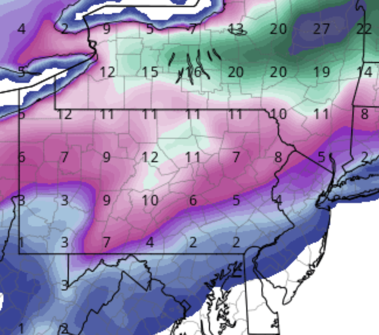
Temperatures are forecast to drop from 49 (GFS) or 42 (NAM NBM) to 30 by 1 PM, then falling further during the afternoon to 20 by 7 PM and single digits at night. Windy conditions may dry some open roadways, reducing icing, but standing areas of water or draining areas from the side of roadways will freeze.

The next model runs come out between 9 PM (NAM) and 10:45 (GFS). I’ll update before 11 PM. [/su_box]

[su_box title=”Winter Weather Update Fri 10 AM” box_color=”#defcdc” title_color=”#000000″]A quick update. This morning’s NAM shows a faster storm onset. Precipitation starts about 4pm Saturday. A very fast changeover to sleet and then rain. Freezing rain possible far northwest. Heavy rain by early evening Saturday. Rain tapers in the morning Sunday as temperatures plummet and winds pick up. Minimal accumulation expected in the immediate PHL area when all is said and done.

NAM accumulations
NAM forecast total accumulations by Sunday noon.

[/su_box]

Last night’s models did very well with the light snow that should be ending within the next hour.

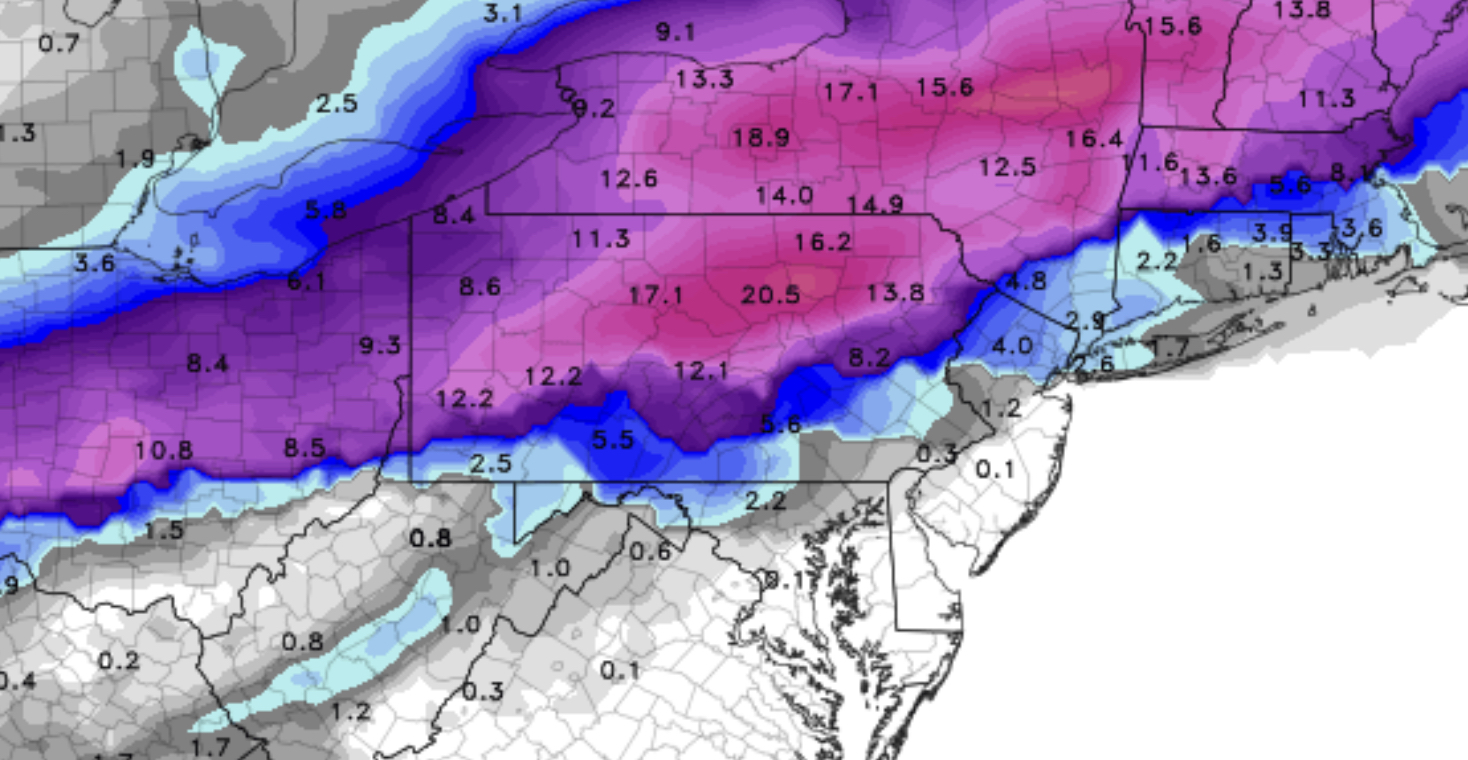
Here’s the latest on the Saturday to Sunday storm. For Philadelphia and its immediate suburbs, a total storm QPF is about 1.95 inches water. Most of this precipitation will be rain, but the beginning and end of the storm will have snow or mixed precipitation.

Based on the latest 06Z run of the NAM and GFS models (1AM last night), the NAM is holding off much of the precipitation until temperatures rise enough when the precipitation begins towards evening. Temperatures in all levels of the atmosphere will minimally support snow, so between 5 and 7 PM Saturday, expect some light snow rapidly mixing with sleet and rain and then all rain by 9 PM. In the far northwestern suburbs, an extended period of sleet and freezing rain may be occur and areas near Allentown may remain a frozen mix until midnight.

The GFS also has the atmosphere warming, but it has more precipitation starting somewhat earlier in the late afternoon, with greater mixed precipitation accumulating before the changeover to rain about 9 PM.

The Arctic front moves through about daybreak Sunday. Temperatures plummet from about 40 at 7 AM to 28 at 1 PM and 17 by 7 PM. Little moisture is left with this drop in temperatures. A change back to snow is expected Sunday morning, but accumulations in the immediate PHL area and surround suburbs will be minimal Sunday, according to latest models.

Stay tuned for more updates. We’ll be in better range for specifics tonight and tomorrow morning.

WINTER STORM OUTLOOK

[su_box title=”Winter Weather Update Thurs 11 PM” box_color=”#defcdc” title_color=”#000000″]For tonight’s light snow, the latest NAM QPF is 0.15 inches water, the GFS 0.10 and NBM 0.07. This translates into 1, possibly 2 inches of snow ending about 7 AM Friday.

Tonight’s NAM and GFS have light snow starting late afternoon Saturday, quickly mixing with sleet and some freezing rain, then all rain during the early evening hours. There may be an inch or so of accumulation before the changeover, with higher amounts far northwest.

Rain continues heavy through the night. Temperatures are now forecast to only reach the 40s overnight.

With daybreak Sunday, rain changes back to mix of rain, sleet and snow as temperatures plummet to 30 by noon. Temperatures drop further as the day progresses. Precipitation also ends by noon. Accumulations as shown in the NAM graphic below still hold. Will have a better handle on specifics tomorrow. [/su_box]

[su_note note_color=”#d9f2da”]I did want to mention that many of the NWS research websites and experimental models are unavailable due to the government shutdown. [/su_note]

[su_box title=”Winter Weather Update Thurs 1 PM” box_color=”#defcdc” title_color=”#000000″]For tonight’s light snow, this morning’s NAM is clocking in with a QPF of 0.15 inches water. The GFS 0.13 inches water. 1-2 inches of snow starting 10-midnight and ending about 7 AM Friday.

For the weekend storm, IGNORE the graphic from the ECMWF I posted earlier. As I said, I think it’s overestimating the snow forecast big time.

This morning’s NAM and GFS have light snow starting late afternoon Saturday, quickly mixing with sleet and some freezing rain, then all rain during the early evening hours. Rain continues heavy through the night.

With daybreak Sunday, rain changes back to mix of rain sleet and snow. Minimal accumulations expected, even north and west of the city.  

Here’s the likely snow totals by the end of the storm:

NAM snow accumulations
NAM Forecast total snow totals by end of storm Sunday.

[/su_box]

[su_box title=”Winter Weather Update Thurs 8 AM” box_color=”#defcdc” title_color=”#000000″]For tonight’s light snow, the NAM is still clocking in with a QPF of 0.17 inches water. 1-2 inches starting 9-11 PM and ending about 7 AM Friday.

The models are all on board for an earlier and faster storm Saturday into Sunday. (Previous model runs had the changeover back to snow about noon, Sunday. Now the changeover is predicted during the morning Sunday and precipitation ends early afternoon.)

There are considerable differences in the predicted thermal structure during the changeover. The latest European (ECMWF) has significant snow for Philadelphia. (See map below). I don’t currently think this is correct.

ECMWF
ECMWF Snow accumulations by noon Sunday.

Based on the average NAM/GFS models, 2-4 in Philadelphia by Sunday noon.  I think this may be too high as well.  Stay tuned.

[/su_box]

[su_box title=”Winter Forecast Update Wed 11:00 PM” box_color=”#defcdc” title_color=”#000000″]Tonight’s NAM has the snow starting about 9pm Thursday night. QPF values 0.16 inches water. 1-2 inches of snow. Ending about 7 am Friday morning.

Additionally, the Saturday night storm is depicted by the NAM to be even faster, exiting our area early morning Sunday, almost 8 hours faster than previously predicted by the GFS. (The NAM forecast range has just come into Sunday morning.)  That would mean even less snow on Sunday morning. The uncertainty with this weekend storm seems less about track and more about phasing and speed. The trend is less phasing and more speed, faster exit.. [/su_box]

Previous post-
Things continue to evolve with the storm for Sunday. But first, let me talk about the light snow for late Thursday night into Friday morning.

A warm front type system will bring light snow, starting around midnight Thursday and ending about 7 AM Friday morning. QPF values range from 0.16 NAM to 0.14 GFS to 0.07 NBM. Most likely accumulation is 1-2 inches.

Now for the storm on Saturday night into Sunday.  Here are the current trends –

The latest GFS and FV3-GFS have the storm moving faster. Light snow starts about 4-5 PM Saturday afternoon, but quickly mixes with and changes to rain.

Later model runs will allow a better guess of how much snow will accumulate before the changeover to rain.

Heavy rain Saturday night into Sunday morning. The rain will be accompanied by increasingly high winds. Late Sunday morning, a strong cold front will pass through; the rain will change to snow as temperatures drop from the 50s to the 30s by mid afternoon and into the 20s by 7 PM.

While the total QPF is about 2.00 inches water, it now appears the the changeover to snow on Sunday will be brief and only about an inch or two of snow will accumulate in and around PHL as temperatures drop. It appears that the influx of cold air will cut off much of the moisture, reducing snow totals.

Much of the precipitation will become spotty by late afternoon and should be over early evening. The big impact will be winds and rapidly sinking temperatures. Unclear how much icing will be a problem, but it’s likely since wet areas will freeze over.

This storm forecast is still in flux.  Stay tuned.