Update Mon @ 8:05 AM — I spoke too soon. I think I see some flakes out there! Faith in the models restored!
Update Mon @ 7:47 AM — It reached 50º in Philadelphia and 47º in Blue Bell last night between 2-3 AM.
The models show the current showers we’re getting as snow showers, but it’s too warm in the lowest 2000 feet of the atmosphere and it looks like rain to me.
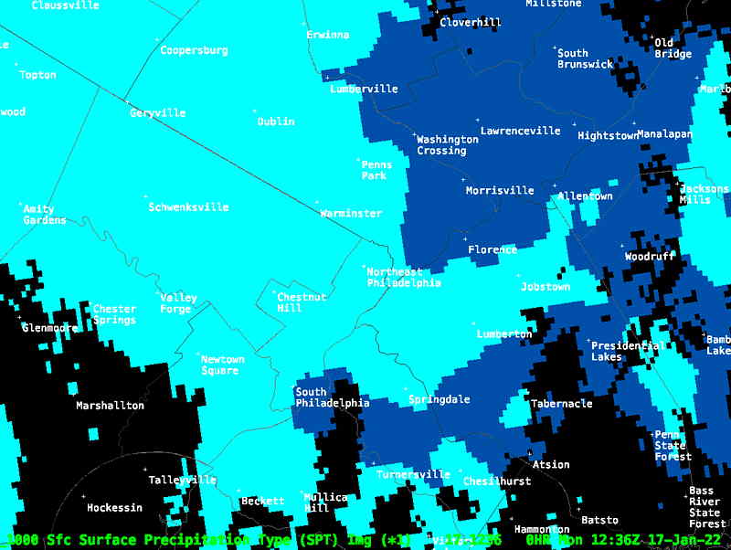
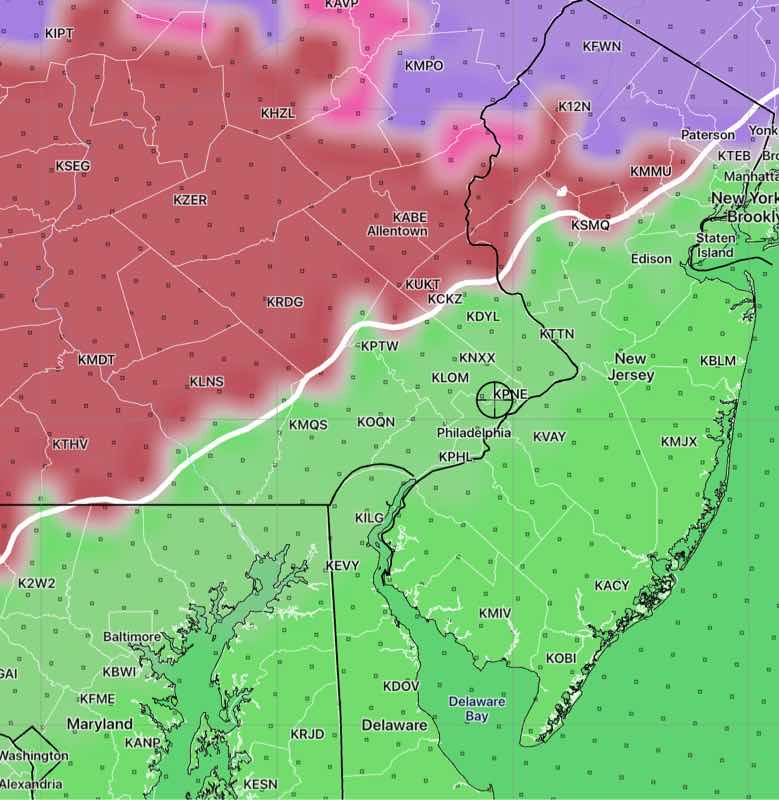
Some radar feeds incorrectly categorize what we’re getting as snow. The MRMS correctly shows what’s happening now—
MRMS current precipitation type. The blue color coding is misleading, suggesting snow. Snow is coded as white. The actual precipitation we’re getting is tagged “cold stratiform rain”. (Click on image for a larger view.)
Look for windy, cloudy conditions today, temps in the 30s.
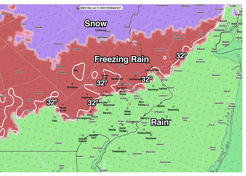
Update Sun @ 9:15 PM — Snow is changing over to rain. High winds possible after midnight. Temps wise to near 50 before falling back to the 30s. Rain ends before daybreak. Tonight’s models continue to forecast snow showers between 7AM and 11 AM Monday morning (mentioned in my 12:50 PM update today). Temperatures will be above freezing and little or no additional accumulation is expected.
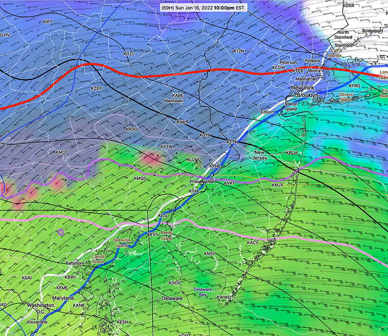
Update Sun @ 7:15 PM — The current radar precipitation type shows that the transition to rain is lagging about an hour or so from the model forecasts. The latest HRRR and RAP models still show the transition in PHL about 8 PM, but the actual transition time may be later.
The next new major model run is the 00z run. The 00z HRRR, NAM, RAP and HIRESW will be available by 9:15. I’ll update if necessary.
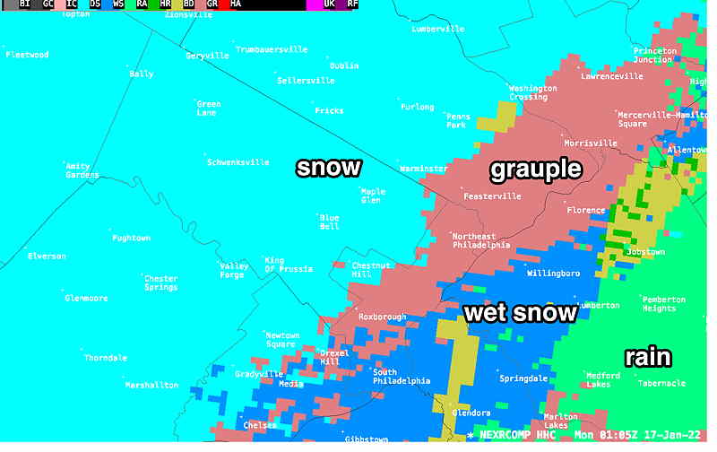
Current Radar Precipitation type at 8:05 PM Changeover seems to be happening in PHL. (Click on image for a larger view.)
MRMS Precipitation TYPE Snow is 40 miles southwest of Philadelphia at 2:45 PM (Click on image for a larger view.)
Update Sun @ 12:50 PM — This morning’s high resolution models (HIRESW) show considerable snow shower activity Monday morning with a wet coating possible.
Update Sun @ 8:03 AM — Last night’s 06z models continue with a generally earlier start and transition to rain. Clouds move in between 11 AM and 1 PM. Some snow possible as early as 5 PM, very rapidly changing to a period of freezing rain and then rain by 8 PM in the city and shortly afterwards north and west as temperatures rise above freezing. With heavy rain (1.25-1.5”) late evening, temperatures climb to 47º-50º around midnight. Strong wind gusts about 1 AM approaching 50mph.
Rain ends about 4 AM. Cloudy Monday, windy, temps above freezing in the 30s until evening.
Update Sat @ 9:30 PM — The major model runs are are done at 00z and 12z ( 7 PM & 7 AM EST). Some of the 00z high resolution models have become available. The changes noted in my previous update, with an earlier change to rain, are still expected. Some freezing rain possible about 8 PM.
Temperatures below freezing all day Sunday, will rise into the mid 40s after midnight! About 1.5 inches of RAIN will fall before it ends before daybreak Monday.
Update Sat @ 5:05 PM — This afternoon’s 18z models have become available. The trend is for the system to approach earlier on Sunday. Clouds increase by late morning. Some snow develops as early as 5 PM.
The warm-up also appears to occur 2 hours earlier with a transition to sleet and rain in the city around 8 PM and moving quickly north. By 10 PM, the HREF has mostly rain for our area —
HREF 18z Rain/sleet by 10 PM (Click on image for a larger view.)
By Monday morning, little if any snow will be left after the heavy rain.
Another slight change. Non-accumulating snow flurries/showers likely Monday morning and again late afternoon.
It looks like the coming week will be colder than average with another chance of sleet or snow on Thursday.
Update Sat @ 10:01 AM — The forecast for Sunday evening’s storm is essentially unchanged from the GFSforecast from this past Wednesday. While we still have plenty of time before Sunday evening, the models have done usually well with this storm forecast so far. There weren’t the usual differences among models we often see with winter storms.
The Sunday night period is within forecast range now of the very high resolution models.
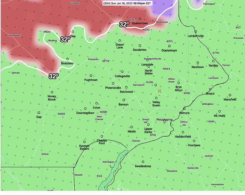
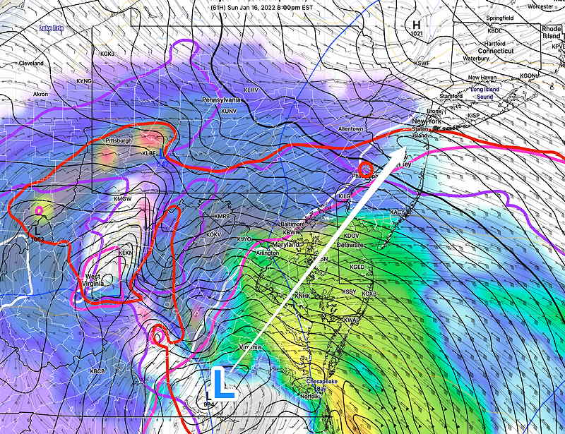
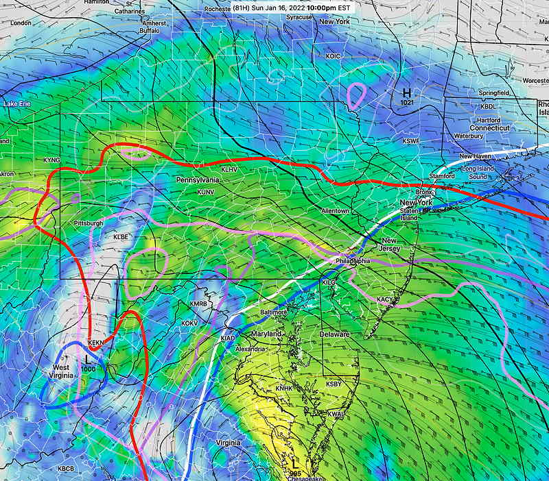
Snow starts at about 5-7 PM from south to north. Changes to rain most immediate suburbs by midnight. Here’s the latest HRRR with the snow-sleet transition line at 10 PM Sunday—
HRRR precipitation type (PTYPE) forecast for Sunday at 10 PM. The white contour (32º) is the surface temperature. The lavendar, blue and purple contours are the critical thickness contours. (Click on image for a larger view.)
Previously Posted Fri 5:23 PM —
Very cold air will move in due to the flow around a low pressure system (that missed us) in the Atlantic today.
A storm that is has been forecast since Tuesday to form near Virginia early Sunday will move northeastward across our area. We’ll be on the warm side of the storm.
While the model forecasts for this storm have been remarkably consistent, a possibility exists that a more prolonged period of freezing rain will develop in the very far northwestern suburbs Sunday night due to cold air damming. It should all change to rain during the pre-dawn hours.
Saturday
Embedded in the upper very cold flow is an upper air disturbance. Sunny early morning. Then we’ll have mid-level cloudiness from late morning through much of the afternoon. Very cold. High temperature will be 23.2º ± 2.1º (NBM model Blue Bell, PA). It will be very windy in the morning, but winds should subside in the afternoon.
Previously Posted Fri 5:23 PM —
Sunday
It will be sunny and very cold Sunday morning. Clouds move in about 1 PM. Snow starts between 5 and 7 PM and quickly mixes with and changes to rain about 10 PM. Up to an inch is possible before changing to rain. (Details have not changed since my earlier forecast.) High temperatures in the 20s during the day will rise to 39º by midnight.
The total QPF (quantity of precipitation falling) is predicted to be on the order of 1.25″ water, but only about 0.2-.0.3″ will fall as snow.
Some areas in the far-western suburbs may have a more extended period of freezing rain.
GFS forecast for Sunday at 8 PM. Snow falling will change to rain around 10 PM. Less than 1″ by midnight with a slushy, heavy compacted 1/2″ by Monday morning. (Click on image for a larger view.)NAM-NEST forecast for midnight Sunday showing “PTYPE” (precipitation type) The rain-freezing rain line will continue to advance northward. There is an outside chance that areas in far upper Montgomery/Bucks county may experience a longer period of freezing rain late Sunday night. (Click on image for a larger view.)
[/read]
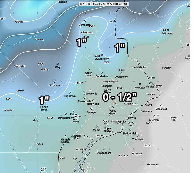
In the Philadelphia area and immediate surrounding counties, it changes to all rain. If you were to go out and measure the snow at midnight, you’d find maybe 1 inch of snow in the immediate PHL area, but with most of the precipitation expected to fall as rain after midnight, there will be about 0- 1/2 inch of heavy, slushy mess by the morning. Rain ends before daybreak.
Latest GFS (18z) with snow totals by Monday 8 AM. (Click on image for a larger view.)
Some snow showers possible during the morning. Temperatures do not go below freezing until Monday evening.
Considerable cloudiness Monday. Some snow showers possible late Monday afternoon or evening. Gusty winds in the afternoon.
Update Fri @ 10:47 AM — This morning’s GFS (12z) just available shows even less snow by the changeover time of about 10 PM— less than 1 inch. Even less will be left by Monday morning after a night of rain.
Update Fri @ 8:47 AM — Last night’s 00z and 06z model runs show little change in the forecast for Sunday into Monday. Snow starts between 5 and 7 PM Sunday and quickly mixes with and changes to rain about 10 PM, with a mix of sleet and rain, then snow far north.
NAM 06z showing critical temperature (snow/rain) contours (violet-blue-magenta) moving north of Philadelphia at 10 PM with a transition from snow to rain.
If you were to go out and measure the snow at midnight, you’d find maybe 1-2 inches of snow in the immediate PHL area, but with most of the precipitation expected to fall as rain after midnight, there will be about 1/2-1 inch of heavy, slushy mess in the morning.
While some of the ensemble models and NBM continue with a chance of showers or snow flurries during the day Monday, most deterministic models have the precip ending around daybreak.
All keep the temperatures above freezing Monday, so a freeze up is not expected until Monday night.
I’ll update later today if things change dramatically.
Of course, I’ll be updating the storm forecast with my regular weekly feature “Weekend Weather Forecast” Friday evening.
Update Thu @ 10:20 PM — Tonight’s NAM, just available, continues with the same forecast for Sunday evening into Monday. A transition to rain around Philadelphia about 10 PM.
Like the GFS, it has most of the precipitation (rain) ending before daybreak Monday. Likely snowfall is down to a soggy inch or so.
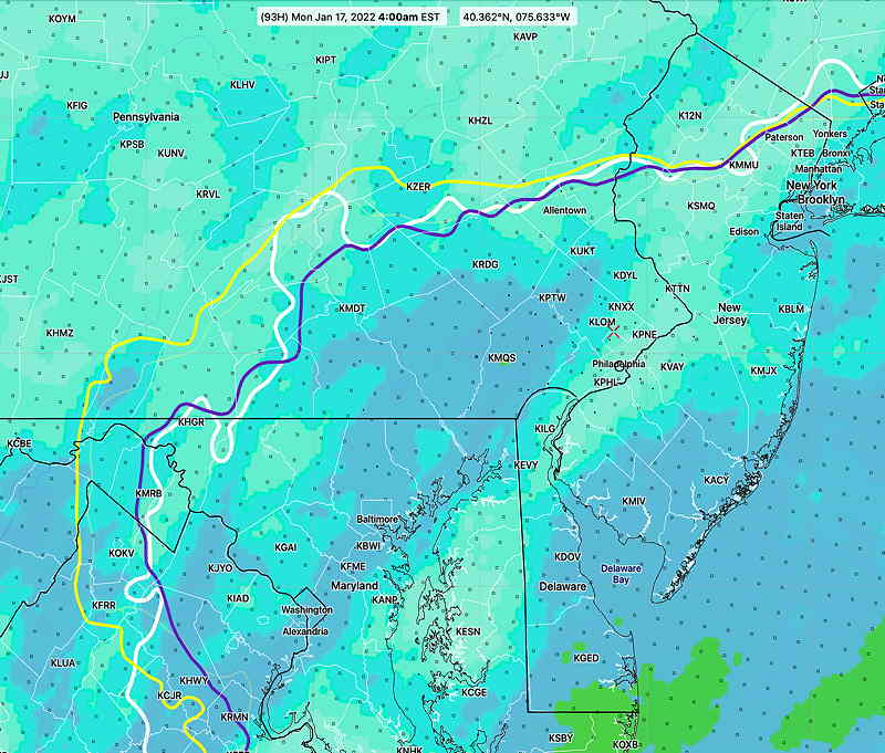
Tonight’s NAM rain/freezing rain/sleet/snow areas at 1AM Monday
Update Thu @ 5:10 PM — (some additional changes highlighted below.) The storm forecast for Sunday evening into Monday has just come into range of this afternoon’s NAM model which forecasts up to 84 hours ahead. While its forecast doesn’t extend into Monday, it shows what we can expect for the start of the storm.
The NAM supports a similar development and track that the GFS has been forecasting since Tuesday. Snow starts between 4 PM and 7 PM, but critical levels of the atmosphere warm up by 10 PM with transition to sleet and just rain by midnight.
NAM 18z forecast for Sunday evening 10 PM. The critical temperature contours will move north of the immediate PHL area starting 10 PM with a change to rain. Most of the storm’s precipitation will fall as rain.
While we might get snow (1-3 inches possible) before midnight, most of the precip with this storm is expected to occur occur between midnight and daybreak Monday with it too warm for anything but rain.
With heavy rain during the night, much of the snow will be compressed down to slush by morning.
The latest GFS has the storm exiting quickly, by early Monday morning with just snow showers.
It’s not clear whether there will be much snow on the back side of the system, but the trend is that there won’t be much.
It should be noted that the GEFS (ensemble) still maintains more of a coastal storm. So there’s a glaring lack of agreement with this storm. Things could change.
The storm expected late Sunday into Monday is expected to bring a mix of wintry weather to us. What most people want to know— “How much snow are we going to get?”
As is often the case with winter storms in Philadelphia, nailing down the snow totals is beyond challenging. This coming storm will likely be an extreme example of challenging.
It’s never a just matter of seeing where the 32º line surface temperatures is. The atmosphere is three dimensional and temperatures at several different layers of the atmosphere are associated with snowfall and other precipitation types.
There are several main techniques that snow / sleet / freezing rain / rain are forecast; basically they all try to figure out the average temperature of layers of the atmosphere: (hover on the underline for the pop-up glossary)
Average predicted 32º temperature at certain levels of the atmosphere, specifically 800, 900 and 975 mb ( NAM FOUS data)
Position of critical thicknesses, which in turn, are associated with average 32º temperatures . The 540 contour of 500-1000 mb thickness is the most basic, although there are other “critical” thickness levels associated with snow and other PTYPES.
Three dimensional temperatures energy referred to as Bourgouin Positive and Bourgouin Negative Energy areas, developed by the Canadian Meteorological Center. (Review the research paper at this link.) The model blend (NBM) includes the Bourgouin parameters.
Position of the 32º contour “average Wet Bulb Temperature above 610 meters above ground level”
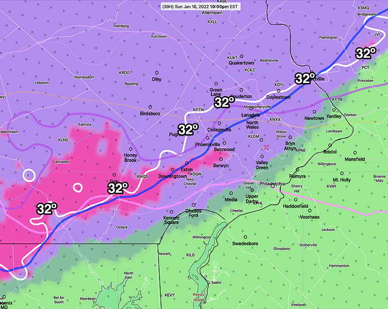
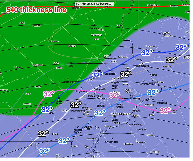
Below is the latest GEFS (mode) model with 32º contour temperatures at 800 900 and 1000 mb at 1 AM—
GEFS 06z forecast for Monday at 1 AM. 32º contours at different critical layers of the atmosphere suggest much of Philadelphia and half of Montgomery/Bucks county will be a mix of sleet and rain. Areas north of the blue 32º will be wet snow. Below this will be a mix and rain. “Guaranteed all snow” is near and north of the 540 thickness line“. Shading is six hour precipitation. (Click on image for a larger view.)
Here’s this morning’s NBM showing the Bourgoiun Positive Energy at 5. J/kg contour and the average Wet Bulb Temperature
Today’s NBM 12z for Monday at 4 AM is predicting a much ‘warmer’ storm with the yellow criticalBourgoiun contourfar north of the city. The wet bulb 32º contour is also far north of the city. (Click on image for a larger view.)
What makes this so difficult is that the predicted position of these precipitation type cut offs changes throughout the storm and and will change drastically with this storm. Calculating a snow total, including compaction of snow fallen by a change to rain is a moving target.
Currently I’m still leaning towards the warmer GFS model with less snow, as discussed yesterday. The GFS has us south of the 540 thickness line for much of the night time storm hour meaning rain or a mix.