Update Wed @ 9:03 PM — I’m going to need to change the title of this posting tomorrow to “Storm Late Sunday into Monday”.
This afternoon’s (18z) GFS and GEFS models have become available.
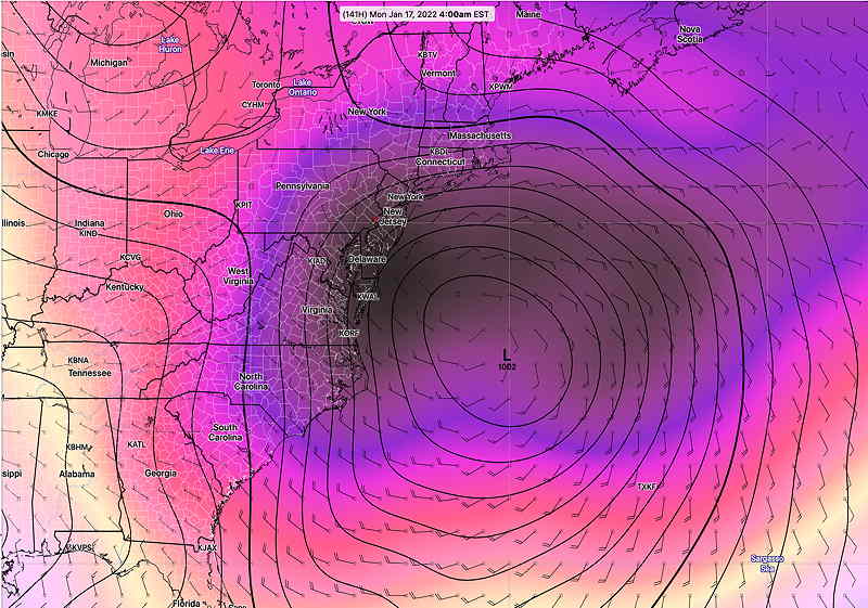
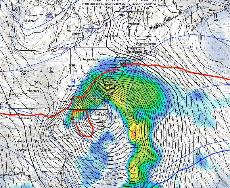
The GFS and ICON continue with a western track and a significant influx of warm air a few hours into the event. Any light snow at the start changes to sleet and rain and with a change back to snow possible but most of the moisture has move northeastward. So little accumulation in the immediate PHL area, according to the GFS.
Show More
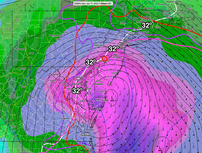
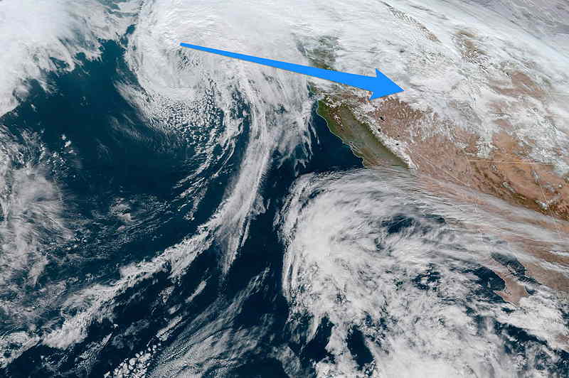
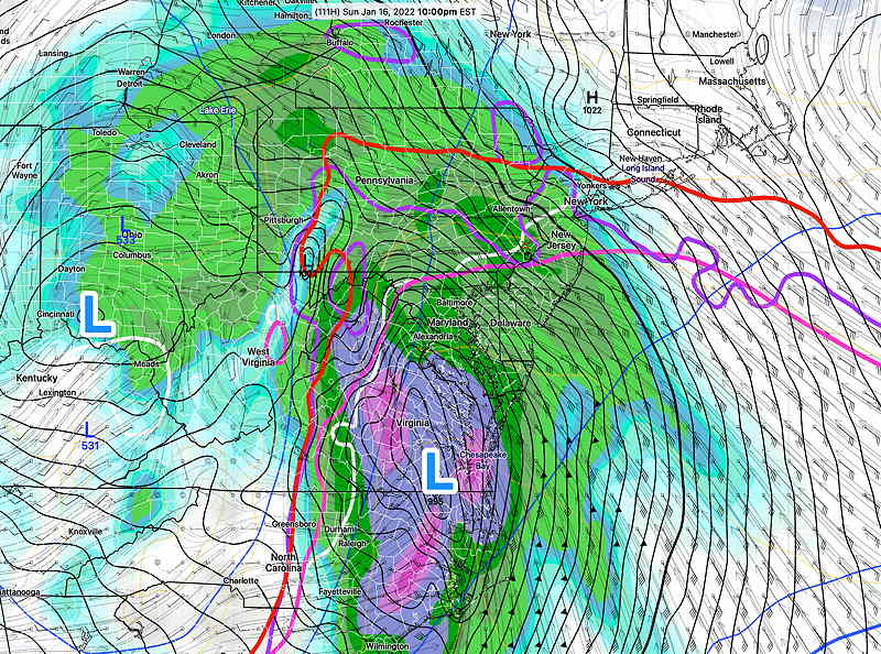
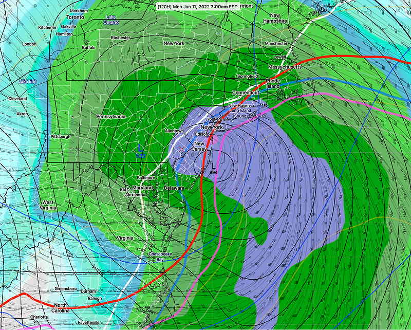
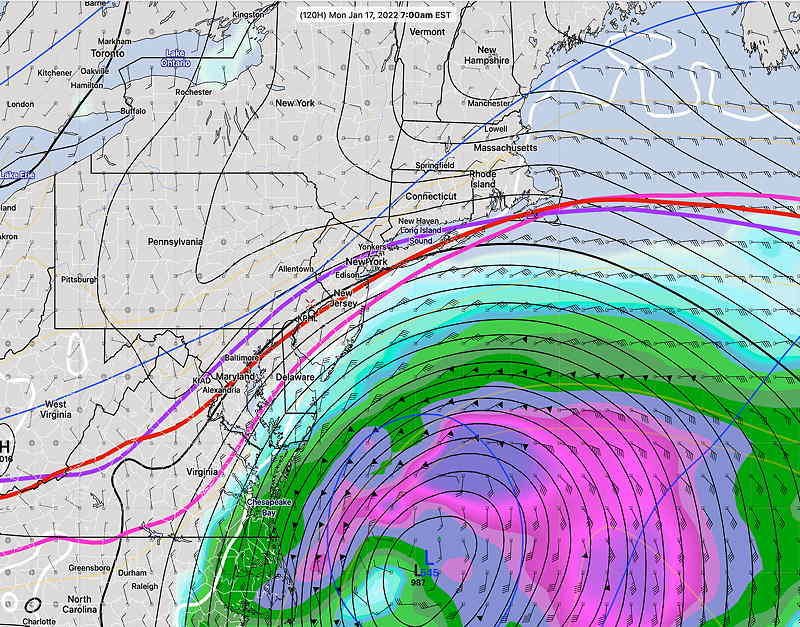
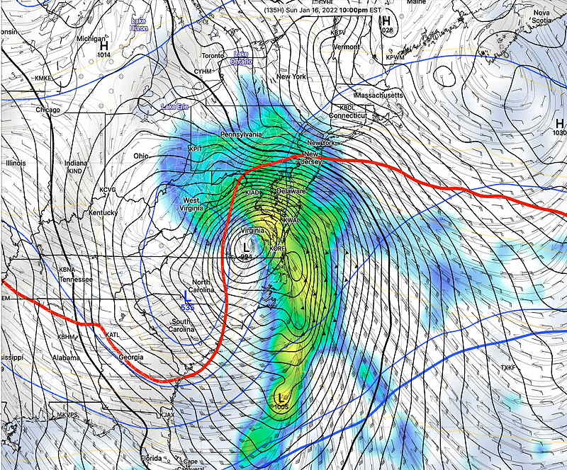
Unfortunately, this is going to be a complex storm and the above simple forecast isn’t supported by the ensemble versions- the GEFS. Both the ‘mean’ and ‘mode’ versions of the GEFS are now more similar, providing higher confidence in their forecast. They show a more coastal track with warm air moving in for a shorter period of time after 10 PM Sunday through 3 AM Monday. The thermal profiles are much more supportive of more snow accumulation— In terms of timing, the latest model blend (NBM) shows precipitation starting from south to north about 6-7 PM Sunday and ending late morning or early afternoon Monday. The NBM has a significant portion of the immediate PHL area in either rain or mixed precipitation. Way too early for snow totals, but tonight’s NBM (00z) snow totals for Blue Bell have a statistical range from 2.0″ -4.6″ by Monday afternoon. The storm comes into the forecast range of the NAM and Canadian RGEM models tomorrow. Stay tuned Update Wed @ 4:29 PM — While there’s still 110 hours before a storm affects us later Sunday, the models have trended towards a forecast first made by Monday night’s GFS. The storm will form from a disturbance that is currently in the eastern Pacific ocean right now— The GFS has a westward storm forecast: A deep low pressure system will develop over Virginia Sunday evening and will move northeastward over us later Sunday night into Monday. The storm will have an influx of warm air soon after the precipitation starts and the GFS’s inland track would assure we have mostly heavy rain and high gusty winds. My bet is on the GFS right now, since it was the first to predict this system and its been very consistent. Today’s European (ECMWF) model is similar to the GFS position. But its forecast of the storm exiting early Monday morning may be too fast. Unfortunately, the forecast isn’t clear cut, as the GEFS and ICON models have the storm moving over NJ or coastal NJ. (The ICON has measurable snow just northwest of the city.) These models also are much slower with the storm exiting the area Monday. Just to make things interesting, I’ll throw in another model, the Navy NAVGEM with its slower and eastern track which misses us. (I like the NAVGEM for tropical systems, not so much for winter storms) — Of course, there’s plenty of time for the forecast to change. The impulse that will create this storm is 3000 miles away at this time. Stay tuned. Update Wed @ 8:37 AM —The current trend with the forecast is for Sunday’s low pressure system to develop directly over our area, with any snow changing to a mix, then rain, and then back to snow before ending. The Canadian and European models are part of that general consensus, although the ensemble versions of the respective models continue to place it somewhat more eastward, as more of a coastal storm with the potential of more snow. According to the model blend NBM, snow will start about 4 PM Sunday and mixing and changing to rain about midnight and then transitioning back to light snow sometime late Monday morning or early afternoon before ending. The comparison of the GEFS ensemble mean vs. ensemble mode models show some differences in position and huge differences in the thermal profile, with the mean still showing snow here, but the mode too warm for much snow. Differences in the mean and mode models suggest a non-normal distribution of the ensemble members and higher uncertainty in the forecast. Since the storm is more than 89 hours in the future, we’re still dealing with the extended range and ensemble models and none of the higher resolution short range models. Stay tuned. Update Tue @ 7:52 PM — Today’s extended forecast models (GFS, Canadian GDPS, ECMWF and ICON) have all followed the lead of the GFS in predicting a near coastal storm Sunday evening into Monday. However, large differences/uncertainties in timing and placement of the center of the storm still need to be clarified in coming days. Currently, these deterministic models have a mixed bag of precipitation (snow/rain/freezing rain/sleet) for us due to a western track while the statistical ensemble models have more snow with an eastern track. Current timing is Sunday evening through Monday morning. The latest GEFS ensemble ‘mean’ (as in statistical average) model and the latest GEFS ensemble ‘mode’ model are similar, but are very different from the main GFS, confirming a low confidence forecast. The storm is forecast to affect us 132 hours from now. There’s plenty of time for things to change. Stay tuned. I’ll update tomorrow morning. Previously Posted Tue 1:26 PM — Following my long diatribe about extended range forecasting using ensemble models, another GFS model has come out this morning which supports the trend of a developing coastal storm from last night’s GFS— The latest Canadian GDPS, ICON and ICON-EPS have a similar forecasts, with some being too warm for snow here. As a followup to the ensemble forecast diatribe, the latest GEFS (12Z) has come out, which shows more of a snow storm with high uncertainty in the northwest quadrant— This is a developing situation. There’s much uncertainty, especially considering just 24 hours ago, this wasn’t a possibility. Stay tuned. Originally posted on Tue at 9:15 AM— The latest GFS has a new wrinkle, with yet another storm developing late Sunday into Monday. The GFS predicts this storm as a significant nor’easter with a mix of precip for our area. The latest GFS (below) is a statistical outlier, and NOT supported by the other models or its own ensemble. But it’s something to watch. Stay tuned.