NOAA and the National Weather Service announced today the upcoming release of a new GFS model version 16.3. The GFS model, our global deterministic model and our major model, will be upgraded from the current version 16.2.2 to version 16.3 on November 29th.
Version 16.3 will feature major enhancements in input data and significant corrections to snowfall accumulation forecasts (which have been over-forecast in warm situations and under-forecast in colder situations.)
Enhancements in data will include significant new input data as well as data refinements from satellites that input upper air winds, temperature and humidity measurements. Satellite radio occultation data will also be enhanced.
Several models (NAM, RAP, URMA, GDAS) use the same model assimilation input as the GFS. These models will also have their data input enhanced as of November 29th.
As NOAA often does, it has pre-released the new version 16.3 today and I will be using the new version going forward.
Tomorrow’s regular WEEKEND WEATHER FORECAST, will feature the new GFS and where interesting, I’ll compare its forecast to version 16.2.2
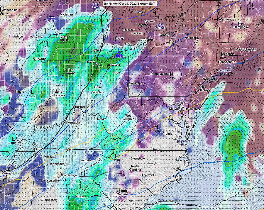
Example of forecast differences—
Current GFS Version (16.2.2) Forecast for Late Sunday night—
Current GFS version 16.2.2 Forecast for 2 AM Monday, showing rain and clouds. Notice the rain is off the New Jersey Coastline. (Click on image for a larger view.)
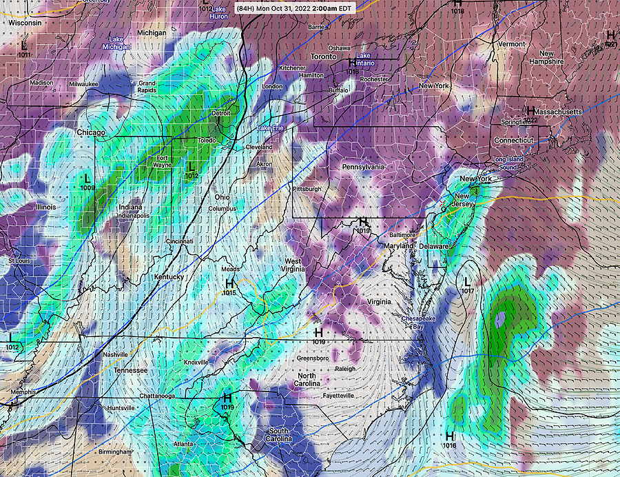
Compare to the new just released version GFS 16.3—
NEW GFS 16.3 forecast for 2 AM Monday. Notice this model version shows considerably more rain over NJ and into Philadelphia and low pressure is much closer to the coastline. (Click on image for a larger view.)
I guess I’m a true weather nerd; I get truly excited about a new weather model and the prospect of improved forecasts.
Of course, whether or not we’ll see an improvement in the forecasts, only time will tell. But I have incredible respect for the atmospheric scientists and true meteorologists at NOAA.
By the way, GFS version 17.0 is slated for the 4th quarter of 2024.
One reader wanted to know how to get the latest hourly probability of precipitation for our area.
One of the best ways is a direct link to the NBM (Model Blend) text output. The NBM is considered the best model for rain probability and the model data from this link is updated every few hours. (Yes, the NBM model is updated every hour, but to get the absolute latest, you’d have to dive into the bowels of the NOAA NOMADS server.)
I’ve pre-configured the URL for you to provide the model output for Philadelphia Airport, Wings Field Blue Bell, and Northeast Philadelphia airport—
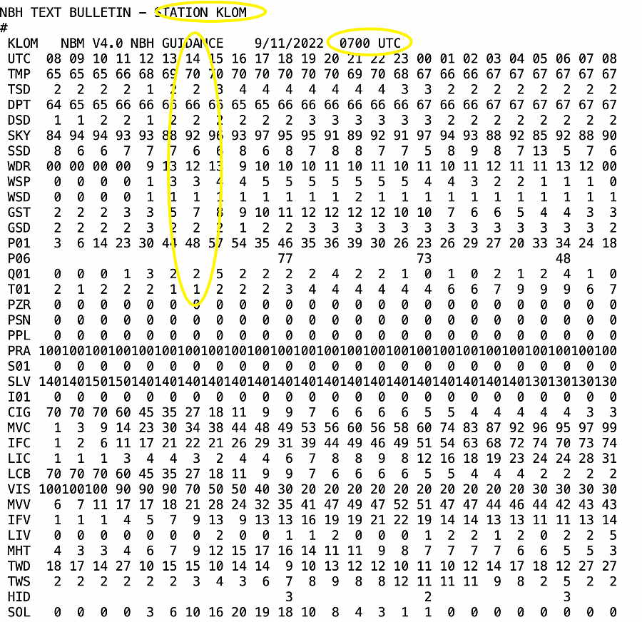
The one you want to focus on is the NBH ( H= hourly).
It provides hourly probability (P01) in percentage (on an hourly basis, anything greater than 18% and increasing is meaningful) and the amount (Q01) in hundredths of an inch.
It’s important to know, that with accumulated rainfall, the number refers to amount having accumulated in the preceding hour.
The tricky part is converting to the UTC time to Eastern Standard or Eastern Daylight time.
The example below is for KLOM, Wings Field, Blue Bell.
So in the example below, this is the NBM model run is from 0700 UTC (3 AM EDT). The first row (labeled UTC) are the forecast hours and the column labeled “14” is the UTC TIME forecast time. So 14UTC = 10 AM EDT (or 9 AM EST).
Looking down the 1 hour probability (P01) is 48% and the quantity of rain fallen in the preceding hour (Q01) is 2. 2= 0.02″
Beware that for some of the other data displayed, especially in the NBE, the meaning can less less than intuitive. In the NBE, the column labeled, as an example, 00 day FRI, refers to the 12 hours PRIOR to 00z Friday which means daytime THURSDAY!
Update Fri @ 10:47 AM — This morning’s GFS (12z) just available shows even less snow by the changeover time of about 10 PM— less than 1 inch. Even less will be left by Monday morning after a night of rain.
Update Fri @ 8:47 AM — Last night’s 00z and 06z model runs show little change in the forecast for Sunday into Monday. Snow starts between 5 and 7 PM Sunday and quickly mixes with and changes to rain about 10 PM, with a mix of sleet and rain, then snow far north.
NAM 06z showing critical temperature (snow/rain) contours (violet-blue-magenta) moving north of Philadelphia at 10 PM with a transition from snow to rain.
If you were to go out and measure the snow at midnight, you’d find maybe 1-2 inches of snow in the immediate PHL area, but with most of the precipitation expected to fall as rain after midnight, there will be about 1/2-1 inch of heavy, slushy mess in the morning.
While some of the ensemble models and NBM continue with a chance of showers or snow flurries during the day Monday, most deterministic models have the precip ending around daybreak.
All keep the temperatures above freezing Monday, so a freeze up is not expected until Monday night.
I’ll update later today if things change dramatically.
Of course, I’ll be updating the storm forecast with my regular weekly feature “Weekend Weather Forecast” Friday evening.
Update Thu @ 10:20 PM — Tonight’s NAM, just available, continues with the same forecast for Sunday evening into Monday. A transition to rain around Philadelphia about 10 PM.
Like the GFS, it has most of the precipitation (rain) ending before daybreak Monday. Likely snowfall is down to a soggy inch or so.
Tonight’s NAM rain/freezing rain/sleet/snow areas at 1AM Monday
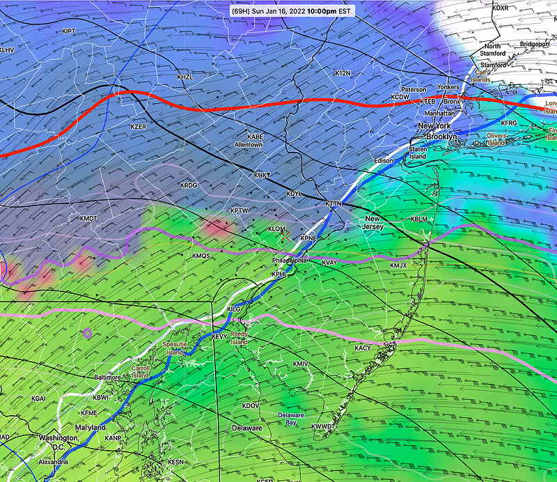
Update Thu @ 5:10 PM — (some additional changes highlighted below.) The storm forecast for Sunday evening into Monday has just come into range of this afternoon’s NAM model which forecasts up to 84 hours ahead. While its forecast doesn’t extend into Monday, it shows what we can expect for the start of the storm.
The NAM supports a similar development and track that the GFS has been forecasting since Tuesday. Snow starts between 4 PM and 7 PM, but critical levels of the atmosphere warm up by 10 PM with transition to sleet and just rain by midnight.
NAM 18z forecast for Sunday evening 10 PM. The critical temperature contours will move north of the immediate PHL area starting 10 PM with a change to rain. Most of the storm’s precipitation will fall as rain.
While we might get snow (1-3 inches possible) before midnight, most of the precip with this storm is expected to occur occur between midnight and daybreak Monday with it too warm for anything but rain.
With heavy rain during the night, much of the snow will be compressed down to slush by morning.
The latest GFS has the storm exiting quickly, by early Monday morning with just snow showers.
It’s not clear whether there will be much snow on the back side of the system, but the trend is that there won’t be much.
It should be noted that the GEFS (ensemble) still maintains more of a coastal storm. So there’s a glaring lack of agreement with this storm. Things could change.
The storm expected late Sunday into Monday is expected to bring a mix of wintry weather to us. What most people want to know— “How much snow are we going to get?”
As is often the case with winter storms in Philadelphia, nailing down the snow totals is beyond challenging. This coming storm will likely be an extreme example of challenging.
It’s never a just matter of seeing where the 32º line surface temperatures is. The atmosphere is three dimensional and temperatures at several different layers of the atmosphere are associated with snowfall and other precipitation types.
There are several main techniques that snow / sleet / freezing rain / rain are forecast; basically they all try to figure out the average temperature of layers of the atmosphere: (hover on the underline for the pop-up glossary)
Average predicted 32º temperature at certain levels of the atmosphere, specifically 800, 900 and 975 mb ( NAM FOUS data)
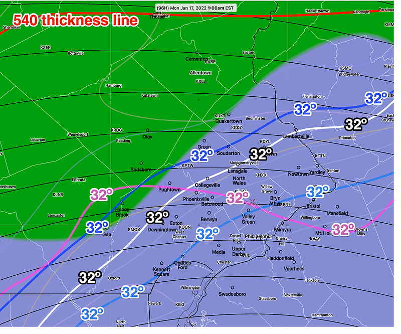
Position of critical thicknesses, which in turn, are associated with average 32º temperatures . The 540 contour of 500-1000 mb thickness is the most basic, although there are other “critical” thickness levels associated with snow and other PTYPES.
Three dimensional temperatures energy referred to as Bourgouin Positive and Bourgouin Negative Energy areas, developed by the Canadian Meteorological Center. (Review the research paper at this link.) The model blend (NBM) includes the Bourgouin parameters.
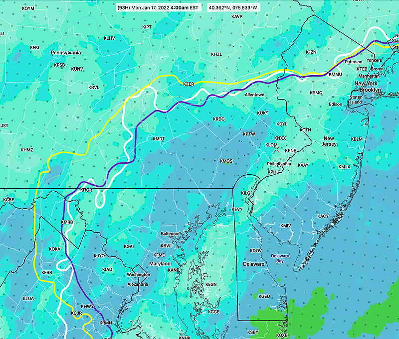
Position of the 32º contour “average Wet Bulb Temperature above 610 meters above ground level”
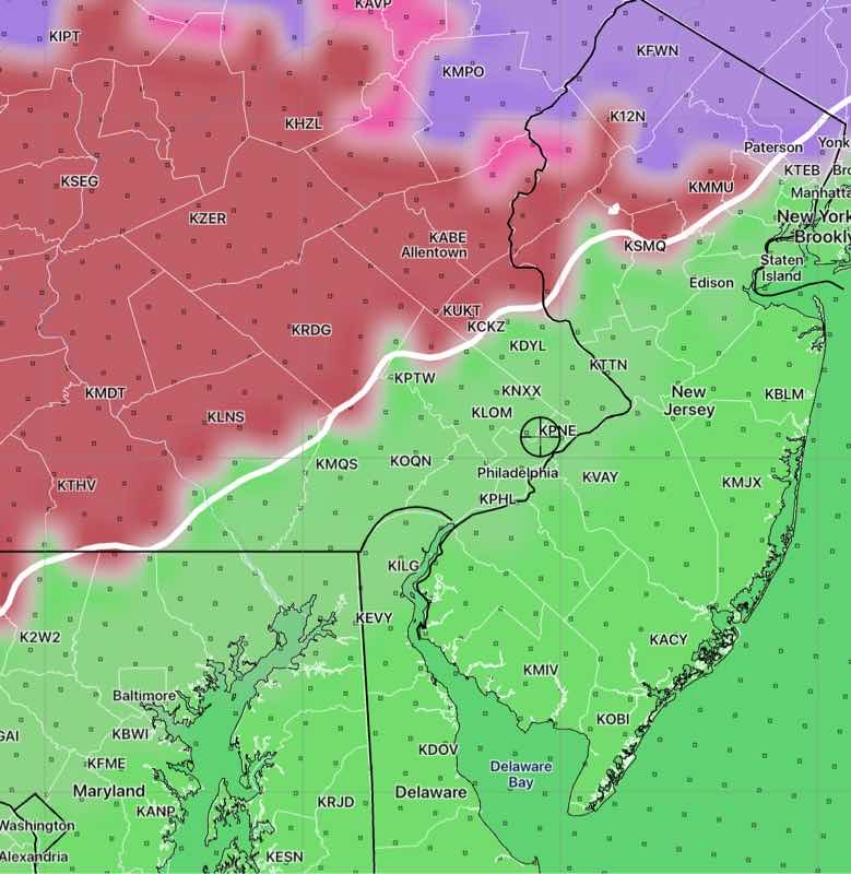
Below is the latest GEFS (mode) model with 32º contour temperatures at 800 900 and 1000 mb at 1 AM—
GEFS 06z forecast for Monday at 1 AM. 32º contours at different critical layers of the atmosphere suggest much of Philadelphia and half of Montgomery/Bucks county will be a mix of sleet and rain. Areas north of the blue 32º will be wet snow. Below this will be a mix and rain. “Guaranteed all snow” is near and north of the 540 thickness line“. Shading is six hour precipitation. (Click on image for a larger view.)
Here’s this morning’s NBM showing the Bourgoiun Positive Energy at 5. J/kg contour and the average Wet Bulb Temperature
Today’s NBM 12z for Monday at 4 AM is predicting a much ‘warmer’ storm with the yellow criticalBourgoiun contourfar north of the city. The wet bulb 32º contour is also far north of the city. (Click on image for a larger view.)
What makes this so difficult is that the predicted position of these precipitation type cut offs changes throughout the storm and and will change drastically with this storm. Calculating a snow total, including compaction of snow fallen by a change to rain is a moving target.
Currently I’m still leaning towards the warmer GFS model with less snow, as discussed yesterday. The GFS has us south of the 540 thickness line for much of the night time storm hour meaning rain or a mix.