THIS WEEK’S WEATHER

#Philadelphia #weather #PAwx

Friday and the Weekend

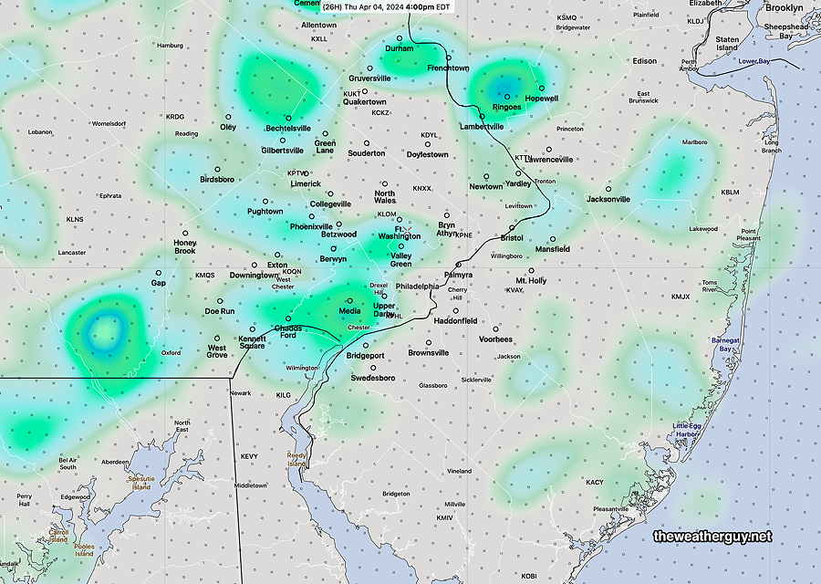
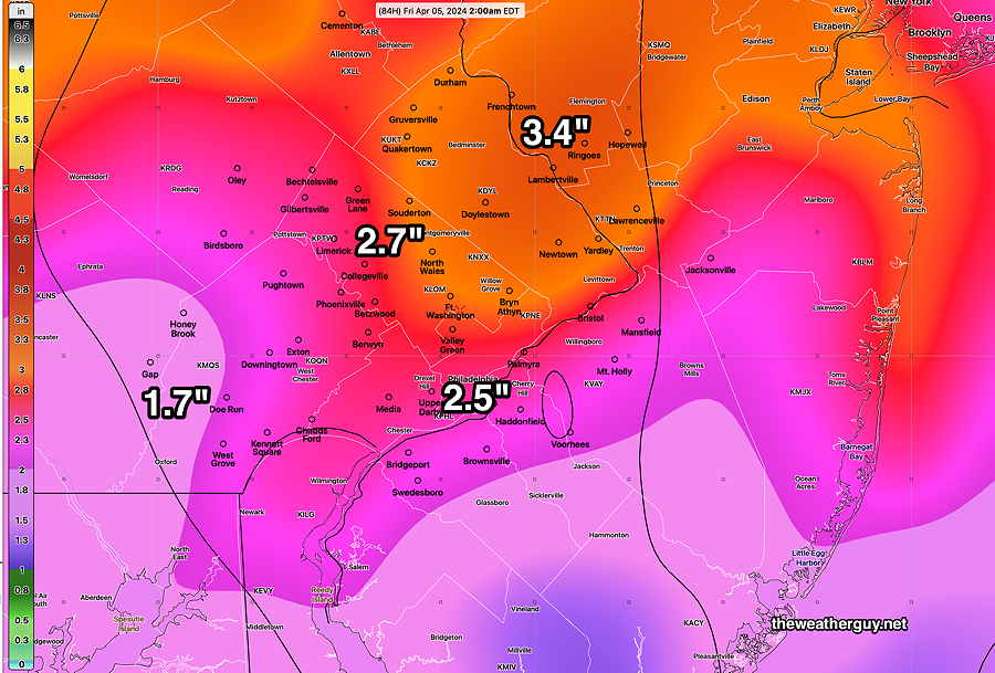
Posted Thursday 04/04/24 @ 5:35 PM — Showers developed in Delaware and Chester counties early Thursday afternoon and moved northeastward. The clouds and showers are the result of instability from cold air aloft and a cyclonic flow around the deep low pressure system that affected our weather earlier this week.

NAEFS forecast for Friday at 11 AM. Deep low pressure over Maine will continue to rotate cold, unstable air over us. (Click on image for a larger view.)

For Friday, the cold cyclonic flow will continue with sunshine in the morning and some sun with instability cloudiness in the afternoon. Showers may wait until evening to move in from the northwest. High upper 40s to about 50º

For Saturday, the effects of the deep low will slowly diminish. A mix of sun and clouds but a light sprinkle can’t be ruled out Saturday in areas far northwest of the city. Gradually moderating temperatures.

For Sunday, more sun than clouds, but some instability cloudiness still possible.


Wednesday night through Thursday

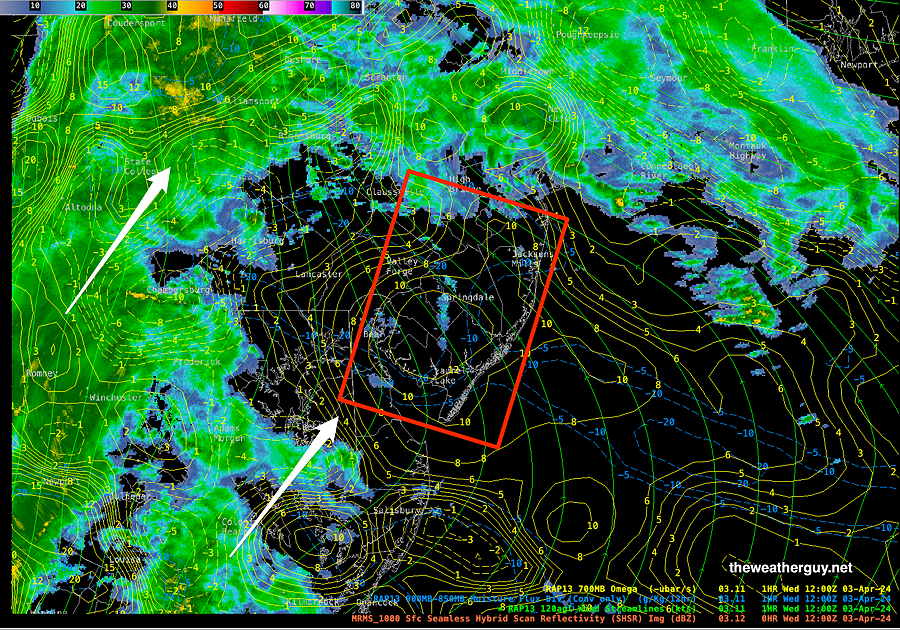
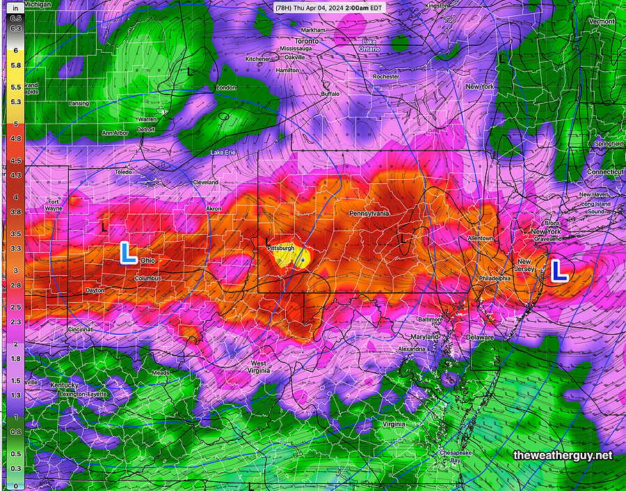
Posted Wednesday 04/03/24 @ 5:30 PM — We’ve had a lot of rain and we’re not quite done with it. Rainfall over the past 72 hours has been in the 2-4 + inch range —

MRMS combined rain gauge & radar-based measurement of actual rainfall received. Color shading is in inches. Line contour numbers are in mm (25.4 mm= 1 inch) (Click on image for a larger view.)

More showers tonight with the actual cold front moving through around midnight.

We may actually see some a bit of sun (with plenty of clouds) Thursday morning, but an upper air low will move directly over us resulting in thicker clouds and scattered showers developing early to mid afternoon—

HREF forecast 1 hour rainfall at 4 PM Thursday. (Click on image for a larger view.)

A similar scenario for Friday.


Wednesday Looking less Wild

Posted Wednesday 04/03/24 @ 9:02 AM — Last night’s models have backed off on the northern extent of the approaching warm front. That means that thermodynamic energy/instabliity (CAPE) will be significantly less than had been forecast, making thunderstorms and tornadoes less likely.

Vertical Shear and Helicity values remain highly elevated from 11 AM through the early afternoon. Since CAPE values are expected to be low, it’s unclear how that energy will come together into sensible weather. I would expect strong wind gusts during that period, along with heavy rainfall.

04-03-24 RAP model with current MRMS radar overlay at 9 AM. Very high upward vertical motion (yellow contours “Omega”) with blue contours (moisture convergence) will combine to produce heavy rainfall and strong wind gusts. (Click on image for a larger view.)

Wild Weather Wednesday

Update Tue 4/02 9:58 PM — Tonight’s models are increasingly forecasting the possibility of some severe weather Wednesday afternoon (3-4 PM) into the evening. This is especially true of areas from Philadelphia southward. Extremely high shear and helicity values coupled with moderate CAPE may allow some severe thunderstorms to form. High winds expected. Even tornadic activity is possible. Stay tuned.


Wednesday-Thursday Outlook

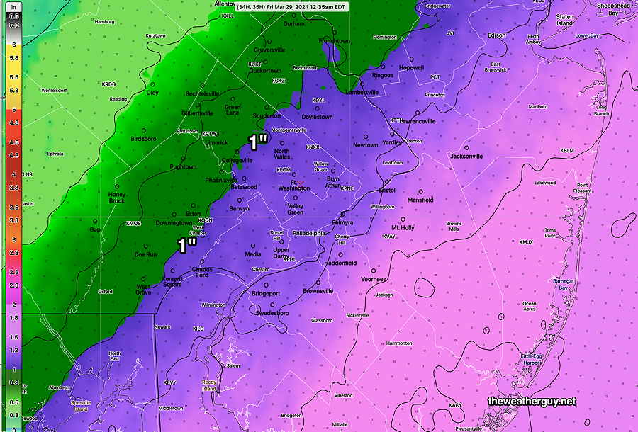
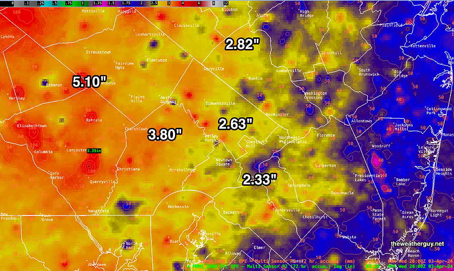
Posted Tuesday 04/02/24 @ 4:40 PM — I’ve been “doing the weather” for more years than I want to admit, but I don’t recall as many days of rain where 1-3″ accumulation has become the norm.

I’ve been able to access the MRMS rain accumulation data for the past two days, through 3 PM. (I’m not sure how accurate it is since the radar for Philadelphia, located in Fort Dix NJ, has been down for repairs.) —

MRMS combined rain gauge & radar-based measurement of actual rainfall received on Monday and today, Tuesday through 3 PM. Color shading is in inches. Line contour numbers are in mm (25.4 mm= 1 inch) (Click on image for a larger view.)

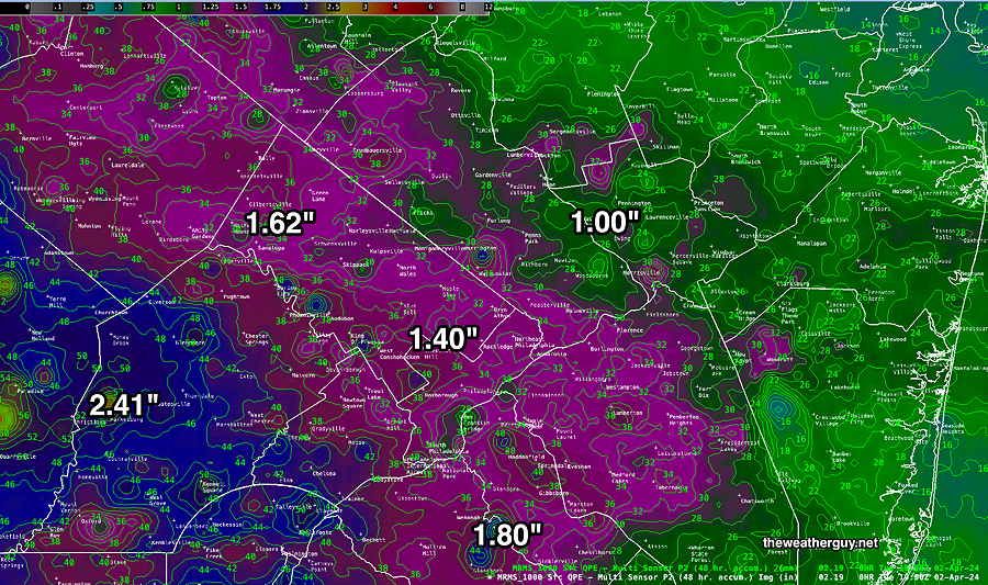
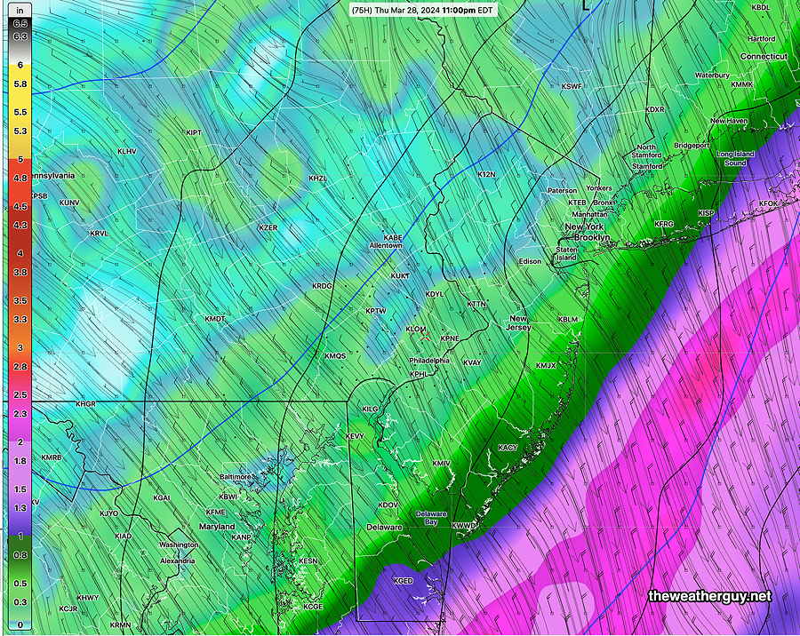
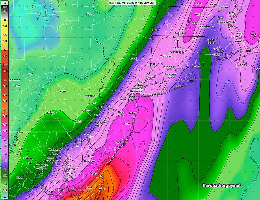
Additional rainfall, probably the heaviest of this week, will be on Wednesday as a warm front moves across. Perhaps another 1.5- 2″!

We had some low level thunderstorm activity Tuesday afternoon and the possibility exists for additional thunderstorm activity on Wednesday and especially Wednesday evening when thunderstorms may be moderate to strong as the cold front moves through.

It would not surprise me if a severe thunderstorm watch is issued for the period 5 PM through 10 PM Wednesday.

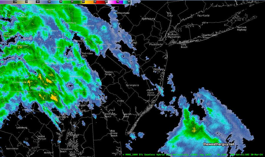
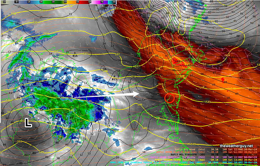
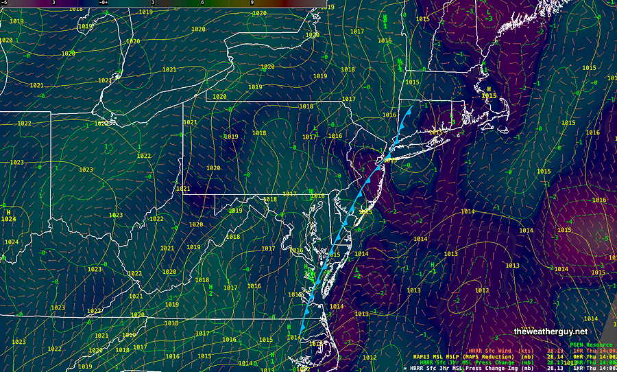
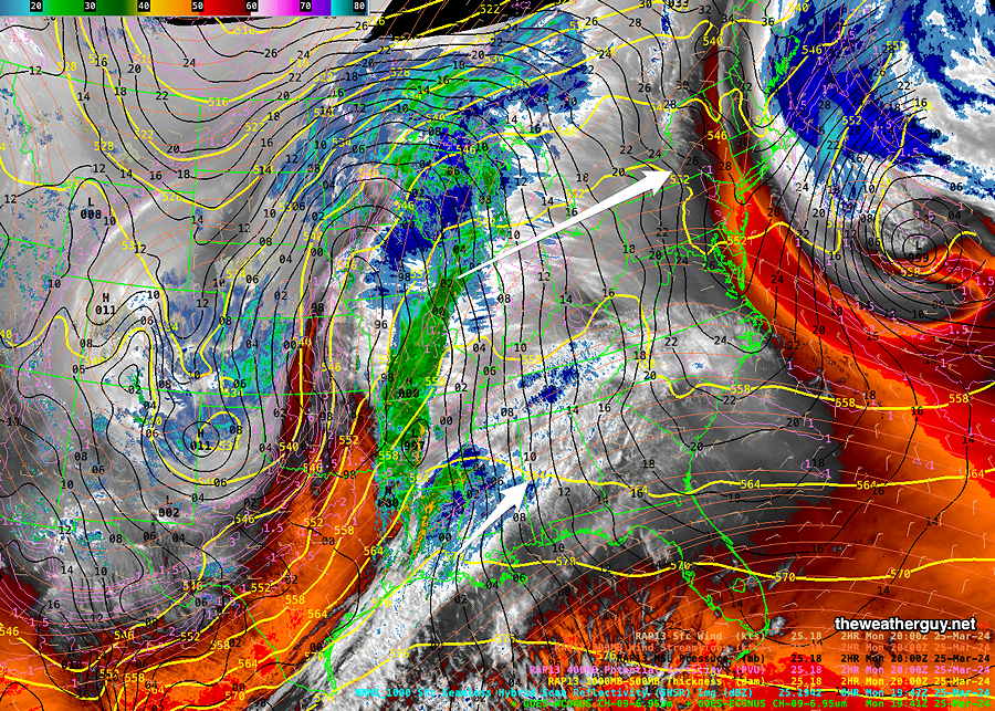
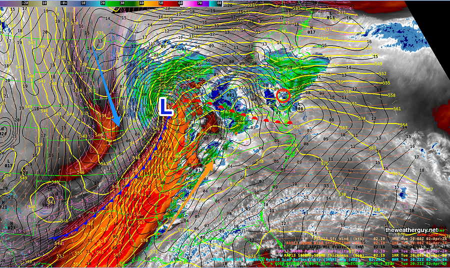
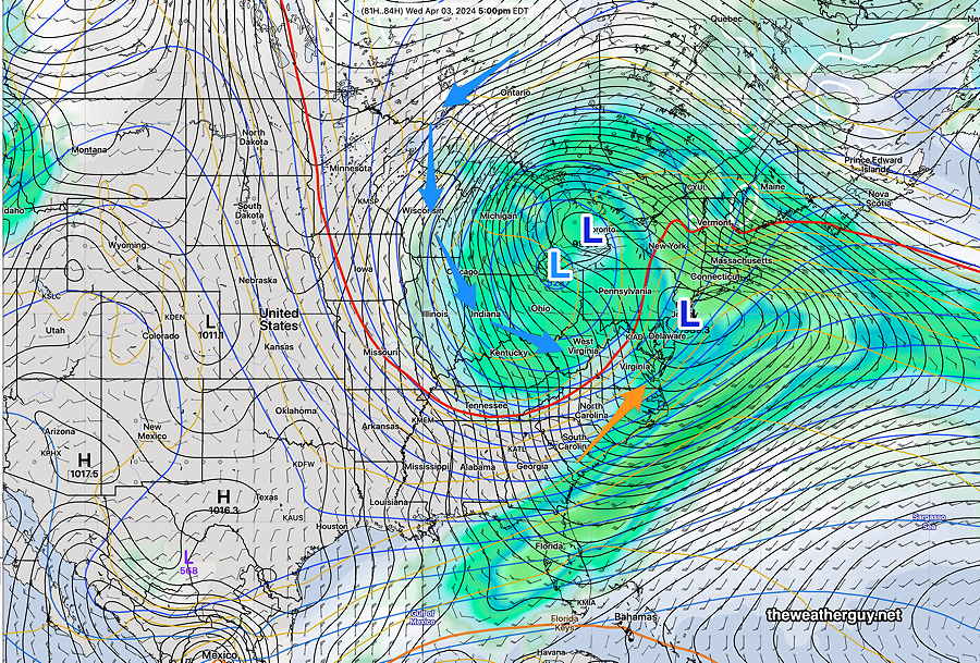
The latest water vapor image shows the current weather well—

Current satellite water vapor image with superimposed RAP model 500-1000 mb thickness lines (yellow), Mean Sea Level Pressure isobars (black contours) potential vorticity (fine violet contours) with superimposed MRMS RADAR. I’ve drawn in the warm front and cold front and indicated the influx of cold air behind the cold front (blue arrow) and the moist flow ahead (orange arrow) (Click on image for a larger view.)

Look for updates Wednesday morning if severe weather looks more likely.


Monday into Tuesday

Posted Monday 04/01/24 @ 7:50 PM — The forecast is unchanged. The latest GFS (which tends to slightly under-forecast rainfall) has 3 plus inches of rain by late Thursday.

Tuesday– An additional 0.8 -1″ of rain expected, especially north of the city.

Wednesday— Even heavier rainfall on Wednesday into Thursday.

By Friday—

04-01-24 18z GFS accumulated additional rain forecast from Monday night through 2 AM Friday. (Does not include Monday’s rainfall) (Click on image for a larger view.)

I’d like to post today’s rainfall, but the server I connect to is down.


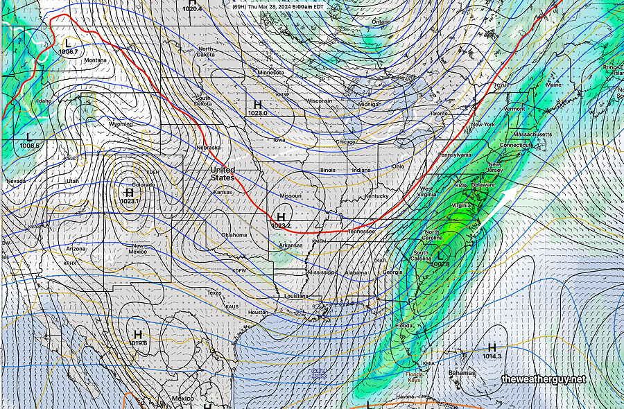
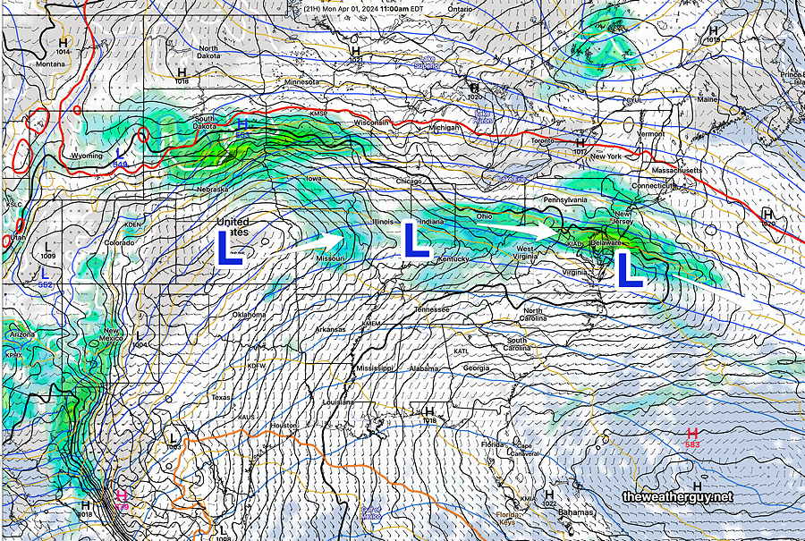
Posted Monday 04/01/24 @ 9:45 AM — Last night’s models continued with a little-changed forecast. Several low pressure systems will move through our area from today (Monday) through Thursday, culminating in a closed low over Ohio and a developing Nor’easter for New England off of our coast by Thursday morning—

04-01-24 00z ECMWF total accumulated rain forecast from Monday through 5 AM Thursday morning. (3.2″ in our area) The mid-level low (upper low) in L light blue will still be in Ohio on Thursday. As it tracks over our area Friday, we’ll still run the chance of showers. (Click on image for a larger view.)

The trend has been for slightly higher rainfall totals in our area (now over 3″ expected by Thursday.

As is almost always the case, the upper low will trail the surface low. The upper low will track over our area on Friday, still with a chance of showers and considerable clouds at times.


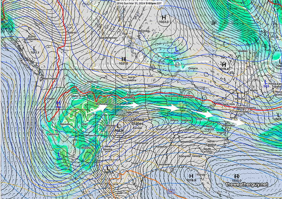
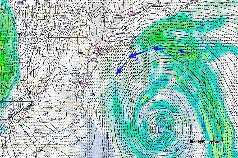
Originally Posted Sun 7:49 PM —A series of low pressure systems will move across the country into our area over the next few days. The latest GFS shows these disturbances—

Today’s 18z GFS forecast for 11 AM Monday shows several low pressure systems to affect our area this week. The first system will move somewhat south of us on Monday, with the heaviest rain staying to our south. (Click on image for a larger view.)

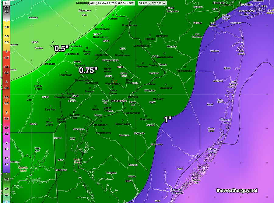
The first of these systems will bring rain to our area Monday. The trend has been for the heaviest rain to remain to our south. Rain starts about daybreak and continues through about 2-3 PM. Most of the immediate PHL area will get only 0.25″ to 0.35″ of rain, but areas in southern Chester and Delaware counties will have heavier rainfall.

The second two systems will merge into a deeper low that moves to the Great Lakes, bringing heavier rain Tuesday.

This same low will spawn a coastal low bringing rain again on Wednesday. An upper closed low will slow the departure of the Great Lakes low.

GEFS forecast for 5 PM on Wednesday. Coastal low shown. Great Lakes low with upper closed low (lighter blue) will maintain windy conditions through Friday. (Click on image for a larger view.)

A cold front moves through early Thursday.


WEEKEND WEATHER FORECAST

#Philadelphia #weather #PAwx

Sat 6:07 PM —Forecast Review —A few sprinkles moved in as early as 3:30 PM, earlier than I had forecast. The ECMWF was noteworthy as having predicted this. The main area of showers is poised to move in as originally expected after 6 PM. The showers appear to be somewhat heavier and further south than forecast.
MRMS radar image at 6 PM. Showers poised to moved in soon. (Click on image for a larger view.)

Saturday: A clipper system near the Great Lakes will move just north of our area this evening. Upper air support is not favorable for intensification and only very light showers will move in after 6 PM, mostly (but not exclusively) north of the Philadelphia area.

Before the light showers, cloudiness increases from the west, becoming mostly cloudy after 3 PM.

Here’s the current satellite water vapor image—

Current satellite water vapor image with superimposed RAP model 500-1000 mb thickness lines (yellow), Mean Sea Level Pressure isobars (black contours) potential vorticity (fine violet contours) with superimposed MRMS RADAR. Area of rain at 7 AM is 425 miles from here, corresponding well to the latest GFS forecast.

Here’s the latest HRDPS which is the most aggressive with the showers in our area—

Canadian high resolution 1 hour precip forecast at 7 PM. (Click on image for a larger view.)

Sunday: Periods of sun and clouds. Mild Showers move in during the late evening hours. High 63º

Rain moves in after midnight Sunday for a rainy Monday.


THIS WEEK’S WEATHER

#Philadelphia #weather #PAwx

Quick Weekend Outlook

Update Fri 3/29 11:16 PM — Too many things happening today, including a router malfunction and home electrical breaker issue. So no Weekend Weather Forecast in its usual form. Just want to say that the showers on Saturday won’t arrive until after 6 PM, despite what I’m hearing on TV.


Weekend Outlook Early Edition

Posted Friday 03/29/24 @ 9:48 AM — Today, Friday will be sunny and quite windy.

The first of a series of fast moving clipper disturbances will move across the ridge ridge (see yesterday’s graphic) to bring some light showers late Saturday.

WV image Friday morning shows the first of several clippers that will bring light showers Saturday evening. Another clipper and a warm front will bring a chance of showers and rain Monday through Wednesday. (Click on image for a larger view.)

We should see increasing cloudiness between noon and 2 PM Saturday. Light showers possible after 5-6 PM. High near 60.

Easter Sunday will have sunshine through high cloudiness. No rain. High low 60s.


Friday through Sunday Outlook

Posted Thursday 03/28/24 @ 5:51 PM

Thu 5:51 PM —Forecast Review — The models over-forecast the rainfall in Philadelphia today. A nose of dryer air kept rainfall to a minimum west of the Delaware river.

I guess the Phillies could have played today, but except for the wind, they’ll have a nicer day on Friday for their season opener.

Friday does look sunny, but very windy, especially in the afternoon. Highs 54º Blue Bell, 57º Philadelphia.

Saturday looks partly to mostly sunny, less wind. There may be a period of cloudiness early afternoon. Some clouds move in again towards evening with showers possible in the mid evening. Some models have these showers staying to our north.

A series of disturbances moving across a somewhat stationary upper air ridge will begin to affect our weather beginning Sunday. Here’s the NAEFS forecast for Sunday—

NAEFS model statistical “mode” version with overlayed GEFS model “bias-corrected” precipitation forecast for Sunday. Disturbances moving over the upper ridge may bring unsettled weather late Sunday through Wednesday (Click on image for a larger view.)

An approaching disturbance will bring a mix of clouds and sun on Sunday. The current forecast has showers moving to our south later Sunday, but this could change.


Thursday Update through Saturday

Posted Thursday 03/28/24 @ 11:01 AM — Current surface analysis shows a stalled front just through Philadelphia with waves of low pressure developing along the front—

Current Surface Analysis with Mean Sea Level pressure, surface winds and surface 3 hour pressure delta (HRRR) I’ve drawn the cold front’s approximate position. (Click on image for a larger view.)

It appears that the eastern track forecast for the heaviest rainfall from this system was the most accurate, and additional rainfall through this afternoon is expected with it being considerably heavier along the Jersey Shore and east of Philadelphia.

The rain tapers off between 4 and 6 PM from Philadelphia westward. Here’s the latest NAM-NEST at 5 PM Thursday—

03-28-24 12z NAM-NEST 1 hour accumulated rainfall at 6 PM (Click on image for a larger view.)

For Saturday, a clipper-type system will bring considerable clouds and showers late—about 6 PM according to some models and a bit earlier, late afternoon, according to some other models.


Thursday Forecast Update- Phillies Opener Rescheduled

Posted Wednesday 03/27/24 @ 5:18 PM — The rain came in slowly on Wednesday, but by 3 PM, most areas from Philadelphia westward were getting rain from this developing coastal system.

Phillies Opening Day has been rescheduled due to the wet forecast. The model trends over the past day have the heavy rain shield even further westward again, with rain likely all day Thursday and well into Thursday evening. The heavy rainfall totals forecast has increased. Here’s the latest NBM

03-27-24 18z NBM total accumulated rainfall Wednesday into Thursday. (Click on image for a larger view.)

Wednesday Thursday Update

Posted Tuesday 03/26/24 @ 10:14 PM — It looks like light scattered showers slowly move move in from the west on Wednesday, as early as 11 AM but most likely between noon and 3 PM. Rain coverage increases but there may be a lull during the evening until about 3 AM Thursday morning.

Scattered rain through Thursday, much heavier near the Jersey Shore.

The models are converging on a more eastern track for the heavy rain axis. In the city and west, it will be less than 1″. Heavier rain east and at the shore.

Here’s the current GFS forecast rain accumulation through Thursday —

03-26-24 18z GFS rain accumulation through Thursday. Contours are 0.25 inch increments (Click on image for a larger view.)

It’s not looking great for the Phillies opening day.


Tuesday Update

Posted Tuesday 03/26/24 @ 8:04 AM — Last night’s models have less cloudiness from Philadelphia and westward this morning. Thickening clouds still expected during the afternoon.

For Thursday, there’s a range of model forecasts regarding the heavy rain banding. The majority of the models keep the heaviest rain east into NJ and even further eastward. The GFS maintains heavy rain into Philadelphia—

Here’s the latest ECMWF—

Last night’s ECMWF shows the heaviest rain in the Atlantic. (Click on image for a larger view.)

Here’s the latest GFS—

03-26-24 06z GFS accumulated rain forecast by Thursday 10 PM (Click on image for a larger view.)

For last Saturday’s rain, the GFS also had a consistently westward track and was correct, but it had support from other models. This time, the GFS is the most westward. Updates later.


Tuesday

Posted Monday 03/25/24 @ 7:49 PM — A stationary area of low pressure in the western Atlantic will rotate clouds into our area on Tuesday. An approaching cold front will be here on Wednesday.

GFS forecast for 5 AM Tuesday shows a stationary vertically stacked low in the Western Atlantic. Moisture around this low will rotate into our area from the east on Tuesday. A high pressure ridge over our area will block precip from the west and east. The precipitation from the cold front is visible in the western sections of Ohio. (Click on image for a larger view.)

Tuesday -An easterly wind and thickening clouds during the day. Highs 51-53º but high uncertainty with a high NBM standard deviation of ± 3.5º

Some showers move in from the west on Wednesday, but rainfall totals look light.

Incredibly, the models are trending towards another 1″ + rainfall on Thursday, especially for NJ.


Overview

Originally Posted Mon 3:08 PM —Following Monday’s delightfully sunny but cool weather, the week ahead will be cloudier with several systems expected to affect us.

Here’ the satellite current water vapor image—

WV image Monday afternoon. A cold front in the Midwest will have its energy shear off to our north as it passes through Wednesday into Thursday, bringing showers. Low pressure is expected to develop along this front and will bring some rain to our area Thursday, but the main system will be slightly to our east. (Click on image for a larger view.)

A cold front in the Midwest will have its energy shear off to our north as it passes through Wednesday into Thursday, bringing showers. Low pressure is expected to develop along this front and will bring some rain to our area Thursday, but the main system will be slightly to our east.

Here’s the current GEFS forecast for Thursday—

03-25-24 12z GEFS forecast for early Thursday morning. Low pressure will move slightly east of our are, but some rain is still expected here. (Update: latest models Monday show possibility of 1″ rainfall. )( Click on image for a larger view.)