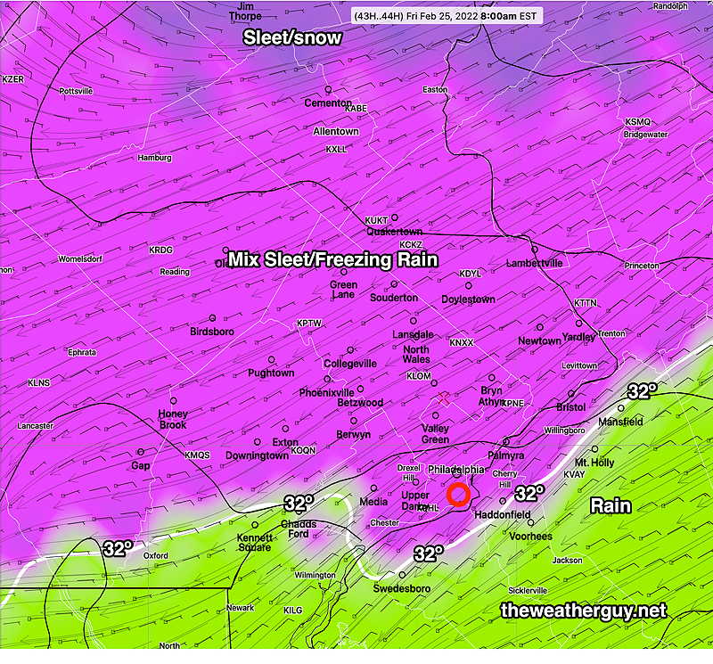
MIXED SLEET/FREEZING RAIN THURSDAY NIGHT CHANGING TO ALL RAIN BY MORNING
While the changeover to rain occurred, there was continued ice accretion past the rise in air temperatures above 32º. Most of the models over-predicted the rate of temperature rise. The major global models (GFS, ECMWF) never showed the temperatures drops into NJ.
Show More
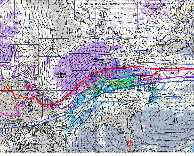
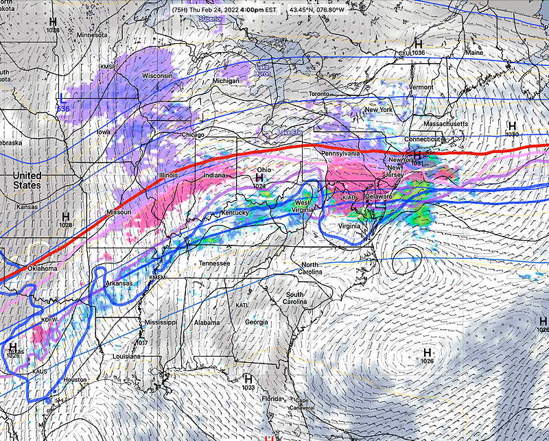
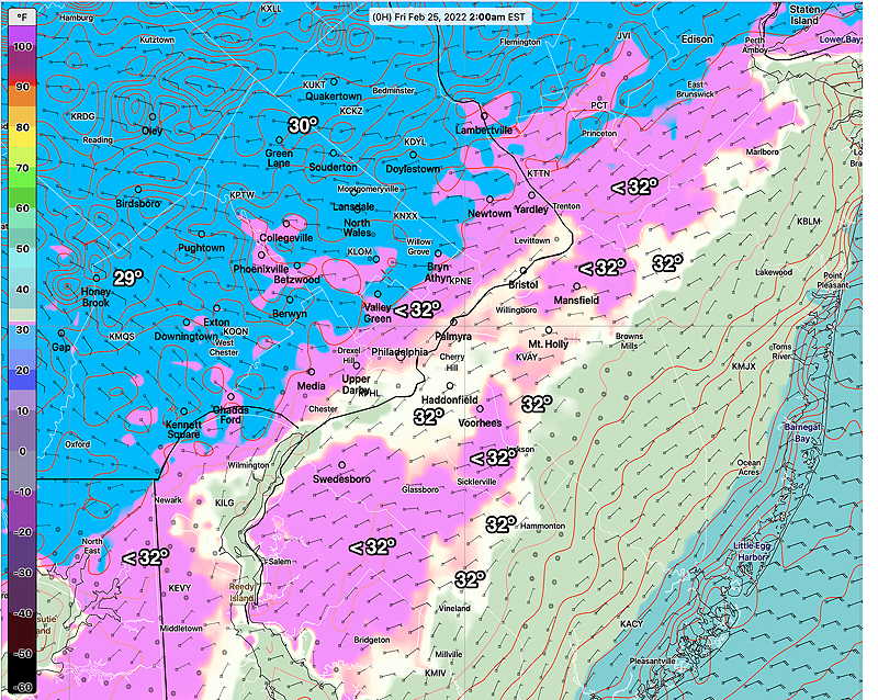
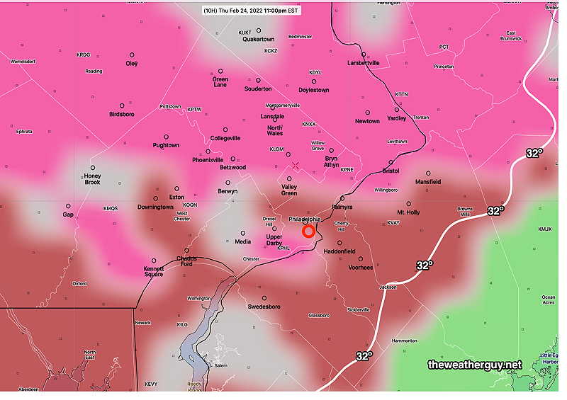
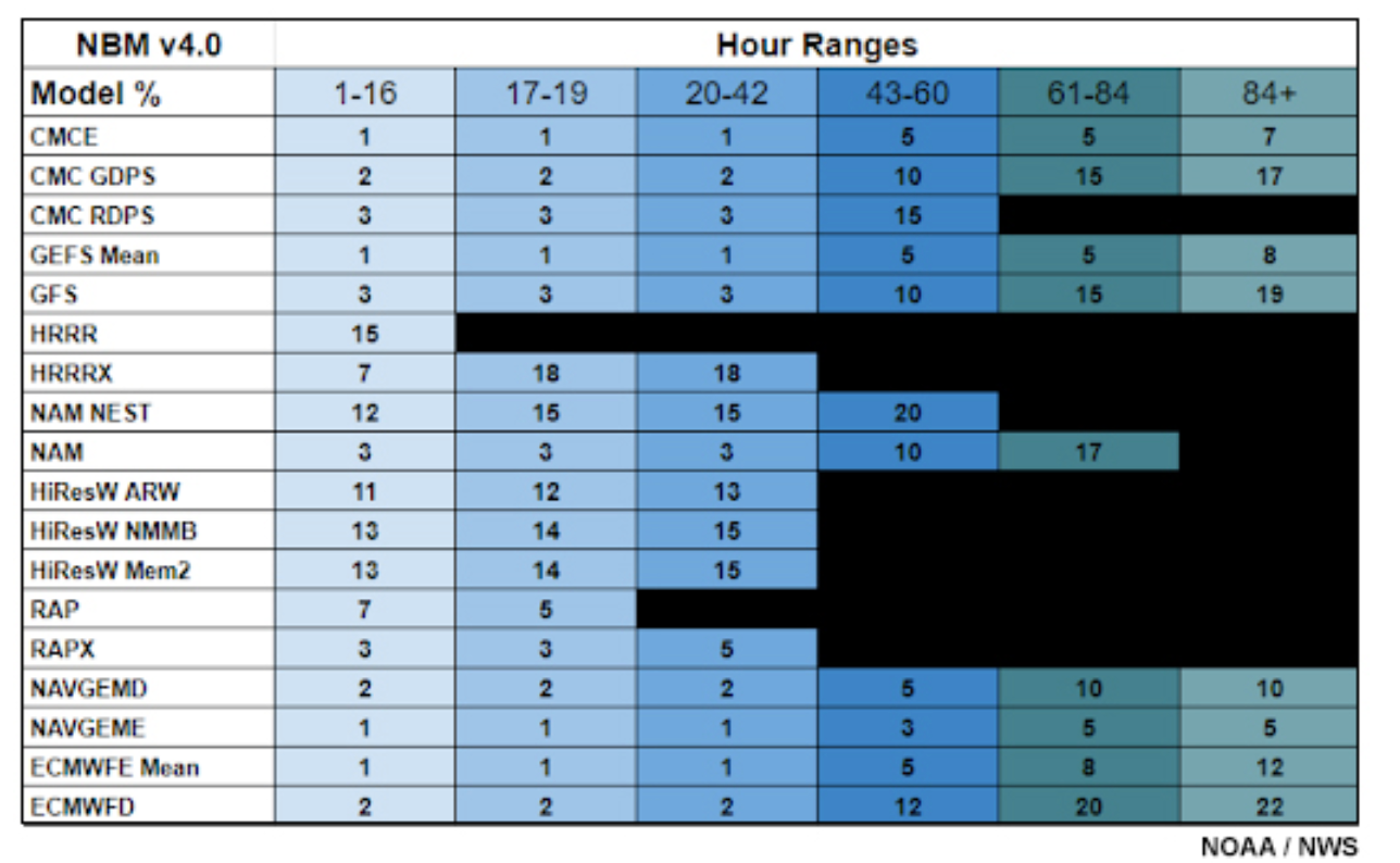
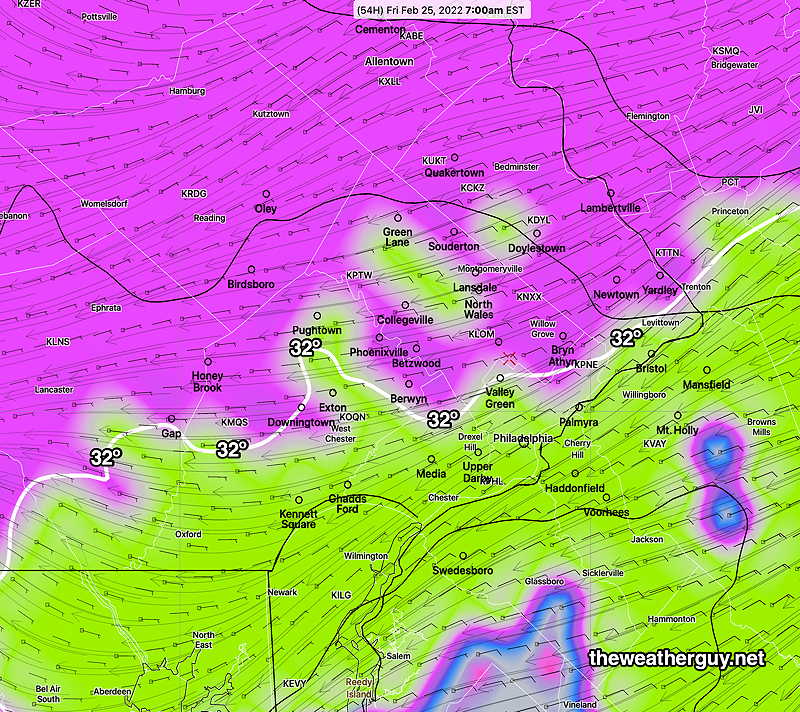
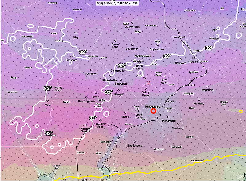
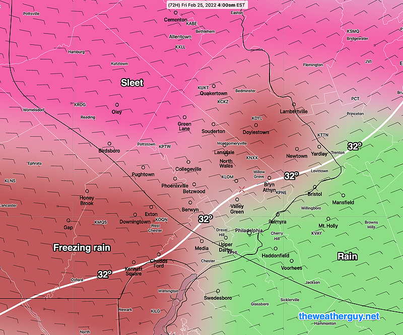
Update Thu @ 9:55 PM — The precip is developing and moving in as forecast. Insignificant forecast changes with tonight’s models. Rain may linger until late morning. Update Thu @ 5:54 PM — Here’s the latest trends based on today’s models. The trend is for some freezing precipitation to occur further southeastward than previously forecast (see image below). The changes are italicized: Update Thu @ 9:27 AM — Here’s the latest trends which are consistent with last night’s forecast: Latest HRRR showing the greatest extent of the icy precipitation southward at 1 AM Friday. By 2 AM, the HRRR has the icy precip moving northward and all rain by 7 AM in our area. This morning’s NAM-NEST and HIRESW models are colder and have the extent of the mixed frozen precip falling as far southward as the Delaware River. I think the NAM-NEST may be too cold and I’m sticking with the HRRR forecast above. All models forecast a change to rain by 7AM. Update Thu @ 8:02 AM — Last night’s models continue with a rapid warm up of the lower atmosphere between 3 and 5 AM. Any mixed icy precipitation will change to all rain by 7 AM in most of the immediate PHL area. The Canadian RGEM has joined the pack with a warmup. Update Wed @ 9:25 PM — Tonight’s models have an area of mixed precipitation moving through in the early afternoon in advance of the main bolus later in the evening. Update Wed @ 6:02 PM — Most of today’s models have continued with the following trend— The HRRR, NAM-NEST, HREF are on board with this warmup towards daybreak. There’s one fly in the ointment: The Canadian RGEM (which has done the best with recent transitions from rain to snow behind cold fronts) is showing significant “cold air damming” and delayed transition to all rain. It shows freezing temps at 8 AM. Here’s the latest RGEM forecast for 8 AM Friday— I’ll be interested to see if this trend holds and whether the RGEM had the right forecast. By the way, I recently came across a table that shows which models the NBM weighs more heavily in determining precipitation type (rain/snow/sleet/freezing rain)— Update Wed @ 10:08 AM —The forecast period is now in the range of the higher resolution models. The concern about icy conditions early Friday morning appears to have somewhat abated as the latest models show less cold air at night and a more rapid warm up by daybreak Friday. While the models are still predicting several hours of sleet mixed with rain in some of the area late Thursday evening into Thursday night, the trend has been to forecast a rapid increase in temperatures above freezing by daybreak Friday in much of the area. The latest HRRR model and shows sleet and freezing rain at 1 AM in the northern and western suburbs. These same areas are ALL rain by 6 AM, according to the HRRR. I’m leaning towards the warmer HRRR. The Canadian RGEM model (the model recently upgraded and improved in December) has done very well this year with cold front transitions of rain to snow. It has a colder, icier forecast, but still with a transition to rain about 7 AM close to the city— I’ll continue to follow this… Update Tue @ 8:40 PM —Today’s models show the following trends— Areas of concern are north and west of the 32º freezing surface temperatures (white contour)— I suspect things might change. I’ll update tomorrow Update Tue @ 8:51 AM — Last night’s models continue with the forecast of sleet, freezing rain and rain mix for much of our area, starting Thursday evening and changing to rain Friday early to mid-morning, with a changeover delayed in far northern suburbs. Some significant ice buildup is looking possible in northern and western suburbs by daybreak Friday. Stay tuned. Update Mon @ 7:52 PM — The latest ICON model (below) shows the complexity of the storm expected to develop Thursday into Friday morning. Heavy precipitation is currently predicted by all models, especially far northern suburbs. The latest NBM and GEFS are trending warmer, which would reduce the chance of heavy ice or sleet buildup. Update Mon @ 5:37 PM — A possible significant ice/sleet storm is setting up for late Thursday into Friday. A cold front will move through the area Wednesday dropping our high temperatures back to near and below seasonal levels. The front will stall not far to our south. Cold high pressure will set up to our north behind this front, while the southern branch of the jet stream brings very moist air into the mix. This arrangement is referred to as a classic “cold air damming” setup — cold air remains at the surface and is slow to retreat due to strong high pressure to the north, while warm moist air forced to ride above the cold surface layer at 3000 -5000 feet causing mixed ice and sleet type precipitation. The models are notoriously poor at predicting the warm up at the surface in these setups; they often predict warming too early, under-predicting the ice and freezing rain. The latest NAM is fast with the sleet (and briefly snow) moving in. It has some frozen precip as early as Thursday afternoon. Today’s ECMWF has significant precipitation falling in our area Thursday night while temperatures at the surface are below 32º. Not a good situation. The current model blend (NBM) is warmer with temps above freezing, posing less of a threat for an ice storm in the immediate PHL area. I’ll keep an eye this. Stay tuned. Previously Posted Sun 4:54 PM — A warm up is expected Monday in advance of a moist southerly jet flow with rain on Tuesday as another deep low forms over the Great Lakes area in response to phasing northern and southern jet streams— Following rain on Tuesday, Wednesday will initially be mild temperature-wise, but somewhat colder air will filter in late Wednesday. Another storm is expected late Thursday, although the timing is uncertain; some models have this next storm moving through Friday. The Thursday/Friday storm will be rain for us, but the rain-snow line will not be that far to our north— Very cold weather again next weekend.


![]()