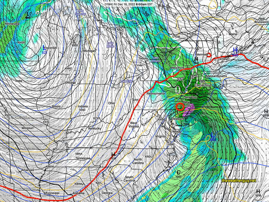
It’s still raining in many places at 10 AM and the rain is expected to end around noon. Cloudiness should diminish from south to north about 2-4 PM.
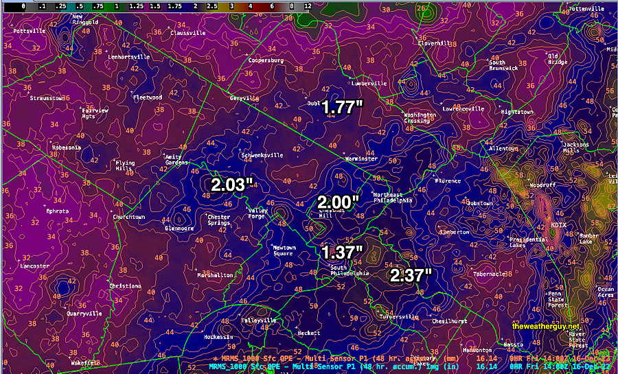
How much rain did we get?
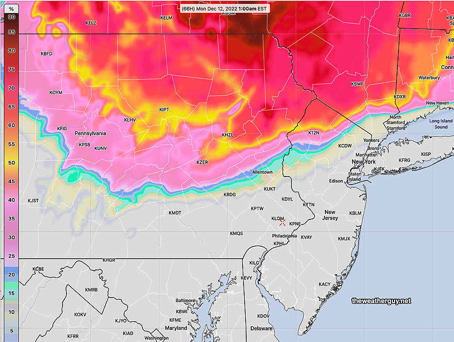
MRMS rainfall estimates through 9 AM Friday. (add another 0.10 inches through noontime) The numbered contours are in mm. 25.4 mm =1 inch. (Click on image for a larger view.)
Thursday Weather Update
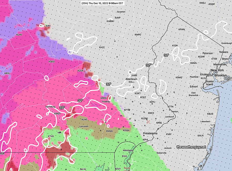
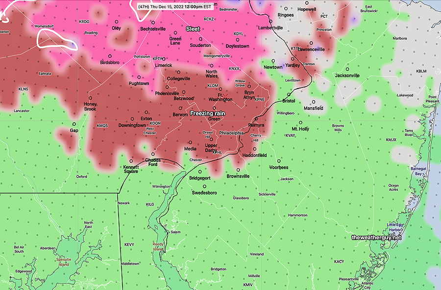
Update Thu 12/15 @ 1:08 PM — A changeover to all rain in the Philadelphia area. Heaviest rain between 6 PM and 11 PM. Total rainfall about 1.2″ to 1.7″
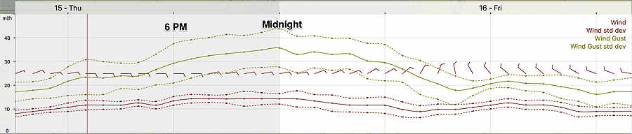
Highest wind gusts this evening towards midnight—
NBM wind meteogram for Blue Bell, PA . Highest wind gusts around midnight. (Click on image for a larger view.)
Following this storm, we’ll be going into a generally colder pattern for the week before Christmas. A snow storm is currently being forecast by the GFS, GEFS and ECMWF for Friday Dec 23rd. I’ll keep tabs on it.
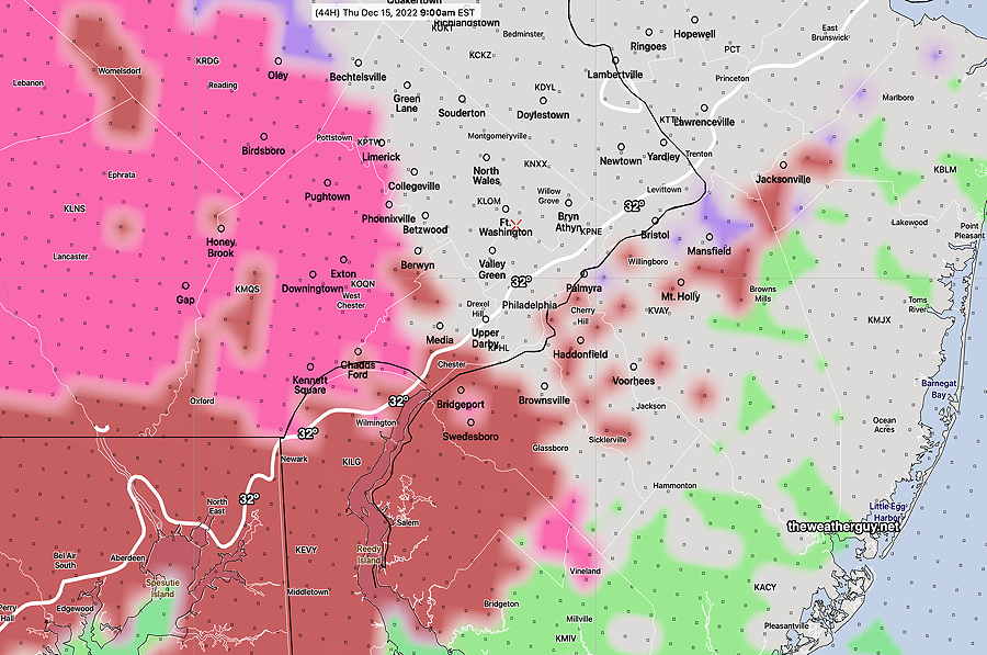
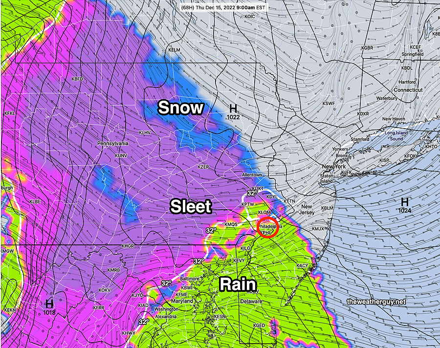
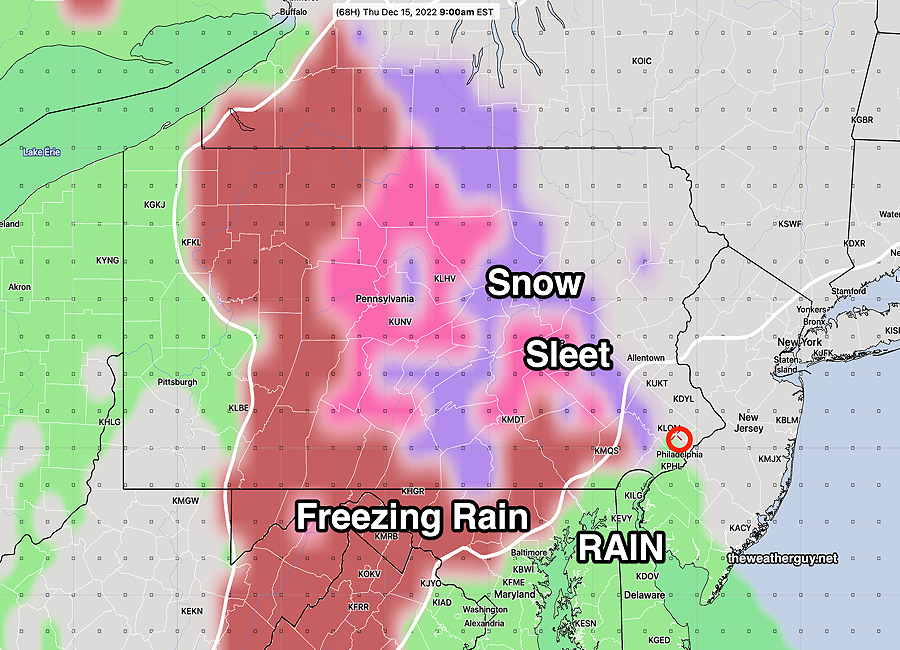
We’re getting more sleet than I had forecast; (“perhaps some sleet mixed with rain initially”) the delay of the precip as forecast by last night’s HRRR and NBM was wrong.
Temperatures in my neck of the woods are already above freezing (33º-34º) but a thin layer of colder air at about 2000-3000 feet is giving us the sleet. This layer may persist a bit longer as some dynamic cooling occurs, but a changeover to rain should occur about 9 AM.
With the sleet coming down, this morning’s HREF is showing it should be freezing rain rather than sleet, clearly not correct either.
Little Wintry Mix in Philadelphia & near Suburbs
Update Wed 12/14 @ 8:50 PM — A further review of the latest Canadian HRDPS and German ICON models as well as this afternoon’s ECMWF show a delayed onset of the precip here allowing temperatures to rise at critical levels of the atmosphere.
These models are in support of the preferred HRRR forecast—Little in the way of wintry mix (perhaps some sleet mixed with rain initially) except in areas of western Chester County and north into Lehigh County which may have more sleet/freezing rain before change to rain.
The models show very light precip moving in between 8 and 10 AM, with temps above freezing at critical vertical levels.
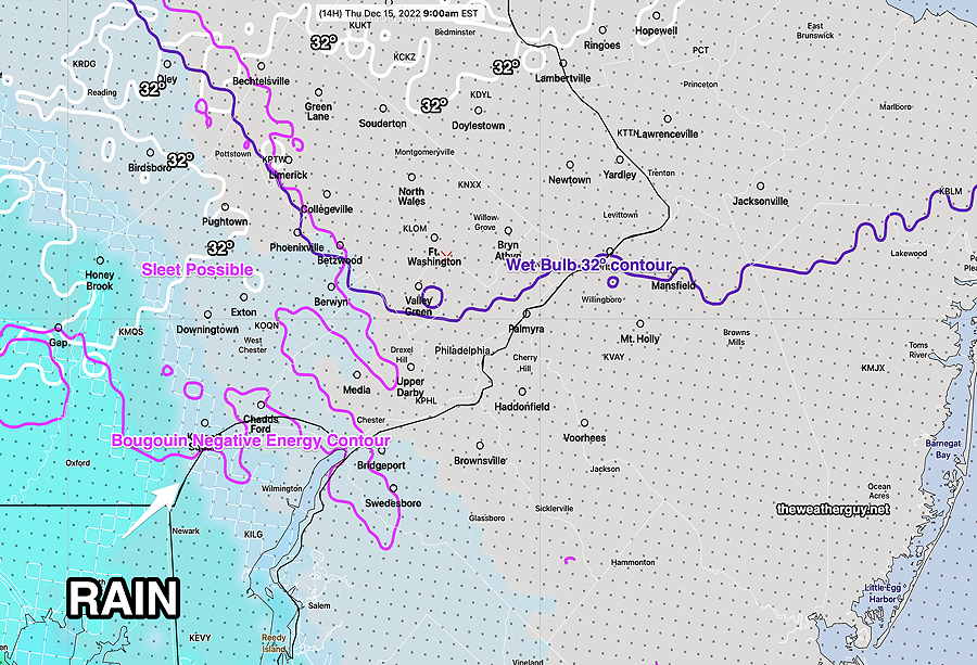
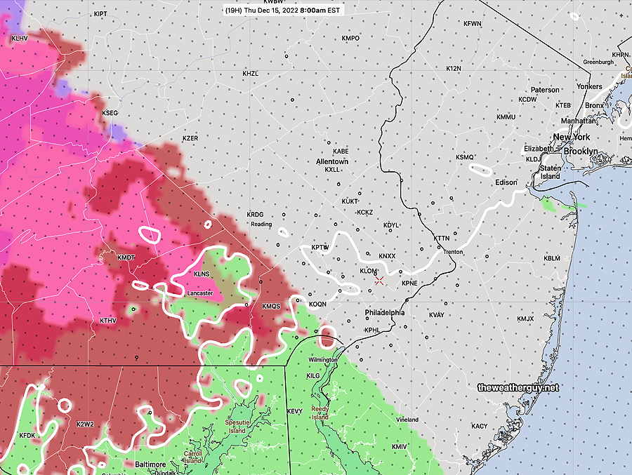
Tonight’s 00z NBM model captures this well at 9 AM; most of the precip is still south of the city with temps too warm for wintry precip here—
Tonight’s 00z NBM shows critical temperatures north of the precipitation at 9 AM. The precip has barely entered Philadelphia. Bourgouin negative energy contour is a measure of the likelihood of sleet. West and north of this contour are the areas which most likely to have sleet. It all changes rapidly to rain by late morning. Notice how far north the 32º line (white) is. (Click on image for a larger view.)
Update Wed 12/14 @ 5:52 PM — This afternoon’s models are consistent with my previous update; with the exception of the HRRR and Canadian HRDPS, they show an area of sleet and freezing rain moving in about 7-8 AM.
As mentioned, over past winters, the HREF and NAM-NEST and HIRESW comprising the HREF have over-forecast freezing rain/sleet.
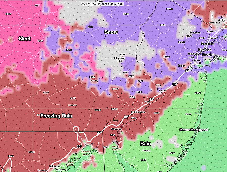
Here’s the current HREF Precipitation type (PTYPE) at 8 AM Thursday—
Today’s 18z HREF model PTYPE at 8 AM Thursday I believe the HREF is over-doing the freezing conditions . (Click on image for a larger view.)
Despite several models leaning towards the above, my preferred forecast model here is the HRRR shown below.
Here’s the HRRR forecast at 8 AM with the precipitation delayed to our south and the 32º line is already moving past Philadelphia—
18z HRRR forecast for 8 AM Thursday. White line is 32º surface temp dividing line. Precip is still south of our area. (Click on image for a larger view.)
As I forecast this morning, the HRRR has consistently been forecasting a slower onset of the precipitation, allowing the temperatures to rise before the onset. The HRRR is somewhat similar with the Canadian HRDPS, so I’m leaning towards a less wintry commute tomorrow morning
Here’s the HRRR forecast for 9 AM. Even less of a threat, with the precip still to our south—
18z HRRR forecast for 9 AM (Click on image for a larger view.)
Remember that the NWS and TV weather people need to concern themselves with safety concerns and liability, so they are always going to err on the side of a more safety-aware and cautious forecast. I’m just trying to give you my best insight.
I’ll do a quick update with tonight’s HRRR and the HRDPS about 9 PM tonight.
It looks like this forecast below from Wednesday morning might not have posted.
Update Wed 12/14 @ 7:45 AM — No significant change in the models, but review of last night’s 00z and 06z model runs suggests that the HREF model graphics posted last night may be over-estimating the freezing rain and timing of the precipitation.
While the HREF hasn’t changed, the HRRR has consistently been forecasting a slower onset of the precipitation, allowing the temperatures to rise before the onset. The HRRR is somewhat similar with the Canadian HRDPS, so I’m leaning towards a less wintry commute tomorrow morning. I’m basing this on recent winters where freezing rain was over-predicted by the current models.
My forecast is for light sleet and some freezing rain about 8-9 AM, changing to sleet and rain and finally all rain in the immediate PHL area by 11. The forecast assumes that the precip will be delayed to our southwest.
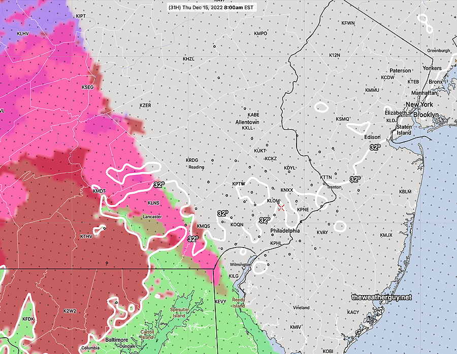
The HRRR 8 AM captures my current forecast—
HRRR forecast for 8 AM. Precip hasn’t reached PHL White line is 32º line (Click on image for a larger view.)
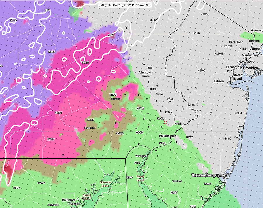
By 11 AM we have mostly rain —
HRRR forecast precipitation type by 11 AM. Notice the delayed/blocked preciip. (Click on image for a larger view.)
I’ll update later today.
Update Tue 12/13 @ 8:49 PM —
I’ve been reviewing today’s models and as usual, there are differences in their forecasts.
Here’s where they agree: Precipitation overspreads the area between 7 and 9 AM from the southwest. All change the precipitation to heavy rain, lingering into Friday morning. However the changeover to all rain may be gradual instead of rapid in northwestern areas. Winds gusting over 40 mph and rainfall amounts over 1 inch expected. Heaviest rain likely around midnight. Some rain lingering into Friday.
Here’s where there are differences: The temperature profiles of the models all vary quite a bit. On the warmer side is the GFS and ECMWF which has a changeover to all rain in the immediate area by 10 AM. The GFS has sleet and some snow in areas, along with freezing rain before a rapid changeover.
The higher resolution models, our NAM-NEST, the Canadian HRDPS, along with the HRRR (and throw in the German ICON) are somewhat colder with more areas of sleet lingering into late morning.
The HREF (ensemble model) probably captures things the best and is similar to the Canadian HRDPS (but colder than the GFS). Here’s its 9AM forecast —
Today’s 18z HREF model forecast for 9 AM Thursday shows light spotty precip northwest of the city, mostly sleet (pink) freezing rain (brick red). According to the HREF, the surface freezing line (32º) is just cutting through Philadelphia at 9 AM. (Click on image for a larger view.)
By noon, the HREF still shows considerable sleet and freezing rain. I think this is overdone and it will be mostly rain in the immediate area—
HREF forecast for noon Thursday is probably over-doing the frozen precip in the immediate Philadelphia area. I think it will be mostly rain here by noon if not earlier. (Click on image for a larger view.)
To further complicate things, the latest ECMWF and NBM became available while writing this update. It has an influx of cold air in the afternoon, suggesting there might be a mixed precip during the day in northwestern suburbs.
A very dynamic storm and I think we’ll have to wait until Wednesday night to nail it down.
Update Tue 12/13 @ 11:17 AM — Many of this morning’s models continue to show light precipitation moving in between 7 and 8 AM Thursday morning before temperatures rise above freezing.
NBM and the GFS have very light snow falling early (7 AM) with a changeover to sleet/freezing rain from 8 to 10 AM. The Canadian RGEM, SREF show no snow, but rather sleet and freezing rain between 8 and 10 AM.
The Thursday forecast period has now fallen within the range of some of the higher resolution models (60 hours) (NAM-NEST and HIREF-FV3). These models show the precip moving in later, after temperatures have risen. They have very little precipitation falling until the temperatures rise above 32º at 10 AM.
Tuesday’s 12z HIRESW-FV3 model showing precip hasn’t moved in at 9 AM. Temperatures above 32º in the immediate area. (Click on image for a larger view.)
So there’s still uncertainty about a possible bad commute to work or no real problem. Most of the high resolution models’ forecasts extend only to 48 hours and tonight’s model runs will begin to cover the time period in question. Stay tuned.
Update Mon 12/12 @ 8:21 PM — Additional review of the NBM and ICON models suggests a mix of snow/sleet/rain is possible even up until noon in some areas. (There’s more uncertainty than previously predicted, as the precip is now forecast to be moving in before the cold air leaves.)
Complicating this forecast is an 540 thickness line well north of our region, indicating temperatures higher up are too warm for snow, yet the current NBM shows a high probability of snow in some areas during the mid morning hours.
Eventually, it’s all expected to turn to rain. The question for our western and northwestern suburbs, will it be at 9 AM or 2 PM? Here’s the latest NBM conditional probability of snow —
NBM conditional probability of snow at 10 AM Thursday. (Conditional probability means if there is precipitation, will it be snow?) (Click on image for a larger view.)
Update Mon 12/12 @ 6:01 PM — Today’s models continue with a rain event for the storm expected to move in Thursday through part of Friday. However, the Canadian GEM (and now the GFS) continues to have the rain move in when the lower levels of the atmosphere will be cold—
Monday’s 18z Canadian RGEM (RDPS) model forecasts some sleet and even some freezing rain at the start (8-9AM just west and northwest of the city. A changeover to ALL RAIN is expected shortly afterwards. (Click on image for a larger view.)
The Canadian GEM model was updated last winter and it did very good with the few mixed precipitation events we had. So we’ll see if its forecast holds.
The latest GFS now has a similar forecast for 9 AM Thursday—
Monday’s 18z GFS forecast Precipitation Type for 9 AM Thursday morning. White line is 32º surface temp line. (Click on image for a larger view.)
Update Mon 12/12 9:08 AM — Considerable instability cloudiness today (Monday) with a chance of a widely scattered snow flurry in the early afternoon.
As for the storm expected Thursday through Friday, no significant change in the forecast. An all-rain event, however, the Canadian RGEM and the German ICON models have the rain moving in just before the cold air exits. There’s the possibility of some light freezing rain very early Thursday morning before a changeover to all rain.
Update Sun 12/11 9:16 PM — Considerable instability cloudiness tomorrow (Monday) with a chance of a widely scattered snow flurry in the early afternoon.
Update Sun 12/11 6:26 PM — No change with today’s models. All have it too warm for snow here Thursday through Friday. (The German ICON model has it possibly starting as light snow early Thursday morning, but quickly changing to all rain.) Heavy rain, high winds still expected.
The long range forecast for the period following this storm is for colder than seasonal averages for the following week. Jet stream pattern still suppots my 2023 Winter Season Snow Outlook.
Previously Posted Sun 12:09 PM —
Storm to affect us late Thursday through Friday
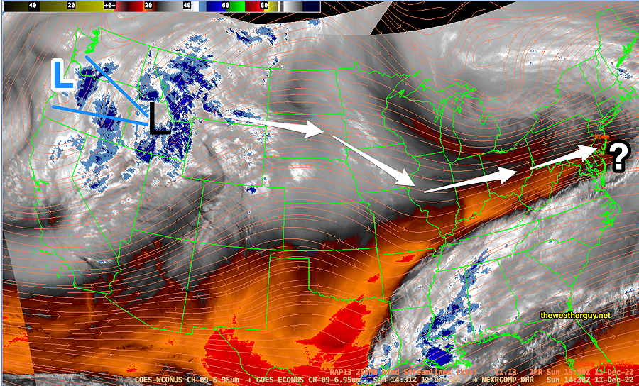
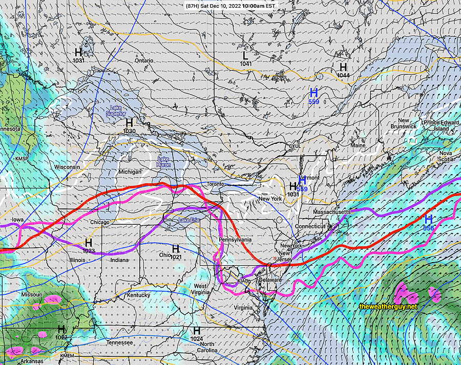
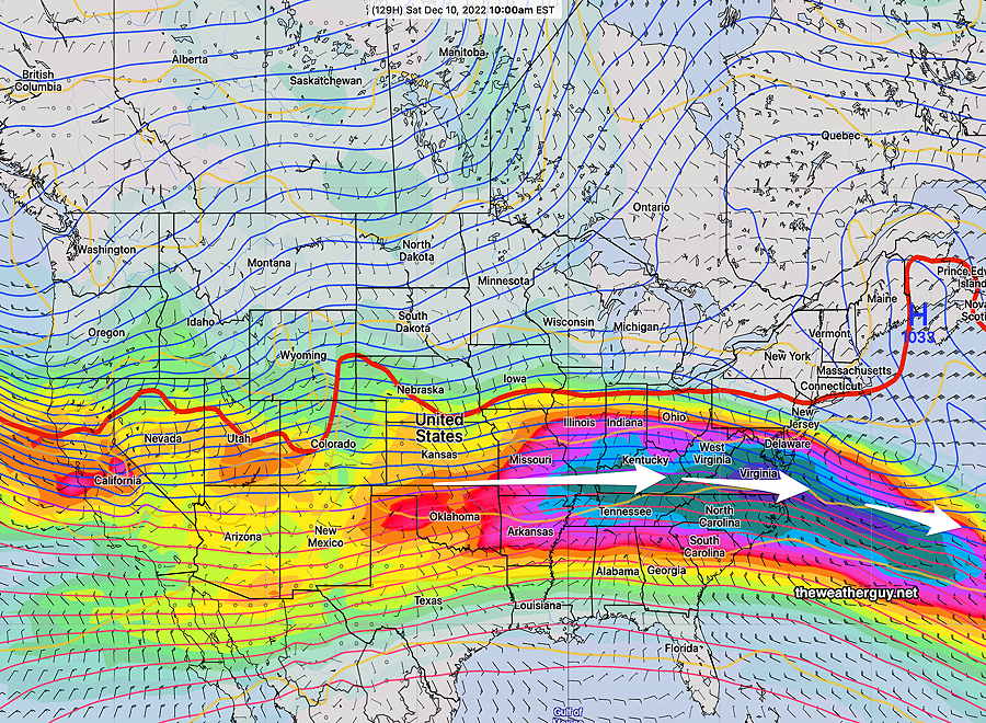
A strong upper air low and surface low are in Washington State today, Sunday.
Here’s current satellite water vapor image capturing the mid to upper atmosphere and showing upper air low L and surface level L—
Current Water Vapor image at about 10AM today, Sunday. Upper air low (BLUE L) with surface level low (BLACK L) Orange streamlines show RAP model jet stream flow (300 mb winds) superimposed on the current satellite image. Current general path of low (white arrows) (Click on image for a larger view.)
The low is expected to move over the Great Lakes and most models have it transferring its energy to a developing coastal low by late Thursday into Friday.
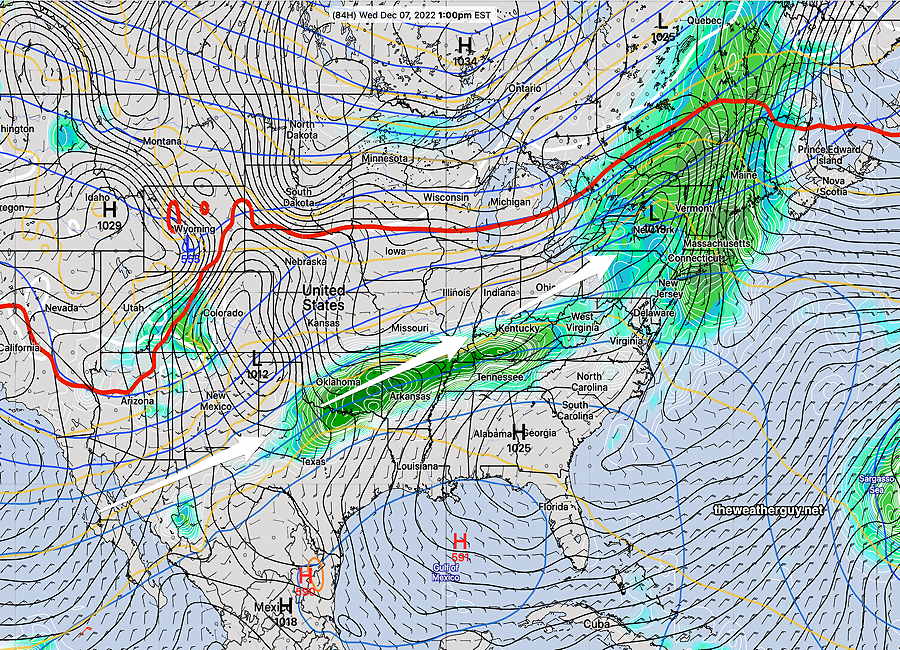
Here’s the very latest GFS model showing the coastal low—
Today’s 12z GFS model just available. Secondary low forms and affects us with heavy rain and wind early Friday morning. Two things to note: The red 540 thickness line is well north and west of us, indicating much of the atmosphere is too warm for snow here. Also note the the main low remains over Wisconsin, possibly affecting us further.
Two things to note: The red 540 thickness line is well north and west of us, indicating much of the atmosphere is too warm for snow here. Also note the the main low remains over Wisconsin, possibly affecting us later in the weekend.
A very complex and dynamic situation, but at least for the first round, we’ll have heavy rain and windy conditions in our area from this system late Thursday through Friday.
Indeed, the models show the possibility of another disturbance developing along the stalled boundary to our south and affecting us Sunday to Monday.
The forecast has already changed over the past few days. Other changes are likely. Stay tuned.
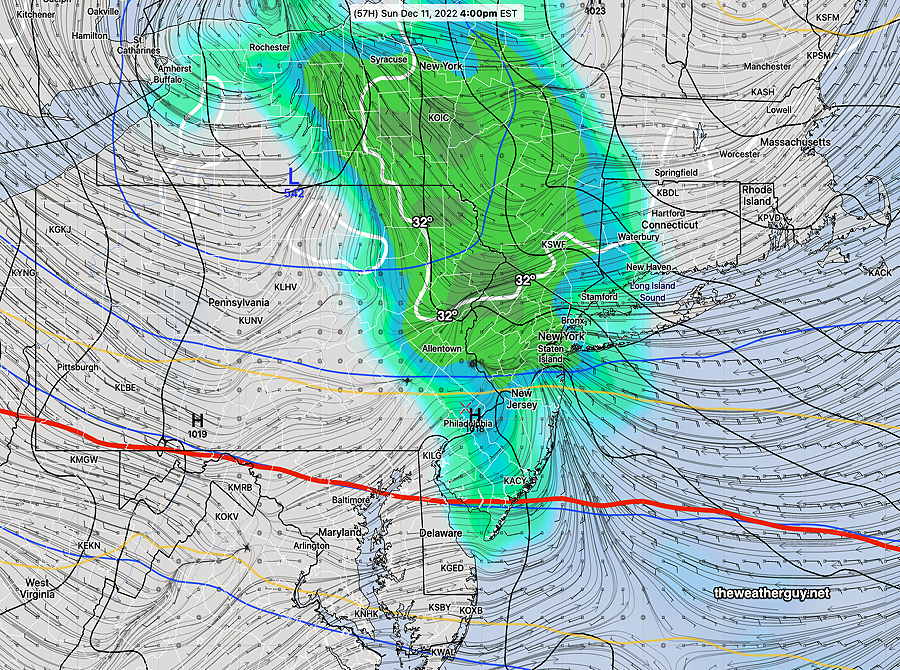
Update Sun 12/11 @ 9:53 — Forecast remains on track for today, Sunday. Heaviest rain here and at MetLife (Giants) Stadium will be from 2-6 PM. Rain totals here only about 0.20 inches or less; In East Rutherford NJ, it will be about double that amount. A bit windy.
Update Sat 12/10 9:04 PM — Tonight’s early models continue forecasting light showers moving in during the early morning hours, from west to east. Total rainfall about 0.25”
Areas north of Allentown may start as light snow changing to rain.
The period Thursday through Friday continues to look interesting. Stay tuned.
Update Sat 12/10 @ 10:46 AM — The latest models have some scattered light rain moving in as early as the morning hours Sunday, but the steadier light rain moves in between 1 PM and 4 PM Sunday. Total rainfall still light, only about 0.15 inches. (somewhat heavier rain/mix Allentown and north)
Models show the possibility of non-accumulating mixed precip in northern Montgomery and Bucks counties Sunday morning before a changeover to all light rain.
As for the potential storm Thursday into Friday, forecast differences in amount of cold air translate into significant differences in storm development and track. The ECMWF continues with a cold and deep coastal system, while the Canadian and our GFS have a much less developed upper trough. Stay tuned.
Previously Posted Fri 5:12 PM —
This weekend … and interesting weather next week
High pressure affect our weather on Saturday and will move off to the northeast on Sunday as low pressure moves north in Canada. A weak secondary low will form off in the Atlantic. Strong storm possible next week.
Saturday
Sunny weather for most of the day here, with some high cloudiness moving in between 2 and 4 PM. Light easterly winds.
High temperature 42.8º sd 1.9º NBM model Blue Bell, PA
Sunday
Low pressure in Canada will move north of us on Sunday as it transfers its energy to a weak low pressure system expected to develop in the western Atlantic.
Rain moves about noon and some rain is expected during much of the remainder of the day. The rainfall is expected to be light, less than 0.20 inches total.
Today’s 12z GFS shows precip in our area at 4 PM. The red 540 thickness line is south of us, indicating the upper atmosphere is cold enough for snow, BUT lower layers of the atmosphere are expected to be above freezing. No snow expected here at this time. (Click on image for a larger view.)
Temperatures in the upper atmosphere are expected to be fairly cold and there had been some forecasts showing cold air moving in that would change the light rain to a mix or light snow, especially northwest. The mixed precip and snow is no longer forecast in our immediate area.
High temperature Sunday 43.1º sd 1.6º NBM model, Blue Bell, PA
The NBM shows a high chance of some snow well to our north—
Today’s 12z NBM shows high probability of some snow (>.10 inches) well north of our area on Sunday. (Click on image for a larger view.)
Colder air moves in on Monday.
The ECMWF still shows some snow flurries possible here Monday afternoon.
The week ahead..
A deep storm is expected to move across the country Wednesday through Thursday. Some interesting weather looks to be in store for us late Wednesday into Thursday. Stay tuned.
12z GEFS forecast for next Thursday morning showing a possible changeover to snow in our area as low pressure develops along the coast. Too far in the future to be sure of anything. (Click on image for a larger view.)
Update Wed 12/07 @ 8:22 PM — Latest GFS shows snow showers or flurries in our area after midnight Sunday into predawn Monday. No real accumulation expected except north of Allentown where it will be below 32º. The GFS model has a somewhat unusual looking forecast map, so I must confess that I have low confidence with its current forecast—
Today’s 18z GFS shows snow (lavender shading) falling at 1 AM Monday morning. (Click on image for a larger view.)
Forecast Updates
Update Wed 12/07 @ 5:43 PM — see Sunday update highlighted below with possible snow showers Sunday evening.
Update Wed 12/07 @ 10:12 AM — Drier air will be gradually entering our area Wednesday afternoon, but today’s models show no sunshine, as the clouds are expected to hang tight. Clouds begin to break early this evening, but fog may form again towards midnight.
For Thursday, partly sunny, some clouds.
For Friday, things have finally clarified. Becoming partly to mostly sunny. No wintry mix expected in the evening as the ECMWF forecast has joined with the GFS; the cold high pressure will nose out the moisture to our south, keeping us dry even through early Saturday.
ECMWF forecast for early Saturday (10) shows high pressure nosing down into our area, suppressing any precipitation to our south. Notice the critical thickness lines are all to our south would have supported snow if any precip was falling. (Click on image for a larger view.)
For Saturday: mostly sunny. Increasing clouds in the late afternoon.
For Sunday: cloudy with rain most of the day. Update latest GFS and ECMWF show the possibility of light snow flurries or a coating Sunday night as low pressure develops off the coastline—
Today’s 18z GFS shows precipitation from low pressure developing off the coast with cold air aloft Sunday 6PM evening. Surface temperatures likely too warm for any accumulation, but precip may fall as snow. Unusual map appearance. Stay tuned. (Click on image for a larger view.)
Update Tue 12/06 @ 4:01 PM — The rain came in on schedule today, Tuesday. This weak but rainy system will exit Wednesday.
For Wednesday, we’ll be left with clouds, perhaps a few breaks of sun. High in the low 50s.
Commentary — Why do TV/radio weather people say “on YOUR Wednesday… “?
Is our Wednesday going to very different than their Wednesday?
For Thursday, partly sunny. High in the low 50s.
For Friday, another system approaches from the southwest. High pressure with cold air aloft nosing down from the northeast will either (1) suppress the moisture to the south, keeping us dry or (2) introduce enough cold air to allow a wintry, non-accumulating wintry mix to fall after midnight Friday-Saturday in areas especially west of the city.
Today’s GFS for 6 AM Saturday. The red, magenta and violet lines are ‘critical thickness’ lines which relate to the average temperature of certain layers (thicknesses) of the atmosphere. North of these lines, any precip will likely fall as snow. Notice that the GFS has enough cold air to suppress precipitation. The ECMWF, not shown, continues to show some precip as a wintry mix. (Click on image for a larger view.)
For Saturday, a northeast moist flow will send back a fair amount of cloudiness into our area.
Update Mon 12/05 8:53 PM — Regular visitors to this site know that over the past week, I’ve been watching for the possibility of a wintry mix to develop sometime over the Friday to Saturday timeframe. I nixed that possibility in last night’s outlook, based on the GFS and NAEFS. Today’s ECMWF has resurrected that possibility. The models have unusually low agreement in their forecasts for for later in the week. I’ll keep an eye on it.
Previously Posted Mon 11:04 AM —
Overview
A flat to slight ridge jet stream will influence our weather this week—
NAEFS Wednesday forecast for 250 mb winds (jet level). Included is the 540 thickness line. (Click on image for a larger view.)
The trend over the past few days is for the coldest air to remain further north of our area and for the flow to be more ridge-like with it just sinking southward by the weekend.
Moisture moving up from the southwest from the southern jet stream will bring a series of disturbances to our area with rain Tuesday into Wednesday and rain Friday into Saturday. With a flat to ridge-like jet flow, no major storms are forecast to develop, just these smaller disturbances.
NAEFS Surface forecast for Wednesday (Click on image for a larger view.)
By Saturday, the jet flow is flatter and further to our south, meaning colder air will move in——
NAEFS 250 mb forecast for Saturday. Includes 540 thickness line (red) (Click on image for a larger view.)
From the above map, we can see that some waves (note the wavy red 540 thickness line) are beginning to develop in Wyoming and Utah. This is the early stage of a large storm that will develop and affect us and much of the country next week.