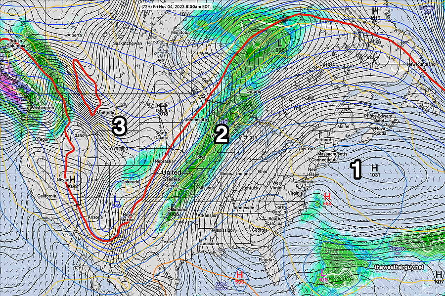
THIS WEEK’S WEATHER

Perfect Weather

Update Thu 11/03 @ 5:47 PM — Not much happening since my last update. Just perfect weather! Expected to continue! High pressure remains in control off the coast—

Today’s 12z NAEFS Forecast for Thursday. High pressure off the coast. A strong upper ridge over us (as shown by the red 540 thickness line) and a sharp trough in the West. That cold trough never makes it into our area. (Click on image for a larger view.)

The push of colder air in the West never makes it into our area. A front falls apart as it approaches later Sunday—

NAEFS forecast for Sunday at 7 PM. High pressure remains stationary in the Atlantic. The weak cold front falls apart in central PA. A tropical like storm develops near Florida, that needs to be watched. .

Mild Weather— Little Chance of Rain

Update Tue 11/01 @ 5:25 PM — A strong ridge of high pressure will maintain a southwesterly flow of mild air through the weekend and perhaps well into next week.

My caption on the NAEFS graphic below explains—

12z NAEFS forecast for Friday morning. A Bermuda-like High (1) off the coast will maintain a southwesterly flow of mild air into our region. A cold front (2) will lose its punch as the push of cold air (3) diminishes. The front shears off to our north and east on Sunday. For next week, a flat zonal flow will continue generally mild dry conditions .

Updated Mon 10/31 6:55 PM — So game 3 is officially postponed. It’s not clear to me why MLB waited so long. By this afternoon, there wasn’t a single model that wasn’t forecasting rain, if not by the start, by 9-10 PM.

So which model, if any, did the best with this forecast? Well, the ECMWF would have been the clear winner, but this morning’s ECMWF had the rain starting early in the afternoon. Clearly not correct and the model run last night had very little falling right along I-95 and the stadium.

The high resolution HREF, HRRR and NAM-NEST all kept the heavier rain off to the west of the city until later this evening. Clearly not correct.

Last night’s new GFS had the rain starting about 9-10 PM at the stadium. A little slow with the start time, but the general axis of the rain right now is just as predicted. Still, not a winner.

The German ICON model from this morning wasn’t bad. Some rain at about 7PM and increasing afterwards. Axis of rain isn’t what we have on radar.

Yesterday’s Canadian HRDPS, as was this morning’s, was surprisingly good. It had the rain starting about 7-8 PM and the rain axis is pretty much what we have right now. Not sure that it’s a winner, but close.

The bottom line — models rarely capture reality exactly, especially with precipitation placement and timing. This is something we get reminded about each winter with snow storms.


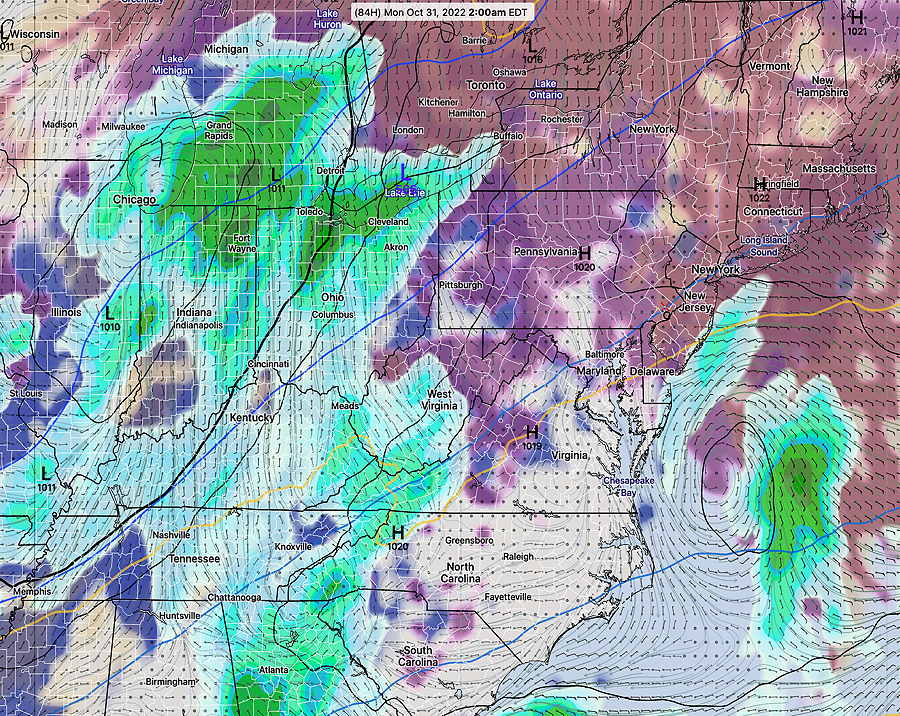
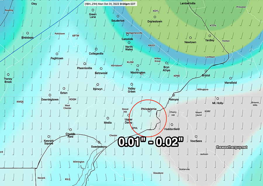
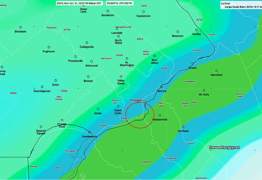
Update Mon 10/31 @ 4:58 PM — The lastest HRRR still keeps the heavier rain to the west of the stadium at 9 PM, but the rain moves in and increases in intensity after that time—

The earlier forecast that Trick-Or-Treaters would be OK before 7:30 – 8:00 PM probably is too optimistic.

Current Radar (5:10 PM)—

Radar with RAP model jet stream wind streamlines (red) at 5:10 PM (Click on image for a larger view.)

A radar image with motion captures that the rain is moving in rapidly—

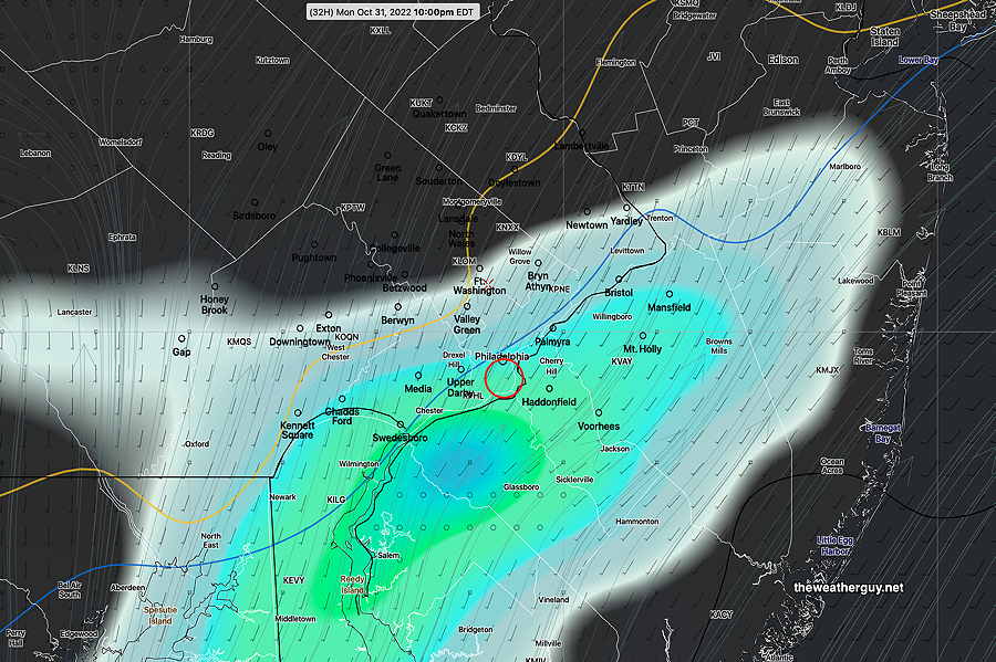
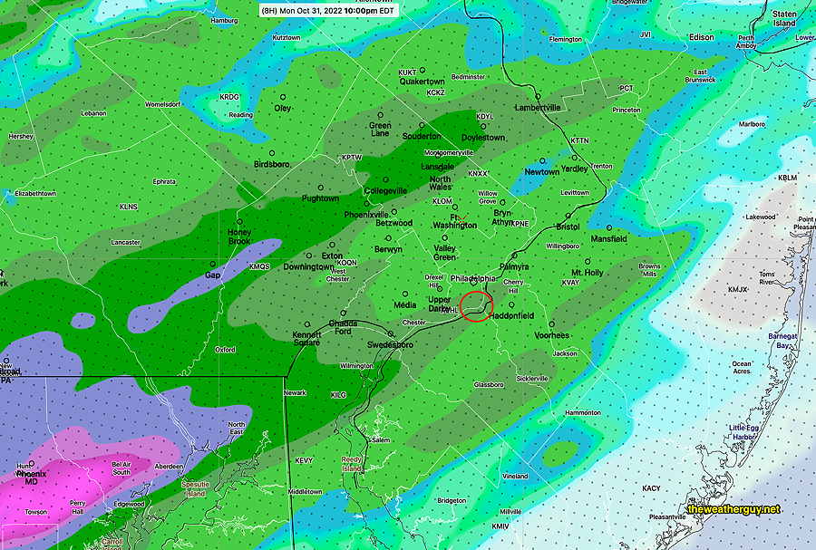
Latest HRRR model forecast total accumulated rain by 9 PM—

18z HRRR Total accumulated rain totals at 9 PM. the HRRR shows only light rain at Citizens Bank Park at 9 PM, but rain increases afterwards. If the Phllies play tonight, they will play in increasingly heavier rain. (Click on image for a larger view.)

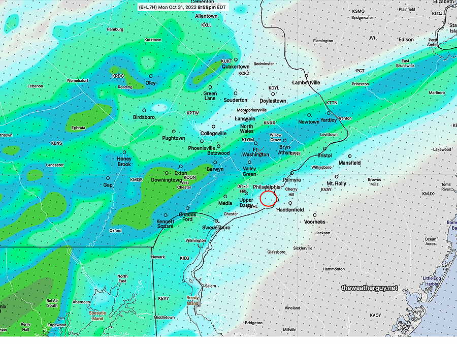
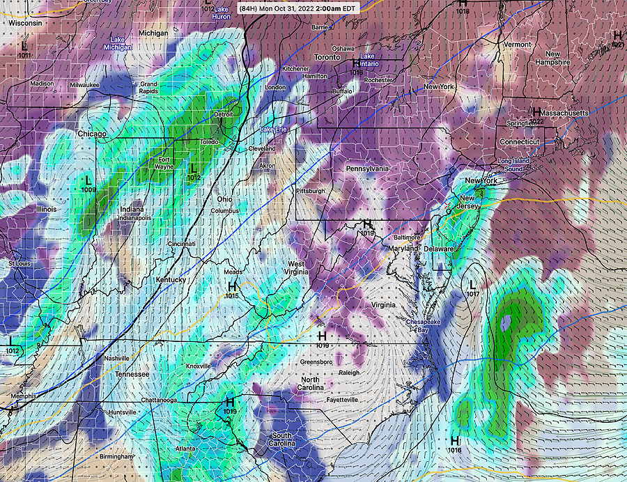
The NAM-NEST cranks out more rain than the HRRR. Here’s the Total Accumulated Rain forecast by 10 PM—

18z NAM-NEST forecast Total Accumulated Rain by 10 PM. Significant rainfall by then. (Click on image for a larger view.)

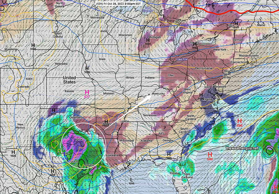
Previously Posted Mon 9:49 AM —

First order of business this week is the forecast for Trick-Or-Treaters and the Phillies World Series game this evening. I’ve been waiting for the latest ECMWF and NBM to become available before posting this.

Those of you following the weekend postings will know that the ECMWF has consistently forecast some light rain during the Phillies game this evening.

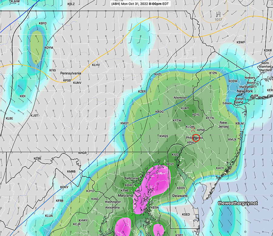
Here’s the latest ECMWF accumulated rain forecast for 9 PM—

06z ECMWF showing very light precip at 9 PM. By 11 PM, it increases only slightly to 0.02- 0.03″ (Click on image for a larger view.)

However, many of our high resolution models (HRRR, RAP, HIRESW, NAM-NEST) have all kept light rain in the western suburbs during the evening hours while keeping the immediate PHL area mostly dry until after 11 PM.

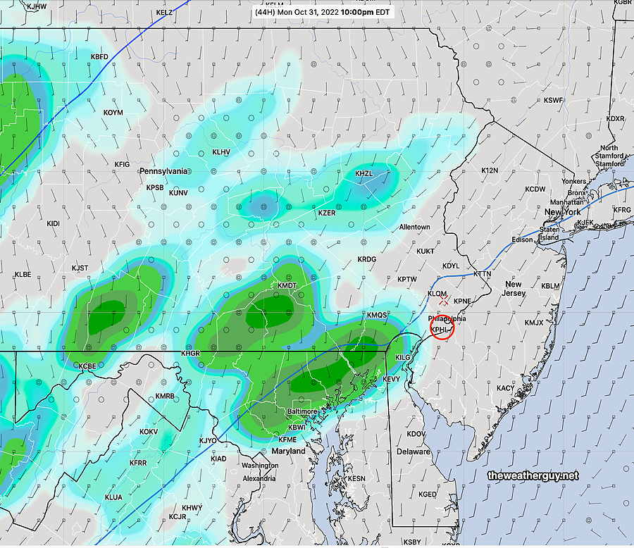
The new GFS-v 16.3 continues to have light rain move in between 9 and 10 PM. The high resolution Canadian model is similar to the GFS.

New GFS for 10 PM—

06z GFS (new version 16.3) showing considerable rain near stadium (0.11″) accumulated by 10 PM tonight. (Click on image for a larger view.)

The latest model blend (NBM) just became available and it captures the majority consensus —

12z NBM shows similar ot the ECMWF at 8 PM but increases accumulated rain to 0.07-0.10 inches of rain by 11 PM. Not great for baseball. (Click on image for a larger view.)

Based on the NBM, Trick-Or-Treaters should be fine in most of the area before 7:30 to 8 PM.

For the World Series Game 3, some light rain expected by 9 PM which will increase by 11 PM which may require some decision-making by MLB.


WEEKEND WEATHER OUTLOOK

Update Sun 10/30 @ 8:19 PM — I guess I need to say that my previous forecast update below is tilted perhaps towards too much optimism. Here’s the latest Canadian High Resolution model—

Today’s 18z HRDPS forecast for 9 PM Monday night. (accumulated rain) (Click on image for a larger view.)

Update Sun 10/30 @ 8:04 PM — This afternoon’s models have clustered towards the following forecast for Monday evening— with the exception of the ECMWF, rain won’t arrive in Philadelphia until after 10 PM. Some suburbs to our west may see some very light showers as early as 7-8 PM. If the GFS is correct, some light rain moves into Philadelphia just as the Phillies are wrapping up (well, maybe the 7th inning) for a game 3 win. Somewhat heavier rain moves in later Monday night into Tuesday morning.

Comparing GFS 16.2 and new GFS 16.3 (today’s 18z model run)

GFS version 16.2—

GFS 16.2 forecast for 10 PM accumulated rain. (Click on image for a larger view.)

New GFS v 16.3—

GFS (newest version) 16.3 forecast 10 PM Monday night. (accumulated rain and clouds (black) ) (Click on image for a larger view.)

Update Sun 10/30 @ 9:27 AM — Another beautiful day expected for today, Sunday. But there’s a lingering question about the chances for rain Monday evening for the Trick-or-Treaters and the Phillies World Series Game.

The ECMWF has consistently shown rain between 7 and 11 PM for Monday evening. This forecast is supported, in part, by the Canadian High Resolution model and the German ICON model.

The ECMWF 3 hour accumulated rain forecast for Monday evening—

Today’s 00z ECMWF forecast for Monday evening at 8 PM. (3 hour accumulated rain) (Click on image for a larger view.)

The US models have consistently shown rain moving in later, about 10-11 PM.

Here’s the latest GFS (new version 16.3)—

Today’s 06z GFS forecast for 10 PM Monday. (3 hour accumulated rain) (Click on image for a larger view.)

Unfortunately, I am now leaning towards some light rain during the Phillies game, possibly about 9-10PM. Rainfall may be as little as 0.03″ but the ECMWF shows 0.20″- 0.40″.


Updated Fri 10/28 10:27 PM — Saturday- Sunny. High 60°
Sunday mostly sunny. Some clouds may move in during Sunday afternoon in our southern and western suburbs. High 62°.

Most models have Halloween mostly dry. The exception is the ECMWF which has significant showers during the evening.

Previously Posted Fri 9:51 AM —

High pressure will slowly move off to the northeast while a storm shears off to our wesst late Sunday into Monday. (The storm brewing near Texas could be the Phillies?!)

Mostly sunny skies expected for Saturday and some clouds and sun are forecast for Sunday.

Current Water Vapor (jet stream level) —

WV Satellite image captures upper atmosphere. (Water vapor imagery is NOT clouds. It shows temperature, moisture height and motion.) Low pressure is expected to shear off to our northwest late in the weekend. (Click on image for a larger view.)

Here’s the new GFS (v. 16.3) model forecast for Friday afternoon at 2 PM. It shows some mid-level cloudiness moving in from the west—

GFS v 16.3 forecast for today, Friday at 2 PM. (Click on image for a larger view.)

Let’s see how the new GFS does with the today’s cloud forecast.

Halloween evening is looking much better than it had previously.