Updated Fri 8:12 AM — An early preliminary update.
Not unexpectedly, the models are backing off on the rain for the weekend. (Dry spells are hard to break.)
For today, Friday, there’s a chance of very widely scattered popup showers/thunderstorms late afternoon, mainly from Philadelphia and eastward.
Much of Saturday looks to be just unsettled with our immediate area dry until showers move in from the west later in the day or evening. Now, much of the activity goest to our north and our south.
After some lingering showers on Sunday morning, it looks like things dry out for much of Sunday.
I’ll do a complete Weekend Weather Forecast later today.
Updated Thu 6:06 PM — We may get some much needed rain. Unfortunately, it may come this weekend. The GFS, ECMWF and the NAM all have low pressure developing in the area of the upper trough depicted in my original post graphic below, as the strong ridge in the middle of the country temporarily retreats.
The timing of the rain varies with the models. The NAM has showers moving in early Saturday. The GFS during the evening hours. The ECMWF late Saturday night and early morning Sunday. The ECMWF is notable for some very heavy rain Saturday night.
Despite these model forecasts, these dry spells are difficult to break down. Low soil moisture reduces the usual feedback loop for rain production.
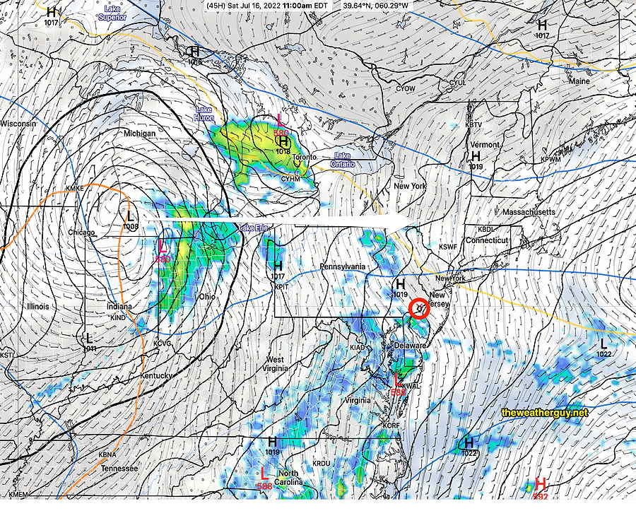
Current NAM forecast for 11 AM shows showers ready to move in.
Today’s 18z NAM forecast shows showers breaking out as early as 11 AM. (Much earlier than the other models currently.) (Click on image for a larger view.)
Tomorrow’s model runs will hopefully better define the timing.
BTW, all models keep unsettled conditions for Sunday, with some scattered showers. Stay tuned.
Previously Posted Wed 10:30 AM —
A persistent upper level high in the middle of the country that has been resulting in recording breaking high temperatures for central parts of the country shows signs of a slight retrograde to the west allowing the Bermuda high in the Atlantic to move slightly westward.
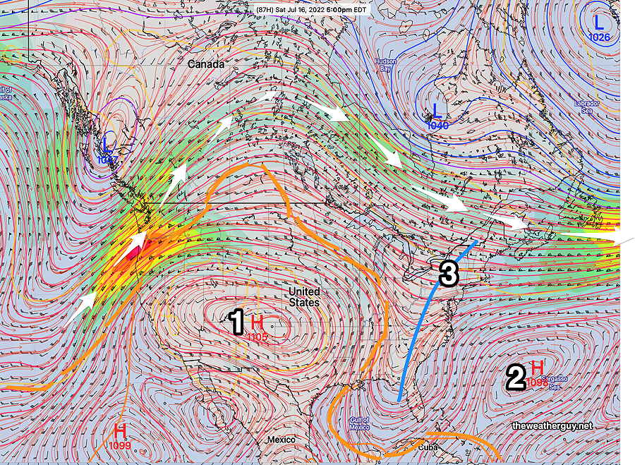
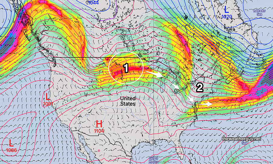
An upper trough will develop in the middle and affect our weekend. The caption for the graphic below explains the salient issues.
GEFS jet-stream level forecast for Saturday. The persistent upper level high (1) shows signs of moving slightly westward. The extent of the air mass associated with this high – the orangethickness contour- which has been nosing upward into our area (and reducing our rain chances) will retreat westward and dip down into the Gulf of Mexico. The usual summertime Bermuda high (2) will assume a more typical summer-time position, allowing much more moisture to stream up along the upper trough (3) giving us an increased chance of rain by Sunday. The jet stream flow is well north into Canada (white arrows.
The slight pattern change, described in the caption above, will result in increasing moisture and and increasing chance of showers by Sunday.
Until then, typical summertime weather for us.
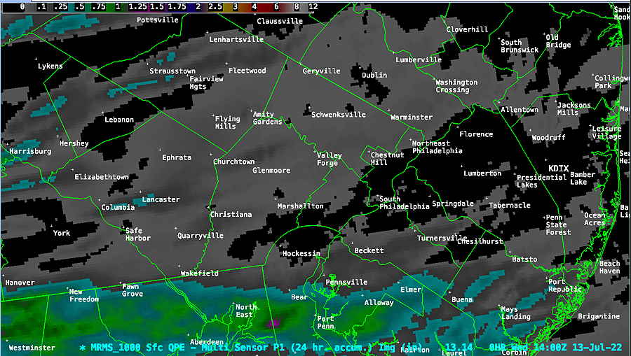
I was listening to the radio this morning…they were talking about the ‘cooler weather behind all those heavy thunderstorms we had Tuesday’.
There were virtually no heavy storms in our immediate area.
What the heck are they talking about?? Here’s MRMS precipitation summary for the past 24 hours:
Average rainfall over our area yesterday was less than on the order of 0.04-0.06 inches of rain. What heavy thunderstorms??
Update Tue @ 5:32 PM —Forecast Review— We have yet another situation this summer where some of the higher resolution models significantly over-predicted the chance and severity of thunderstorms.
Last night’s NAM-NEST was one of the first to show the storms falling apart as they approach Philadelphia. Last night’s ICON and ECMWF were in similar agreement. With the advanced HRRR and HIRESW models showing significant storms, I can understand the inclination to over-predict as a matter of public safety; Better to be safe than sorry.
That said, the RAP, ICON, NAM-NEST and ECMWF have been most reliable in recent failed storm forecasts. I first expressed my concern about a developing dry spell this past Sunday. Check out my earlier comment and graphic about potential drought or dry spell.
Update Tue @ 1:07 PM — The latest ECMWF, ICON, Canadian R-GEM and our RAP model have been consistent forecasting strong to severe storms to be mostly northwest of the city and they will significantly reduce in intensity as they approach Philadelphia and move eastward.
So there are large differences in the high resolution and global models. Considering the dry period we’ve been in, I’m leaning again towards the storms losing much of their punch (and moisture/rain) as they move into the immediate PHL area and into NJ.
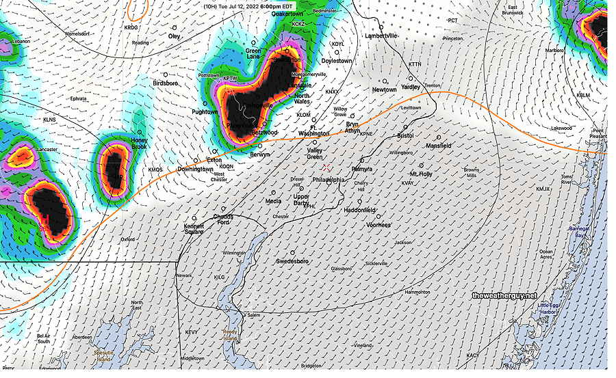
Here’s the latest Canadian R-GEM with it’s accumulated rain forecast—
12zCanadian Regional GEM model showing the areas of heaviest rain and storms north and west of the city. This is a very different forecast than NOAA’s high resolution models. (Click on image for a larger view.)
Update Tue @ 10:34 AM — The short range high resolution 12z models are becoming available. All models show the storms moving from northwest to southeast beginning 4-5 PM in far northwestern suburbs and 6-11 PM from Philadelphia and eastward. The models show:
Strongest storms, possibly severe, northwest of the city.
Storms may diminish in intensity after passing through Philadelphia into New Jersey.
Storms coming possibly in two waves, 5-8 PM and around 10-11 PM
12z HRRR : Area and timing of strongest/severe storms about 6 PM tonight northwest of the city. (Click on image for a larger view.)12z HIRESW showing areas of heaviest rain and strongest storms. (Click on image for a larger view.)
Updated Mon 11:02 PM —Tonight’s NAM-NEST has the storms falling apart before they make it into Philadelphia. Despite the NWS indicating strong storms tomorrow evening, I think Philadelphia and east will get only the weak remnants of any storms that affect our northwest suburbs. However, tonight’s HIRES-W has a strong line of storms moving through between 5 and 7 PM. Much uncertainty.
Updated Mon 9:57 PM —Tonight’s models show the storms, some strong, making it into Philadelphia tomorrow between 5 and 7 PM, but diminishing significantly as they enter into NJ.
Updated Mon 7:50 PM —Today’s models continue to show a cold front will drop down through our area late tomorrow afternoon.
Water Vapor showing low pressure (white circle) and cold front Monday night. (Click on image for a larger view.)
Today’s models are not in agreement with the likelihood of thunderstorms in all areas Tuesday afternoon with the cold front passage.
As discussed with last night’s graphic, the models continue to show a barrier of warm, stable air that any storms will have to overcome.
Most models have scattered, strong stormsin the northwest suburbs between 4 and 8 PM.
But, several models show these storms pushing against this warm mound of air over Philadelphia and losing their punch as they try to move eastward. So areas, especially from Philadelphia and eastward may not have much more than 0.2-0.3 inches of rain. (We need the rain.)
The 18z HRRR and HIREF models from this afternoon are the most aggressive with the rain here. But the 21z RAP, the Canadian GEM, Canadian HRDPS, the ECMWF, and the ICON don’t show much rain for the immediate PHL area and areas eastward.
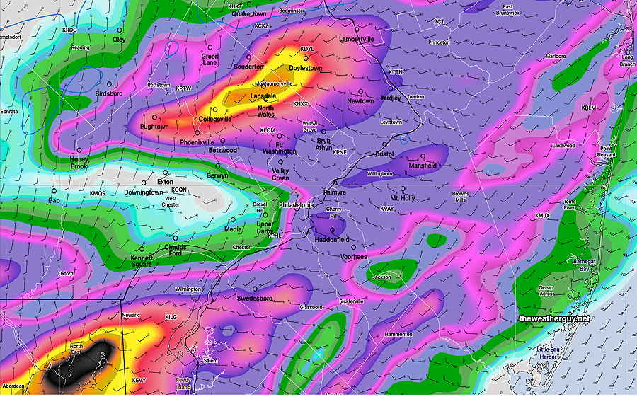
Today’s 21z RAP model shows high CIN (brown shading) (Convective Inhibition) at 2 PM. As the name implies, CIN works against convective development (thunderstorms) (Click on image for a larger view.)
As has been the case many times this summer, these storms blossom again near Baltimore MD and southern Delaware.
Our relatively dry spell of weather may not broken with only a few tenths of an inch of rain tomorrow.
I’ll update Tuesday morning after 10:15 AM with the new models.
Previously Posted Sun 9:20 PM —
Perhaps you’ve noticed that we haven’t been getting all that much rain this season (especially compared to the last two year’s endless barrage of severe thunderstorms.)
I’ve been noticing that storms have been falling apart as they approached. (Areas to our south in Delaware and Maryland have been getting much more rain.)
Frankly, the way things have been unfolding reminds me of the drought that developed here in 2000-2001. I haven’t heard anybody use the “d” word and I’m probably jumping the gun on this, but things are getting awfully dry in some areas.
Speaking of lack of rain, this week may continue this trend.
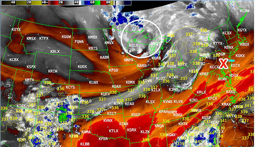
A disturbance is moving through the upper Midwest tonight, will intensify as it’s joined by other energy in Canada—
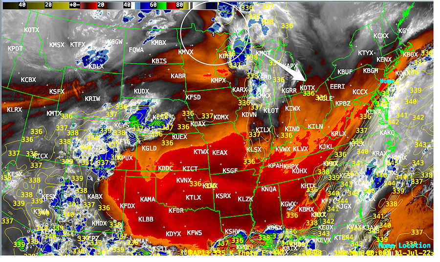
WV image Sunday evening showing disturbance (white circle) expected to intensify and move through here Tuesday night. (Click on image for a larger view.)
The GEFS model shows that disturbance—
GEFS (mode) showing upper air disturbance on Sunday night (1) will follow the summer-time weak jet flow and will reinforce the trough (2) currently over us. A front will move through with this disturbance Tuesday late afternoon and night. (Click on image for a larger view.)
We’ll see increasing heat and humidity Monday and especially Tuesday. Dew points may reach 70+º Tuesday with temperatures over 90º
Despite the setup for significant thunderstorms late Tuesday afternoon and night, somecurrent models suggest that the heaviest rain will develop south of our area. (The GFS shows over an inch of rain for the city (but very little just north and west) and it had over-predicted the rain Friday night into Saturday throughout our area.)
I’m always looking for clues to what is influencing the weather, in this case, the lack or rain. This is the GFS forecast for 6 PM Tuesday. The orange contour line is a “1000-500mb thickness contour”. I like to think of it as a wedge of stable air that is blocking the storms from developing. This thickness wedge has been present over our area for awhile. I’m not aware if this holds any proven scientific explanation, but I’m always looking for clues to weather trends and this one makes sense to me. The GFS does forecast only 0.2 inches of rain (Click on image for a larger view.)
Will the dry spell continue? Updates during the week.