THIS WEEK’S WEATHER

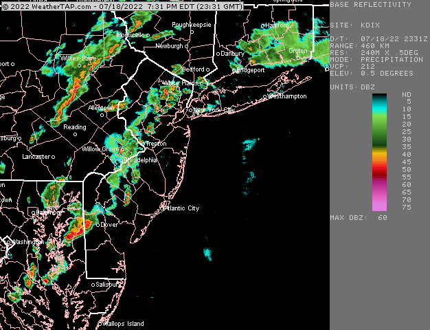
Update Mon @ 7:51 PM — Weak thunderstorms that began in Chester county mid afternoon have moved up and diminished significantly in strength—

Current radar Monday at 7:49 PM. Line of weak storms moved through and are diminishing in intensity, as forecast by several models. Some additional activity may affect some areas before the front moves through tonight. (Areas moving up from Delaware into NJ have some advantage to staying together, passing over the Delaware Bay.) This sort of system will not make much of a dent in our dry weather. (Click on image for a larger view.)

Updated Mon 1:30 PM — A quick mobile update. There are 3 versions of the HIRESW model. The HIRESW-FV3 only shows one line of storms about 5-6 PM, closer to the NAM-NEST forecast. The earlier update based on the HIRESW-ARW is clearly not correct.

Updated Mon 11:14 AM — A quick mobile update. The HIREW model just available shows two lines of storms one moving through early afternoon and another about 7 PM

Update Mon @ 9:25 AM — This morning’s models aren’t available at the time of this update. There’s still a range of forecasts from the models. Some show storms developing in a more random fashion. Some show a distinct line moving through this evening.

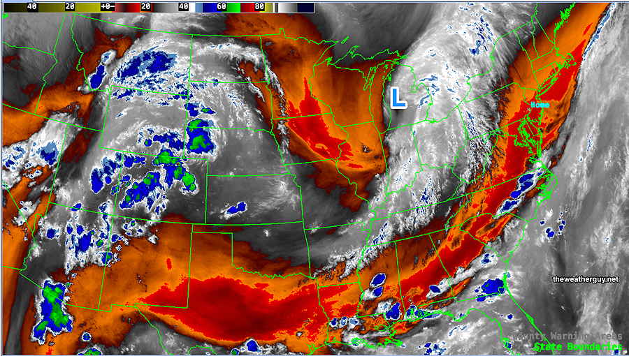
The best forecast, based on current radar, water vapor and the NBM model suggests storms develop in mid afternoon western areas of Chester and Montgomery counties and gradually move eastward, arriving in the immediate PHL area between 6 and 9 PM.

With vertical wind shear values relatively low, I don’t see severe storms in our immediate area, despite very high CAPE values.

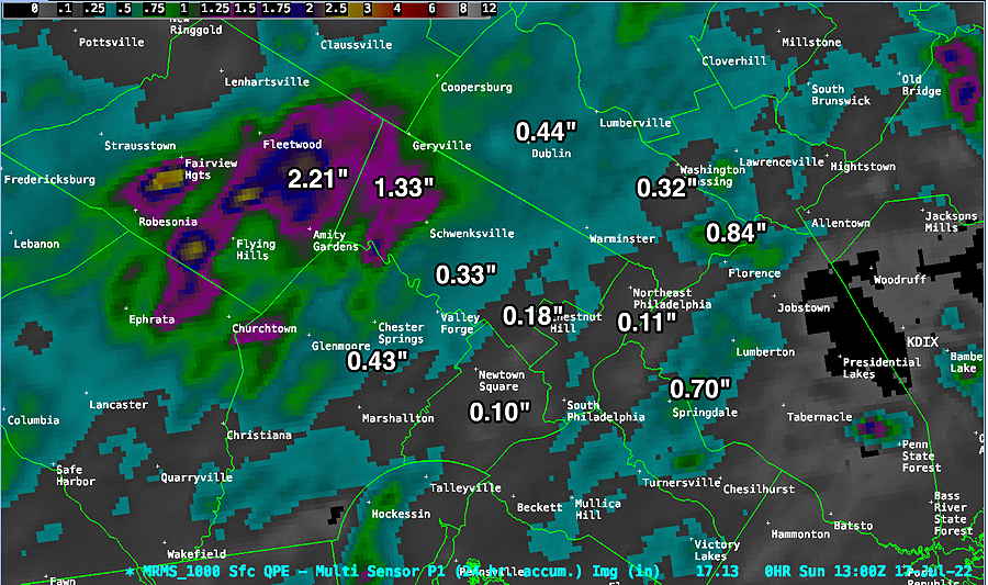
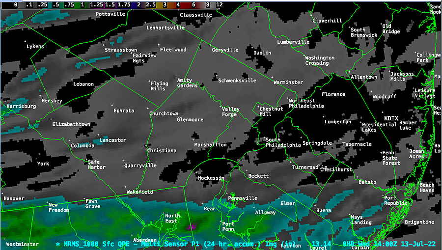
There is evidence that the storms may diminish in intensity just as they arrive in Philadelphia. Areas from Philadelphia and eastward may receive much lower amounts of needed rain.

I’ll be posting more about our dry current spell and some theories about it later this evening.


Previously Posted Sun 11:13 PM —

A complicated forecast for tonight into Monday as the models have a wide range of forecasts.  Some show a chance of showers tonight into early morning Monday, while others have very little in the way of precipitation tonight.

Several high resolution models show scattered storms during the day, as early as 2 PM, with additional storms late afternoon and evening.  The NAM has another line of storms around 11 PM.

So, the bottom line is an unsettled day with several chances of storms with locally heavy rain any time after 2 PM.

Adding to the uncertainty is some model suggestion that storms may fall apart as they move east into NJ.


WEEKEND WEATHER FORECAST

Unsettled but very little rain?

Updated Sun 4:38 PM — We’ve had no showers this afternoon (as forecast by the NAM-NEST, not the ECMWF). There may still may be some scattered activity late tonight.  The main area of showers will move off to our north tonight.

The cold front comes through early evening Monday.  The NAM-NEST shows a line of storms, but they may diminish in intensity as they move through our area. Updates tomorrow.


Update Sun @ 10:14 AM

Forecast Review— We had some scattered storms after midnight, not forecast by last night’s US models. Still not much rain in the immediate PHL area—

MRMS rainfall totals. The immediate PHL area received anywhere from 0.10″ to 0.44″, with a few localized exceptions. (Click on image for a larger view.)

Sunday will be partly sunny/partly cloudy very warm and humid. High 86º ± 1.1º Dew points near 70º will make it feel much warmer. (~90º)

Sunday satellite water vapor image shows current conditions: warm front in western PA that will move north. Some models have most of the showers with this warm front moving north of our area tonight. Some models have some storms 3-5 PM this afternoon ahead of the front.

A warm front will move through around midnight with showers and thunderstorms. Most models have the bulk of the rain moving to our north. The ECMWF shows some storms developing around the Delaware Valley abut 3-5 PM or so, ahead of the warm front passage this evening.

The ECMWF 3 previous hour rainfall forecast for 5 PM —

ECMWF forecast 3 hour rainfall at 5 PM today. Notice how the rainfall seems to bypass Philadelphia! (Click on image for a larger view.)

It should be noted that the NAM-NEST shows no showers here this afternoon. I’m including the ECMWF graphic because the ECMWF more correctly forecast the showers last night.

Monday afternoon shows the greatest promise of showers and thunderstorms here.


Updated Sat 11:11 PM —The rain most areas had today was minimal. For Sunday, there will be even less chance of rain.

Temperatures approaching 88° will feel hotter with dew points near 70°. There’s a chance of highly isolated showers around 6 PM. Any rain Sunday night is forecast to move north of us.  We’ll have to wait for Monday late afternoon for any chance of significant rain.
Even Monday may not offer relief from the dry conditions.

Show More

Sunday

Previously Posted Fri 8:21 PM —

Some low clouds, maybe fog, in the morning. Perhaps a few sprinkles early. Most of the day will be a mix of sun and clouds. Little or no rain until evening.

GFS forecast for Sunday at 2 PM. Not much rain. (Click on image for a larger view.)

In fact, the latest NAM-NEST shows heavy storms in far western suburbs about 11 PM, falling apart as they try to move east towards us.

High temperature 86.5º ± 2.6º NBM model Blue Bell, PA


THIS WEEK’S WEATHER

Less Unsettled Weekend

Updated Fri 8:12 AM — An early preliminary update.

Not unexpectedly, the models are backing off on the rain for the weekend. (Dry spells are hard to break.)

For today, Friday, there’s a chance of very widely scattered popup showers/thunderstorms late afternoon, mainly from Philadelphia and eastward.

Much of Saturday looks to be just unsettled with our immediate area dry until showers move in from the west later in the day or evening. Now, much of the activity goest to our north and our south.

After some lingering showers on Sunday morning, it looks like things dry out for much of Sunday.

I’ll do a complete Weekend Weather Forecast later today.


Updated Thu 6:06 PM — We may get some much needed rain. Unfortunately, it may come this weekend. The GFS, ECMWF and the NAM all have low pressure developing in the area of the upper trough depicted in my original post graphic below, as the strong ridge in the middle of the country temporarily retreats.

The timing of the rain varies with the models. The NAM has showers moving in early Saturday. The GFS during the evening hours. The ECMWF late Saturday night and early morning Sunday. The ECMWF is notable for some very heavy rain Saturday night.

Despite these model forecasts, these dry spells are difficult to break down. Low soil moisture reduces the usual feedback loop for rain production.

Current NAM forecast for 11 AM shows showers ready to move in.

Today’s 18z NAM forecast shows showers breaking out as early as 11 AM. (Much earlier than the other models currently.) (Click on image for a larger view.)

Tomorrow’s model runs will hopefully better define the timing.

BTW, all models keep unsettled conditions for Sunday, with some scattered showers. Stay tuned.


Previously Posted Wed 10:30 AM —

A persistent upper level high in the middle of the country that has been resulting in recording breaking high temperatures for central parts of the country shows signs of a slight retrograde to the west allowing the Bermuda high in the Atlantic to move slightly westward.

An upper trough will develop in the middle and affect our weekend. The caption for the graphic below explains the salient issues.

GEFS jet-stream level forecast for Saturday. The persistent upper level high (1) shows signs of moving slightly westward. The extent of the air mass associated with this high – the orange thickness contour- which has been nosing upward into our area (and reducing our rain chances) will retreat westward and dip down into the Gulf of Mexico. The usual summertime Bermuda high (2) will assume a more typical summer-time position, allowing much more moisture to stream up along the upper trough (3) giving us an increased chance of rain by Sunday. The jet stream flow is well north into Canada (white arrows.

The slight pattern change, described in the caption above, will result in increasing moisture and and increasing chance of showers by Sunday.

Until then, typical summertime weather for us.

I was listening to the radio this morning…they were talking about the ‘cooler weather behind all those heavy thunderstorms we had Tuesday’.

There were virtually no heavy storms in our immediate area.

What the heck are they talking about?? Here’s MRMS precipitation summary for the past 24 hours:

Average rainfall over our area yesterday was less than on the order of 0.04-0.06 inches of rain. What heavy thunderstorms??