Updated Sat 7:48 PM — Sunday will be sunny. Still very windy. Wind gusts 30-40 mph. High temp 73.4º ± 1.5º NBM model Blue Bell. (Average seasonal high this time of year is 83-84°)
Update Sat @ 10:25 AM —
Forecast Review— Despite the lack of most models’ support, instability cloudiness did develop during Saturday morning. Why the models don’t seem to forecast this very well is a mystery to me, but I’ve seen it happen many times in similar setups.
Increasing sunny breaks and sunshine should begin during the afternoon; I’m basing this on the ICON and ECMWF models which did show this cloudiness.
Updated Fri 11:06 PM — Tonight’s models have backed away from the Saturday morning cloudiness.
Update Fri @ 5:59 PM — Forecast Updated in below
High pressure builds in behind a cold front Friday. We’ll be under the influence of high pressure at the surface and low pressure aloft—
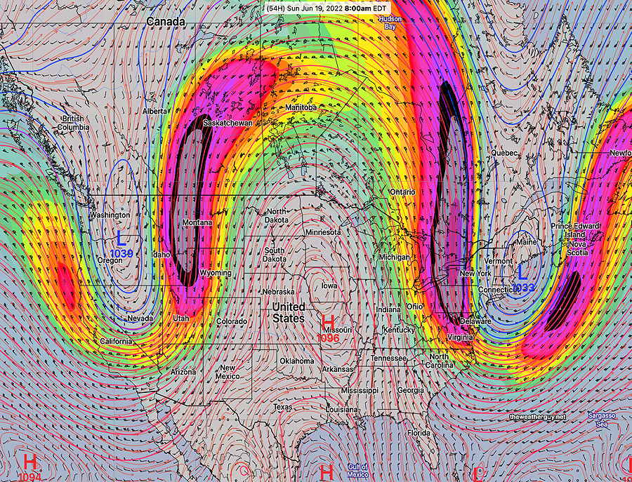
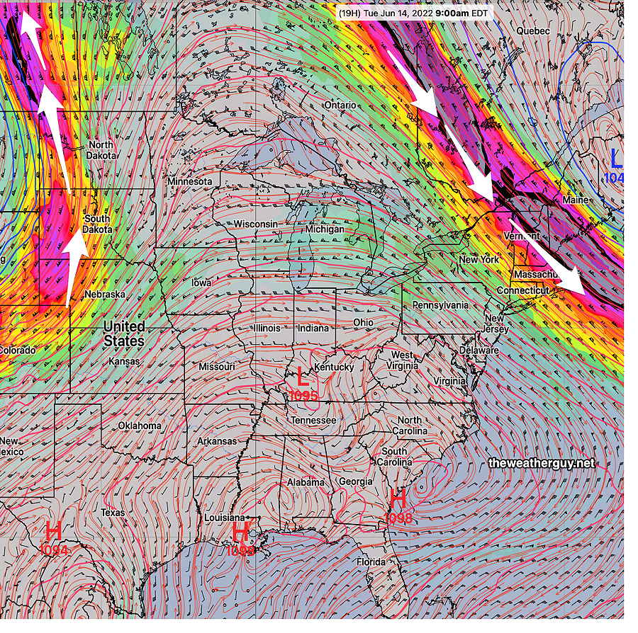
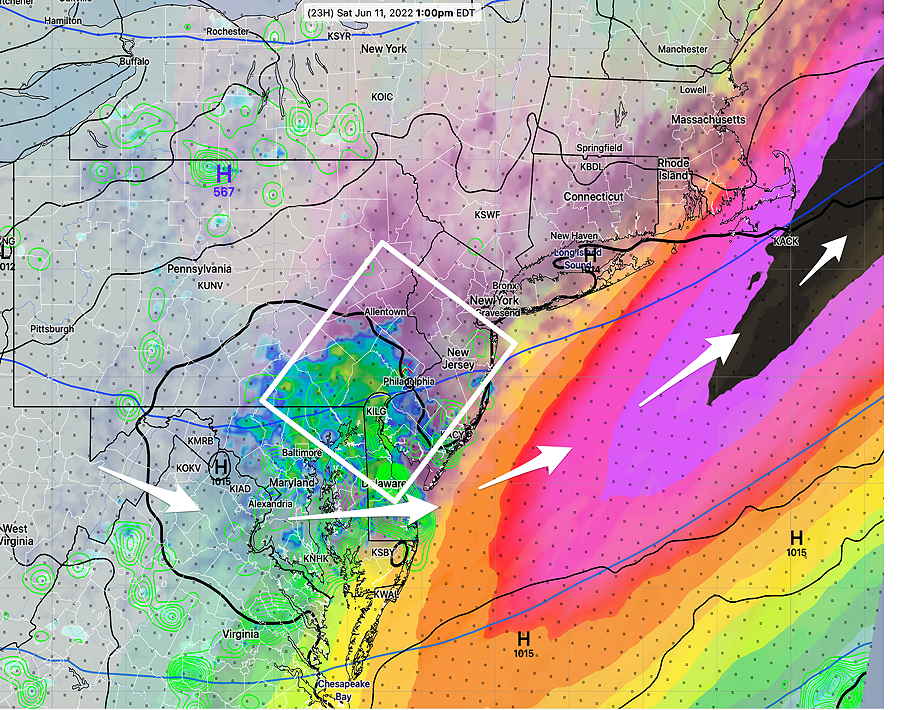
GEFS jet stream wind forecast for Sunday showing low pressure aloft in the northerast. Persistent upper ridge in the Midwest will bring very hot temperatures to that area. We’ll be in the cooler section of the pattern. (Looks like a persistent omega block appearance to me.) Will have to keep an eye on the jet streak in western Pennsylvania. This cold bring some instability cloudiness, although it’s not being forecast. (Click on image for a larger view.)
From this upper wind configuration, expect cooler temperatures, windy conditions and possibly some cloudiness (although the models aren’t forecasting any clouds here right now.)
More specific forecast info later today…
Here’s the Fri 5:59 PM update on the forecast specifics:
Saturday
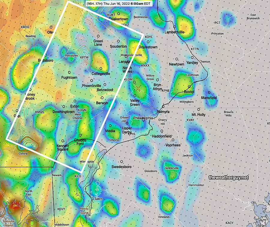
As mentioned, the above upper air setup often leads to some cloudiness. Earlier models didn’t show it, but this afternoon’s GFS, ICON and ECMWF show upper air disturbances moving through around the upper low pressure system.
Saturday will be a mix of clouds and sun. The GFS is suggesting some significant periods of instability stratocumulus both in the morning and mid day, with fair weather cumulus along with periods of sunshine other times. Somewhat windy! High temperature 70.8º ± 2.6º NBM model, Blue Bell
Sunday
Mostly sunny and delightful. High temp 75.0º ± 2.5º NBM model Blue Bell.
Forecast Review— It was just three days ago when the NAM-NEST was spectacular in forecasting thunderstorms. Not so much last night. In fact, its afternoon forecast for storms here last night was a bust.
The HREF model, which combines the NAM-NEST, HIRESW, RAP and HRRR, also was a bust.
The NBM (model blend) that is designed to blend and balance the forecast corrected for current conditions was a bust.
The NWS rescinded its tornado watch for nearby counties to our far west and northwest.
Of note, yesterday’s ICON and ECMWF were accurately forecasting no storms in Philadelphia. What can you can?
Updated Thu 9:35 PM — The latest HRRR has backed off the severe storm threat for us. In fact, it’s showing no rain! Radar shows storms losing their punch as they move towards us. Wow, what a forecast change!
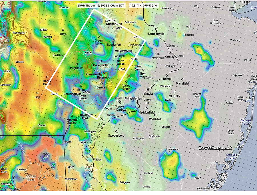
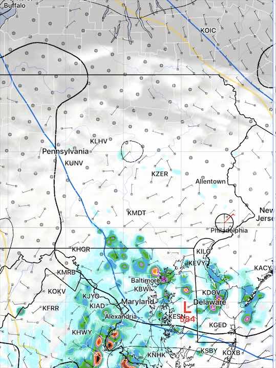
Update Thu @ 8:33 PM — As was the case last night, the “seed” for the storms tonight is visible on satellite water vapor imagery—
Water Vapor image 8:30 PM showing seed of the storms (green and red) . This will follow the path of the 500 mb winds (orange streamlines) (Click on image for a larger view.)
It should be noted that not all models are showing storms for the immediate PHL area. Some show only very scattered activity. The issue is that surface CAPE falls off very rapidly as one goes towards NJ.
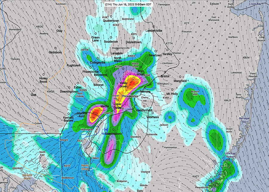
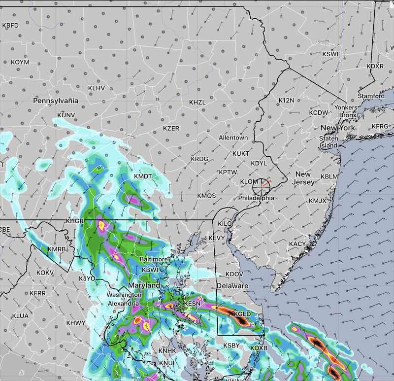
Nonetheless, the latest HREF shows some heavy rain as early as 10 PM. I’m not sure we’ll see storms that early.
Today’s 18z HREF precipitation forecast 10 PM tonight (Click on image for a larger view.)
Update Thu @ 6:14 PM — A warm front was supposed to have moved through on two previous occasions Wednesday and Thursday. One didn’t have to be a meteorologist to know that it hadn’t moved through; our temperatures and dew points today relatively low. But tonight’s the night!
The models have the warm front moving through around midnight with more showers and thunderstorms. These storms may pack a greater punch than those that moved through this morning. Indeed, there’s the possibility of severe storms.
Severity Parameters Impact: ⚑ indicates favors Severity ⚐ indicates Possible Severity ↓ indicates works against Severity
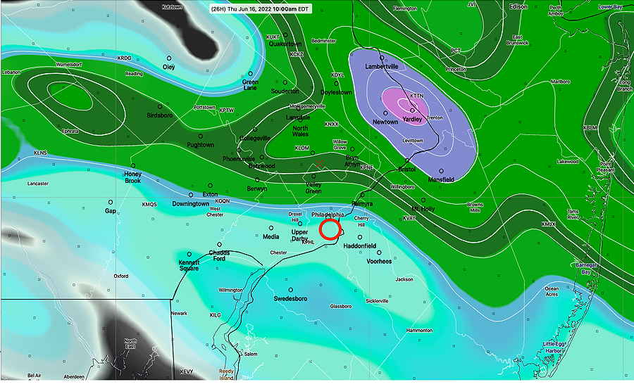
Update Thu @ 9:09 AM — Current models show that additional storms associated with a cold front late this evening will significantly diminish in strength as they approach Philadelphia.
Forecast Review— We had the storms in the time frame forecast. Close to zero CAPE assured that no severe storms developed, despite some impressive other severe parameters forecast as being moderately elevated.
Updated Wed 10:50 PM — Tonight’s early models have become available. A very interesting scenario is setting up .
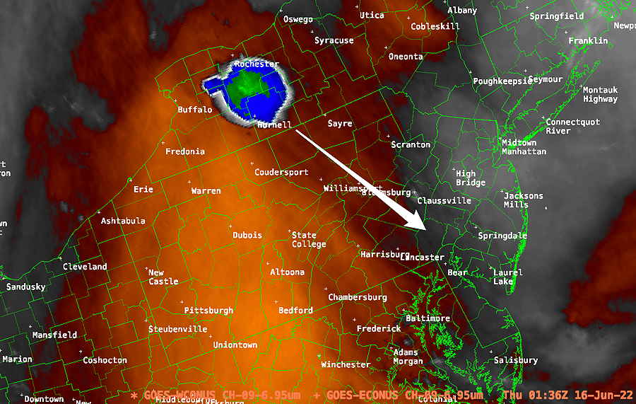
First, the seed of these potential storms shows plainly on water vapor imagery—
Strong upper air disturbance east of Buffalo on water vapor imagery in warm sector (orange) will follow upper air flow (arrow)
All models show storms developing and moving through our area between 5 AM and 9 AM. The NAM-NEST forecast suggests a bow echo storm possibility.
This is an unusual setup. There’s almost no CAPE from Philadelphia eastward. Just to our west, there’s a sharp gradient to much higher CAPE. Yet the models show very impressive storm development and heavy rain, especially west. Additionally, there’s high helicity just to our west.
Based on the severity parameters, I would ordinarily discount any possibility of severe weather Thursday morning except far western suburbs, but the models still have very strong storms forming and moving east. Tomorrow will be a learning experience for me.
Update Wed @ 5:51 PM — This afternoon’s 2 PM (18z) models have become available. All models show a disturbance dropping down in the upper wind flow, similar to Monday morning’s setup.
The rain and thunderstorms are forecast to come through between 5 AM and 8 AM Thursday morning with some models having additional isolated storms popup around 10 AM.
There is the potential for strong storms specifically in the western sections of our area. It appears the largest hazard may be brief heavy rains, although the HRRR shows elevated hail parameters and cloud tops suggestive of severe storms (??).
Last September‘sTornadoes
Thursday’s Forecast NAM-NEST (18z)
CAPE 3500-4200 Joules/kg
1400 –>50
Helicity 800-1100 m^2/s^2
360-425 ⚐
Vertical Shear 35-45
21
Precipitable Water 2.0″
1.9-2.2″
Lifted Index (minus) 7-9
minus 7 to minus 1
Peak Wind Gusts 40-50
21 mph
Aligned Storm Motion and Shear Vectors- YES
NO (↓)
Jet stream- Highly Cyclonic
Anticyclonic (↓)
Jet Stream Speed – High
Low ** (↓)
500mb – Highly Cyclonic
Anticyclonic (↓)
Higher numbers in column refer to western sections tomorrow. Severity Parameters Impact: ⚑ indicates favors Severity ⚐ indicates Possible Severity ↓ indicates works against Severity
HRRR forecast for 6 AM showing storms and elevated helicity/CAPE in the white box area. These storms will move east -southeast and weaken as they move eastward. Zero CAPE forecast for New Jersey. (their taxes are too high already) (Click on image for a larger view.)NAM-NEST Simulated Radar/CAPE/Helicity forecast for 6 AM Thursday. Elevated Helicity centers (brown-orange contours) in western suburbs. Notice no color shading (NO CAPE) in New Jersey. (Click on image for a larger view.)Canadian HRDPS 1 hour rain rate forecast 5 AM with heavy rain in Philadelphia. (Click on image for a larger view.)
The next major model runs will become available between 9:35 (HRRR) and 10:16 PM (NAM-NEST) I’ll update before 10:45 tonight.
Update Wed @ 9:55 AM — A persistent upper air pattern has been with us over the past week or so. Any change has been short-lived, as the same pattern reasserts itself. The upper ridge pattern in the middle of the country today is very similar to what it will be this weekend—
ECMWF 250 mb (summer jet stream level) winds forecast for Saturday at 7 PM. Upper ridge in center of the country with troughts in the east and west. The trough over our area will provide cooler weather (and maybe some clouds Saturday) Click on image for a larger view.)
But before we get to the weekend, a warm front moves through late tonight and early Thursday morning with clouds and some showers/possible thunderstormsearly Thursday morning—
NAM 3 hour rain accumulation forecast for 10 AM Thursday morning. Most of the rain/storms stay to our north (Click on image for a larger view.)
Clouds clear for some very warm humid weather Thursday afternoon. A cold front moves through late Thursday night. Current forecasts have most of the activity to our north with this front.
Updated Tue 9:40 PM — Uneventful weather through the weekend. A warm front moves through Thursday morning with showers. A cold front moves through Thursday night with some showers.
Beautiful weather for the weekend.
Update Tue @ 11:18 AM —
Forecast Review— My mantra “Never ignore the NAM” proved itself, despite different forecasts from the RAP, HIRESW and HRRR; my inclination last night was to ignore the NAM.
Anyhow, the heaviest activity did stay to our south, affecting the southern areas of the city, southern Chester County and southern Delaware County.
It seems that the models had trouble predicting the two centers of activity- the intense thunderstorm complex that entered West Virginia and the area that moved in around us.
Most models predicted only one center, with most latching onto the energy that went far south into West Virginia. The NAM and NAM-NEST latched onto the energy that affected our area.
Updated Tue 6:59 AM — The disturbance has evolved into two separate complexes not forecast by the models; one may hit Philadelphia shortly. One has a bow echo DERECHO appearance.
Updated Mon 10:54 PM — Of tonight’s early models, only the NAM and NAM-NEST have the rain and thunderstorms north enough to affect Philadelphia.
As shown in the previous graphics, tonight’s RAP, HRRR, HIRESW, HIRESW-MEM2, HIRESW-FV3, the afternoon HRDPS and Canadian GEM have the storms missing us and moving to our south
I’m leaning towards the storms missing us. (Or is this a scenario, “never ignore the NAM”?)
Updated Mon 9:42 PM — Tonight’s 00z HRRR just became available and supports the forecast that this disturbance will pass to our south—
Tonight’s HRRR forecast has the disturbance moving to our south, missing us.
Updated Mon 8:23 PM — The latest RAP model and Canadian High Resolution (HRDPS) has the disturbance moving far to our south on Tuesday, totally missing our area—
Canadian HRDPS forecast 11 AM Tues. (Click on image for larger view.)
So there’s uncertainty whether we’ll see anything from this small but potent system that will move from northwest to southeast.
Previously Posted Mon 6:24 PM —
A strong upper level ridge is to our west. Riding down the ridge will be a disturbance that affects us on Tuesday morning—
GFS 250 mb jet stream level winds. Large ridge extends well into Canada. (Click on image for a larger view.)
A strong upper air disturbance will develop a weak low pressure system as it slides from northwest to southeast early Tuesday morning. CAPE values are expected to be low in our area.
On, Tuesday early showers (and thunderstorms to our south and east) will move through from the northwest, ending between 2PM and 4 PM. Any heavier activity will move south of us.
HREF forecast for noon Tuesday, showing 1 hour rain combined with statistical spread. Heaviest rain in Maryland and Delaware. (Click on image for a larger view.)NBM (Model Blend) shows similar activity and track, suggesting high confidence. (Click on image for a larger view.)
Forecast Review— Except for the thunderstorms and heavy rain around daybreak, few things followed last night’s model forecasts.
The main issue was the warm front didn’t pass that far to the north; we never got into a very warm, humid unstable flow.
The periods of sunshine we got in the afternoon were forecast, but I noticed that many of the TV/radio forecasts had somehow omitted the sunshine in their forecasts.
Last night’s very neat HRRR forecast of three to four separate waves didn’t quite come to pass.
While some scattered storms developed around the late afternoon, the areal coverage was far less than forecast.
Warm fronts are often poorly handled by the models.
Some additional rain is expected overnight.
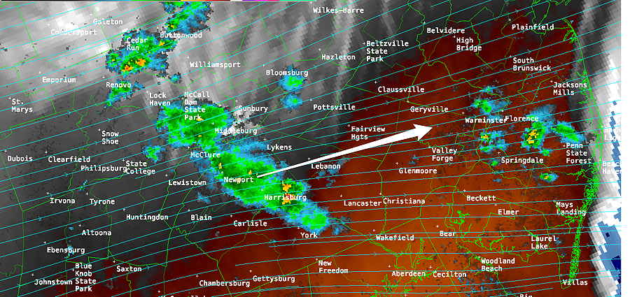
Update Sun @ 4:57 PM — We had the sunshine this afternoon and scattered storms have developed just east northeast of the city over the past hour. Additional storms associated with an upper air disturbance is moving through Harrisburg now.
Current Satellite and Radar (5 PM) with RAP 500 mb wind streamlines (Click on image for a larger view.)
The warm front barely got north of our area, so we didn’t have the higher temperatures and humidity, nor the “second batch” of thunderstorms that had been forecast early afternoon.
The latest NAM-NEST and HRRR show additional scattered thunderstorms developing around the immediate PHL area during the evening with another group of storms moving through about 9-10 PM. Heaviest activity expected northern areas—
NAM-NEST rain forecast 10 PM. Heaviest activity far north of the city. (Click on image for a larger view.)
This coming week’s weather will be interesting. And a forecast challenge.
The cold front that is moving through later tonight will stall just to our south as additional waves develop along it. Stay tuned.
Update Sun @ 9:46 AM — Based on the match up comparison of current water vapor imagery with the GFS model forecast, I’m going to lean towards the GFS in regards to cloud cover. The GFS shows a breaks of sun developing by early afternoon and lasting through the afternoon. Still some widely scattered storms around.
Next upper wave (thunderstorms), according to the GFS, is about 7-9 PM tonight. Heaviest activity northern areas.
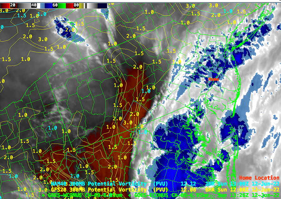
GFS potential vorticity forecast overlay with current mid-level water vapor imagery. Excellent match-up suggests the GFS is timing the impulses somewhat better than the NAM. (Click on image for a larger view.)
An interesting and complex system. Stay tuned.
Updated Sun 8:31 AM — The first round of storms has moved through. Some additional activity late morning.
I do think that we’ll see some breaks of sun developing behind the warm front after 1:30 PM. ( I don’t think that’s the NWS forecast.) Additional scattered storm activity possible with sunny breaks during the mid afternoon.
Any sun will provide fuel for strong storms later afternoon. The latest Canadian high resolution model has strong storms 4-6 PM. Additional storms this evening and as late as 3 AM Monday morning.
Later model runs will be needed to assess the possibility of any severe weather. Not seeing that right now.
Updated Sat 10:14 PM —A strong jet stream influence extends into Sunday as several upper air disturbances move through from early morning through late at night.
Several models suggest that the storms will occur in several waves.
Here’s the HRRR showing the last three rounds—
HRRR 500 mb vorticity (mid level and upper air disturbances) This shows the general grouping of the triggers of the expected thunderstorms. (Click on image for a larger view.)
First, around daybreak, a warm front will gradually lift through to our north. Showers and thunderstorms break out as early as 6 AM.
Another wave of storms with an upper air disturbance will occur late morning, possibly very strong south and east of the city.
(There will likely be some sunshine between these waves. Any sun will increase potential intensity of the storms. )
Another round of storms develop early to mid afternoon in response to some possible sun, instability and upper air disturbances.
The strongest round of storms occurs after 6 PM through midnight as a cold front approaches from the west. This round of storms could be have severe elements, as CAPE values increase and areas of helicity and shear add to the mix.
This final round may last well past midnight as the front will be slow to move through and additional waves develop along it into early Monday morning.
An interesting day, weather-wise. Stay tuned.
Update Sat @ 9:50 AM — My prior 8:08 AM update broke the cardinal rule of weather forecasting: Never create/update a forecast without first wchecking current radar and satellite imagery.
The latest MRMS shows showers in western suburbs rapidly moving up northeastward—
MRMS 9:28 AM (Click on image for a larger view.)
The latest HRRR (12z) just became available shows scattered showers at 1 PM however these showers will be VERY LIGHT in our area (0.01-0.02″) —
HRRR 12z simulated radar at 1 PM (Click on image for a larger view.)
Last night’s original forecast and HREF graphic is looking more like the right call with showers moving in late morning into early afternoon. Still a low confidence forecast.
Updated Sat 8:08 AM — Today’s ”lower confidence” forecast is living up to its billing. The upper level lift appears to be less even successful in setting off surface rain.
The latest RAP ensemble (NARRE Model) shows very light amounts of rain, mostly far southwest of the city and eastward at the shore mid to late afternoon. Many areas dry and any rainfall amounts very light where showers do develop.
RAP ensemble forecast for 4 PM showing accumulated rain. Green contours are 0.02” rain (click for larger image)
Updated Fri 8:22 PM — Updated the Sunday forecast below.
As discussed in earlier “This Week’s Weather” the weekend forecast will be heavily influenced by departure and approach of jet stream wind speed maxima (called jet streaks). These changes in speed and changes in direction cause vertical motion leading to clouds and rain (if moisture is present)
Since jet stream motion can’t be measured as often and accurately as surface based parameters (humidity temperature, pressure), jet stream-dependent weather systems have inherently lower confidence in details.
Saturday
Such is the case on Saturday where a departing jet streak and sharp curvature of the jet level winds will result in showers. Previous models showed some sun on Saturday. The latest HREF shows little in the way of sun during the day.
Lastest HREF forecast showing jet stream flow, jet streak (black) and simulated radar forecast at 1 PM (Click on image for a larger view.)
Saturday will be mostly cloudy in the morning. Showers move in between 12 and 1 PM from the southwest. Tonight’s HIRESW shows the very light showers dissipating as they move north, and more sunshine in the afternoon. Partial clearing skies late afternoon about 3-5 PM. High temperature 76.1º ± 3.5º (high spread/high uncertainty) Blue Bell, PA
Sunday
A warm front will move towards us as a another strong jet wind maxima approaches.
Areas of vorticity develop in a correspondingly active area of this jet streak. However, this time we’ll be in a much more dynamic section of the jet streak. Expect thunderstorms, likely strong during the day and especially late afternoon and early evening. Heavy rains likely with the later storms.
Updated Fri 8:22 PM — Afterreviewing several other models, it appears that showers may begin as early as the morning hours Sunday.
The NBM paints a very cloudy and rainy/unsettled period throughout the day and evening.
High Temp 77.7º ± 2.3º NBM model, Blue Bell.
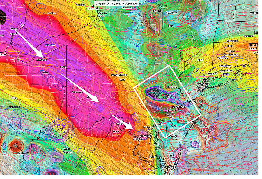
Today’s 18z NAM shows approaching jet streak on Sunday with areas of strong adjacent positive/negative vorticity (white box) at 5 PM. Heavy rain, strong thunderstorms likely. (Click on image for a larger view.)
I’ll be updating this over the weekend. Stay tuned.