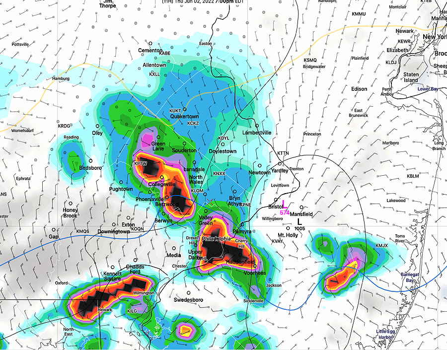
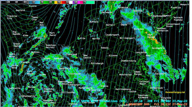
Update Thu @ 5:13 PM — Thunderstorms have broken out as expected with one or two severe warnings in effect. Most of the activity has been typical thunderstorms. The latest satellite imagery shows another impulse approaching from the southwest and may trigger more storms, especially from Philadelphia, south and east.
Update Thu @ 9:24 AM — Reviewing last night’s models and the new models coming available this morning. A cold front moving down from the northwest will develop a wave along it; low pressure directly over our area (or just to our south according to the latest models) will enhance rainfall and thunderstorm potential.
HRRR: Thunderstorms develop 2-5 PM far northwest areas and move southeastward, reaching Philadelphia suburbs and Philadelphia between 4:30 and 7 PM. Additional thunderstorms and showers develop dynamically in-place due to developing low pressure lasting through midnight.
RAP: Scattered storms break out as early as 3 PM in our immediate northwest suburbs. Main activity here 4-6 PM. Additional showers/thundershowers through midnight.
Current severity expectations is “marginally severe possible.”
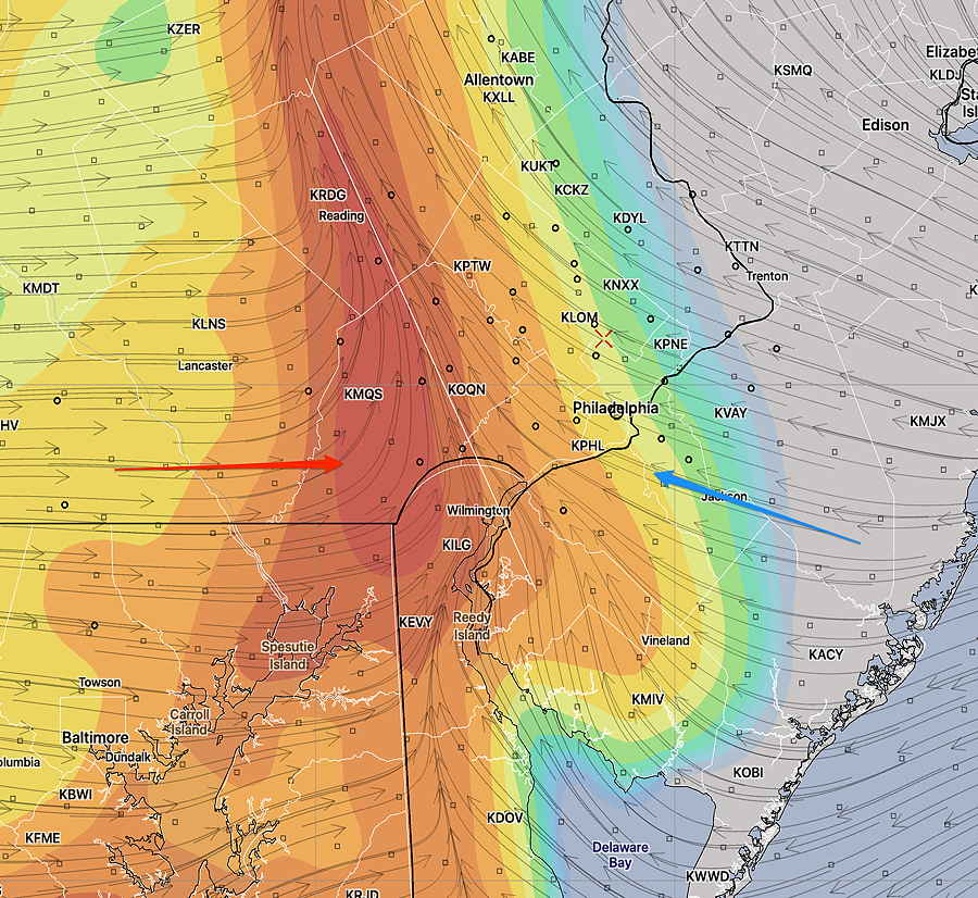
HRRR forecast showing low pressure over New Jersey at 7 PM (Click on image for a larger view.)HRRR Shear forecast at 7 PM tonight. Peak shear is around 30 (darker orange) (Click on image for a larger view.)
Severity Parameters Impact: ⚑ indicates favors Severity ⚐ indicates Possible Severity ↓ indicates works against Severity
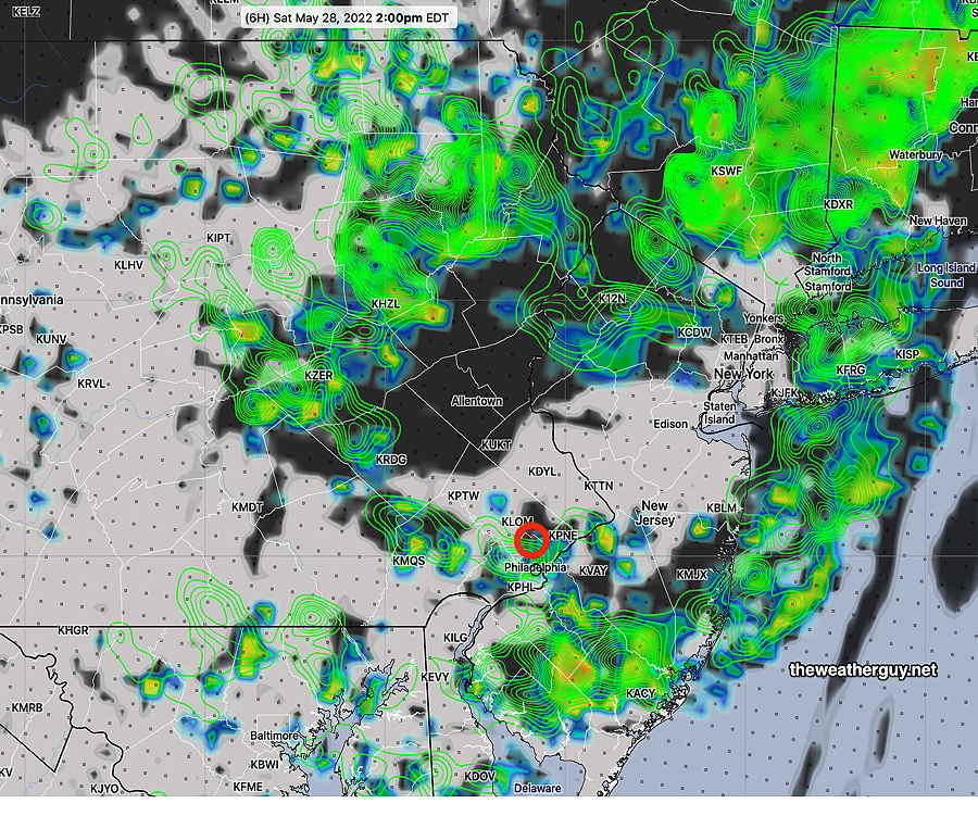
Update Wed @ 8:30 PM — The front made it to Lancaster county during the daytime and barely moved back eastward. Around Philadelphia, an easterly flow kept things cool. Thunderstorms developed northern Chester County (Phoenixville area) this afternoon and again this evening. The evening storms were very slow moving and based on radar, they dumped a lot of rain in a small region. They attempted to move eastward, but ran into high CIN and fell apart.
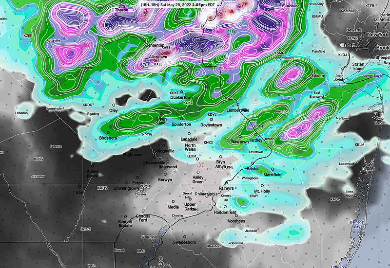
Additional storms in the Allentown area may move through here around midnight.
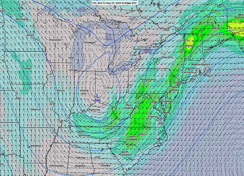
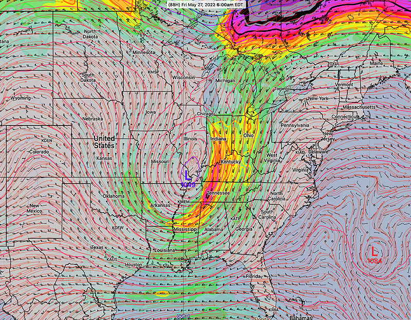
Thursday is shaping up to be an interesting day weather-wise as most models have consistently forecast the development of a low pressure system directly over us late afternoon. An approaching front and low pressure could result in heavy rains. Right now scattered storms look to begin about 2 PM in western areas and move into the Philadelphia region by 4-6 PM. I’ll post something about intensity of these storms tomorrow morning.
NOAA is doing a live test of their new supercomputers for the next 24 hours. All models today are coming off of this new system. I’ve never seen their servers so fast! Another live test in two weeks and then it becomes fully operational on June 28th.
So where are all these models on the web? Here on the NOMADS site. (Warning: The NOMADS site is somewhat intimidating and designed for extreme weather nerds and professionals only.)
Updated Wed 7:33 AM — Current weather analysis (RTMA) shows the front only made it as far westward as Chester county, not Lancaster county as predicted by last night’s models.
This boundary is expected to move back eastward today and the convergence zone of the winds (see graphic below) will be a focal point for showers and some thunderstorms. Lowered CAPE values and high CIN values show any activity to be garden variety thunderstorms and showers later this afternoon and this evening.
Updated Tue 11:06 PM — Tonight’s models show the backdoor cold front moving as far westward as Lancaster county. Most models have very little storm activity during the afternoon as CIN values remain high. Some models (but not all) have storms redeveloping in the late afternoon and evening and moving in from the northwest as the wind convergence zone moves back eastward. Some of these may be strong. I’ll update tomorrow.
Updated Tue 6:11 PM — This afternoon’s models, particularly the HRRR, has the backdoor front moving so slowly back eastward that conditions near Philadelphia are not as unstable as shown in the table below. Less instability means less activity is likely in the immediate PHL area on Wednesday. So forget about the green severity table below for now.
Indeed, the latest RAP shows elevated ”CIN” during the afternoon. (Think of CIN as opposing CAPE.)
RAP forecast CIN at 2 PM (Convective Inhibition) is elevated right where thunderstorms had previously been predicted to form. (Click on image for larger view.)
Any activity is predicted to from in the far northwest (Reading – Allentown area) and far western suburbs. The NAM-NEST continues with some storms making it into our area, but they diminish in strength as they move through. Any storms will be scattered; this will not be a line of storms. Should the backdoor front change its forecast position, this forecast will change.
Heavier storms still expected Thursday evening.
Updated Tue 11:34 AM — The backdoor cold front boundary, expected to stall just west of Philadelphia on Wednesday, will gradually move back eastward during Wednesday afternoon. Areas of moisture convergence and high CAPE will result in some heavy thunderstorms in some areas later Wednesday afternoon.
Last September‘s Tornadoes
NAM-NEST Wednesday Forecast
CAPE 3500-4200 Joules/kg
2000-4000
⚑
Helicity 800-1100 m^2/s^2
200-300
⚐
Vertical Shear 35-45
10-15
Precipitable Water 2.0″
2.0″
⚑
Lifted Index (minus) 7-9
minus 6-9
⚑
Max 700mb Vertical Motion 110 m/sec
70
⚑
Peak Wind Gusts 40-50
17
Aligned Storm Motion and Shear Vectors- YES
NO
Jet stream- Highly Cyclonic
Flat
Jet Stream Speed – High
Low
↓
500mb – Highly Cyclonic
Anticylonic
↓
Severity Parameters from Tuesday’s NAM-NEST model for Wednesday afternoon ⚑ indicates high severity ⚐ indicates Moderate Severity ↓ indicates works against severity
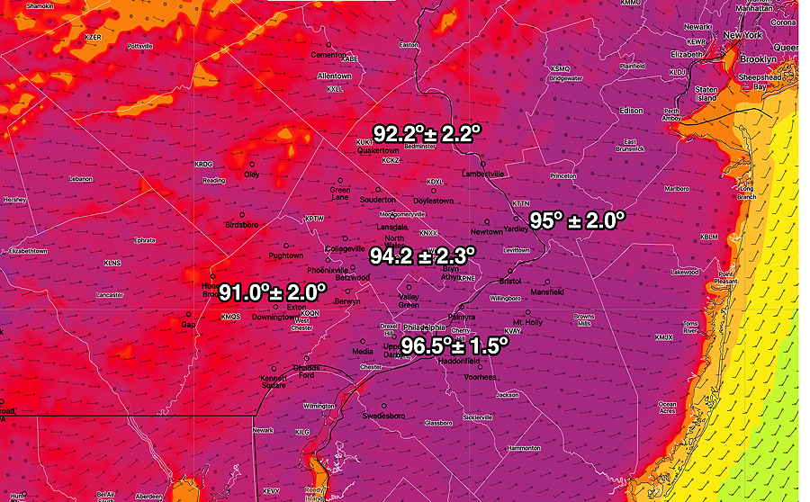
Update Tue @ 8:35 AM — Temperatures are still expected to be in the range shown in last night’s post, perhaps 1 degree less overall.
A weak backdoor cold front is still expected to move in before daybreak Wednesday morning. Here’s the RAP model position of the front—
RAP model shows backdoor cold front moving through to western suburbs of Philadelphia Wednesday. Cooler temperatures east of the front. Some models have this front moving back eastward, allowing hot air to return Wednesday afternoon, but there’s lack of clarity how far back this front will move. (Click on image for a larger view.)
There’s a lack of agreement about how far the front will move back eastward and how much hot air will return Wednesday afternoon. A large gradient in temperatures across this boundary.
Originally Posted Mon @ 7:40 PM —
A strong upper air ridge will bring very hot temperatures to our area on Tuesday. The latest NBM model shows maximum temperatures to be higher than previous forecasts—
Today’s 19z NBM Maximum Temperatures for Tuesday. (Click on image for a larger view.)
With dew point temperatures in the range of 65-67º, Tuesday will feel uncomfortably hot.
From Wednesday through Thursday, a back-door cold front will gradually sink closer to us from the northeast
With more clouds, Wednesday’s highs may not reach 90
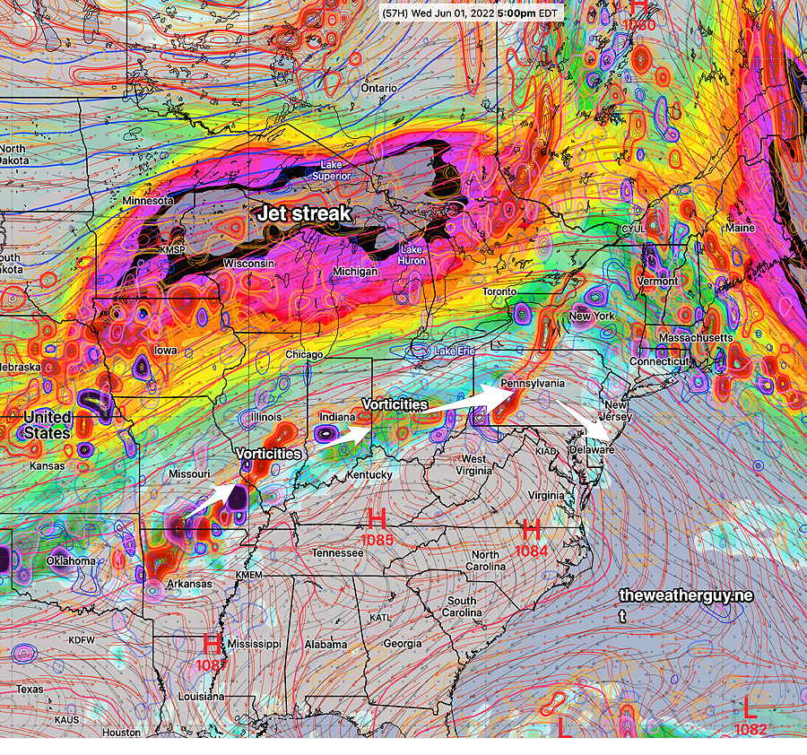
Some showers/thunderstorms may break out Wednesday ahead of some upper air disturbances (areas of vorticity) rotating around the upper ridge. Additional activity far northwestern suburbs late Wednesday afternoon.
GFS jet stream forecast for Thursday 5PM shows jet stream (jet streak- area of maximum winds) with areas of vorticity moving through into our area. (Click on image for a larger view.)
From Thursday into early Friday, a cold front will approach closer with low pressure developing along the front. Some thunderstorms and rain will break out, especially late Thursday afternoon and evening. Exact timing and details vary from model to model. Several models have some fairly heavy rain later Thursday.
Things clear later Friday and the weekend looks pretty good.
Update Sat @ 10:45 AM — The latest models show more showers developing early afternoon than previous forecasts. I’ve been waiting to decide on a bike ride today; not sure if I want to get rained on. Today’s forecast has been a moving target and a challenge all of this past week.
HIRESW model 2 PM forecast shows areas of sun (no clouds) pop up showers (and clouds= black) developing and moving through from the northwest during the afternoon. (Click on image for a larger view.)
Updated Sat 8:48 AM — Last night’s 06z models keep the showers for the most part, far northern areas today, even a little further north than last night’s NAM-NEST update graphic immediately below. The original forecast still holds.
Update Fri @ 11:09 PM — The second batch of storms has entered our area tonight as forecast. The several rounds of storms may move through before 5 AM.
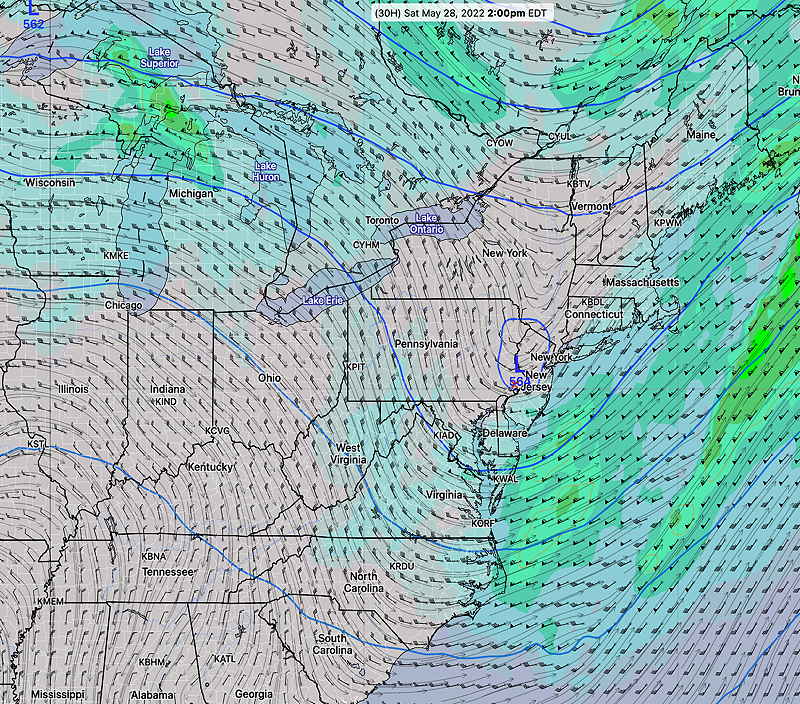
For Saturday —Tonight’s models have the upper low closing off around mid-day Saturday. As a result, more showers are expected, especially north and northwest of Philadelphia during the mid day and early afternoon Saturday.
Tonight’s NAM-NEST captures it —
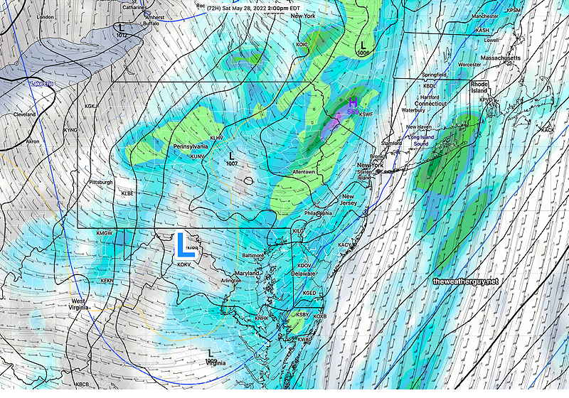
Tonight’s NAM-NEST forecast for 2 PM Saturday showing 1 hour prior rain accumulation and clouds (dark). The heaviest rain is north and northwest of the city. (Click on image for a larger view.)
Previously Posted Fri 5:53 PM —
Those of you who regularly read this site have known there has been uncertainty with this weekend’s forecast, specifically Saturday’s forecast; a closed upper air low correctly predicted by the GFS as early as last weekend has undergone every conceivable forecast permutation. The ECMWF and the GFS have traded places over the week with forecasts of a closed low and open low.
As of 4 PM Friday, the closed low is clearly visible on radar image—
Friday 4 PM radar with superimposed RAP 500 mb wind streams. (Click on image for a larger view.)
The GFS model forecast pretty much lines up with the current situation (as does the ECMWF) —
Friday’s 12z GFS forecast for the same time as the radar image above. (Click on image for a larger view.)
This closed low was expected to “open” as it moved over Pennsylvania Friday night.
"Closed" upper air low
"Open" upper air low
Unfortunately, the GFS (but not the ECMWF) closes it off again Saturday afternoon!—
GFS 500 mb wind forecast at 2 PM Saturday. Closed low over PA/NJ.
Since the GFS has been the [relatively] consistent about the closed low forecast and because it is supported by the latest GEFS, I’m inclined to lean towards its forecast for Saturday. However, the latest NAM opens the low and has a more optimistic forecast.
A closed low would mean more unsettled weather for Saturday throughout our area. The open low means that mainly areas north and northwest of the city would have showers. So Saturday’s forecast still has a lower than usual confidence.
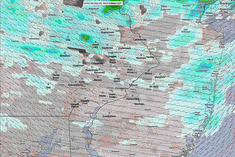
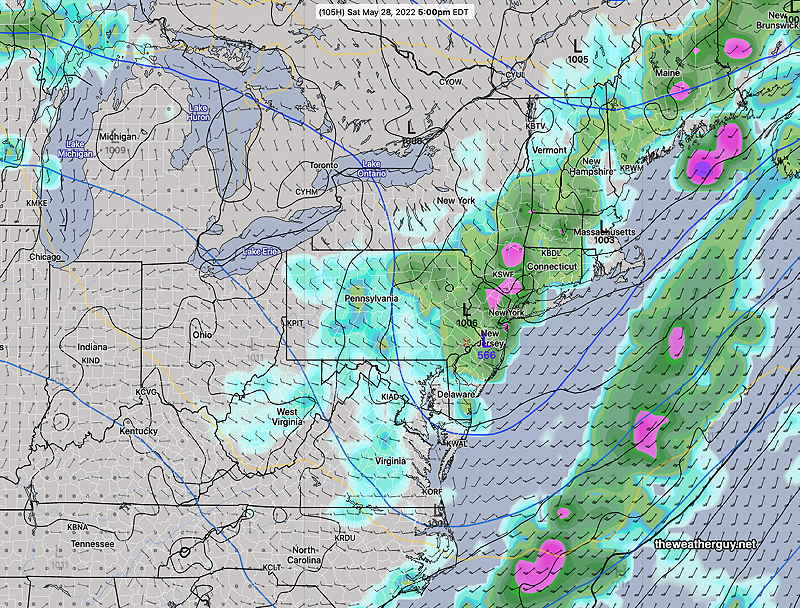
Friday’s 19z NBM (model blend) forecast (blue green = rain; red contours= clouds) for 1 PM Saturday. (Click on image for a larger view.)
Saturday
A mix of clouds and sunshine. Showers likely during the day north and northwest of the Philadelphia area. Some showers may sneak into Philadelphia. (Southern NJ looks much better- probably no rain.) High temp 77.4º ± 2.0º NBM model, Blue Bell
Sunday
Mostly sunny and warmer High 81.3º ± 1.3º NBM model, Blue Bell
Monday
Sunshine through high cirrus clouds (in the morning) and very warm. More humid. Dew points in the low to mid 60s. High 88.8º ± 2.0º NBM model, Blue Bell
Update Fri @ 5:04 PM — Not much in the way of strong storms or severe weather in our immediate area. (Although severe weather was picked up on radar in NJ.) The amount of rain so far has been less than forecast. More showers expected later this evening and around/after midnight.
Update Fri @ 9:44 AM — Latest HRRR and RAP have converged on a peak time for storms to start: about 3 PM, earlier in western areas.
Update Fri @ 9:10 AM — Reviewing the latest hourly models, the previous forecast time frame for showers and thunderstorms has remained unchanged in our immediate area: a large range of time, from 2 PM to well after midnight.
Based on helicity values and storm motion/shear vectors, the strongest storms appear to be most likely this evening, after 5:30 PM, although CAPE values are already high at 2 PM.
Different severe parameters and factors peak at different times. There’s a strong jet stream influence later in the evening after midnight.
The severe parameter values are similar to those shown in my severe parameter table from last night.
As was my forecast last night, these storms can be strong. I don’t expect severe weather, but I’m sure the NWS will issue severe storm watches and warnings. Base your plans on the NWS.
As for this weekend’s weather, this has been an especially challenging forecast, especially for Saturday, with models having inconsistent and shifting forecasts from day to day. The upper low has been hard to pin down. The ICON, whose forecast had been totally dry for Saturday has added showers and even some thundershowers for mid-day Saturday. Indeed, several models have a mix of sun, clouds and convective showers (thundershowers) during the morning and early afternoon.
I’ll post the weekend forecast this evening.
Updated Thu 11:30 PM — Tonight’s models continue with forecast from the earlier RAP— showers and thunderstorms develop late morning/early afternoon Friday and continue through at least midnight.
Several batches of storms during this period— Some late morning activity possible to start things off —then early afternoon (2PM) and some potentially stronger storms 6-9 PM. Another batch around midnight. Some models have some showers even Saturday morning before the major clearing trend starts for the balance of the Memorial Day weekend.
Updated Thu 7:38 PM — Prior to what’s shaping up to be a rather nice weekend, we’ll have to get through Friday.
An approaching upper air trough will trigger the development of showers and thunderstorms on Friday. My table of severity parameters below compares tomorrow model forecast (RAP) to what has become my standard of extremes- last year’s (9/1/21) tornadic storms.
Last September‘s Tornadoes (9/1/21)
Fridays Storms RAP 21z Model
CAPE 3500-4200 Joules/kg
1200
Helicity 800-1100 m^2/s^2
350
Vertical Shear 35-45
16-20
Precipitable Water 2.0″
1.8″
Lifted Index (minus) 7-9
minus 5
Peak Wind Gusts 40-50
35
Aligned Storm Motion and Shear Vectors- YES
YES (early)
Jet stream- Highly Cyclonic
Flat to anticyclonic
Jet Stream Speed – High
Moderate
500mb – Highly Cyclonic
AntiCyclonic
As you can see, the current severe parameters are in the middle range. I expect some strong storms tomorrow. I’ll use the disclaimer that severe weather is always possible with thunderstorms, but I don’t expect much in the way of severe.
What appears to be the most important aspect of tomorrow’s storms will be the extended time frame that scattered stormsdevelop and move through.Some early activity late morning, the bulk of the activity from about 2 PM to midnight.
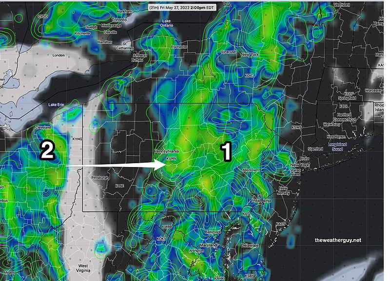
This afternoon’s 21 RAP model radar/accumulated rain forecast at 2 PM Friday. Large area of rain (1) for the afternoon. A second batch of rain (2) catches up and moves in around midnight. (Click on image for a larger view.)
Update Thu @ 8:47 AM —This week’s ever-changing weekend forecast has moved in a very positive direction. The slow moving “closed low” that had been forecast by the GFS and then the ECMWF is now forecast to “open up” on Saturday and move off to the northeast. ( A very different forecast from the past two days, but not too different than the ICON’s forecast which has consistently predicted for us to have a good weekend.)
The forecast transition from a “closed” upper low to an “open” upper low will occur Friday night and this transition improves our weather for the entire weekend—
"Closed" upper air low
"Open" upper air low
As a result, Saturday is looking to have more sunshine, with significantly less chance of showers, especially by the afternoon. Sunday and Monday look very good.
Updated Wed 7:32 PM — Reviewing some of the other models, it appears that Saturday will have a mix of sun, clouds and pop-up showers throughout the day. More sunshine, less clouds and significantly reduced chance of showers Sunday. Mostly sunny Monday.
Update Wed @ 5:13 PM — Today’s GFS and ECMWF models are in reasonable agreement with forecasts for rain Friday and portions of Saturday. Both models have partly cloudy/partly sunny skies on Sunday and sunny on Monday. The Canadian GEM Global model and the NAM has a similar forecast for Saturday.
The ICON model continues its forecast for mostly sunny for Saturday through Monday.
With three major models showing rain on Saturday, I can’t explain why the NBM (Model Blend) and shows no rain and little in the way of cloudiness Saturday through Monday.
I think the GFS has performed the best over the past week in predicting the upper closed low with lingering clouds and showers. I would expect some rain on Saturday and improving conditions Sunday and Monday.
Today’s 18z NAM cloud/precipitation forecast for 2 PM Saturday. (Click on image for a larger view.)
Update Wed @ 8:06 AM — The weekend forecast continues to be low confidence as the GFS has reverted back to an upper level closed low lingering in the area (now to our south) through Monday while the ECMWF has the closed low opening and lifting away by late Sunday.
The new GFS model has the low moving east southeast instead of northeastward, bringing us a cool northeasterly flow.
We’re talking about occasional/intermittent showers, some sun, significant periods of cloudiness and cool temperatures, not a soaking rain.
Monday looks to be the best day.
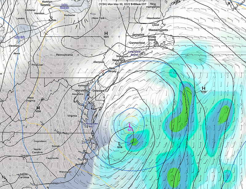
GFS forecast for 5 AM Monday showing closed upper low (Purple L) and weak surface low (-L black isobars) off Carolina coast. (Click on image for a larger view.)
Updated Tue 5:42 PM — There’s been an increase in uncertainty around the weekend forecast with the major models doing a reversal of their forecasts from yesterday. The ECMWF now has the upper low pressure system lingering through at least Saturday, while the GFS moves it out faster.
Regardless of the model, most of Sunday and especially Monday, appear to be very nice days. Saturday has the most uncertainty in the forecast with a possibility of lingering showers.
The ICON and GFS are currently the models with the most optimistic forecasts at this time, but a lack of forecast continuity still makes it low confidence.
Here’s the ECMWF forecast for late Saturday showing lingering rain —
Today’s 12z ECMWF forecast for 5 PM Saturday showing the upper low over eastern Pennsylvania/Nj with lingering showers and clouds. (Click on image for larger view.)
Here’s the latest GFS forecast showing clear skies for Saturday—
Latest GFS (12z) showing sunny skies for Saturday. (click on image for larger view.)
We’ll likely have to wait at least another day or so before the forecast is more predictable.
Previously Posted Mon 8:05 PM —
The models are showing an interesting narrow upper air trough in the middle of the country mid week that may or many not close off into closed low over the Ohio Valley.
Most of the shower activity through Thursday will remain south of our immediate area. But some degree cloudiness will affect us Tuesday through Thursday before rain moves in Friday.
Today’s 18z GFS jet stream (250 mb) forecast showing deep, closed jet level low pressure system over the the Mississippi Valley. (Click on image for a larger view.)
For the weekend, there’s a lack of agreement between the GFS, ECMWF, ICON, and CMC regarding the upper trough and closed upper level low. The GFS has a slow, closed low forecast which would adversely affect this coming weekend’s weather, while the other models open up the low and move it off the coast. It’s too early to tell which is correct and we’ll have to follow the model trends for the next few days.
The most optimistic forecast right now: Friday looks to be rainy, sunny Saturday, Sunday into Monday—
Today’s 12z ECMWF optimistic forecast for early Saturday morning. (No closed upper level low) (Click on image for a larger view.)
Unfortunately, the latest GFS maintains that closed low through the weekend with plenty of showers. Again too early to hang our hats on the pessimistic GFS—
Today’s 18z GFS pessimistic Sunday forecast. Closed low over Pennsylvania Plenty of rain and clouds. (Click on image for a larger view.)