WEATHER UPDATE

[su_note note_color=”#defcdc”]Sunday 12 PM Update: This morning’s models have become available. The trends—

Less QPF is expected today, rain amounts reduced from 1 inch to about 0.6 inches water.

For Monday, temps in the upper atmosphere support snow fallling during the afternoon, but surface temperatures remain too warm until evening.

The upper atmosphere cools after 2 AM tonight and any precip will fall as rain >> snow by afternoon.  The lower atmosphere temps are slow to chill down, complicating accumulation forecasts.

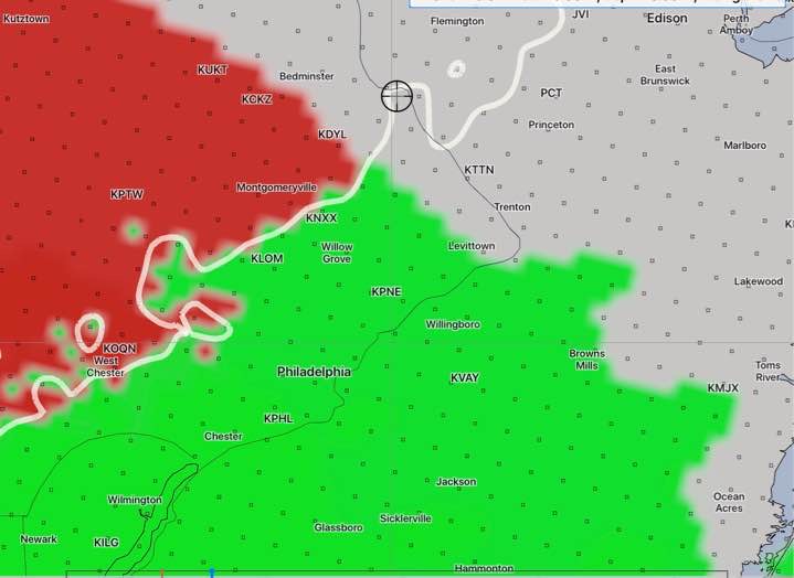
The NAM has a coating up to 1 inch (with the lower range more likely) by late Monday evening.  The GFS has surface temperatures too warm for any accumulation in PHL and the immediate suburbs. 

For snow, I tend to go with the NAM. 
[/su_note]

[su_note note_color=”#defcdc”]Sun 7:30  AM Update:  The 1 AM run of the GFS and NAM has moved the start of the precip to about 9 AM.  The latest HRRR depicts the freezing rain  further north and west —

HRRR PTYPE forecast for 9 AM Sunday

As I said yesterday, with the precipitation onset being revised each model run suggests that the models are having difficulty with this storm’s forecast. 

That said, my rule of thumb — when the models are having trouble with the very short term forecast, it puts into question their forecast for the following day. 

The models are still predicting a mix of rain and snow during the day and evening Monday, significantly more snow to areas north of Doylestown.  Last night’s ECMWF is all on-board with that forecast.  Can we really trust it with Monday’s forecast?   Stay tuned.

[/su_note]

…from last night—

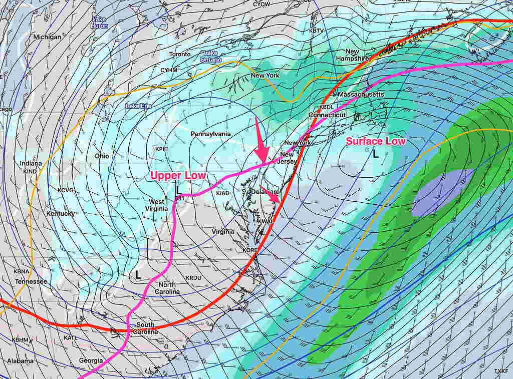
Earlier this week, I described this weekend’s weather as “interesting” and indeed it is a complex scenario involving a secondary coastal low pressure system and an upper atmospheric low that will interact in complex ways. See my previous discussions about the systems involved, as the general scenario appears to be playing out as predicted.  Here are the latest model trends —

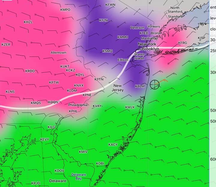
Freezing rain and sleet begins 5-7AM from the city just north and west, and changes to all rain from 9 AM to noon. The city proper, south and east will have mostly rain. Areas north and west will have a prolonged period of sleet and freezing rain.  The graphic below is the latest NAM model forecast of PTYPE.

NAM forecast for 10 AM Sunday. Green rain, red freezing rain, magenta sleet. White line is surface freezing temp

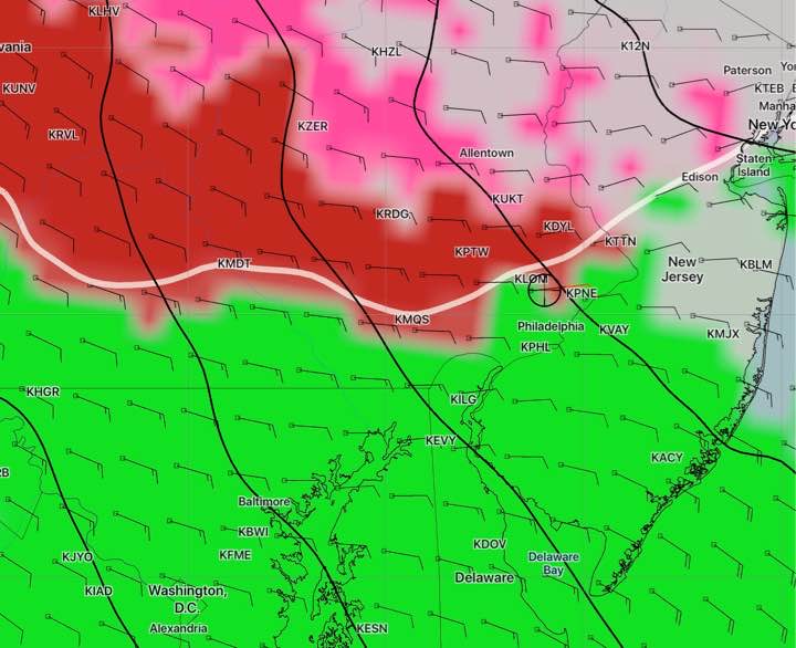
The other models are in general agreement.

After the changeover, rain heavy at times is expected. QPF values about 1 inch water.

Sunday night, cold air filters in in the upper atmosphere.

For Monday —An upper low trailing the surface low will bring additional precipitation on Monday. A changeover to snow and snow showers is expected during the day, however for the immediate PHL area and adjacent suburbs, surface temperatures remain above freezing until late afternoon, so accumulation will be highly limited here. Currently, the models are showing a coating to an inch by the time it ends late Monday night, with considerably more in far northwest counties.

There remains uncertainty about this Monday’s snow. Stay tuned.


WEEKEND WEATHER FORECAST

[su_note note_color=”#defcdc”]Sat 5PM Update: Current Trends: Precipitation starts later, about 7:00 AM Sunday.  Several hours of light sleet and freezing rain possible before changing to rain  late Sunday morning.  Far north and west will have extended sleet/freezing rain.

There have been ongoing changes with the onset of the precipitation, suggesting the models are having trouble with this complex surface and upper air system.

For Monday, still a coating of snow for PHL and immediate counties north and west on Monday.  Areas north of Trenton and Doylestown will have more— potentially a few inches of snow on Monday.  I’ll update later this evening. [/su_note]

…from Sat morning:

[su_note note_color=”#defcdc”]Sat AM  Update: After reviewing last night’s model runs, here are the current trends— For Sunday morning, all models show a period of sleet and freezing rain until about 10 AM Sunday morning,  longer duration far northwest.  Below, the SREF (Short Range Ensemble Forecast Model) shows sleet/freezing rain in magenta, snow in purple, rain in green.

SREF model 7 AM Sunday Categorical PTYPE (precipitation type).  White line is freezing line at surface (actually measured 6 feet above ground).

The rest of Sunday, we’ll have rain, heavy at times.

Still uncertainty about Monday, especially Monday evening. The SREF, NAM and ECMWF (European) have light snow with a coating of accumulation possible, more north of Allentown. The GFS and the CMC (Canadian) have snow showers, very light and scattered, no accumulation in our area.  I’ll continue to update again this weekend.

[/su_note]

…from Fri evening—

The latest models have come in.  Based on the latest NAM, NBM and WRF,  there are some changes in the forecast.  The background for the weather this weekend is discussed in previous posts.

Saturday will be dry.  Some sun early with high, thin cloudiness increasing throughout the day. Lower level clouds move in later in the afternoon  than previously forecast. Very light winds. High 44.

About 3-5 AM Sunday morning, precipitation starts, likely as sleet, freezing rain and wet snow mixed in.  After daybreak Sunday, sleet continues and mixes and changes to rain during the morning.  Some freezing rain possible north and west early.  Driving may be affected early. Tonight’s WRF models have freezing rain/sleet until mid morning.

Rain, heavy at times Sunday. High 45.

A secondary low may linger and intensify off the coast on Monday, with cold air changing precipitation to wet snow on Monday and Monday evening. Still unclear if there will be any accumulation, but a coating to 1 inch possible by Tuesday morning.

WEEKEND WEATHER OUTLOOK

[su_note note_color=”#defcdc”]Fri Late Afternoon Update: The forecast for the weekend remains on track.  I’m updating because the Monday forecast period now falls into the range of the NAM model.

For Monday: The latest NAM model supports the scenario discussed as a possibility over recent days— a secondary coastal surface low is held back or regenerated along the coast due to the upper atmosphere low pressure system to the west playing catch-up with the surface system.

Once they come together and become “vertically stacked”, the coastal system will further intensify.  This setup allows the collision of cold air and wrap-around moisture to create the chance of snow Monday afternoon and evening over our area.  About an inch  is a possibility by daybreak Tuesday morning, although warm surface temperatures may interfere with accumulation.   I think there’s still uncertainty about the amount of snow on Monday and I expect better clarification over the weekend.  Stay tuned.

NAM forecast for 1 AM Tuesday showing Simulated Radar and Critical temperatures supporting snow.

[/su_note]

…from Friday morning—

[su_note note_color=”#defcdc”]Fri AM Update: There’s still uncertainty with the forecast for Monday.  As mentioned over past days, the strong upper atmosphere low remains west of the surface low on Monday.  Precipitation lingers while the “critical thickness” levels indicating lower level/upper level temperatures supporting snow  moves to our south and east, allowing a change from rain to snow.

So the possibility of light snow or snow showers on Monday still a possibility.  A range of warmer surface temperatures may keep us from getting much, if any, accumulation.   Below is the SREF (Short Range Ensemble) “statistical mean” forecast.  Stay tuned.

SREF Forecast for Monday at 6:45 AM showing critical thickness and upper/ surface low pressure systems.  Critical thckness for snow shown as red and magenta lines.  Green blue shading is precipitation.

[/su_note]

….from Thursday night:

Happy Thanksgiving!

A wet and windy Sunday….

The trends mentioned in the previous posts continue.  A deep low pressure system will spawn a secondary coastal low late Sunday as the upper atmosphere low pressure system hangs back.

Saturday will be dry.  Sunny in the morning with increasing cloudiness expected by early afternoon.   High 48.  Precipitation, originally forecast to start Saturday afternoon is further delayed until the hours before daybreak Sunday.

For Sunday, precipitation will be rain, heavy at times.  QPF values around 1 inch of rain.  There is a possibility the the precip starts as wet snow before daybreak but warm temps will change everything to rain.  High 43.  It will be windy.

The deep low pressure will intensify off the coast. Colder air will be brought in before daybreak on Monday.  There is the chance of change back to wet snow at that time. No accumulation is forecast by the models.

Monday will be cloudy, windy and colder. High 40. The upper atmosphere low and the coastal low will combine to our east.  The models are forecasting snow showers during the day Monday, but surface temperatures will be above freezing.  Little or no accumulation is forecast by the models.

I think there’s some uncertainty in the model forecast for Monday. Some of the snow showers could be more than forecast, but I don’t like to second guess the models.   Monday is just beyond the forecast window for the shorter range, higher resolution models.   Stay tuned.