
[su_note note_color=”#defcdc”]Sat 5PM Update: Current Trends: Precipitation starts later, about 7:00 AM Sunday. Several hours of light sleet and freezing rain possible before changing to rain late Sunday morning. Far north and west will have extended sleet/freezing rain.
There have been ongoing changes with the onset of the precipitation, suggesting the models are having trouble with this complex surface and upper air system.
For Monday, still a coating of snow for PHL and immediate counties north and west on Monday. Areas north of Trenton and Doylestown will have more— potentially a few inches of snow on Monday. I’ll update later this evening. [/su_note]
…from Sat morning:
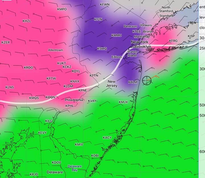
[su_note note_color=”#defcdc”]Sat AM Update: After reviewing last night’s model runs, here are the current trends— For Sunday morning, all models show a period of sleet and freezing rain until about 10 AM Sunday morning, longer duration far northwest. Below, the SREF (Short Range Ensemble Forecast Model) shows sleet/freezing rain in magenta, snow in purple, rain in green.
The rest of Sunday, we’ll have rain, heavy at times.
Still uncertainty about Monday, especially Monday evening. The SREF, NAM and ECMWF (European) have light snow with a coating of accumulation possible, more north of Allentown. The GFS and the CMC (Canadian) have snow showers, very light and scattered, no accumulation in our area. I’ll continue to update again this weekend.
[/su_note]
…from Fri evening—
The latest models have come in. Based on the latest NAM, NBM and WRF, there are some changes in the forecast. The background for the weather this weekend is discussed in previous posts.
Saturday will be dry. Some sun early with high, thin cloudiness increasing throughout the day. Lower level clouds move in later in the afternoon than previously forecast. Very light winds. High 44.
About 3-5 AM Sunday morning, precipitation starts, likely as sleet, freezing rain and wet snow mixed in. After daybreak Sunday, sleet continues and mixes and changes to rain during the morning. Some freezing rain possible north and west early. Driving may be affected early. Tonight’s WRF models have freezing rain/sleet until mid morning.
Rain, heavy at times Sunday. High 45.
A secondary low may linger and intensify off the coast on Monday, with cold air changing precipitation to wet snow on Monday and Monday evening. Still unclear if there will be any accumulation, but a coating to 1 inch possible by Tuesday morning.