STORM UPDATE SUN 11:30 AM

Updated to include snowfall graphic

The latest NAM and GFS models have become available.  Much of  what I wrote earlier this morning still holds. Here are the trends-

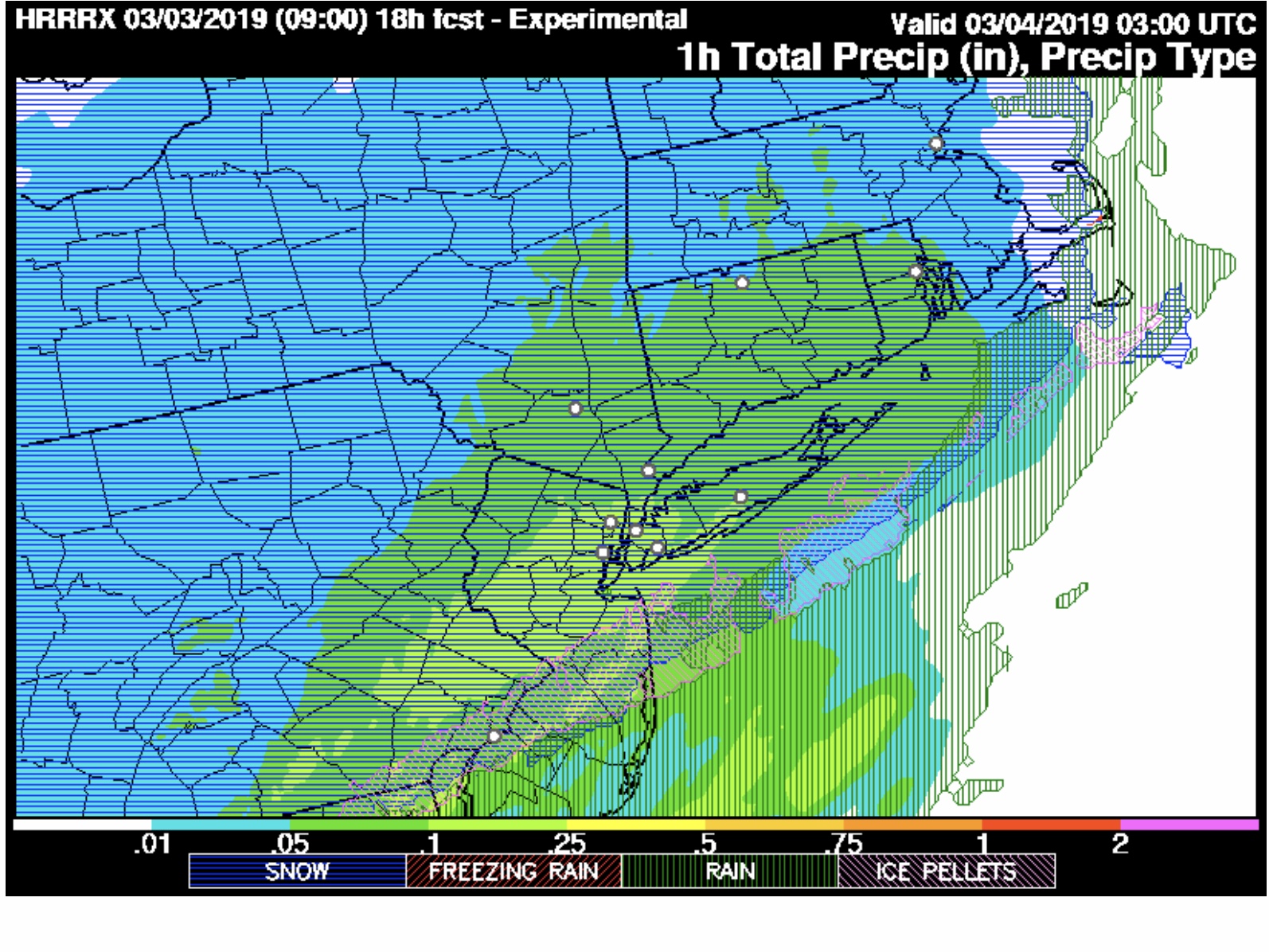
Precipitation starts 2-4 PM, mostly as rain in our area, then mixes with sleet and snow. A mix of sleet, rain and snow falls for much of the storm. Temperatures at the surface are shown as above freezing by most of the statistical models.

QPF values have increased to over 1.10 inches water. (NAM) Temperatures at the surface remain above freezing according to the statistical models. The average temperatures in the lower atmosphere are at or below freezing.

Ordinarily, this would be a slam dunk major snowfall, BUT temperatures in the upper atmosphere become too warm to support snow during the heaviest QPF.

The short range models continue with a mix of sleet, rain and snow.  The changeover to all snow late in the storm occurs after the heaviest has past.

Philadelphia, south NJ (east of the Delaware) will have minimal accumulation. Immediate suburbs north and west about 2-3 inches of heavy mixed snow and sleet, increasing to 7-10 inches in the far north and west. The further north and west, the more accumulation.

Hrrr
Experimental HRRR snowfall totals

This is a tough forecast.  My regular readers of this blog know that predicting accumulation from these storms can sometimes be a choice of upper atmosphere temperatures versus lower temperatures.

Despite the snow-supportive temps in the lower atmosphere, I think the “high 500mb thickness” representative of a warm upper atmosphere will cause more rain and sleet to fall than snow in Philadelphia and immediate suburbs. I went down this wrong path in November. This storm will be a good test of the same forecast issue.

It would be easier to predict a large snowstorm for Philadelphia and the immediate suburbs but I’m not going with that at this time.

STORM UPDATE – 8 AM

A quick update based on current short range (HRRR, RAP, NBM-H ) models.

The short range models are emphatic that the thermal profiles are not supportive of all-snow in much of the immediate Philadelphia area.

Precipitation starts about 4 PM, mostly as rain in our area, then mixes with sleet and snow.  A mix of sleet, rain and snow falls for much of the storm.  Temperatures at the surface are shown as above freezing by most of the statistical models.   QPF values remain in the 0.6- 0.9 inches of water range.

Here’s a depiction of the mix by the experimental HRRR:

10 PM Sunday Precipitation type. HRRRX model

This mix of precip doesn’t lend itself to the usual 2-4 inch description.  My feeling is that the warm thermal profiles aloft will significantly reduce the snow totals in the areas shown in green above.    The mix will change back to all snow before ending about daybreak Monday, but much of the remaining QPF will be low.

I will update with the morning’s models

WINTER WEATHER UPDATE 11:45 PM

As often happens with the afternoon “off-hour” runs of the models, the forecast can be pushed off course.  Such was the case with this afternoon’s NAM. One of these days, I’ll stop looking at them.

Tonight’s latest NAM and GFS models have become available. The trend is towards colder temperatures and higher QPF values.

The NAM has a QPF of 0.89 inches water and the GFS has 0.73.

If this were a straight forward forecast, this would be a 7-10 inch snowfall, even for Philadelphia.  However, there’s a few glitches.

The temperatures at critical levels of the upper atmosphere are a bit warm for snow. We’ve had similar data where we have had snow but other times, there was significant sleet and rain in the mix, making the snowstorm forecast a bust.

Here’s my take. Having seen the new NBM correctly predict precipitation type, I’m leaning on it heavily for this forecast, along with NAM thermal profiles.

A mix of rain sleet and snow will begin about 3-5 PM The mix will continue, leaning towards a shift to more sleet and rain between 7 and and 11pm in the area south of the white line in graphic below.

Transition line snow – sleet rain

Areas northwest of this white line will be all snow. Total snow accumulation In those areas about 5-8 inches by daybreak Monday.

Areas south of this white line will have a considerable amount of sleet and rain in the mix for at least 1/3 of the total storm QPF, during the heaviest precipitation time. This will significantly reduce total snow accumulations. The sleet line moves back south after midnight, as shown in my earlier afternoon post.

It’s an educated guess but the area from the Delaware river north to that white line may have 2-4 heavy inches. I think the warmer temperatures aloft will play a big role in keeping those numbers lower than they would be otherwise as a result of the sleet rain mix.  Very cold temperatures follow later Monday.

I will update again with tomorrow morning’s data.