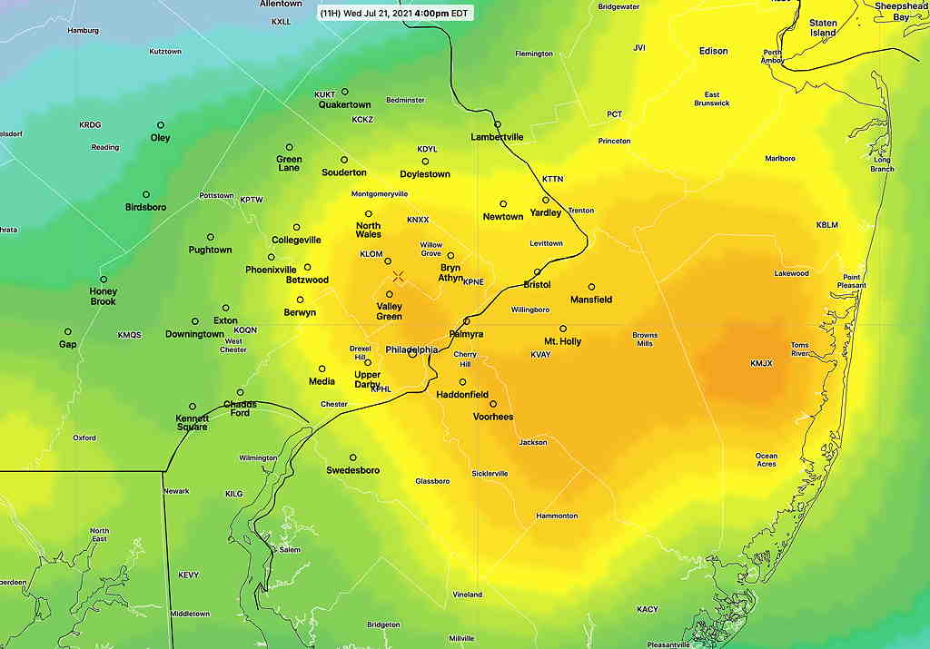
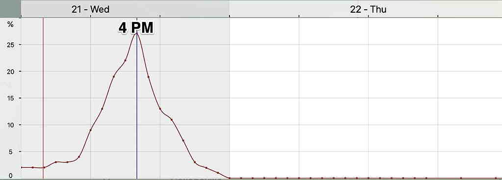
The latest NBM continues to show the highest probability of thunderstorms from Philadelphia eastward at about 4 PM.
NBM Location of highest probability at 4 PM Wednesday. (Click on image for a larger view.)NBM 1 hour Thunderstorm probability for Blue Bell PA
Updated Tues 10:35 PM with HIRESWhighlighted below
A cold front will move through Wednesday afternoon and evening. The actual upper trough is not very sharp and the energy of the front will come through not as a single punch.
Prior to today, the models were showing very little in the way of thunderstorms. Today’s models have changed somewhat with some activity being forecast by most models.
The HREF shows scattered areas of strong vertical motion between 12 PM and 4 PM. Peak time as early as 2 PM Main activity currently appears to be north and east of the city.
HREF Vertical Velocity, jet stream level, at 3 PM Wednesday. The areas with the darkest coloration have the best chance of thunderstorms. (Click on image for a larger view.)NBM Thunderstorm 1 hour probability Blue Bell. Anything more than 18% is a good probability.
Precipitable water (1.4″ to 1.7″) is not as high as recent past thunderstorms and CAPE levels are in the 1100 J/Kg range. Enough for some strong storms but right now, it doesn’t look like a major storm event for most areas.
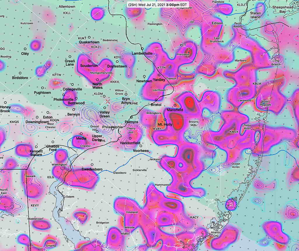
Update Sat 6:55 PM: We had some storms during the afternoon, mostly in western suburbs and Bucks county. This afternoon’s models (18z) are still advertising strong dynamics in Philadelphia as the main batch of storms develops and moves through between 7 and 11 PM
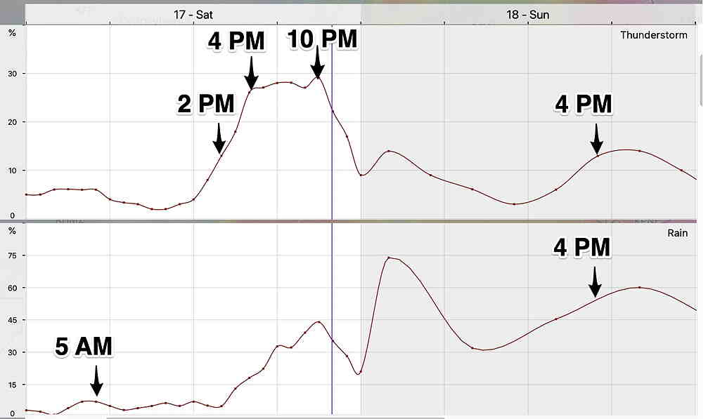
Updated Fri 6:30 PM with latest GFS timing highlighted below Updated Fri 7:15 PM with latest RAP timing highlighted below Updated Sat 7:15 AM with latest NBM meteogram highlighted below
Low pressure near the Great Lakes will send mid-level and upper air disturbances into our area Saturday and Sunday causing periods thunderstorms and plain rain.
So what is the most likely timing of the thunderstorms and rain on Saturday and Sunday?
Based on the latest GFS and HRRR models, some light shower activity is possible around daybreak Saturday morning. Expect considerable sunshine with some building cumulus clouds for most of the day.
The HRRR shows some widely scattered thunderstorm activity possible as early as 1-2 PM.
Most models are on board with very heavy thunderstorms late afternoon and evening. Peak time 4-8 PM. Earlier in western suburbs, a later in NJ. This will be a wide line of thunderstorms that will move from west to east. Friday afternoon’s GFS shows thunderstorms beginning 7- 8 PM Saturday evening.
This afternoon’s RAP maintains the possibility of earlier storms, in line with the meteogram graphicof the NBM below.
Be advised that the upper air dynamics for these storms is considerable and impressive. Severe weather and heavy rain likely. CAPE values >3000 J/kg and Lifted Index less than -8. Precipitable water is about 2″. Friday afternoon’s RAP shows CAPE values as high as 4000 J/Kg!
High temperatures 93.8º ± 1.6º (NBM Blue Bell)
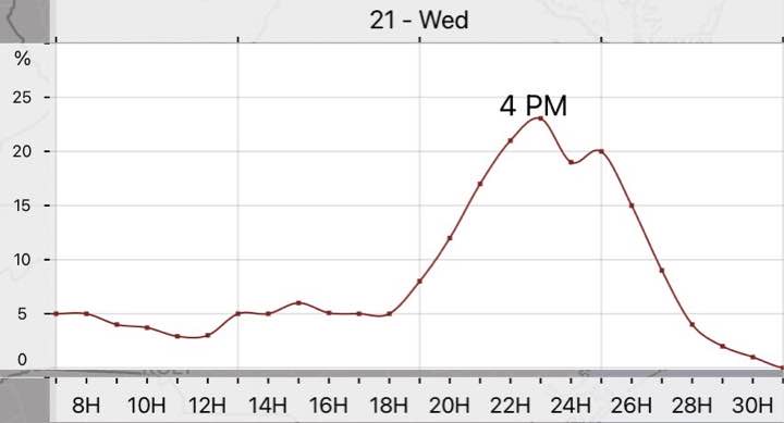
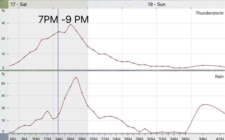
The trigger for these heavy thunderstorms will be a very intense upper air disturbance. The timing is best captured by a meteogram, showing probability of thunderstorms—
Updated NBM meteogram showing highest possibility 7-9 PM, but has increased the possibility of storms earlier in the afternoon. NBM meteogram for Blue Bell PA showing probability of rain and thunderstorms (Thunderstorms are convective-type precipitation that are categorized separately by many models.) Note that 30% probability for thunderstorms is actually considered high, since this is a 1 hour probability.) (Click on image for a larger view.)
The procession of disturbances across our area will continue.
Following some early morning showers, considerable low cloudiness. Some sun will likely break out at times but any sun will heat things up to get some thunderstorms going.
Friday afternoon’s GFS shows very little rain on Sunday. The RAP shows afternoon thunderstorms, similar to the NBM forecast.
Updated Saturday 7:30 PM: The latest models have a party to mostly sunny Sunday. A slight chance of an afternoon scattered thundershower northern suburbs.
Most of the precipitation will be scattered rain showers. The model blend (NBM) paints a very cloudy and rainy day picture, but I think it’s likely we’ll get some sun at times, based on the NAM and HREF. High temp 83.7º ± 2.7º (NBM Blue Bell.)
Update Thu 6:09 PM : Tonight and Friday should be a very low thunderstorm probability timeframe. The later part of Saturday and Sunday look to be active weather days.
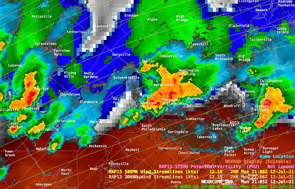
Thu 06:05 PM Forecast Review —Some thunderstorms did develop around the region Wednesday evening, but not where the models had forecast; instead of south and west of the city, they were mostly north and east.
Updated Wed 10:19 AM : As mentioned yesterday, the models didn’t do too well with thunderstorm prediction on Monday and Tuesday.
For today, Wednesday, things are a little different. An upper air trough (see graphic below) moves through about midnight and this upper air support along with several areas of vorticity ahead of it are expected to trigger thunderstorms in advance between 4 PM and 11 PM tonight. Currently, the models have the heaviest activity to our west and south, but show scattered activity elsewhere as well. Precipitable water about 1.8″, CAPE = 1800, Lifted Index= -6
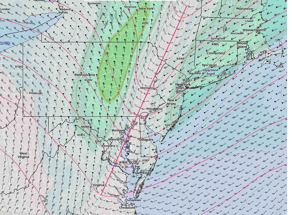
RAP model upper air trough prediction for midnight tonight. (Click on image for a larger view.)
Updated Tues 7:30 PM: I’m glad I’ve been taking a break from posting any mid-week weather forecasts over the past two days; most if not all of the models have been wrong about the high temperatures and the thunderstorm development today, Tuesday.
An unexpected change in the position of a frontal boundary gave us an easterly stable wind flow, lower temperatures, and as of this post, no thunderstorms.
The boundary is south, across Delaware, and it’s unclear when it moves north past us, whether we’ll have and thunderstorms later this evening or on Wednesday. The numerical weather models so often impress me. Not today.
It shouldn’t be any news to anyone that we’re entrenched in a hot and very humid air mass.
High instability (Lifted Index = -6 and lower) and high CAPE (>3000 J/kg) along with some upper air disturbances have set off thunderstorms. Precipitable Water values are more than 2.2 inches.
While my immediate neck of the woods hasn’t seen more than a few drops of rain, areas just a mile or so down the road have had severe thunderstorms with very heavy rain.
Current Radar with super-imposed Water Vapor image and RAP model upper air flow at 5 PM. (Click on image for a larger view.)
Thunderstorms are expected to continue in some areas past midnight.