
Updated Sunday forecast Sat, 7:30 PM highlighted below.
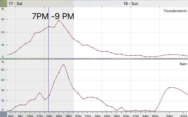
Update Sat 6:55 PM: We had some storms during the afternoon, mostly in western suburbs and Bucks county. This afternoon’s models (18z) are still advertising strong dynamics in Philadelphia as the main batch of storms develops and moves through between 7 and 11 PM
Updated Fri 6:30 PM with latest GFS timing highlighted below
Updated Fri 7:15 PM with latest RAP timing highlighted below
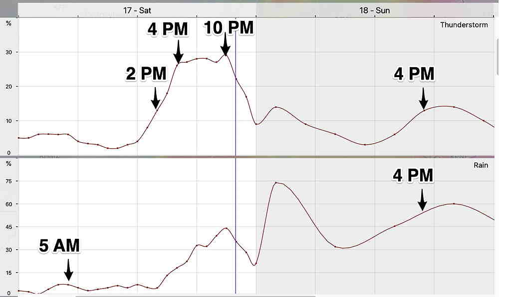
Updated Sat 7:15 AM with latest NBM meteogram highlighted below
Low pressure near the Great Lakes will send mid-level and upper air disturbances into our area Saturday and Sunday causing periods thunderstorms and plain rain.
So what is the most likely timing of the thunderstorms and rain on Saturday and Sunday?
Based on the latest GFS and HRRR models, some light shower activity is possible around daybreak Saturday morning. Expect considerable sunshine with some building cumulus clouds for most of the day.
The HRRR shows some widely scattered thunderstorm activity possible as early as 1-2 PM.
Most models are on board with very heavy thunderstorms late afternoon and evening. Peak time 4-8 PM. Earlier in western suburbs, a later in NJ. This will be a wide line of thunderstorms that will move from west to east. Friday afternoon’s GFS shows thunderstorms beginning 7- 8 PM Saturday evening.
This afternoon’s RAP maintains the possibility of earlier storms, in line with the meteogram graphic of the NBM below.
Be advised that the upper air dynamics for these storms is considerable and impressive. Severe weather and heavy rain likely. CAPE values >3000 J/kg and Lifted Index less than -8. Precipitable water is about 2″. Friday afternoon’s RAP shows CAPE values as high as 4000 J/Kg!
High temperatures 93.8º ± 1.6º (NBM Blue Bell)
The trigger for these heavy thunderstorms will be a very intense upper air disturbance. The timing is best captured by a meteogram, showing probability of thunderstorms—
Updated Meteogram
The procession of disturbances across our area will continue.
Following some early morning showers, considerable low cloudiness. Some sun will likely break out at times but any sun will heat things up to get some thunderstorms going.
Friday afternoon’s GFS shows very little rain on Sunday. The RAP shows afternoon thunderstorms, similar to the NBM forecast.
Updated Saturday 7:30 PM: The latest models have a party to mostly sunny Sunday. A slight chance of an afternoon scattered thundershower northern suburbs.
Most of the precipitation will be scattered rain showers. The model blend (NBM) paints a very cloudy and rainy day picture, but I think it’s likely we’ll get some sun at times, based on the NAM and HREF. High temp 83.7º ± 2.7º (NBM Blue Bell.)
Look for updates over the weekend.