WEEKEND WEATHER FORECAST

Updated Sunday forecast on Sat @ 6:30 PM highlighted below

Overview: The good weather blocking maintains itself for most of the weekend. Moisture aloft in the form of some high, thin cloudiness both Saturday and Sunday. An overall beautiful weekend, weather-wise.

The blocking pattern that has been providing the extended period of fair weather will be breaking down and a return flow around departing high pressure will bring in moisture initially in the form of high clouds. Showers approach late Sunday evening.

GFS Forecast for Saturday 12 PM. High (cirrus) cloudiness (brown) moves in with moisture aloft (white arrows). (Click on image for a larger view.)

Saturday

Sunny in the morning. Mild. Moisture aloft will move in to our area, with sunshine through high cloudiness Saturday afternoon. High temperature 76.4º ± 2.1º (NBM Model Blue Bell) Light winds.

Seasonal average high temperature this time of year is 69º (Blue Bell) and 71º (Philadelphia)

Sunday

High pressure continues to move off to our east as more moisture moves in aloft. Warmer air moves in.

While Saturday’s forecast overstated the high thin cloudiness based on the GFS, most models have increasing cloudiness on Sunday per the paragraph below.

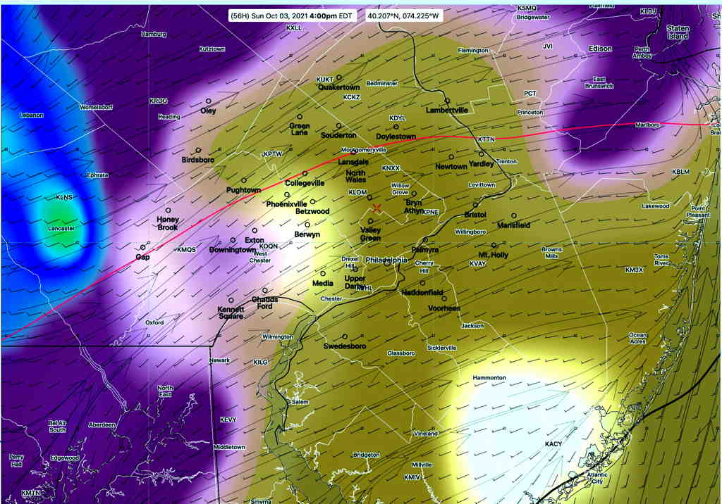
The models are forecasting a varying degrees of cloudiness, but the current trend is for some early morning cloudiness, then sunshine, then increasing cloudiness after 3-6 PM, especially western suburbs.

There is some degree of uncertainty regarding the amount of cloudiness on Sunday. This afternoon’s NAM and NAM-NEST bring in some showers late afternoon and early evening. Likely too fast.

High temperature 80.4º ± 1.8º (NBM Model, Blue Bell) Light winds.

GFS forecast 4 PM Sunday. (brown/tan = high thin clouds) (Purple = middle to low clouds) Some precipitation to the west (green/ blue) (Click on image for a larger view.)

WEEKEND OUTLOOK AND BEYOND

Update Thu 9:30 PM — Today’s ensemble models (GEFS, SREF) (statistical models) suggest that some cloudiness moves in Sunday afternoon and possibly some showers late Sunday afternoon or early evening Sunday. So the blocked good weather pattern may be breaking down somewhat sooner.


Original post
The current “omega” blocked weather pattern, as described in my post from earlier this week, will briefly open up over the weekend. Luckily, we will still be on the favorable weather side of this blocked pattern for Saturday and most of Sunday.

Here’s the current middle/upper air pattern for today, Thursday, with the closed low over Maine—

GFS 500 mb winds today, Thursday. We’re on the northwesterly wind flow side of the low. (Click on image for a larger view.)

The mid level/ upper closed low in Maine will move northeastward and moisture in the center of the country will approach late Sunday with an increase in cloudiness.

The upper air pattern will briefly unblock over the weekend.

Unfortunately, another closed low is expected to develop over the mid-section of the country, near Missouri on Monday.

While we’ve been on the “good weather side” of the upper low this past week and will be for the upcoming weekend, the location of the new closed upper low over Missouri will place our area on the northeastern side of the closed low with moisture streaming up from the south. Expect clouds and showers for several days next week, starting Sunday night or Monday.

GFS 500 mb wind forecast 2 AM Tuesday showing closed mid-level and upper low over Missouri. A southwesterly flow of moisture will bring clouds and showers to our area much of early next week. (Click on image for a larger view.)

Weather… and Other Things 'Up in the Air'