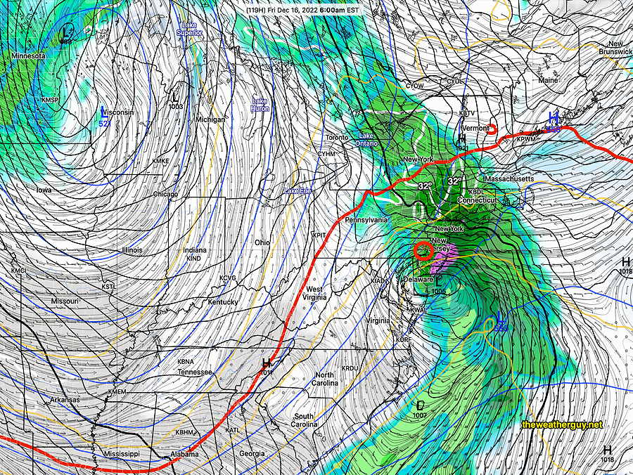
Update Fri 12/30 @ 9:36 AM — A quick update to the weekend outlook posted last night (below), based on the latest models.
Saturday will be quite cloudy. Some fog possible in the morning with low clouds throughout the day.
Some light showers are possible late morning and around noon especially just over the river in NJ. The bulk of the rain will be moving in between 2 and 5 PM around the city. Rain tapers off after midnight. Bulk of the rain is moving to our southeast and total rainfall will be less than 0.4 inches in or area.
NBM is showing a slight decrease in mean high temperature on Saturday to about 53º but it has increased its spread to 3.5º (So think of it as 53º ± 3.5º, a wider than usual range of uncertainty.)
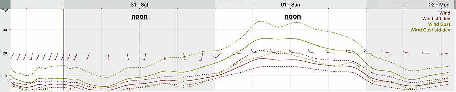
For Sunday, New Year’s Day, skies clear during the morning hours. Winds and wind gusts still robust, but maxing out about 27-30 mph instead of the 35 mph gusts posted yesterday. NBM mean high temperature of 53º again with an even larger range of uncertainty, ± 4.0º.
I’ll update the forecast later today.
Previously Posted Thu 7:49 PM —
If you’re planning on outdoor activities, Friday will likely be the best day weather-wise of the coming three.
Friday
Sunshine with milder temperatures for Friday, with a high of 54º-55º. Thickening high level cirrus clouds expected mid to late afternoon.
NBM model forecast high temperatures for Friday. Black contours are 2º increments (Click on image for a larger view.)
Saturday and Sunday Outlook
Saturday will be cloudy. Scattered light sprinkles as early as noontime, but steadier rain moves in between 2 and 4 PM. It will be mild. Latest models have backed off on forecasting the heavy rain; light to moderate rain expected around midnight.
Sunday will continue mild and the sun should break out as skies clear. A big consideration will be the wind, with wind gusts around 30-35 mph, tapering later in the afternoon.
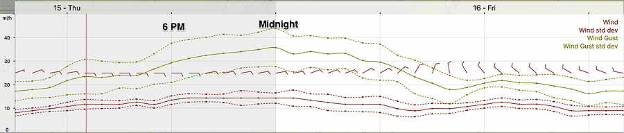
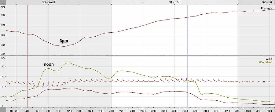
Thursday’s 19z NBM model wind meteogram for Blue Bell PA (Click on image for a larger view.)
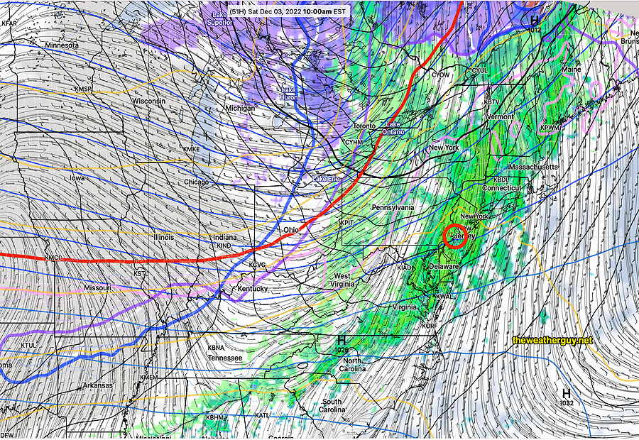
It’s still raining in many places at 10 AM and the rain is expected to end around noon. Cloudiness should diminish from south to north about 2-4 PM.
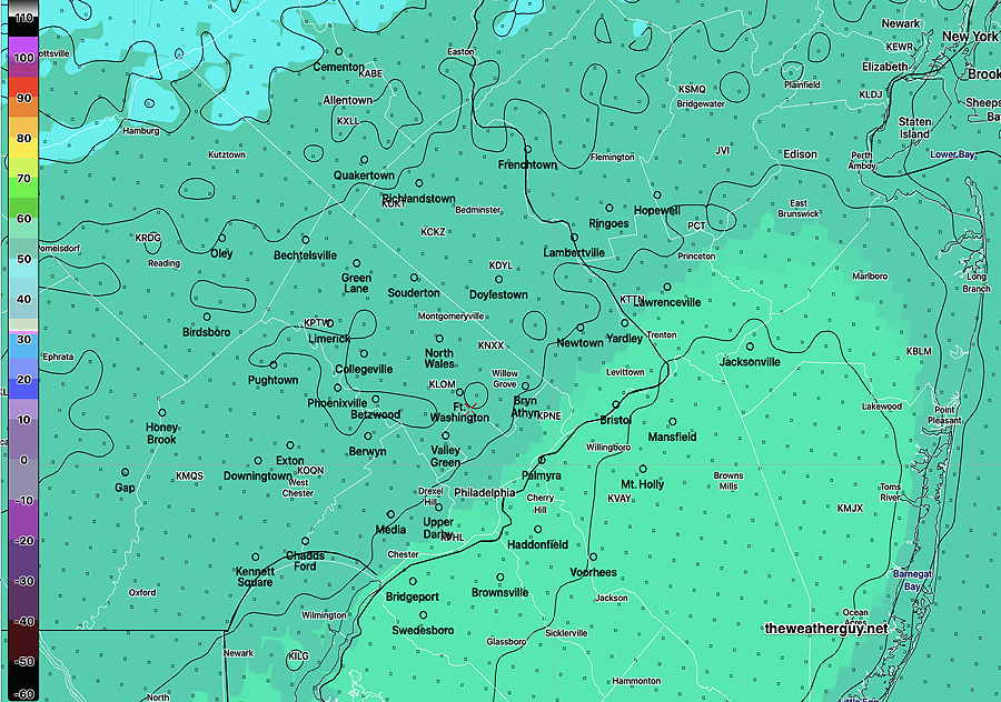
How much rain did we get?
MRMS rainfall estimates through 9 AM Friday. (add another 0.10 inches through noontime) The numbered contours are in mm. 25.4 mm =1 inch. (Click on image for a larger view.)
Thursday Weather Update
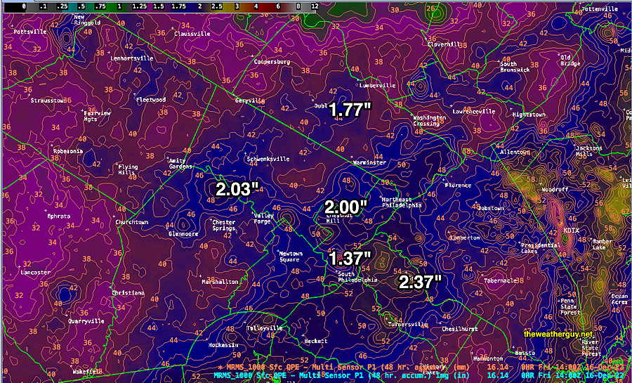
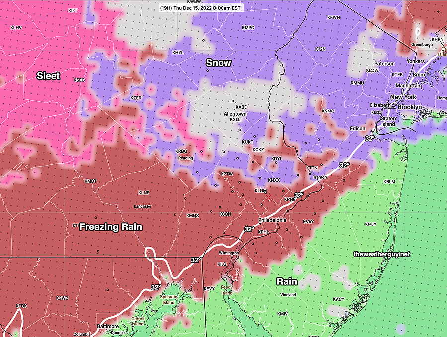
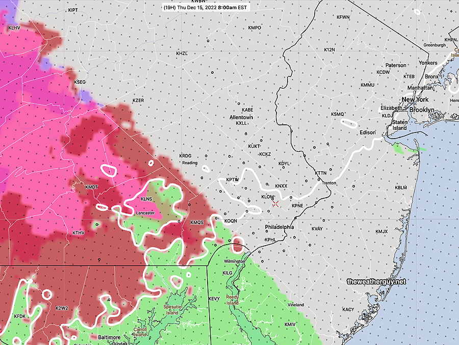
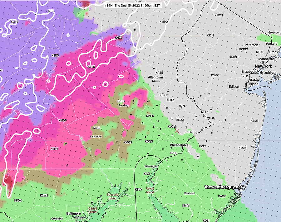
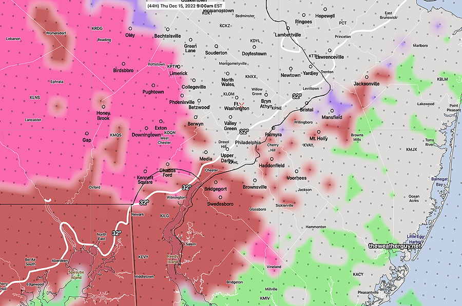
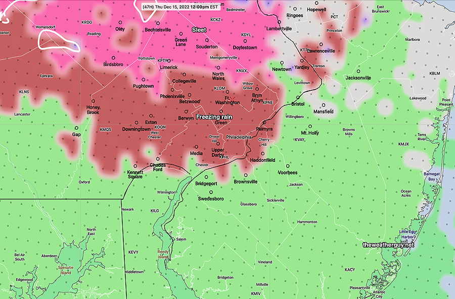
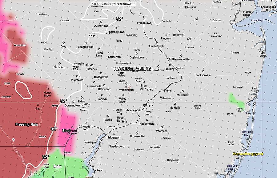
Update Thu 12/15 @ 1:08 PM — A changeover to all rain in the Philadelphia area. Heaviest rain between 6 PM and 11 PM. Total rainfall about 1.2″ to 1.7″
Highest wind gusts this evening towards midnight—
NBM wind meteogram for Blue Bell, PA . Highest wind gusts around midnight. (Click on image for a larger view.)
Following this storm, we’ll be going into a generally colder pattern for the week before Christmas. A snow storm is currently being forecast by the GFS, GEFS and ECMWF for Friday Dec 23rd. I’ll keep tabs on it.
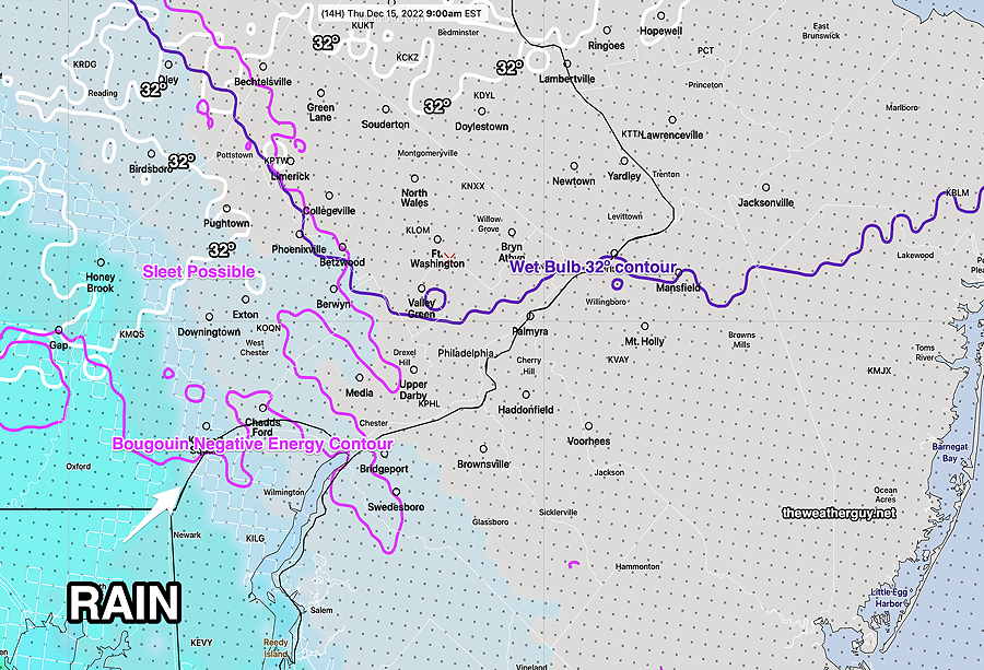
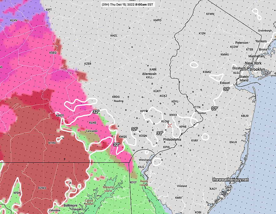
We’re getting more sleet than I had forecast; (“perhaps some sleet mixed with rain initially”) the delay of the precip as forecast by last night’s HRRR and NBM was wrong.
Temperatures in my neck of the woods are already above freezing (33º-34º) but a thin layer of colder air at about 2000-3000 feet is giving us the sleet. This layer may persist a bit longer as some dynamic cooling occurs, but a changeover to rain should occur about 9 AM.
With the sleet coming down, this morning’s HREF is showing it should be freezing rain rather than sleet, clearly not correct either.
Little Wintry Mix in Philadelphia & near Suburbs
Update Wed 12/14 @ 8:50 PM — A further review of the latest Canadian HRDPS and German ICON models as well as this afternoon’s ECMWF show a delayed onset of the precip here allowing temperatures to rise at critical levels of the atmosphere.
These models are in support of the preferred HRRR forecast—Little in the way of wintry mix (perhaps some sleet mixed with rain initially) except in areas of western Chester County and north into Lehigh County which may have more sleet/freezing rain before change to rain.
The models show very light precip moving in between 8 and 10 AM, with temps above freezing at critical vertical levels.
Tonight’s 00z NBM model captures this well at 9 AM; most of the precip is still south of the city with temps too warm for wintry precip here—
Tonight’s 00z NBM shows critical temperatures north of the precipitation at 9 AM. The precip has barely entered Philadelphia. Bourgouin negative energy contour is a measure of the likelihood of sleet. West and north of this contour are the areas which most likely to have sleet. It all changes rapidly to rain by late morning. Notice how far north the 32º line (white) is. (Click on image for a larger view.)
Update Wed 12/14 @ 5:52 PM — This afternoon’s models are consistent with my previous update; with the exception of the HRRR and Canadian HRDPS, they show an area of sleet and freezing rain moving in about 7-8 AM.
As mentioned, over past winters, the HREF and NAM-NEST and HIRESW comprising the HREF have over-forecast freezing rain/sleet.
Here’s the current HREF Precipitation type (PTYPE) at 8 AM Thursday—
Today’s 18z HREF model PTYPE at 8 AM Thursday I believe the HREF is over-doing the freezing conditions . (Click on image for a larger view.)
Despite several models leaning towards the above, my preferred forecast model here is the HRRR shown below.
Here’s the HRRR forecast at 8 AM with the precipitation delayed to our south and the 32º line is already moving past Philadelphia—
18z HRRR forecast for 8 AM Thursday. White line is 32º surface temp dividing line. Precip is still south of our area. (Click on image for a larger view.)
As I forecast this morning, the HRRR has consistently been forecasting a slower onset of the precipitation, allowing the temperatures to rise before the onset. The HRRR is somewhat similar with the Canadian HRDPS, so I’m leaning towards a less wintry commute tomorrow morning
Here’s the HRRR forecast for 9 AM. Even less of a threat, with the precip still to our south—
18z HRRR forecast for 9 AM (Click on image for a larger view.)
Remember that the NWS and TV weather people need to concern themselves with safety concerns and liability, so they are always going to err on the side of a more safety-aware and cautious forecast. I’m just trying to give you my best insight.
I’ll do a quick update with tonight’s HRRR and the HRDPS about 9 PM tonight.
It looks like this forecast below from Wednesday morning might not have posted.
Update Wed 12/14 @ 7:45 AM — No significant change in the models, but review of last night’s 00z and 06z model runs suggests that the HREF model graphics posted last night may be over-estimating the freezing rain and timing of the precipitation.
While the HREF hasn’t changed, the HRRR has consistently been forecasting a slower onset of the precipitation, allowing the temperatures to rise before the onset. The HRRR is somewhat similar with the Canadian HRDPS, so I’m leaning towards a less wintry commute tomorrow morning. I’m basing this on recent winters where freezing rain was over-predicted by the current models.
My forecast is for light sleet and some freezing rain about 8-9 AM, changing to sleet and rain and finally all rain in the immediate PHL area by 11. The forecast assumes that the precip will be delayed to our southwest.
The HRRR 8 AM captures my current forecast—
HRRR forecast for 8 AM. Precip hasn’t reached PHL White line is 32º line (Click on image for a larger view.)
By 11 AM we have mostly rain —
HRRR forecast precipitation type by 11 AM. Notice the delayed/blocked preciip. (Click on image for a larger view.)
I’ll update later today.
Update Tue 12/13 @ 8:49 PM —
I’ve been reviewing today’s models and as usual, there are differences in their forecasts.
Here’s where they agree: Precipitation overspreads the area between 7 and 9 AM from the southwest. All change the precipitation to heavy rain, lingering into Friday morning. However the changeover to all rain may be gradual instead of rapid in northwestern areas. Winds gusting over 40 mph and rainfall amounts over 1 inch expected. Heaviest rain likely around midnight. Some rain lingering into Friday.
Here’s where there are differences: The temperature profiles of the models all vary quite a bit. On the warmer side is the GFS and ECMWF which has a changeover to all rain in the immediate area by 10 AM. The GFS has sleet and some snow in areas, along with freezing rain before a rapid changeover.
The higher resolution models, our NAM-NEST, the Canadian HRDPS, along with the HRRR (and throw in the German ICON) are somewhat colder with more areas of sleet lingering into late morning.
The HREF (ensemble model) probably captures things the best and is similar to the Canadian HRDPS (but colder than the GFS). Here’s its 9AM forecast —
Today’s 18z HREF model forecast for 9 AM Thursday shows light spotty precip northwest of the city, mostly sleet (pink) freezing rain (brick red). According to the HREF, the surface freezing line (32º) is just cutting through Philadelphia at 9 AM. (Click on image for a larger view.)
By noon, the HREF still shows considerable sleet and freezing rain. I think this is overdone and it will be mostly rain in the immediate area—
HREF forecast for noon Thursday is probably over-doing the frozen precip in the immediate Philadelphia area. I think it will be mostly rain here by noon if not earlier. (Click on image for a larger view.)
To further complicate things, the latest ECMWF and NBM became available while writing this update. It has an influx of cold air in the afternoon, suggesting there might be a mixed precip during the day in northwestern suburbs.
A very dynamic storm and I think we’ll have to wait until Wednesday night to nail it down.
Update Tue 12/13 @ 11:17 AM — Many of this morning’s models continue to show light precipitation moving in between 7 and 8 AM Thursday morning before temperatures rise above freezing.
NBM and the GFS have very light snow falling early (7 AM) with a changeover to sleet/freezing rain from 8 to 10 AM. The Canadian RGEM, SREF show no snow, but rather sleet and freezing rain between 8 and 10 AM.
The Thursday forecast period has now fallen within the range of some of the higher resolution models (60 hours) (NAM-NEST and HIREF-FV3). These models show the precip moving in later, after temperatures have risen. They have very little precipitation falling until the temperatures rise above 32º at 10 AM.
Tuesday’s 12z HIRESW-FV3 model showing precip hasn’t moved in at 9 AM. Temperatures above 32º in the immediate area. (Click on image for a larger view.)
So there’s still uncertainty about a possible bad commute to work or no real problem. Most of the high resolution models’ forecasts extend only to 48 hours and tonight’s model runs will begin to cover the time period in question. Stay tuned.
Update Mon 12/12 @ 8:21 PM — Additional review of the NBM and ICON models suggests a mix of snow/sleet/rain is possible even up until noon in some areas. (There’s more uncertainty than previously predicted, as the precip is now forecast to be moving in before the cold air leaves.)
Complicating this forecast is an 540 thickness line well north of our region, indicating temperatures higher up are too warm for snow, yet the current NBM shows a high probability of snow in some areas during the mid morning hours.
Eventually, it’s all expected to turn to rain. The question for our western and northwestern suburbs, will it be at 9 AM or 2 PM? Here’s the latest NBM conditional probability of snow —
NBM conditional probability of snow at 10 AM Thursday. (Conditional probability means if there is precipitation, will it be snow?) (Click on image for a larger view.)
Update Mon 12/12 @ 6:01 PM — Today’s models continue with a rain event for the storm expected to move in Thursday through part of Friday. However, the Canadian GEM (and now the GFS) continues to have the rain move in when the lower levels of the atmosphere will be cold—
Monday’s 18z Canadian RGEM (RDPS) model forecasts some sleet and even some freezing rain at the start (8-9AM just west and northwest of the city. A changeover to ALL RAIN is expected shortly afterwards. (Click on image for a larger view.)
The Canadian GEM model was updated last winter and it did very good with the few mixed precipitation events we had. So we’ll see if its forecast holds.
The latest GFS now has a similar forecast for 9 AM Thursday—
Monday’s 18z GFS forecast Precipitation Type for 9 AM Thursday morning. White line is 32º surface temp line. (Click on image for a larger view.)
Update Mon 12/12 9:08 AM — Considerable instability cloudiness today (Monday) with a chance of a widely scattered snow flurry in the early afternoon.
As for the storm expected Thursday through Friday, no significant change in the forecast. An all-rain event, however, the Canadian RGEM and the German ICON models have the rain moving in just before the cold air exits. There’s the possibility of some light freezing rain very early Thursday morning before a changeover to all rain.
Update Sun 12/11 9:16 PM — Considerable instability cloudiness tomorrow (Monday) with a chance of a widely scattered snow flurry in the early afternoon.
Update Sun 12/11 6:26 PM — No change with today’s models. All have it too warm for snow here Thursday through Friday. (The German ICON model has it possibly starting as light snow early Thursday morning, but quickly changing to all rain.) Heavy rain, high winds still expected.
The long range forecast for the period following this storm is for colder than seasonal averages for the following week. Jet stream pattern still suppots my 2023 Winter Season Snow Outlook.
Previously Posted Sun 12:09 PM —
Storm to affect us late Thursday through Friday
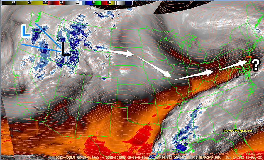
A strong upper air low and surface low are in Washington State today, Sunday.
Here’s current satellite water vapor image capturing the mid to upper atmosphere and showing upper air low L and surface level L—
Current Water Vapor image at about 10AM today, Sunday. Upper air low (BLUE L) with surface level low (BLACK L) Orange streamlines show RAP model jet stream flow (300 mb winds) superimposed on the current satellite image. Current general path of low (white arrows) (Click on image for a larger view.)
The low is expected to move over the Great Lakes and most models have it transferring its energy to a developing coastal low by late Thursday into Friday.
Here’s the very latest GFS model showing the coastal low—
Today’s 12z GFS model just available. Secondary low forms and affects us with heavy rain and wind early Friday morning. Two things to note: The red 540 thickness line is well north and west of us, indicating much of the atmosphere is too warm for snow here. Also note the the main low remains over Wisconsin, possibly affecting us further.
Two things to note: The red 540 thickness line is well north and west of us, indicating much of the atmosphere is too warm for snow here. Also note the the main low remains over Wisconsin, possibly affecting us later in the weekend.
A very complex and dynamic situation, but at least for the first round, we’ll have heavy rain and windy conditions in our area from this system late Thursday through Friday.
Indeed, the models show the possibility of another disturbance developing along the stalled boundary to our south and affecting us Sunday to Monday.
The forecast has already changed over the past few days. Other changes are likely. Stay tuned.
Update Fri 12/02 @ 8:24 AM — The latest NAEFS continues to show a warm front type snow situation, now for early NEXT Friday morning. Still a long ways off in the future, but it is potentially our first wintry possibility for this season.
This morning’s NAEFS forecast for NEXT Friday morning—
Today’s NAEFS forecast for next Friday 4 AM. Critical temperature 32º lines (blue, magenta) and surface 32º line (white). Red is 540 thickness line. This forecast suggests some snow will fall above the red thickness line, but too warm for any accumulation right around the city. (Click on image for a larger view.)
Update Thu 12/01 @ 8:10 PM — I’ve had my eye on the long-range forecasts. Over the past week, there has been a consistent signal for a warm-front type winter mix for NEXT Friday evening (12/9). I get a kick out of trying to spot these events. (Usually these extended range forecasts fall apart with time. )
Here’s the possibility as shown in the NAEFS—
Friday Dec 9th forecast— near freezing temperatures with warm front type snow possible west of the city, possibly also affecting our immediate area. White wavy line is 32º line. Red line is 540 thickness line. Way too early to really take this forecast literally, but the NAEFS has been showing this possibility for the past week. (Click on image for a larger view.)
Sunday now looking sunny
Update Thu 12/01 @ 8:02 PM — This afternoon’s models have backed away from the instability cloudiness previously forecast for Sunday. Sunday now looks to be mostly sunny but cold.
Weekend Weather Outlook
Update Thu 12/01 @ 11:41 AM — A strong cold front moved through as forecast yesterday. Another very strong cold front, associated with deep low pressure in Canada, will move through Saturday morning with additional rain and strong winds.
Saturday morning—
Thu 12z NAM forecast for 10 AM Saturday showing cold front, rain/snow. High winds expected again with this frontal passage. There may be clearing by afternoon. (Click on image for a larger view.)
Most models have the rain ending by 12PM -1 PM Saturday with gusty winds continuing into the afternoon and some clearing and sun possible by 3 PM. This morning’s GFS shows a secondary cold front moving through about 5 PM Saturday with a few sprinkles.
Sunday looks to have considerable instability cloudiness and windy conditions.
Another front expected Tuesday and the general trend is for cold weather the end of next week.
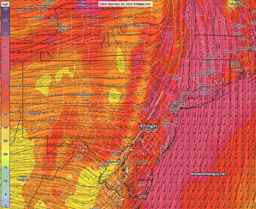
Update Wed 11/30 @ 8:04 AM — Last night’s models show little change in the forecast. The cold front comes through about 3 PM with strong wind gusts starting around noontime. Rain this morning precedes the frontal passage.
Latest RAP model (09z) meteogram for location Blue Bell, PA shows barometric change at 3 PM, indicating frontal passage. Wind gust near 45 mph at Blue Bell. Some higher gusts predicted in western suburbs. (Click on image for a larger view.)
With Twitter’s change in ownership, I am suspending auto-posting to the Twitter site and will continue to evaluate the situation. Those of you using Twitter can learn of theweatherguy.net updates by following me on Mastodon. ( Read more here. )
Wednesday Forecast Update
Update Tue 11/29 @ 5:41 PM — We’re back to a frontal passage between 2 and 4 PM with rainfall about 0.5 inches. Rain starts in the morning Wednesday, about 8-9 AM.
Winds increase early afternoon with many models exceeding 40 mph wind gusts and with some approaching 50 mph.
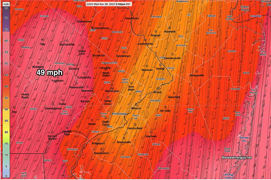
Here’s the latest GFS (18z) wind gust forecast for 3 PM Wednesday—
18z GFS wind gusts and wind direction at 3 PM Wednesday. (color coding is wind gust speed) Notice the change in streamline direction (white dashed line) that occurs at 3 PM, indicating the winds are shifting from the SW to the WNW with the frontal passage. (Click on image for a larger view.)
Here’s the latest RAP model (21z) wind gust forecast for 3 PM—
21z RAP model Wind gust forecast for 3 PM Wednesday (Click on image for a larger view.)
Update Tue 11/29 12:22 PM — The latest models show the front moving through here somewhat earlier on Wednesday than previously forecast. Current timing for the frontal passage about 12-2 PM with the highest wind gusts (40-50 mph) around that time. Total precipitation in our immediate area is now forecast to be only about 0.40-0.50 inches.
Update Mon 11/28 @ 8:22 PM — Heavy rain and high winds Wednesday afternoon between 2 and 6 PM. The strong cold front mentioned in the “week overview” below looks like it might pack a punch as it moves through between 2 and 6 PM (peak probability 3-5 PM).
Rainfall 1.0 inches (CMC-GEM) to 1.4 inches (NBM) are possible in a few hour period. Wind gusts 40-50 mph possible.
Previously Posted Mon 5:52 PM —
Week Overview
Two weather events for this coming week, currently timed for Wednesday and Saturday. There’s good agreement in the models for Wednesday’s rain. There’s less agreement in the timing for Saturday’s rain.
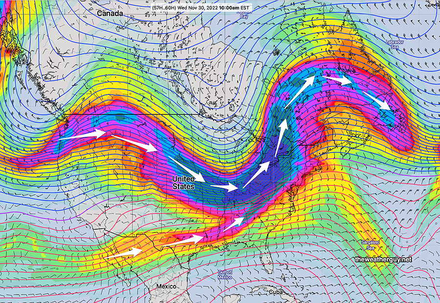
The jet stream will be making some significant changes over the week as cold high pressure pushes the jet flow down into our area on Wednesday with milder temperatures becoming colder by Thursday as a strong cold front moves through—
NAEFS forecast (250 mb winds) for Wednesday 10 AM shows a dip in the jet flow in response to cold air moving down from Canada. (Click on image for a larger view.)NAEFS forecast for Wednesday shows a cold front in western PA and rain in our area. (red line is the 540 thickness line ) (Click on image for a larger view.)
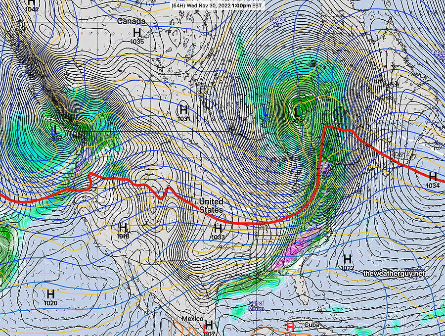
Here’s what the surface map is forecast to be Wednesday at 1 PM with the cold front approaching the Delaware Valley—
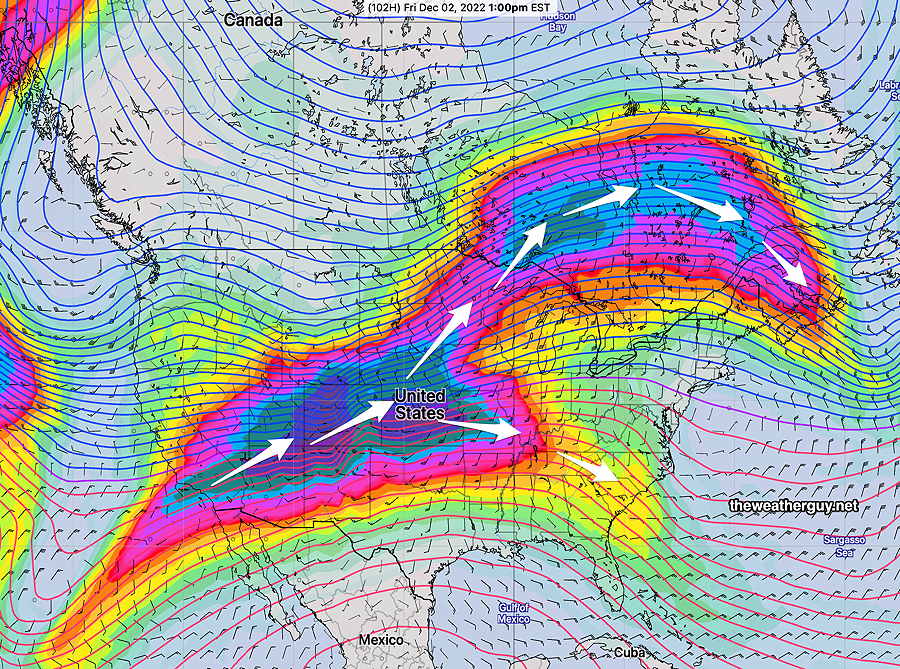
High pressure builds in for Thursday and Friday. Another dip in the jet flow will bring another cold front through on Saturday—
Split Jet flow on Friday 1 PM with a ridge trying to develop, but the split southern stream jet flow will bring rain by Saturday.
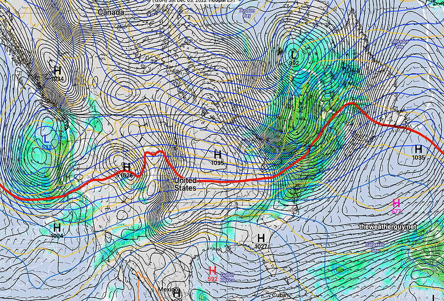
Surface forecast for Saturday—
NAEFS forecast for Saturday. Another cold front moves through. (red line is the 540 thickness line )