Any snow on the horizon for us?
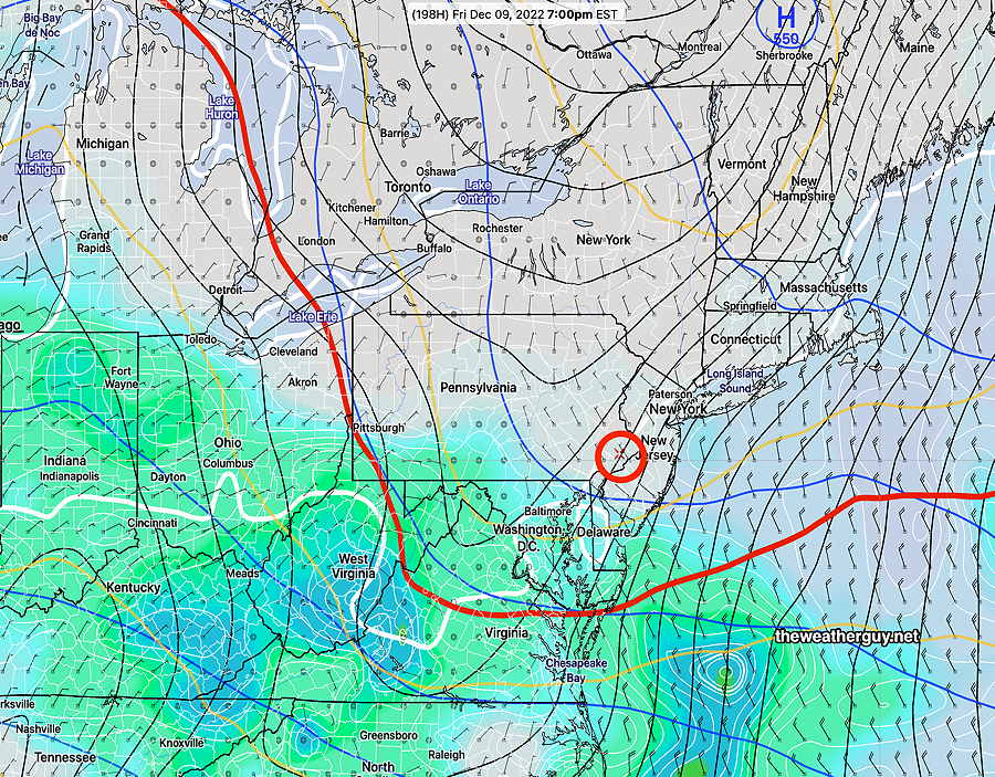
Update Fri 12/02 @ 8:24 AM — The latest NAEFS continues to show a warm front type snow situation, now for early NEXT Friday morning. Still a long ways off in the future, but it is potentially our first wintry possibility for this season.
This morning’s NAEFS forecast for NEXT Friday morning—
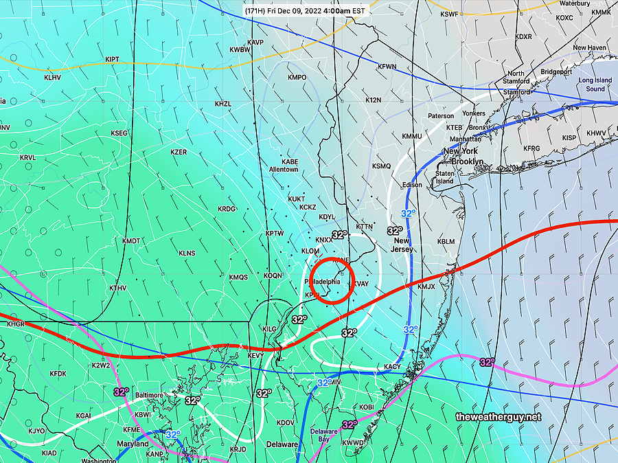
Update Thu 12/01 @ 8:10 PM — I’ve had my eye on the long-range forecasts. Over the past week, there has been a consistent signal for a warm-front type winter mix for NEXT Friday evening (12/9). I get a kick out of trying to spot these events. (Usually these extended range forecasts fall apart with time. )
Here’s the possibility as shown in the NAEFS—
Sunday now looking sunny
Update Thu 12/01 @ 8:02 PM — This afternoon’s models have backed away from the instability cloudiness previously forecast for Sunday. Sunday now looks to be mostly sunny but cold.
Weekend Weather Outlook
Update Thu 12/01 @ 11:41 AM — A strong cold front moved through as forecast yesterday. Another very strong cold front, associated with deep low pressure in Canada, will move through Saturday morning with additional rain and strong winds.
Saturday morning—
Most models have the rain ending by 12PM -1 PM Saturday with gusty winds continuing into the afternoon and some clearing and sun possible by 3 PM. This morning’s GFS shows a secondary cold front moving through about 5 PM Saturday with a few sprinkles.
Sunday looks to have considerable instability cloudiness and windy conditions.
Another front expected Tuesday and the general trend is for cold weather the end of next week.
My 2022-2023 Winter Climate Snow Outlook
Wednesday Forecast Update
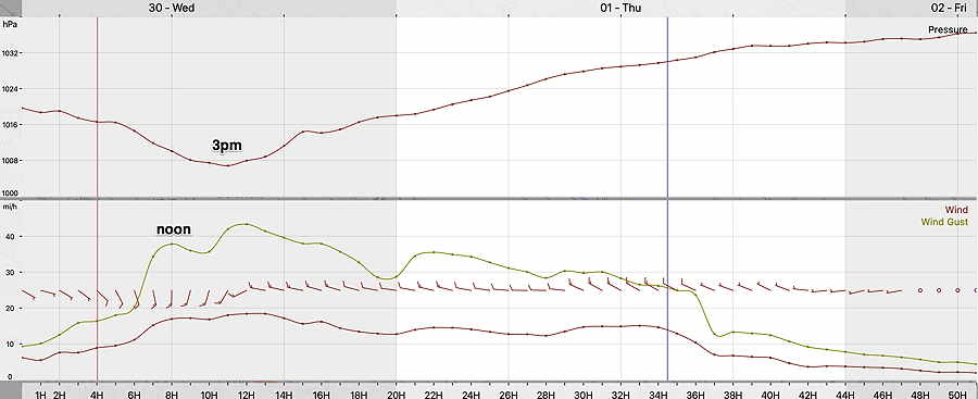
Update Wed 11/30 @ 8:04 AM — Last night’s models show little change in the forecast. The cold front comes through about 3 PM with strong wind gusts starting around noontime. Rain this morning precedes the frontal passage.
With Twitter’s change in ownership, I am suspending auto-posting to the Twitter site and will continue to evaluate the situation. Those of you using Twitter can learn of theweatherguy.net updates by following me on Mastodon. ( Read more here. )
Wednesday Forecast Update
Update Tue 11/29 @ 5:41 PM — We’re back to a frontal passage between 2 and 4 PM with rainfall about 0.5 inches. Rain starts in the morning Wednesday, about 8-9 AM.
Winds increase early afternoon with many models exceeding 40 mph wind gusts and with some approaching 50 mph.
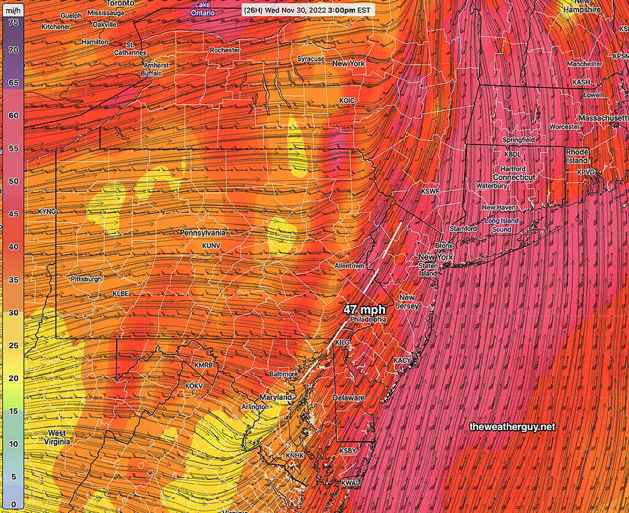
Here’s the latest GFS (18z) wind gust forecast for 3 PM Wednesday—
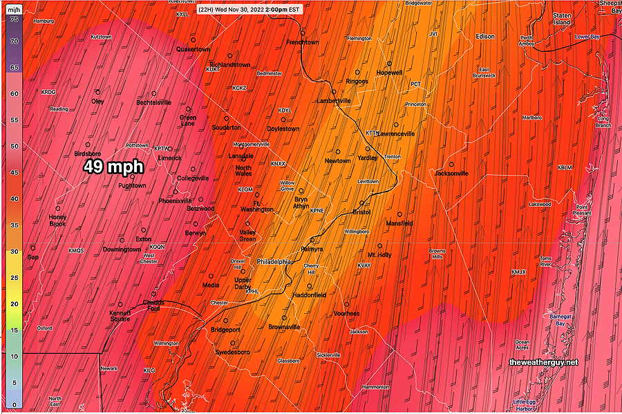
Here’s the latest RAP model (21z) wind gust forecast for 3 PM—
Update Tue 11/29 12:22 PM — The latest models show the front moving through here somewhat earlier on Wednesday than previously forecast. Current timing for the frontal passage about 12-2 PM with the highest wind gusts (40-50 mph) around that time. Total precipitation in our immediate area is now forecast to be only about 0.40-0.50 inches.
Update Mon 11/28 @ 8:22 PM — Heavy rain and high winds Wednesday afternoon between 2 and 6 PM. The strong cold front mentioned in the “week overview” below looks like it might pack a punch as it moves through between 2 and 6 PM (peak probability 3-5 PM).
Rainfall 1.0 inches (CMC-GEM) to 1.4 inches (NBM) are possible in a few hour period. Wind gusts 40-50 mph possible.
Previously Posted Mon 5:52 PM —
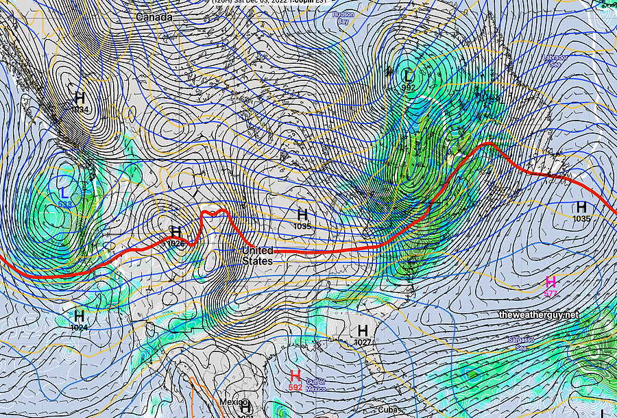
Week Overview
Two weather events for this coming week, currently timed for Wednesday and Saturday. There’s good agreement in the models for Wednesday’s rain. There’s less agreement in the timing for Saturday’s rain.
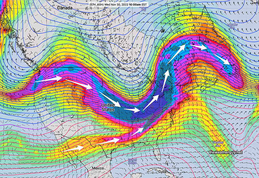
The jet stream will be making some significant changes over the week as cold high pressure pushes the jet flow down into our area on Wednesday with milder temperatures becoming colder by Thursday as a strong cold front moves through—
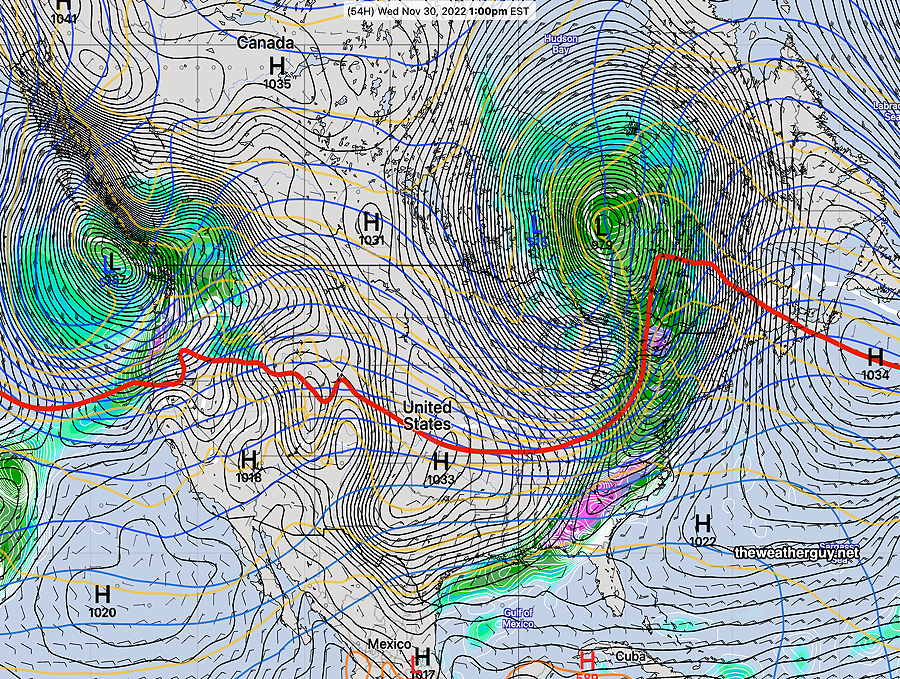
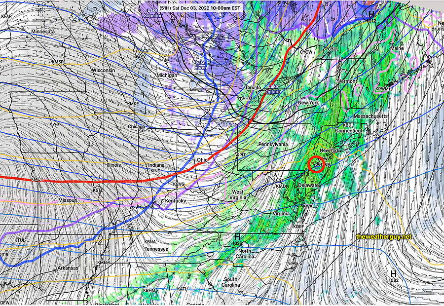
Here’s what the surface map is forecast to be Wednesday at 1 PM with the cold front approaching the Delaware Valley—
High pressure builds in for Thursday and Friday. Another dip in the jet flow will bring another cold front through on Saturday—
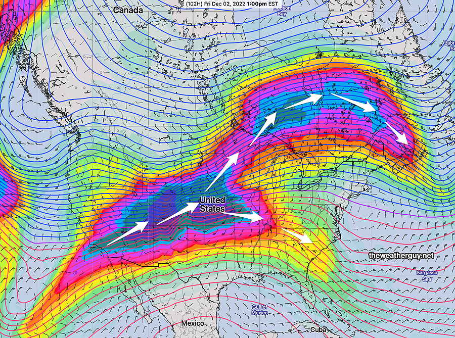
Surface forecast for Saturday—