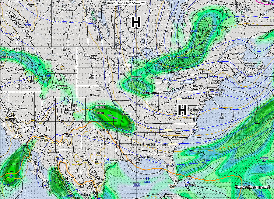
What appears to be a changed weather pattern has taken hold with an upper level trough in the eastern US with surface level high pressure. A mostly dry and cooler pattern will result.
06zECMWF-AI forecast for Thursday at 8 AM. High pressure over our area. A cold front near the Great Lakes may bring light showers later Friday, but a mostly dry and cool pattern overall. (Click on image for a larger view.)
Mon 10:00 AM —Forecast Review — Last evening’s late posting showed major differences in forecasting between the HRRR & NAM-NEST model forecasts and the new, soon to be released (I hope), RRFS experimental model. (RRFS– Rapid Refresh Forecast System, an hourly updated model with the 00z 06z 12z and 18z runs forecasting out to 84 hours.)
The RRFS, at least in last night’s situation, demonstrated a superior forecast to the existing older models.
No specific release date has been made for the RRFS and its ensemble version, the REFS, but early 2026 is a good bet.
The NWS has already solicited comments regarding planned discontinuation of several older models including the SREF and the HRESW models. Likely to be included in the discontinued list will be the NAM.
The RRFS and the REFS have clearly been developed to replace the functionality of the older models. I’ve been using the RRFS experimental version as my principal model over many months now and the RRFS appears to be, overall, an improvement in forecasting.
Showers early Monday morning?
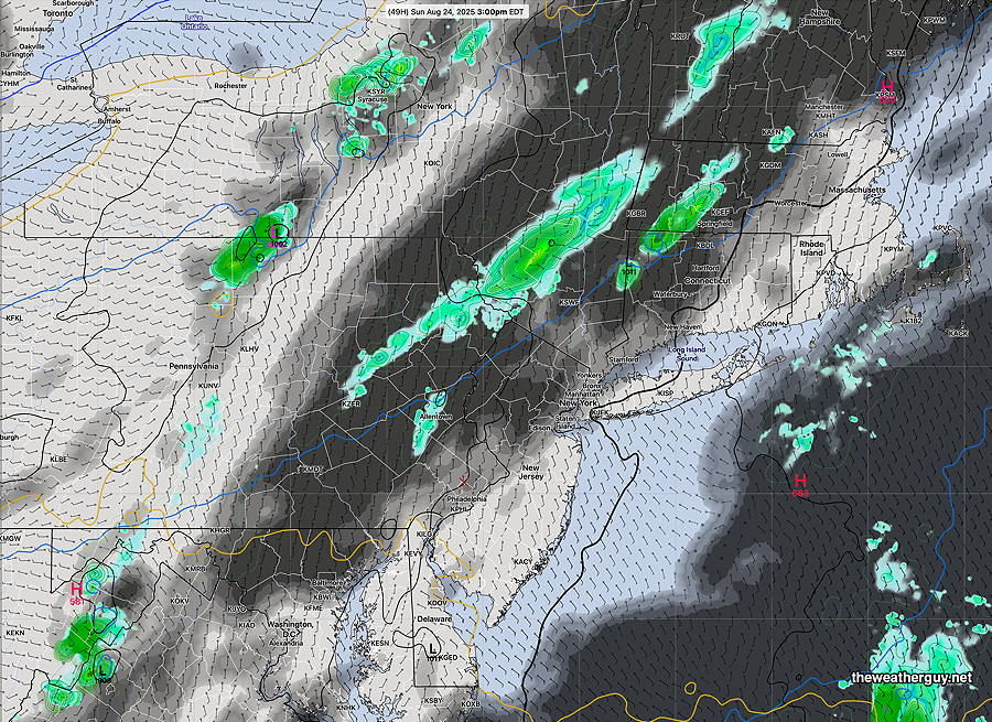
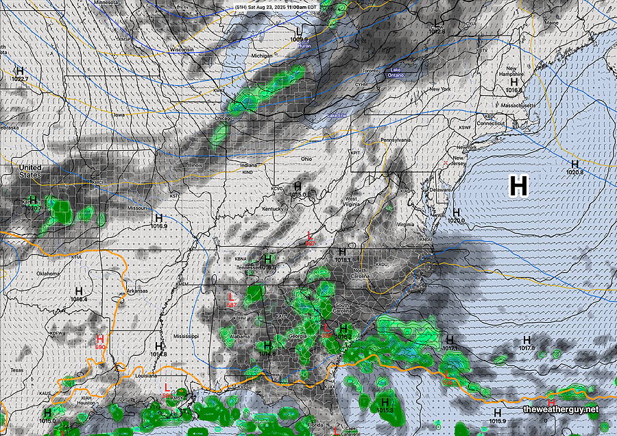
Posted Sunday 08/24/25 @ 11:20 PM — An interesting setup for early Monday morning. The 00z NAM-NEST and 00z HRRR show a broken line of showers and possibly thunderstorms moving through about 5AM -6 AM. The experimental 00z RRFS shows almost nothing. It will be interesting to see what happens.
Sunday Update
Posted Saturday 08/23/25 @ 9:13 PM — Sunday looks to be dry. All models show the line of showers that moves to our west will fall apart. A few sprinkles are possible from this same system before daybreak Monday.
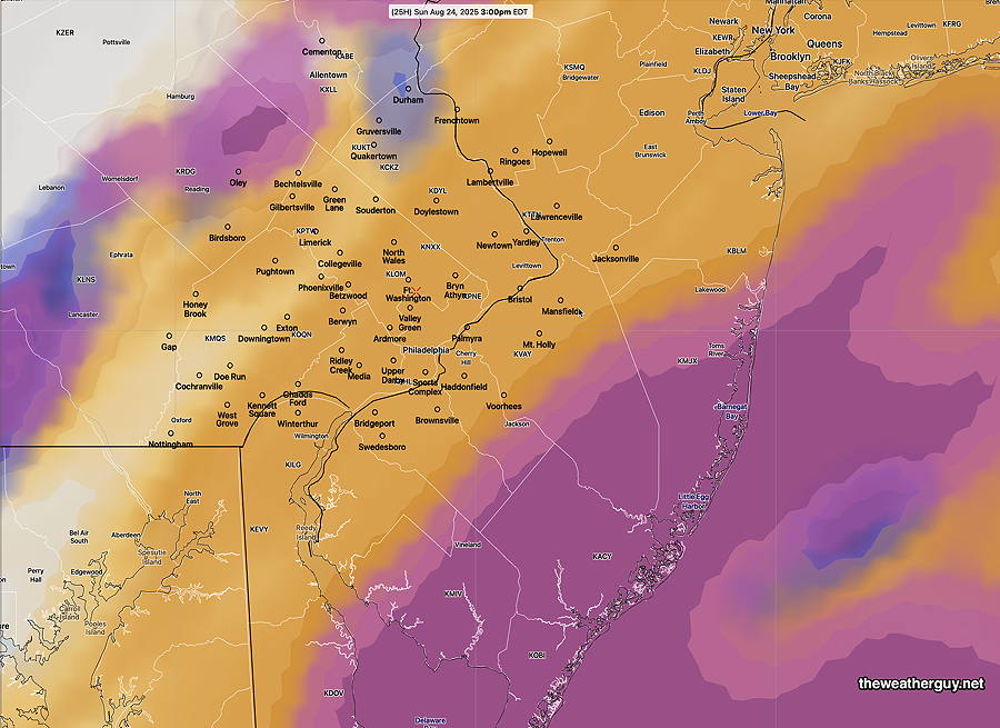
Also on Sunday, a weak system in the western Atlantic will bring some clouds to NJ, both in the morning and again the mid afternoon Sunday. The Philadelphia area will see a very thick layer of cirrus clouds, but dimmed sunshine should be able to pass through.
18z RRFS model forecast for 3 PM Sunday. Thick layer of high clouds (tan) around the city. Dimmed sunshine. More cloudiness at the shore (mid level clouds- maroon) at the shore. (Click on image for a larger view.)
The coming week looks dry. No systems expected to bring any rain. So we’re in another dry spell.
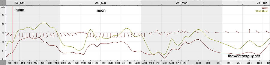
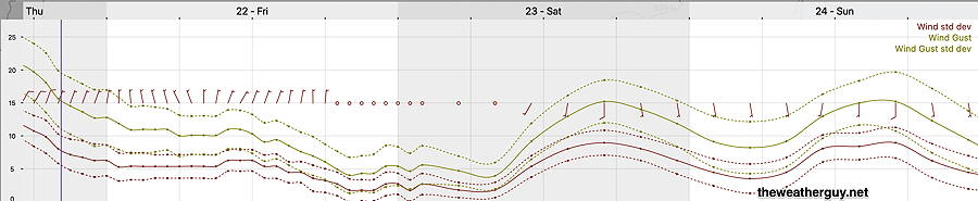
Posted Saturday 08/23/25 @ 9:58 AM —The latest model guidance shows it being a bit more windy today (Saturday) than previously forecast. Otherwise, beautiful.
Here’s the wind meteogram for Blue Bell, PA—
06z RRFS forecast wind speed/gusts for grid point Blue Bell, PA Saturday through Monday. Gusty winds towards evening from the south, then southeast. (Click on image for a larger view.)
Originally Posted Fri 9:56 PM —The beautiful weather will continue through early Sunday. High pressure maintains its hold through Saturday, but a southeasterly flow from a newly formed weak coastal low and a front to our northwest that loses its upper air support will bring a bit more humidity and some cloudiness for Sunday afternoon and evening. (The shore stays sunny, according to the RRFS.)
18z RRFS clouds/precip at 3 PM Sunday. Approaching front falls apart due to wide, diffuse and split jet streak aloft. (Click on image for a larger view.)
Showers originally expected for Sunday afternoon will likely fall apart as they approach Philadelphia due to a diffuse, broken jet streak.
Saturday Forecast
Sunny and quite nice. High 84° Blue Bell, 83°Philadelphia (not a typo)
Sunday Forecast
Somewhat increased humidity, but dew points still in the low 60s. High thin clouds in the morning lower to mid level clouds in the afternoon. No showers expected until later in the evening. Most areas may receive little or no rain; any rain will be light.
NBM high temperatures: Blue Bell, PA 84º Philadelphia, PA 83º Uncertainty (based on standard deviation): ±1.4º
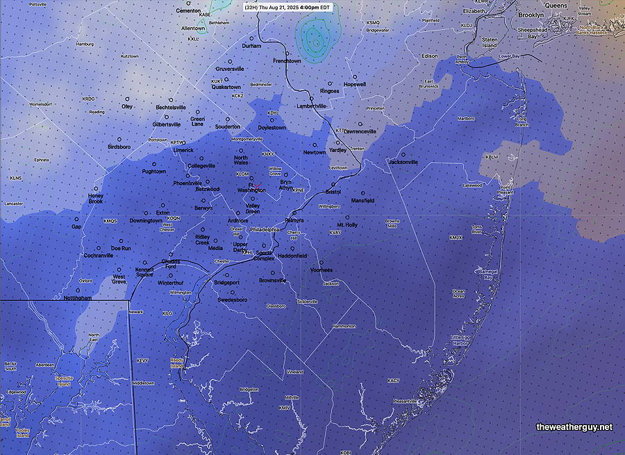
Posted Thursday 08/21/25 @ 8:11 PM — High pressure builds in for Friday and Saturday. Sunny skies!
12z GDPS with “AI Spectral Nudging” forecast for Saturday at 11 AM High pressure in control! (green=1 hour accumulated precipitation; black/grey= cloud cover) (Click on image for a larger view.)
The very breezy, gusty conditions we had today will diminish on Friday into Saturday. An approaching cold front will bring breezy gusty conditions back on Sunday.
18z NBM wind meteogram forecast for Blue Bell, PA (Click on image for a larger view.)
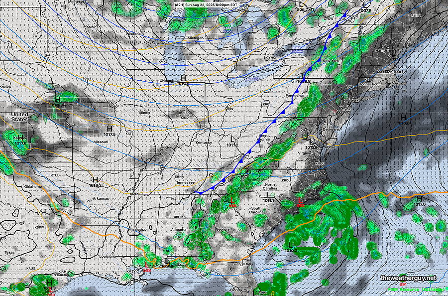
Sunday will see an approaching cold front with increasing cloudiness. Showers likely by evening.
12z GDPS with “AI Spectral Nudging” forecast for Sunday 6 PM (Click on image for a larger view.)
My regular Weekend Weather Forecast will be posted late Friday afternoon.
Thursday Forecast
Posted Wednesday 08/20/25 @ 7:30 PM — The wind flow has shifted from easterly to northeasterly and this will eventually pull in some drier air aloft and at the surface on Thursday, clearing some of the cloud deck.
There’s not much consensus among the models when the clouds will lift and thin. Some models show clouds thinning for (maybe) some sun as early as noon or 1 PM. The two Canadian models maintain low clouds into late afternoon .
The latest model blend (NBM) leans toward mid to late afternoon, supported by the latest REFS and RRFS.
So I’m leaning towards this forecast: the morning will be cloudy with even some light sprinkles areas far north west and northeast of the city.
Clouds gradually thin mid to late afternoon. Look for gusty winds in our area that diminish gradually towards evening.
12z REFS cloud cover at 4 PM (Dark blue is low cloud cover) (Click on image for a larger view.)
Wednesday Forecast Update
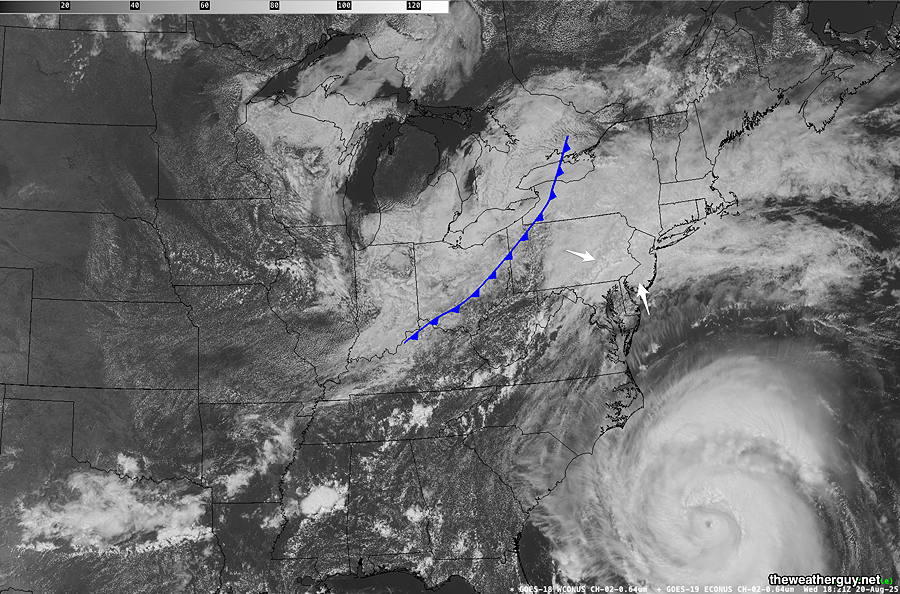
Posted Wednesday 08/20/25 @ 2:34 PM — The showers have developed as expected. Additional energy expected to move in during the next several hours, both from an approaching cold front and the outflow of Hurricane Erin—
Visible Satellite 2:21 PM with drawn approximate location of the cold front. Erin moving north at this time. (Click on image for a larger view.)
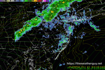
The latest available hourly RRFS model shows the potential/possibility of heavier showers or even some thunderstorms about 3-6 PM.
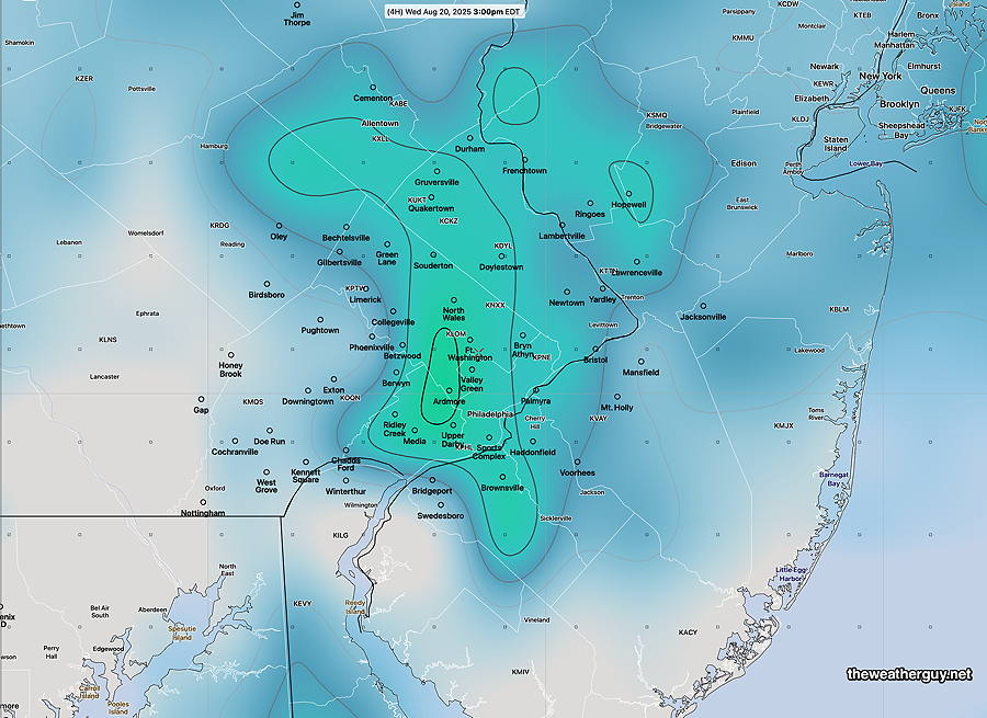
Current Radar 3:30 PM (Click on image for a larger view.)15z RRFS SWEAT INDEX. at 3 PM Low range, but suggests possibility of showers and even a few thundershower in the colorized regions. Not a sure thing. Hopefully, it won’t interfere with the Phillies game in progress. (Click on image for a larger view.)
As for Thursday, it currently looks a mostly cloudy day with some lingering showers early morning hours. I’ll update later today.
Posted Tuesday 08/19/25 @ 7:09 PM — The sunshine returned Tuesday afternoon, but it won’t last as a stalled front to our will try to move north as a warm front with additional moisture from the outflow circulation of Hurricane Erin. Expect scattered showers during the morning hours on Wednesday.
A cold front will try to move towards us on Wednesday afternoon, pushed by high pressure that will also take Hurricane Erin out to sea on late Thursday into Friday. Expect additional showers and possible thunderstorms Wednesday afternoon and evening.
18z Canadian RGEM model forecast for 3 PM Wednesday. Several areas of energy and moisture will converge on us, as discussed above.
As I’ve said several times over the past week, hurricanes seem to influence model forecast accuracy, so expect some changes and surprises. Updates tomorrow.
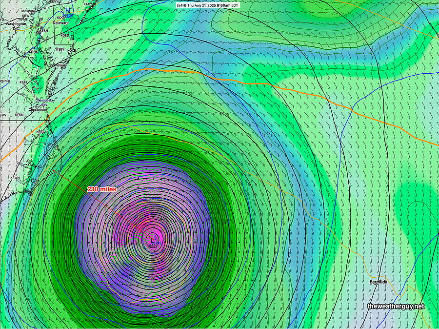
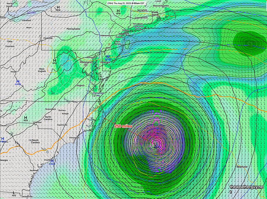
Posted Tuesday 08/19/25 @ 11:15 AM — Latest ECMWF-AI model has little change in the path of Erin, with closest approach now 230 miles form the NC Outer Banks.
06z ECMWF-AI Single forecast Thursday 8 AM, now back to 230 miles from the Outer Banks. (Click on image for a larger view.)
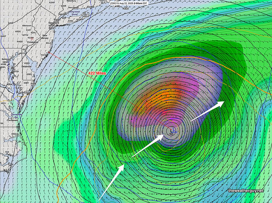
Also, unchanged is the rapid turn away towards the northeast. By 2 AM, it’s 422 miles from the NJ coast—
06z ECMWF-AI Single forecast 2 AM Friday morning. 422miles from the NJ coast (Click on image for a larger view.)
Unless there are changes, I’ll be tapering down my coverage of Erin, as it doesn’t pose a direct threat to our region.
As for our weather today (Tuesday), the there are interesting differences between the HRRR and the RRFS (experimental) The HRRR maintains low clouds here; the RRFS has clouds breaking for sunshine after noontime. I’m leaning towards some sunshine this afternoon, as the HRRR has a tendency to overestimate low clouds in our area.
Posted Tuesday 08/19/25 @ 7:58 AM— Several models are promising breaks in the clouds, and some sunshine in some areas, especially this afternoon.
No change with Hurricane Erin’s predicted track at this time, although the ECMWF-AI was again slightly more westward with its track last night.
Hurricane Erin Update
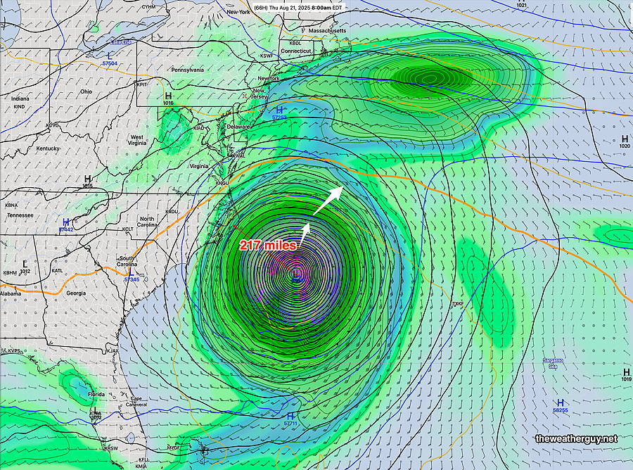
Posted Monday 08/18/25 @ 9:58 PM — The latest ECMWF-AI forecast continues its trend of a closer approach to the Outer Banks of NC. Now about 217 miles. Each model run has brought it slightly closer to the US coast before making a rapid turn to the northeast.
18z ECMWF-AI Single model forecast for 8 AM Thursday. (Click on image for a larger view.)
Tuesday, Wednesday, and Hurricane Erin
Posted Monday 08/18/25 @ 5:58 PM — We’ll continue to have an easterly flow of cool, moist air Tuesday and likely again on Wednesday. With the stalled front to our south, areas south of the city will continue to have a chance of showers. From the city and northward, there’s a chance of light drizzle or light sprinkles, but mostly cloudy covers it. Most of each day will be rain-free.
Again, with a nearby hurricane in the picture, the models often seem to have issues and forecasts can be a bit off.
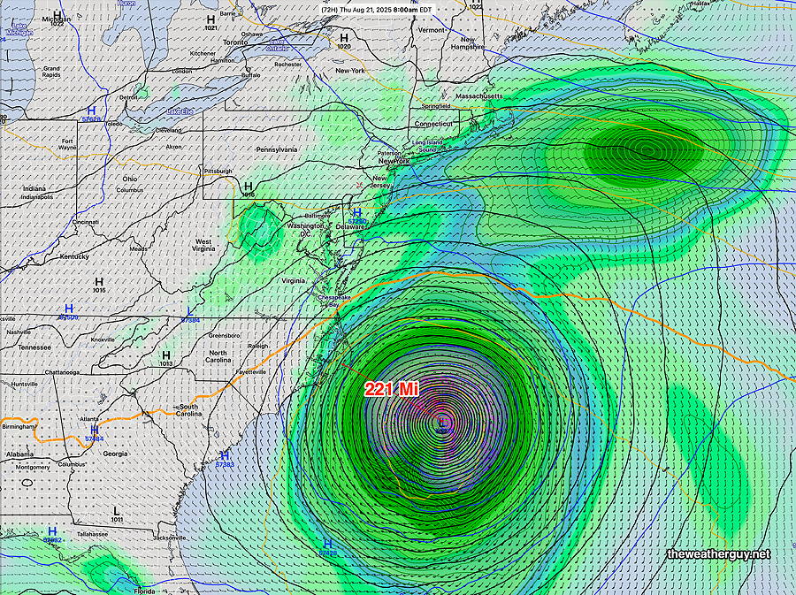
As for Hurricane Erin, there has been a subtle change with the ECMWF-AI model, with the latest having the storm about 225 miles away from the North Carolina outer banks. The trend has been for a slightly more westward track. The standard ECMWF model is even somewhat closer, about 200 miles or so. Our own GFS-AI model has been consistently 50-75 miles further eastward with its track position. Overall, there’s pretty good agreement, as hurricane forecasts go.
12z ECMWF-AI model forecast for 8 AM Thursday. (Click on image for a larger view.)
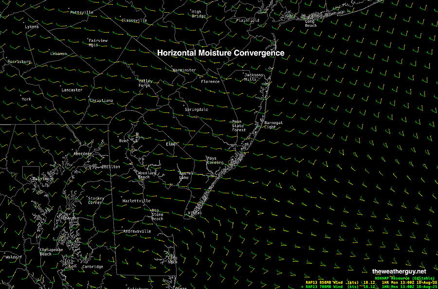
Posted Monday 08/18/25 @ 9:46 AM — I don’t know about you, but listening to the weather forecast yesterday, I would have guessed that today was going to be a beautiful day with cool temperatures. Well we have the cool temperatures, but it’s a cloudy day with light rain and drizzle in many areas.
The light rain is due to horizontal moisture convergence: low level moisture associated with winds moving in opposing directions causing lift. Here’s the current RAP model winds at about 5000 feet and 10,000 feet, showing opposing winds—
12z RAP model barbs showing winds at 5000 feet (yellow) and 10,000 feet (green) . With moisture, light rain and drizzle has resulted.
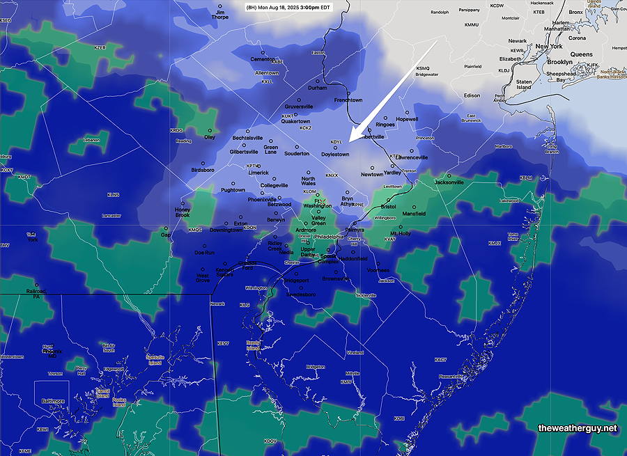
The latest experimental RRFS shows low clouds and a possibility of drizzle and light rain through 3 PM, with drier air moving in from the northeast, allowing clearing—
11z RRFS at 3 PM. Drier air moving in from the northwest. Blue- low clouds; green- “conditional probability of rain” (conditional probability of rain can suggest more precip than actually falls. It’s really used for determining precipitation type in winter, but I find it useful for to suggest the possibility of very light precip like drizzle.) Click on image for a larger view.)
As for Erin, the ECMWF-AI model is consistent with Hurricane Erin moving about 250 miles from the NC outer banks. Here’s it’s predicted position at 8 AM Thursday—
06z ECMWF-AI forecast for Hurricane Erin Thursday at 8 AM (Click on image for a larger view.)
As I’ve said many times in the past, it’s been my observation that hurricanes near the coastal US seem to affect model forecasts in seemingly unrelated areas. This is not a scientifically proven fact, just an observation I’ve made over the many years I’ve been forecasting. I don’t know why this happens, but today’s (Monday) weather is a case-in-point— I know that yesterday’s models didn’t show drizzle/showers this morning.
I think we’ll see more of these forecast issues this week with Hurricane Erin. Anyhow, let’s see if the showers really last into this afternoon.
Initially Posted Sun 11:16 PM —Cooler temperatures but plenty of clouds this week. Additionally, there’s the chance of showers especially south of the city. Indirect effects of Hurricane Erin also will come into play by Wednesday. More info Monday morning.