Update Fri 12/30 @ 9:36 AM — A quick update to the weekend outlook posted last night (below), based on the latest models.
Saturday will be quite cloudy. Some fog possible in the morning with low clouds throughout the day.
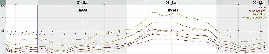
Some light showers are possible late morning and around noon especially just over the river in NJ. The bulk of the rain will be moving in between 2 and 5 PM around the city. Rain tapers off after midnight. Bulk of the rain is moving to our southeast and total rainfall will be less than 0.4 inches in or area.
NBM is showing a slight decrease in mean high temperature on Saturday to about 53º but it has increased its spread to 3.5º (So think of it as 53º ± 3.5º, a wider than usual range of uncertainty.)
For Sunday, New Year’s Day, skies clear during the morning hours. Winds and wind gusts still robust, but maxing out about 27-30 mph instead of the 35 mph gusts posted yesterday. NBM mean high temperature of 53º again with an even larger range of uncertainty, ± 4.0º.
I’ll update the forecast later today.
Previously Posted Thu 7:49 PM —
If you’re planning on outdoor activities, Friday will likely be the best day weather-wise of the coming three.
Friday
Sunshine with milder temperatures for Friday, with a high of 54º-55º. Thickening high level cirrus clouds expected mid to late afternoon.
Saturday and Sunday Outlook
Saturday will be cloudy. Scattered light sprinkles as early as noontime, but steadier rain moves in between 2 and 4 PM. It will be mild. Latest models have backed off on forecasting the heavy rain; light to moderate rain expected around midnight.
Sunday will continue mild and the sun should break out as skies clear. A big consideration will be the wind, with wind gusts around 30-35 mph, tapering later in the afternoon.