THIS WEEK’S WEATHER

#Philadelphia #weather #PAwx

Posted Thursday 03/14/24 @ 9:50 PM — We did reach an official high of 77º in Philadelphia on Thursday with sunshine. Could not have been a nicer day.

Friday will be cloudy with very light and widely scattered showers in the morning and afternoon as a weak cold front passes through. The cold front really just means a slight reduction in temperatures and a wind shift. The upper air dynamics will pass to our north and the latest models actually show minimal precipitation for us. Indeed, the HRDPS shows no rain at all in the immediate PHL area on Friday and the HRRR isn’t far from that.

Saturday looks very nice!

Another cold front comes through on Sunday.


Posted Thursday 03/14/24 @ 10:07 AM — The forecast for Friday has clarified as the GFS joins the rest of the models with rainfall of about 0.3″. Rain moves in during the early afternoon Friday.

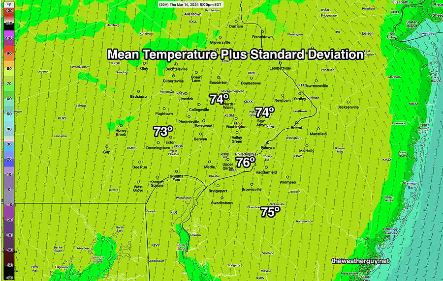
As for today, Thursday, the latest NBM appears to be running low again and this time with a standard deviation of over 3º, indicating high spread with the model forecasts. For today, we’ll use the Canadian HRDPS which tends to run just a bit high—

03-14-24 06z Canadian HRDPS high temps for today, Thursday. Contours are 1º intervals (Click on image for a larger view.)

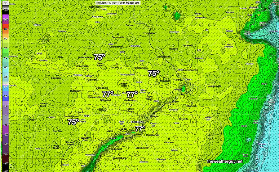
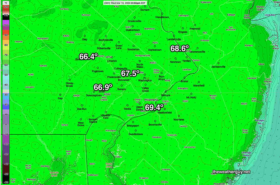
Posted Wednesday 03/13/24 @ 9:17 PM — Today’s high temperatures were predicted by the NBM, but only if the standard deviation was added to the mean temperature. The mean was too low, something I’ve seen before. With more sunshine on Thursday, I’ve taken the liberty to add the sd to the NBM mean temperature forecast for Thursday

As for Friday, a cold front moves through during the day. There’s a wide range of forecasts for Friday’s rainfall with the latest GFS having low pressure develop along the front with significant rain during the evening (0.8″) Most other models have significantly less (0.20″ -0.0.35″) The GFS has some light shower activity during the day Friday, with heavier rain at night. Other models are much drier during the day. So an uncertain forecast for Friday at this time.


Posted Tuesday 03/12/24 @ 8:53 PM — It still appears that we’ll have some mid-level cloudiness late morning into at least mid-afternoon on Wednesday. High temperatures upper 60s to approaching 70º in some areas—

03-12-24 18z NBM high temperatures for Wednesday All have a standard deviation of approx 1.6º which is normal uncertainty. (Click on image for a larger view.)

Posted Monday 03/11/24 @ 7:47 PM — A quick update to the forecast for the week. Latest GFS shows some cloudiness on Wednesday as warm air moves in aloft. Also, Thursday is now looking cloudy.

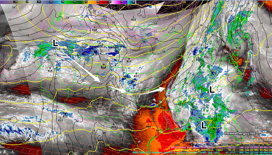
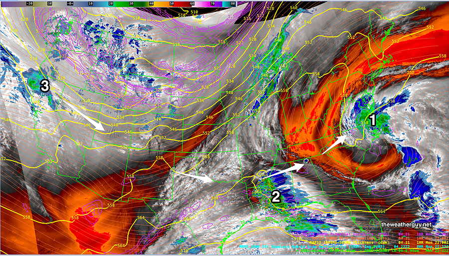
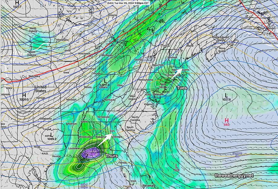
First Posted Mon 4:20 PM —Deep low pressure stacked vertically high in the atmosphere with a strong pressure gradient along with a strong jet flow aloft of over 200 mph has given us the high winds over the past 36 hours. It will move off to the northeast and winds should gradually subside.

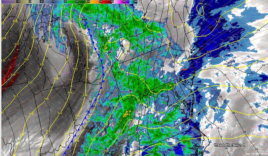
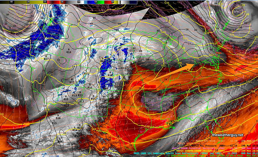
Here is the current satellite water vapor image showing the low pressure east of Maine and the next weather systems down the road—

Current satellite water vapor image with superimposed RAP model 500-1000 mb thickness lines (yellow), Mean Sea Level Pressure isobars (black contours) potential vorticity (fine violet contours) with superimposed MRMS RADAR. Warm dry air (orange shading) will move in for Tuesday through at least Thursday. (Click on image for a larger view.)

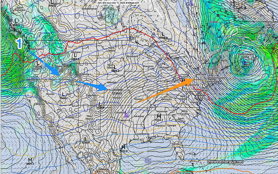
The weather map (NAEFS model) corresponding to the above water vapor image is below. A building ridge in the middle of the country will move eastward with warmer air. The system labeled (1) will affect our weather next weekend—

NAEFS statistical “mode” version model combined with GEFS “bias-corrected” precipitation model forecast for 5 PM today, corresponds to the above satellite image. (Click on image for a larger view.)

The warmer temperatures have been well advertised on the radio/TV weather. Here’s the NBM forecast highs for Blue Bell (add about 2º-3º for Philadelphia.)

03-11-24 18z NBM forecast high temperatures for Blue Bell, PA . Add about 2-3º for Philadelphia. (Click on image for a larger view.)

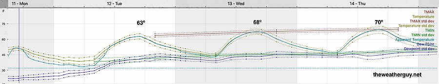
Overall, sunny through Wednesday. Some gradually increasing cloudiness on Thursday with the high temperatures at or above 70º

Weather and Standard Time-> Daylight Saving Time

Twice a year, I feel compelled to talk about Daylight Saving Time and how it negatively affects timely access to updated evening weather model data before bedtime for those of us on the east coast.

Frankly, I love Daylight Saving Time and the extra hour of daylight we get in the late afternoon. The problem for us weather people is that major weather models are run worldwide at “00z” (Coordinated Universal Time or what used to be called Greenwich Mean Time). This corresponds to 7 PM Eastern Standard Time, but 8 PM Eastern Daylight Time. That hour makes a big difference.

Since numerical weather models take 2-5 hours to ingest data, compute and process, many of the major models become available too late in the night to be any use for us on the East Coast for planning our activities the following day.

When you hear tune back in at 11″, you’re not going to see any change in the 5 day forecast at 11PM during Daylight Saving Time and you’ll likely see little change in the next day forecast; new model data simply hasn’t become available yet.

So for us weather people, the return to Daylight Saving Time has a negative impact on last minute evening updates regarding the next day’s weather.

Here’s some of the changes in some model availability (eastern time) :

Model Name (00z model run)Daylight TimeStandard Time
GFS 24 hour11:46 PM10:46 PM
GFS 5 day12:20 AM11:20 PM
NAM 24 hour forecast10:05 PM9:05 PM
NAM-NEST 24 hour forecast10:12 PM9:12 PM
HREF 48 hour forecast11:25 PM10:25 PM
Canadian HRDPS 24 hour forecast11:50 PM10:50 PM
Canadian RGEM 24 hour forecst12:10 PM11:10 PM
ECMWF*2:00 AM1:00 AM
ECMWF (free open data version)3:15 AM2:15 AM
* Partial runs of the ECMWF may be available earlier for paid subscriptions.

I’ve written extensively about Daylight Saving Time over the past years—

Little Known Facts about Daylight Saving Time and TV Weather Forecasts

Daylight Saving Time and Weather Models

“Check Back at 11” — TV Weather and Daylight Saving Time


WEEKEND WEATHER FORECAST

#Philadelphia #weather #PAwx

Sunday Forecast Update

Posted Sunday 03/10/24 @ 5:54 PM As forecast, rain and snow squalls are moving through now. Upper low is just north of us —

RADAR with RAP model overlay – mid level low just north of us. Snow squalls and rain squalls passing through (Click on image for a larger view.)

Posted Sunday 03/10/24 @ 4:40 PM — Here’s the MRMS tally of Saturday’s heavy rainfall—

MRMS combined rain gauge & radar-based measurement of actual rainfall received. Color shading is in inches. Line contour numbers are in mm (25.4 mm= 1 inch) Most areas west of the Delaware received about 1- 1.4″ (Click on image for a larger view.)

Posted Sunday 03/10/24 @ 10:26 AM — I had hoped to have a MRMS estimate of the rainfall we received last night. Unfortunately, the server I access for that info is down today; I’ll do that tomorrow.

Increasing winds and an increasing chance of light showers/squalls as the day progresses. Max probability is between 3 and 8 PM this evening as the upper low moves over us.

NAM-NEST forecast showing mid level low (L) over our area at 6 PM. Tightly packed isobars (black contours) show rapid gradient in pressure change responsible for the winds. (Click on image for a larger view.)

Winds/Gusts

NAM-NEST winds and wind gust meteogram for location Blue Bell, PA (Click on image for a larger view.)

Rain Update

Posted Saturday 03/09/24 @ 8:06 PM — The heaviest rain has moved in this evening and it is expected to taper off from southwest to northeast between 10:30 PM and midnight.

The surface low will be directly over us around this time and wind should diminish for about an hour or two. (Almost like being in the eye of a hurricane.) The winds will pick up and become gusty again. The windy conditions should continue through Sunday.

GFS surface forecast at 8 PM EDT Sunday evening. Upper (mid level) low is over NYC. Squalls with showers move through Pennsylvania. (Click on image for a larger view.)

Sunday is looking more and more unsettled, with plenty of clouds and wind. Wind gusts 40-45 mph. Some breaks of sun also. Intermittent light showers are possible, especially Sunday afternoon as the upper level low moves over us.

High temperatures will plateau around noon or 1 PM in the upper 40s and then drop during the afternoon. Continued fast moving light showers and even some squalls possible late afternoon. We may even see some snow flurries mixed in with the rain showers about 6-7 PM!


Saturday Rain Update

Posted Saturday 03/09/24 @ 9:35 AM — Last night’s models show little change in the storm forecast. Rain is showing already on radar, but much is not reaching the ground. A more significant batch of rain is quickly moving in from the southwest —

03-09-24 RADAR 9:22 AM Light precip not reaching the ground in many areas. Heavier rain just passing the Maryland – Pennsylvania border is moving fast and will be here shortly. (Click on image for a larger view.)

Satellite water vapor imagery shows the main event—

Current satellite water vapor image with superimposed RAP model 500-1000 mb thickness lines (yellow contours), Mean Sea Level Pressure isobars (black contours) potential vorticity (fine violet contours) with superimposed MRMS RADAR. I’ve drawn in the cold front, expected to reach us 2 AM Sunday, accompanied by strong winds. (Click on image for a larger view.)

Forecast rainfall totals have shown good continuity in recent model runs. Here’s the latest HREF ensemble forecast —

03-09-24 06z HREF total rainfall forecast. (Click on image for a larger view.)

Update Fri 3/08 10:07 PM — Tonight’s models continue with a trend towards an earlier start to the rain on Saturday. Scattered light sprinkles or drizzle may begin as early as 7- 8 AM, according to tonight’s NAM-NEST.


For Sunday there’s a chance of light widely scattered sprinkles with considerable cloudiness. High temperatures will be reached early in the day and temperatures will fall in the afternoon.


Previously Posted Fri 6:17 PM —

A strong low pressure system with plenty of moisture will move directly over Philadelphia Saturday night. The latest models are on-board with heavy rain especially in the evening.

As posted this morning, the energies of two jet streams will be coming together over our area—

GFS jet stream wind forecast for 9 PM Saturday. Highly cyclonic northern jet with strong southern jet. Faster areas in the jet stream are called “jet streaks”. The red box is an area called the ‘left exit region’ of the jet streak , an area of maximal upward motion. Heavy rain is most likely in this area, which will be just northwest of the Philadelphia region. Small changes in the position of the jet streak can result in major changes in forecast rainfall. (Click on image for a larger view.)

This energy will result in low pressure intensifying as it moves directly over Philadelphia Saturday night —

This afternoon’s GFS (03-08-24 18z) shows low pressure and heavy precip in the left exit region of the jet streak at midnight Saturday. (Click on image for a larger view.)

The NBM is cranking out high rainfall amounts with a fairly high chance of thunderstorms about 10 PM —

A cold front moves through about midnight. Sunday will be somewhat colder and very WINDY.

Saturday

Cloudy in the early morning. The latest models continue a trend of an earlier start of the rain. It now appears that it may start as early as 10-11 AM, earlier in western suburbs. Heaviest rain as we approach midnight. Increasing winds and a chance of thunderstorms about 10 PM.

NBM high temperatures: Blue Bell, PA 52º Philadelphia, PA 54º
Moderately high uncertainty (based on standard deviation): ± 3º

Sunday

Considerably cloudy and increasingly windy.

NBM high temperatures: Blue Bell, PA 49º Philadelphia, PA 51º
average uncertainty (based on standard deviation): ± 1.8º


THIS WEEK’S WEATHER

#Philadelphia #weather #PAwx

Friday and Interesting Saturday

Posted Friday 03/08/24 @ 9:36 AM — Sunshine through a thin layer of clouds this morning will give way to sunshine for much of the afternoon Friday. High cirrus clouds move in mid afternoon and cloudiness thickens by 5 PM from the southwest. Light winds today with highs 55º-57º.

An interesting setup for Saturday as two jet streams interact over us—

GFS jet stream wind forecast for 9 PM Saturday. Highly cyclonic northern jet with strong southern jet. Faster areas in the jet stream are called “jet streaks”. The red box is an area called the ‘left exit region’ of the jet streak , an area of maximal upward motion. Heavy rain is most likely in this area, which will be just northwest of the Philadelphia region. Small changes in the position of the jet streak can result in major changes in forecast rainfall. (Click on image for a larger view.)

There’s a wide range of model forecast rainfall amounts for Saturday, depending on each model’s forecast position of the jet. As little as 0.7″ to 2″ is forecast. Hopefully, we’ll have some clarification later.

Today’s NAM-NEST has joined yesterday’s ECMWF in forecasting light drizzle or rain as early as 11 AM Saturday. Likely time is 11 AM to 2 PM.

The above jet stream configuration will spawn strong low pressure that will pass right near us. Colder air behind the low will be give us a windy and cold day on Sunday.

Stay tuned for the Weekend Weather Forecast late this afternoon.


Friday Sunshine

Updated Thursday 03/07/24 @9:26 PM — Sunshine will make its appearance on Friday. There may be a period of cloudiness moving through in the morning hours. Some high cirrus clouds come in from the west around sunset. Somewhat breezy. Highs near 58º in the city, 56º in Blue Bell.

Saturday starts quite cloudy. Light drizzle or rain moves in from the southwest as early as 11 AM (ECMWF) but more likely around 12-2 PM. Heavier rain moves in by evening. Another 0.8″- 1.1″ expected. An easterly wind will keep it temperatures a bit cooler, in the low 50s.

03-07-24 18z [experimental] RRFS 1 hour rain accumulation by 1 PM Saturday. (Click on image for a larger view.)

Colder and windy on Sunday.


Thursday Update

Posted Thursday 03/07/24 @ 9:07 AM — We had a few bright spots and even some blue skies for a brief period west of the city this morning. However, an upper trough will swing through today and a mix of clouds is expected to return with even some drizzle in eastern NJ.

Last night’s HREF model most closely predicted this early brief clearing and here’s its forecast for 1 PM that includes the slight possibility of some drizzle or sprinkles —

03-07-24 06z HREF cloud and simulated radar at 1 PM today. (Click on image for a larger view.)

Sunshine for Friday


Forecasting Sun instead of Rain

Posted Wednesday 03/06/24 @ 4:50 PM — Over the years, I’ve hoped this web site would be come a destination for storm forecasts. After this week, I may need to rethink this and become the destination for when we’ll see the sun again.

The rain moved in pretty much on schedule Wednesday. A generalized 1.1″ to over 2 inches in NJ.

Today’s REFS (experimental RRFS ensemble) total rainfall. (Click on image for a larger view.)

There has been some question about whether the rain would linger well into Thursday.

It now appears that the rain will end during the early morning Thursday. No sun, but maybe some bright spots as varying amounts of low clouds appear to be the current model forecast.

Skies clear for Friday and we’ll see the sun return, but some cloudiness works its way back in Friday afternoon.

Saturday looks cloudy. Rain moves in early afternoon (1-2 PM, earlier western sections)


Wednesday Forecast Update

Posted Tuesday 03/05/24 @ 5:48 PM —The next system to bring rain will arrive as early as 11 AM Wednesday (earlier in S Jersey) . The system now appears to be somewhat elongated and is expected to bring heavy rain through at least Thursday morning. The heaviest rain will be along the NJ shore.

Current satellite water vapor (5:30 PM) mage with superimposed RAP model 500-1000 mb thickness lines (yellow), Mean Sea Level Pressure isobars (black contours) potential vorticity (fine violet contours) with superimposed MRMS RADAR. The next system arriving Wednesday morning has become somewhat elongated and rain will linger into Thursday late morning. Some of the models suggest light drizzle and slow clearing, so the ‘rain free’ period for Thursday afternoon mentioned in the earlier update may not occur. Friday still looks good. (Click on image for a larger view.)

Yet Another Update- Looking for Sunshine

Posted Tuesday 03/05/24 @ 11:50 AM — Looking for a break in the rain, the latest GFS suggests that the rain ends late Thursday morning and we may be rain free from that point through Friday.

It looks like we’ll have sunshine on Friday. Cloudy on Saturday with rain mainly far western areas early. Rain moves into the immediate Philadelphia during the mid afternoon Saturday.

Tuesday Rain Update

Posted Tuesday 03/05/24 @ 10:56 AM — Over the weekend, it appeared that we might have some significant breaks between the low pressure systems expected this week. That’s looking less likely through Thursday.

We’ve had the rain since last night (total amounts less than forecast except in NJ) , but currently we have the low pressure center just approaching our area—

Current (~10:30 AM) satellite water vapor image with superimposed RAP model 500-1000 mb thickness lines (yellow), Mean Sea Level Pressure isobars (black contours) potential vorticity (fine violet contours) with superimposed MRMS RADAR. Additional light rain and drizzle is expected until about 5 PM or so.

We’ll have a break in the rain tonight (still damp) but the models are showing rain moving back in as early as 11 AM to 1 PM on Wednesday—

03-05-24 06z REFS (experimental) 1 hour rain plus standard deviation at 1 PM Wednesday. (Click on image for a larger view.)

An additional system is forecast to move in on Thursday. There may be little to no break in the action .


Rainy Tuesday and Wednesday and Saturday!

Posted Monday 03/04/24 @ 5:51 PM — Low pressure is forming as expected and rain will move in after midnight tonight and likely continue on and off until about 4 PM Tuesday.

Another system seems to have accelerated and will be here on Wednesday. Another system arrives Saturday, possibly sooner.

The latest water vapor satellite image captures the setup—

Current satellite water vapor image (5:30 PM ) with superimposed RAP model 500-1000 mb thickness lines (yellow), jet level wind streamlines (orange contour-arrows) potential vorticity (fine violet contours) and superimposed MRMS radar. Tuesday’s storm (1) is just to our south. Our next storm (2) has accelerated somewhat and will be here on Wednesday. It looks like another rainy Saturday as storm (3) will be ahead of a cold front. (Click on image for a larger view.)

Rainfall on Tuesday will be less uniform than last Saturday’s storm—

03-04-24 06z HREF accumulated rainfall forecast for Tuesday. (Click on image for a larger view.)

Previously Posted Sun 5:47 PM —

This Week’s Weather Overview

This week, we’ll see a continuation of the mild trend started this past weekend with a complex, split jet flow and an upper trough off of the southeastern US coast that will induce low pressure formation.

The latest ECMWF jet wind flow (300 mb level) shows the weak upper trough.

03-03-24 12z ECMWF 300mb wind speed and heights. Forecast is for Tuesday. I’ve drawn the trough axis in blue and accentuated the weak wind flow isopleths outlining the upper trough. Cold air remains above the 500 mb thickness line (dark red contour north ) and mild air southward. (Click on image for a larger view.)

Here’s the NAEFS forecast for Tuesday showing a near coastal low (very similar structured to the system that gave us the rainy day Saturday) —

03-03-24 12z NAEFS with GEFS bias-corrected precip overlay forecast for Tuesday. Low pressure over us on Tuesday. Another forming in near the Gulf will be here on Thursday. (Click on image for a larger view.)

It may get briefly colder next Sunday.