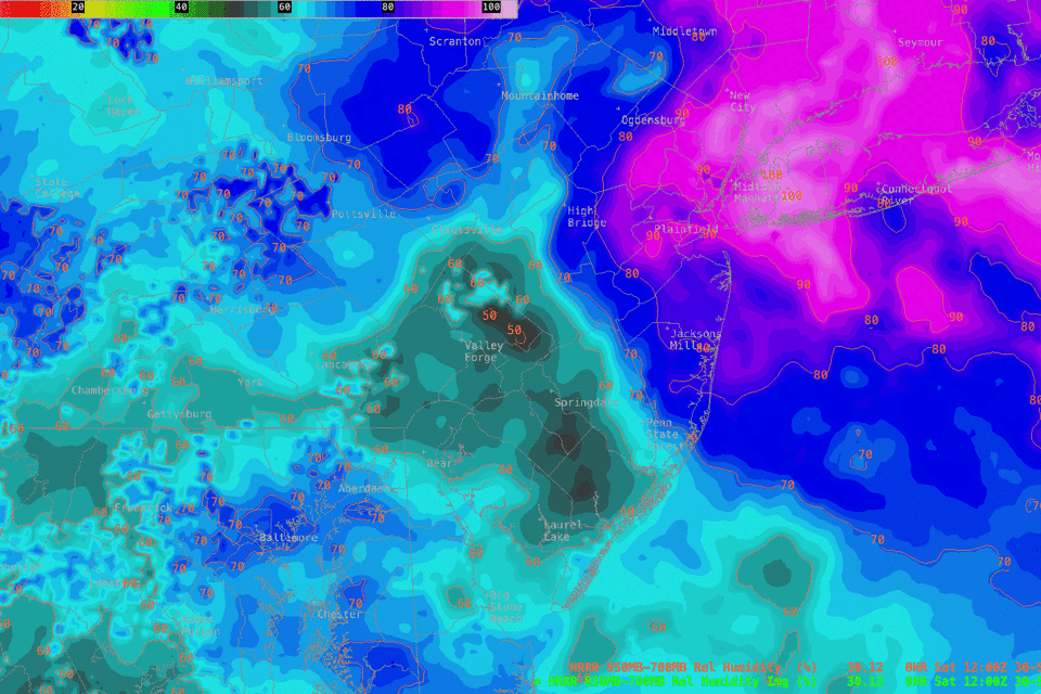
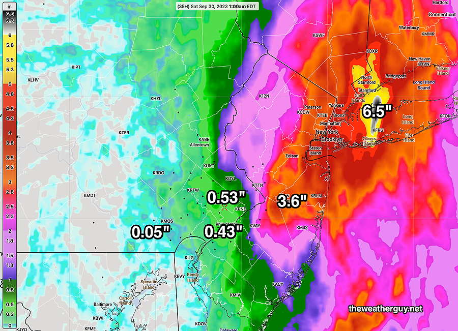
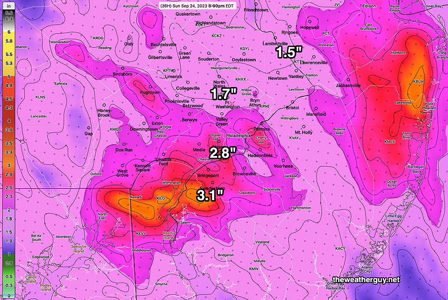
Update Sat 09/30 @ 9:33 AM — The previous post may have been too optimistic about clearing. This morning’s latest HRRR (12z) shows considerable moisture pushing back into the area, maintaining the cloud cover.
This morning’s 12z HRRR shows expanding humidity fields from the northeast, maintaining cloudiness. (Click on image for a larger view.)
Update Sat 9/30 9:08 AM — Little in the way of additional showers today in the immediate PHL area and west today. Last night’s models have some peeks of sun about 1 PM areas west of the Delaware River, but cloudiness may soon redevelop in the same areas. Any clearing this afternoon will be gradual with stops and starts, with the clearing process happening from northwest to southeast.
Previously Posted Fri 5:41 PM —
The coastal low combined with an mid and upper level low in Pennsylvania is bringing heavy rain to eastern NJ and NY.
The coastal low will depart Friday night, but the mid level low over Pennsylvania will wrap back some clouds and showers on Saturday morning. Clouds linger into the the afternoon, with skies gradually clearing between 3 and 5 PM from the northwest. (There are a few models that maintain the cloudiness until after sunset.)
High pressure builds in on Sunday to begin a week where a building upper level ridge will bring warm temperatures to our region—
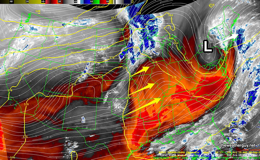
WV image Friday afternoon with superimposed RAP model jet winds also shows the yellow 576 thickness line running through Oklahoma, Kansas, and Nebraska . The 576 thickness line sort of captures the three dimensional outline of very warm air. This will move in our direction (yellow arrows) , bringing unseasonably warm temperatures to our region next week. (Click on image for a larger view.)
Saturday
Cloudy with lingering widely scattered showers in the morning. Very gradual clearing in the afternoon. We may see some bright spots by 3 PM but blue skies/sunshine may not be in the cards. Somewhat windy from the NNE.
My pessimism about clearing is based on the NBM model, which still shows plenty of low clouds and low ceilings at 3 PM—
Today’s 15z NBM shows low ceilings (dark shading) and high uncertainty in cloud cover (red-violet contours) at 3 PM Saturday. (Click on image for a larger view.)
High temperature 68.4º ( NBM model— location Blue Bell, PA) High temperature 69.3º ( NBM model— location Philadelphia, PA) (Temperatures ± 2.4º)
Sunday
Sunny and much milder.
High temperature 76.4º ( NBM model— location Blue Bell, PA) High temperature 77.1º ( NBM model— location Philadelphia, PA) (Temperatures ± 0.9º)
Friday Mastodon Update: Wxcloud.social, the Mastodon server I post to, is back online after having crashed last weekend. Unfortunately, all of my previously posted graphics are still missing. I am disappointed with this situation. I’d like to stay with wxcloud.social, but I have made no final decision in that regard.
I am now simultaneously posting to a separate, much larger Mastodon server, @theweatherguy@mastodon.social. My followers on wxcloud.social are encouraged to also follow me on mastodon.social, should problems reappear on wxcloud.social or I migrate to mastodon.social fully.
As I learned over recent days, if a small Mastodon server is shutdown or fails, all lines of communication with cultivated followers can be permanently lost.
Friday and Weekend Preview
Updated Fri 09/29 @ 9:36 AM — For the immediate Philadelphia area, cloudy with light scattered showers today. The models continue with most of the rain east of the Pennsylvania – New Jersey border. It doesn’t look promising for the Phillies game tonight in NY, but who knows, maybe they’ll play in the rain.
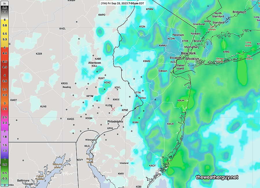
NBM hourly rain forecast for tonight at 7PM—
This morning’s 12z NBM hourly rain forecast at 7 PM Friday night. (Click on image for a larger view.)
As for Saturday, it looks like some showers still possible in the morning with low clouds hanging in for much of the day. Maybe some breaks in the clouds towards evening.
Sunday still looks quite nice!
My regular Weekend Weather Forecast will be posted later today.
Friday Forecast Update
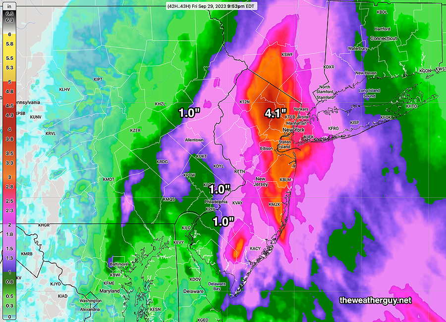
Updated Thu 09/28 @ 9:59 PM — Tonight’s latest NBM (00z) continues with a steep gradient in forecast rainfall for tonight into late Friday night.
There has been consistency with the forecasts, but some models (the HREF) has the 1″ rainfall totals a bit further westward, while the Canadian models are showing somewhat less rainfall overall. I’m going to hang my hat on the NBM—
Tonight’s NBM total rainfall by 8 AM Saturday. The 1″ line is somewhat further westward in to Philadelphia in the HREF forecast. Extremely heavy rainfall for NYC and CT. (Click on image for a larger view.)
Friday Outlook and Weekend Preview
Updated Thu 09/28 @ 5:17 PM — As mentioned this morning, the axis of heavy rain is trending further eastward and that trend continues with today’s 18z NBM—
This afternoon’s 18z NBM continues to forecast the heaviest rain to our east and that trend continues. The NBM now has the immediate Philadelphia area receiving less than 0.6 inches with the heaviest rainfall east into NJ. Rainfall totals are through Saturday (1 AM). Some areas are forecast to receive very heavy rain in NJ, NY and CT. (Click on image for a larger view.)
Saturday’s weather includes showers in the early morning, ending before noontime. We’ll see sunshine in the afternoon.
Sunday looks to be quite nice with highs in the 70s.
Next week looks to be nice and much warmer with temperatures approaching 80º
Thursday-Friday Forecast Fine Tune
Updated Thu 09/28 @ 9:46 AM — My earlier posted forecast violated the cardinal rule of weather forecasting:
“Always walk outside or put your hand out the window before making a forecast”
A light mist has developed in the immediate Philadelphia area, not really showing on radar, indistinguishable from background noise.
The latest NBM (12z), just available, shows the possibility of light mist/drizzle as early as NOW.
This morning’s 12z NBM model forecast simulated radar for 10 AM today. (Click on image for a larger view.)
So Thursday looks damper and somewhat wetter than previously forecast.
Updated Thu 09/28 @ 9:04 AM — It appears that Thursday will be just cloudy. While the latest NBM still has some light scattered sprinkles as early as 5-8 PM, any rain in the immediate Philadelphia area will probably wait for 11 PM to midnight.
While Friday is definitely going to be cloudy with low clouds and drizzle, there are varying forecasts for the amount of rain west of the Delaware river. The NBM has a fair amount of rain making it into Philadelphia, but the HRDPS has minimal amounts. All models have most of the rain in NJ, especially northern NJ and the trend has been increasingly eastward for the main rain axis.
Last night’s 07z NBM total accumulated rain forecast for late Tonight through Friday evening. These amounts are likely over-done(?). (Click on image for a larger view.)
Thursday – Friday Weather Outlook
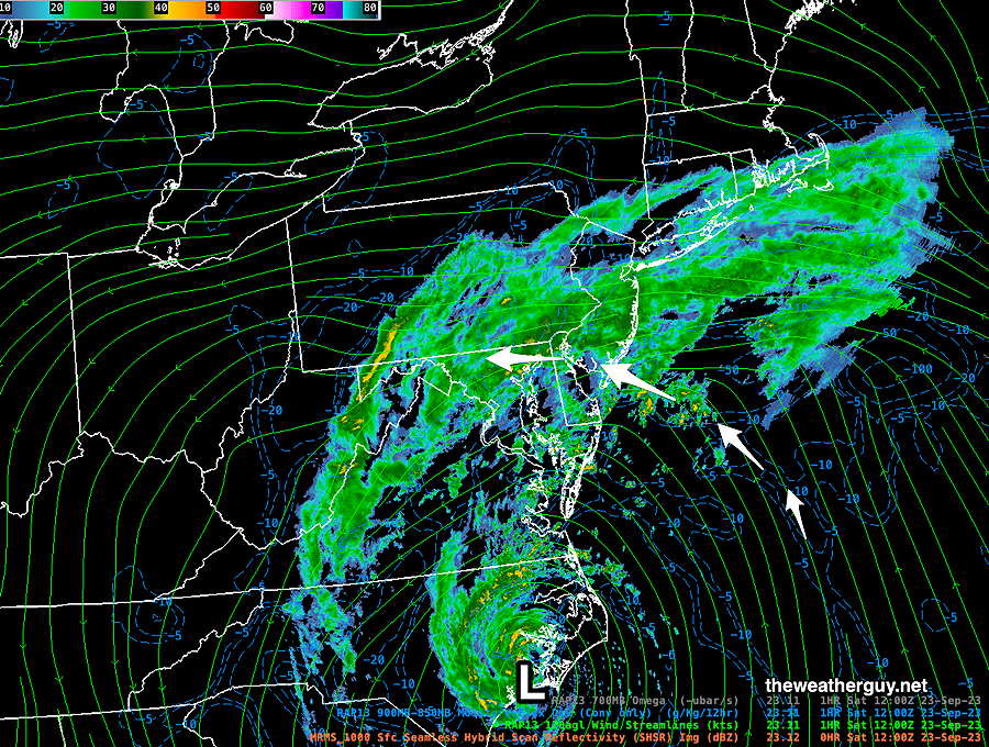
Updated Wed 09/27 @ 9:20 PM — An area of low pressure is developing in the same region as Ophelia had formed. The upper air flow is different this time around and this low is expected to brush our area with rain late Thursday into Friday as it moves out to sea. Additional support to this low will be provided by an upper low pressure system over the Great Lakes.
Here’s the current water vapor image at 9 PM tonight—
Water Vapor satellite image with RAP model jet stream wind contours tonight. Low pressure off the coast will bring moisture up into our region late Thursday into Friday. (Click on image for a larger view.)
For Thursday, sunny very early, then increasing low cloudiness. Cloudy by the afternoon. Light scattered rain develops between 5 PM and 9 PM, moving in from the southeast.
Friday will be a dark, cloudy day with light drizzle and light showers.
The weekend looks better, especially Sunday.
Wednesday and the Remainder of the Week Outlook
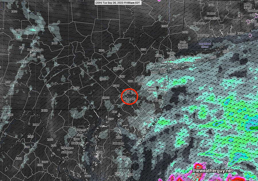
Updated Tue 09/26 @ 4:54 PM — Today was yet another day of dark skies and drizzle and occasional rain. The radar image taken earlier this today captures the flow—
Nexrad radar image late morning shows the light drizzle moving in on the easterly flow . Where the moisture encounters elevated terrain, the increased orographic lift results in more stationary areas of showers. A very interesting appearance. (Click on image for a larger view.)
Wednesday is looking dry, but still with considerable cloudiness. There should be some breaks of sun, especially northern suburbs.
Another coastal system will affect us late Thursday into Friday. A developing inverted coastal trough will bring rain on Friday, especially areas in NJ—
Today’s NAEFS forecast for Friday at 2 PM shows a coastal low/inverted trough moving close enough to bring showers to our area Friday. The track of this system will be move it eastward away from us by Saturday and Sunday as high pressure builds in from the west.
Tuesday Update
Update Mon 9/25 10:39 PM — Tonight’s models are suggesting that Tuesday’s weather will be more similar to Monday’s than previously thought. The NAM-NEST and HIRESW show low clouds, drizzle and showers, only tapering late afternoon. Additional rain accumulations expected, about 0.25 to 0.33”
Tuesday Outlook
Updated Mon 09/25 @ 5:31 PM —Monday was ‘dark with low clouds, drizzle and some scattered showers’ as forecast. Unfortunately, Tuesday’s weather is looking only slightly less dark. Plenty of low clouds and additional widely scattered showers and drizzle expected, but the areal coverage of the showers and drizzle lessens during the afternoon.
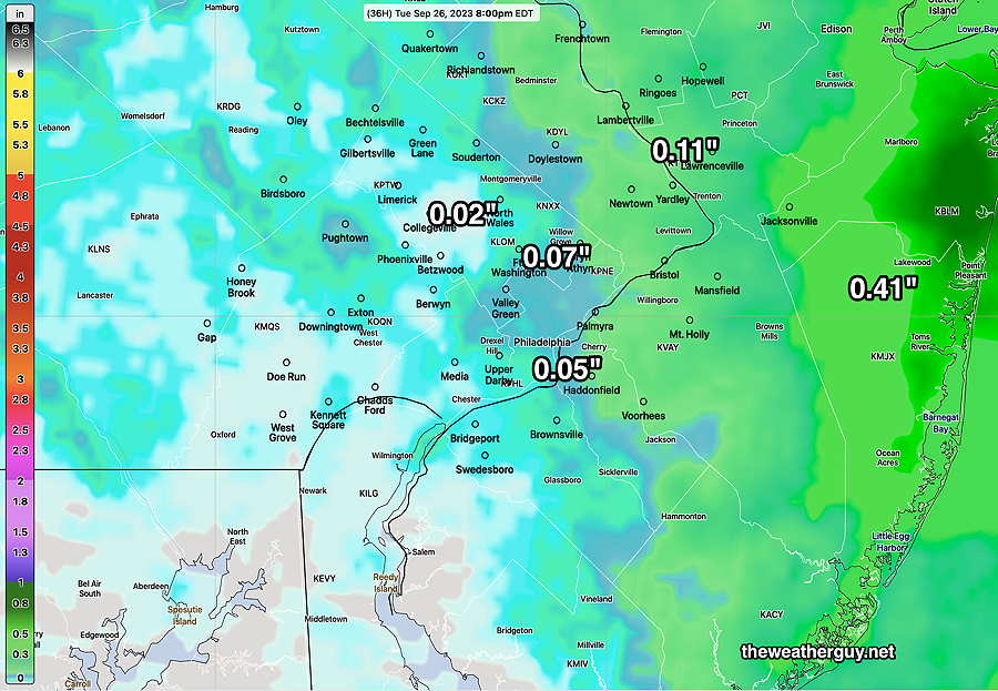
Here’s the latest NBM forecast showing clouds and drizzle/showers at 11 AM—
This afternoon’s 18z NBM forecast for clouds (black) and precipitation (green, light green) at 11 AM Tuesday. (Click on image for a larger view.)
There may be some brighter skies at times, but things really don’t improve until Wednesday.
Monday Update
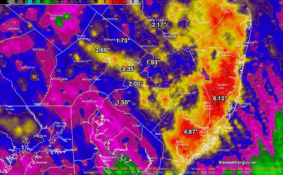
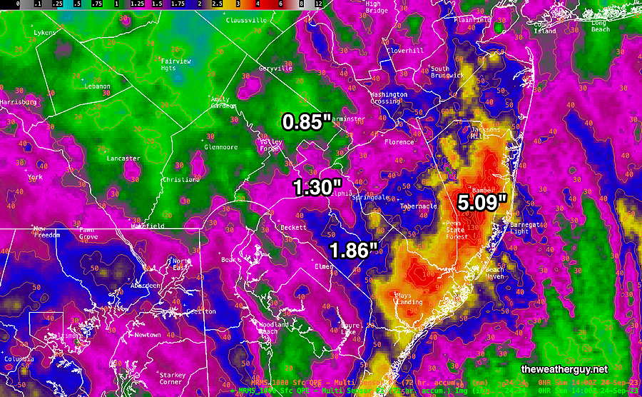
Updated Mon 09/25 @ 10:46 AM — We got a lot of rain this weekend. More dreary conditions expected today, but with much less additional rainfall.
How much rain did we get so far?
MRMS rain gauge-radar extrapolated estimate of rainfall over the previous 72 hours. (Click on image for a larger view.)
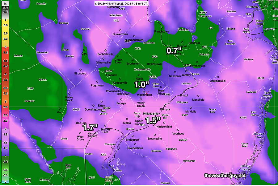
How much additional rainfall is forecast for today?
Here’s the latest NBM forecast rainfall for Monday —
This morning’s 12z NBM model total accumulated rainfall for Monday and Monday night. (Click on image for a larger view.)
Monday
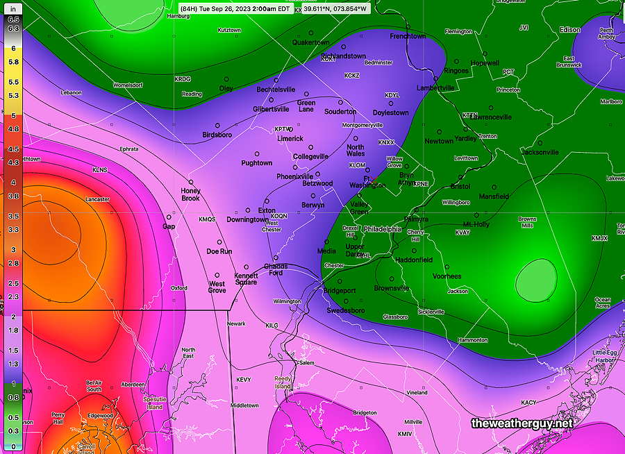
What was once a strong low pressure system in all levels of the atmosphere, the remnants of Ophelia will be a weak, closed mid-level (500 mb) low on Monday—
Today’s 18z GFS forecast for 8 AM Friday shows a mid level low over northwestern NJ. This low will gradually dissipate, but considerable low level moisture and a mid level cyclonic flow will cause low clouds, drizzle and some showers on Monday.
This low will gradually dissipate, but considerable low level moisture and a mid level cyclonic flow will result in dark, low clouds, drizzle and some scattered showers on Monday. No sunshine is expected.
Tuesday through Friday
We may begin to see some sunshine on Tuesday, but still with a chance of widely scattered sprinkles.
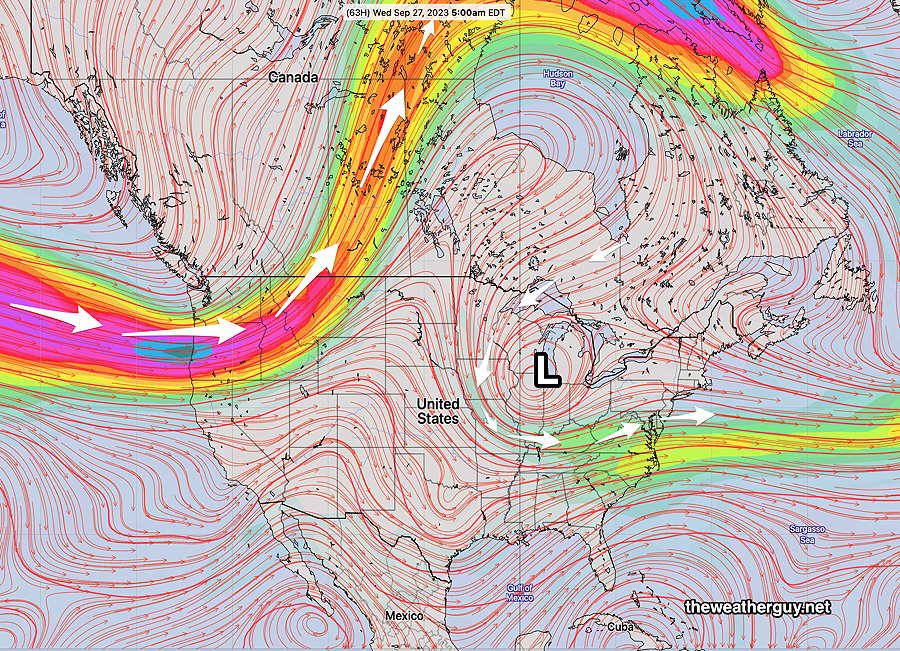
As for the rest of the week, we’ll be influenced by an upper level closed low that will keep us cooler than seasonal averages—
Today’s 18z GEFS jet stream forecast for Wednesday shows a closed low that will affect our weather through Friday. Cooler temperatures, but I’m not certain how sunny it will be. The models have surface high pressure giving us fair weather. I guess we’ll see.
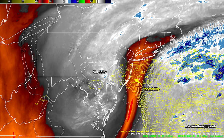
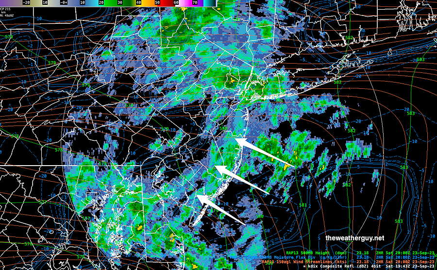
Updated Sun 09/24 @ 5:20 PM — The main area of rain is exiting our area, but continued light drizzle and showers are still forecast through the night.
Radar at 4:48 PM Sunday with superimposed RAP model jet level windstreams (orange) and moisture convergence (blue)
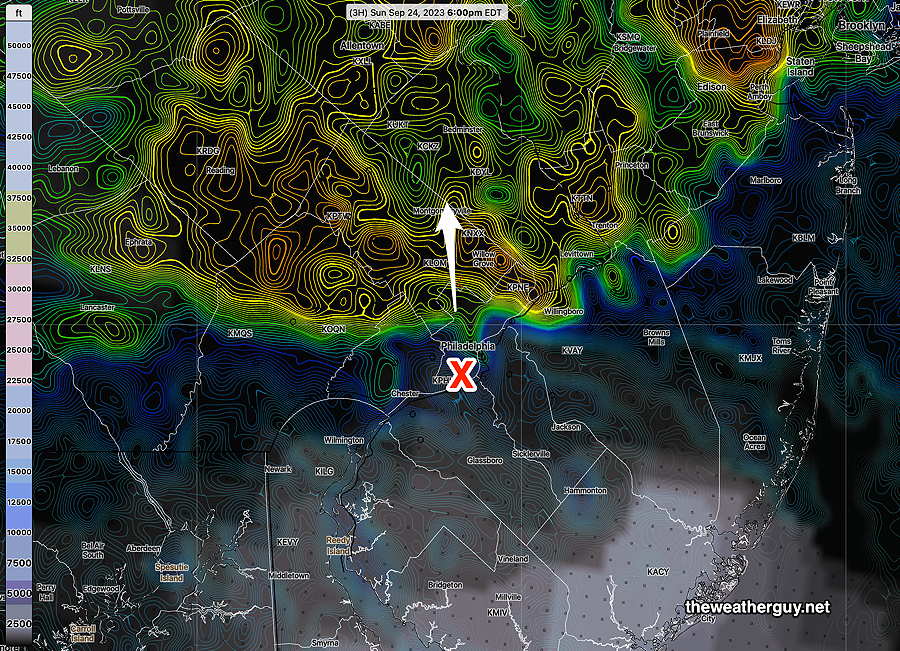
The NBM has the [heavy] rain exiting in time for the Phillies game at 6 PM—
Today’s 18z NBM simulated radar (colorized contours) and cloud ceiling at 6 PM. (Click on image for a larger view.)
Sunday Forecast Update
Updated Sun 09/24 @ 11:40 AM — Rain will continue through this afternoon and tonight. There may be some periods where the rain lets up, but expect it to return.
It looks like the mastodon wxcloud.social server is offline
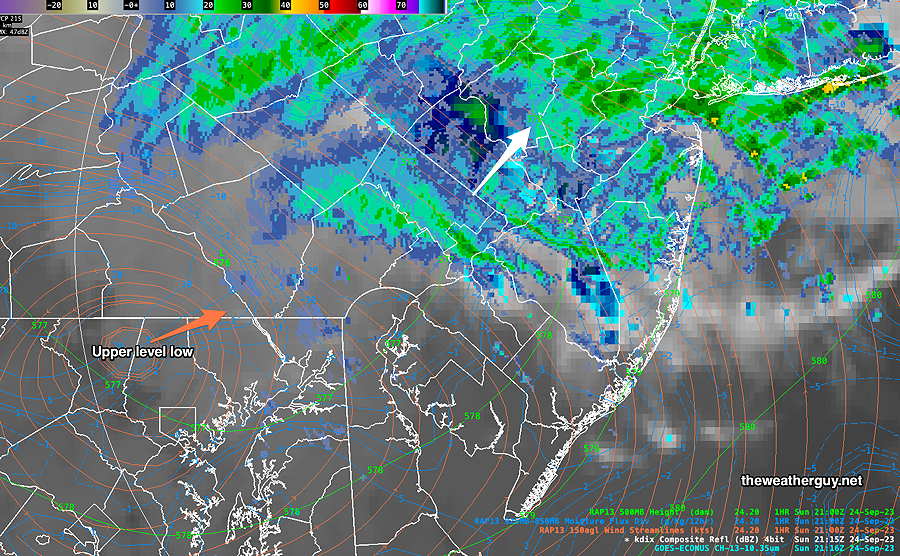
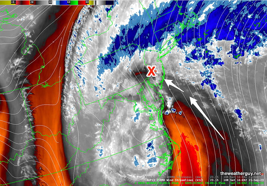
Current water vapor image with superimposed RAP model parameters shows an area of vorticity and instability approaching. Showers and even some thunderstorm activity is possible this afternoon —
Current WV and RAP potential vorticity and MUCAPE (Click on image for a larger view.)
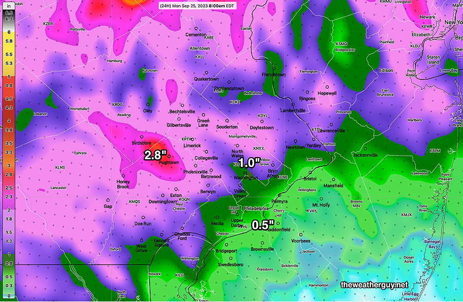
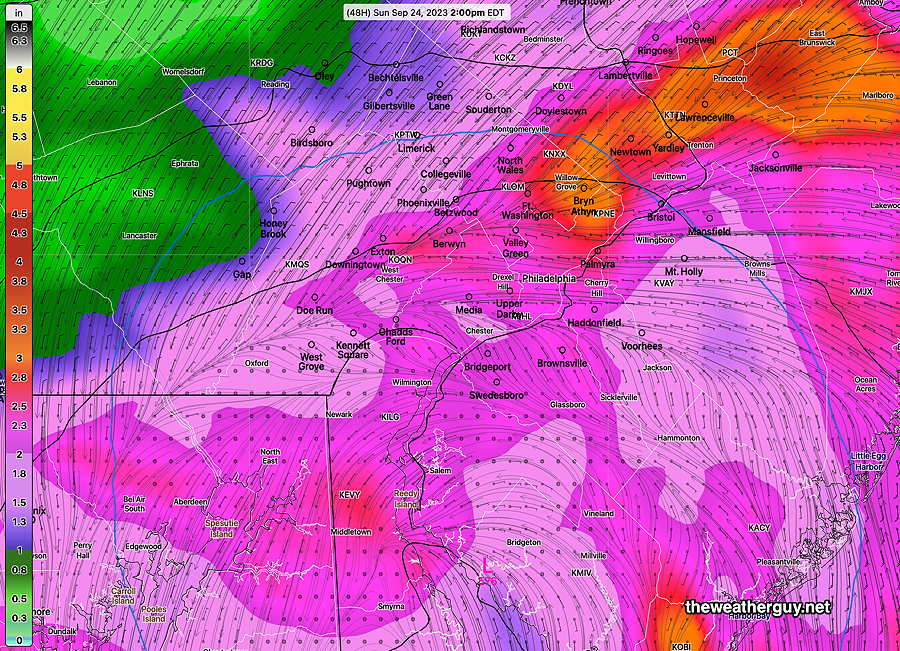
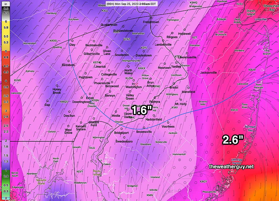
The latest HREF model shows considerable additional rainfall for our area for the next 24 hours—
This morning’s 12z HREF forecast for additional accumulated rainfall 8AM Sunday through 8 AM Monday. (Click on image for a larger view.)
Latest MRMS (10AM) total estimated rainfall over this weekend so far—
Sunday Forecast Update
Updated Sat 09/23 @ 9:46 PM — This afternoon’s and this evening’s early models have periods of rain continuing through the night and much of Sunday into Monday morning!
There may be a break in the showers in some areas around 9 AM Sunday, but showers will return by late morning.
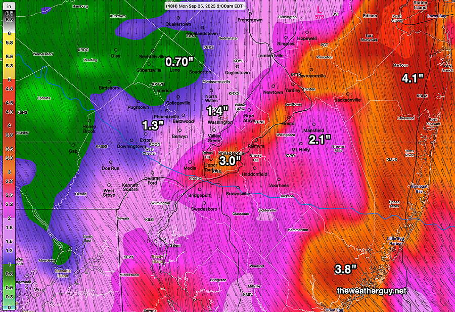
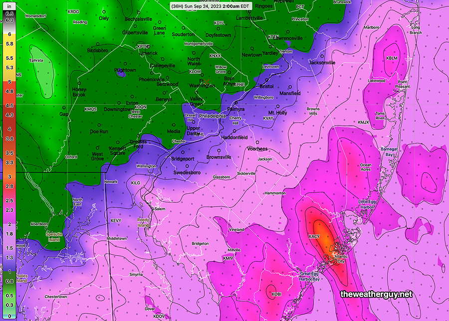
Tonight’s NBM just available shows an additional 1.5 inches of rain through 7 AM Monday morning—
Tonight’s 00z NBM accumulated rain forecast from 8 PM Saturday through 8 AM Monday. (Click on image for a larger view.)
Incredibly, the remnants of Ophelia may keep showers with us much of Monday and there’s even a chance of showers on Tuesday.
Are the Phillies going to play today?
Updated Sat 09/23 @ 3:52 PM — Despite the weather, the MLB app says the Phillies will play this afternoon. Here’s the current radar at 3:41 PM—
Current radar at 3:41 PM Saturday. (Click on image for a larger view.)
Saturday Storm Update
Updated Sat 09/23 @ 12:12 PM — Don’t be fooled by the breaks of sun we’re seeing now due to ‘dry slotting’. There’s plenty of rain and wind on the way.
Water Vapor image showing ‘dry slot’ moving in from the southeast. It won’t last. (Click on image for a larger view.)
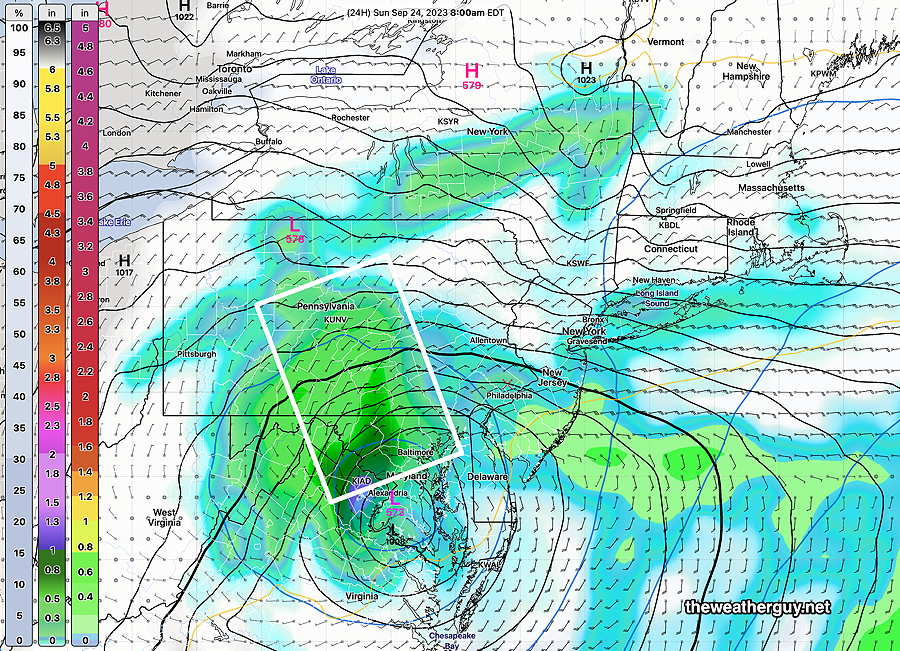
Updated Sat 09/23 @ 11:56 AM — As promised here is the latest GFS model, just available.
The GFS forecast position of the surface and upper low pressure at 8 AM Sunday—
GFS axis of heaviest rain on Sunday is much further west (white box) than previous forecasts which had the heaviest rain through Philadelphia. (Click on image for a larger view.)
This morning’s models continue with a similar forecast as those posted earlier with some differences—
Similarities:
Rain continues through Sunday.
Highest wind gusts to occur this afternoon and evening.
Model Position of upper low on Sunday is fairly similar.
Differences:
Axis of highest rainfall is further west with the GFS
I’m sticking with the HRDPS and NBM location of heaviest rain posted below.
Updated Sat 09/23 @ 10:11 AM — Latest (12z) NBM shows the expected additional rainfall forecast from 8 AM today through 8 PM Sunday evening—
Add these amounts above to the amounts from the MRMS graphic immediately below to get a handle on the total rainfall expected from this storm. (Click on image for a larger view.)
Updated Sat 09/23 @ 10:00 AM — Through 9 AM today, here’s the estimated rainfall received, based on the MRMS—
Received rainfall, MRMS estimated at 9 AM today. Contours are in mm. 25.4 mm = 1 inch. A large gradient exists in rainfall northwest of the city. Most models predicted this for today. (Click on image for a larger view.)
Updated Sat 09/23 @ 9:17 AM — I failed to mention with this update that at least half the rain from this storm will fall on Sunday, the other half today, Saturday.
Updated Sat 09/23 @ 8:54 AM — Ophelia has made landfall and is now a strong low pressure system. Here’s the current MRMS radar image with RAP model jet level windstream contours—
This morning’s 7:32 AM MRMS radar image with superimposed RAP Model streamlines. (Click on image for a larger view.)
The remnants of Ophelia are expected to curve back towards northern Delaware, as its circulation throws more moisture over our region.
No model will exactly predict the total amounts of rainfall in all locations, but I’m going to hang my hat on the HRDPS as a reasonable forecast—
Canadian HRDPS (06z) total rainfall forecast through 2 AM Monday morning. (Click on image for a larger view.)
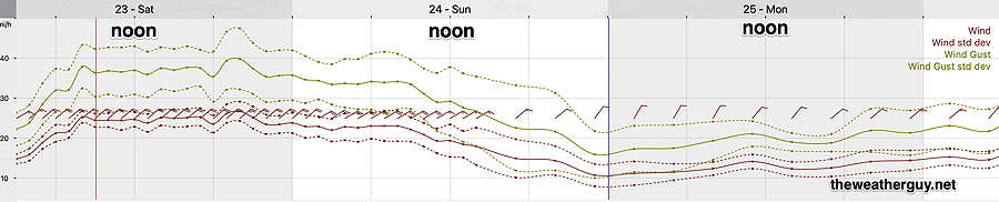
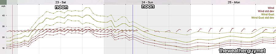
Current NBM wind forecast meteogram for KLOM (Wings Field, Blue Bell PA
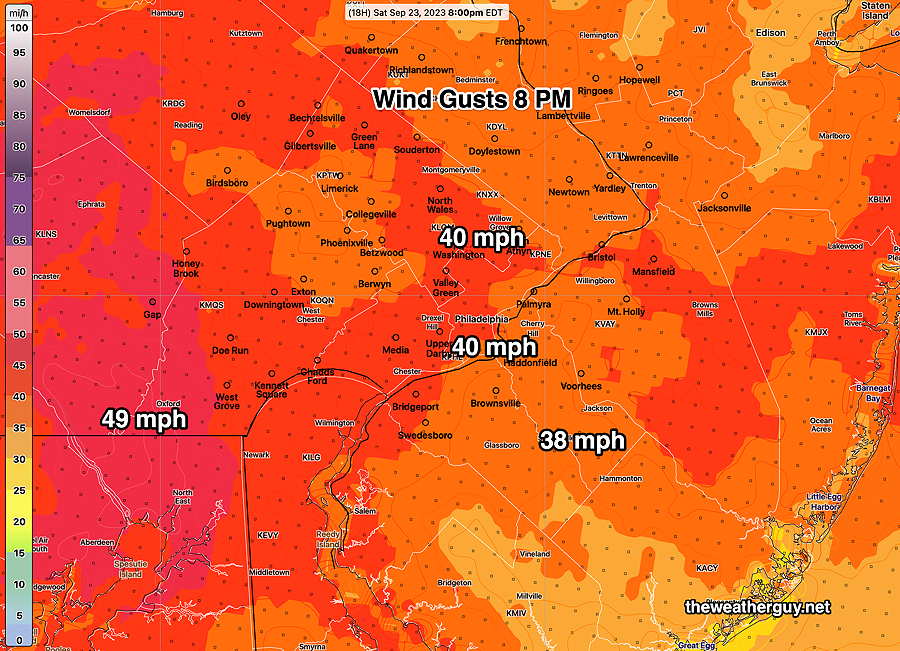
Here’s the NBM wind gust forecast for our region at the time of the scheduled Phillies game—
The next models, particularly the GFS, will become available about noon. I’ll update shortly thereafter.
Updated Fri 09/22 @ 10:32 PM — Tonight’s HRRR, RAP and the first 30 hours of the NAM. NAM-NEST and HIRESW models are in. The general trend is unchanged from my earlier 9:56 PM update.
The heaviest rains will be at the shore on Saturday, but significant heavy rain is forecast for the immediate Philadelphia area on Sunday. Totals for the two days remain a general 1.75-3″ in our area with 3-5+” possible as the shore.
Winds highest on Saturday. Here’s the latest NBM wind forecast for Blue Bell, PA—
Tonight’s 00z NBM wind meteogram for location Blue Bell, PA Mean Wind gusts 40 MPH. Standard deviation is dotted. (Click on image for a larger view.)
Update Fri 9/22 9:56 PM — The latest ECMWF and this afternoon’s NAM are forecasting the heaviest rain to occur on Sunday with the highest wind gusts Saturday afternoon and evening.
Updated Fri 09/22 @ 8:06 PM — The latest Canadian high resolution model (HRDPS) gives a very different forecast. This model only forecasts out 48 hours—
The latest (18z) HRDPS shows much heavier rainfall in our immediate area. The HRDPS was very good this past summer with thunderstorm predictions. I’m not sure that it will be as accurate with tropical or extra-tropical systems. (Click on image for a larger view.)
The HRDPS shows the highest winds about 9 PM Saturday evening.
Updated Fri 09/22 @ 7:54 PM — This afternoon’s GFS model has become available. It’s distribution of the heaviest rain is quite different than the earlier posted NBM model—
This afternoon’s (18z) GFS model shows most of the heaviest rain to the west of Philadelphia. Here’s the rain totals by Tuesday. (Click on image for a larger view.)
It should be noted that most models have reduced the peak wind gusts in our region to 35-40 mph on Saturday.
Previously Posted Fri 5:31 PM —
The model guidance was showing the development of this storm last weekend, which is impressive. At that time, I was saying that it looked like it would have “tropical characteristics” which meant that it had a warm core center.
Here’s the latest 12z NAEFS forecast for the current hour (4 PM Friday) showing the storm. The dull orange contour at its center is the 576 dm 500-1000 mb thickness line, indicating the storm’s warm core.
Today’s 12z NAEFS showing the Ophelia and its warm core center 9
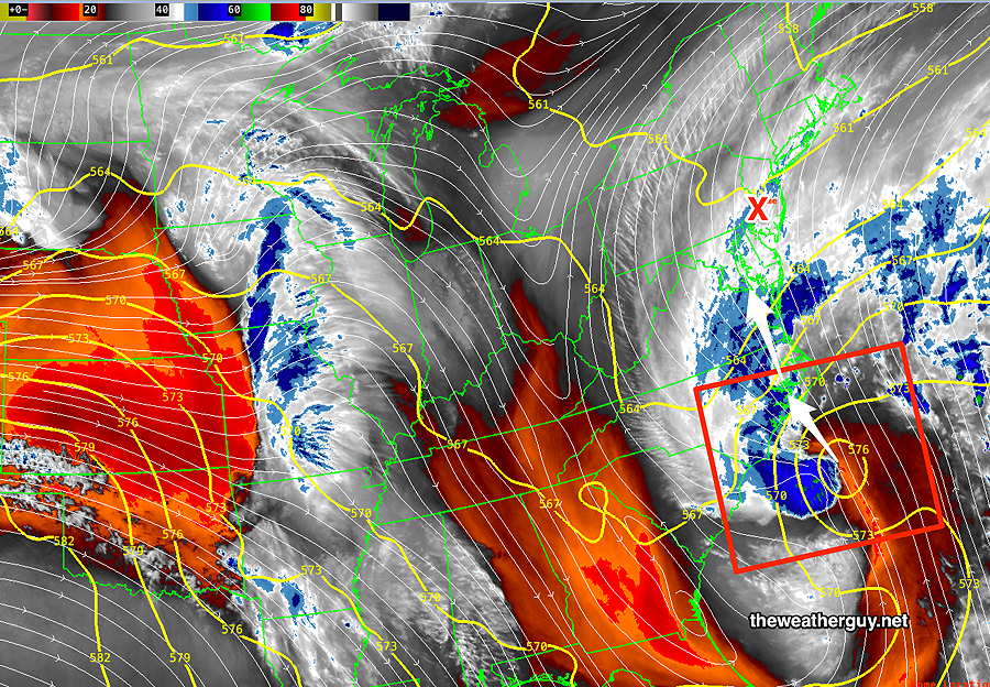
Here’s the current water vapor image of the storm—
Water Vapor image at 4:30 PM with superimposed jet level windstreams and 500-1000mb thickness (RAP Model). Notice the 576 thickness center with upper winds shearing off to the west (blue). (Click on image for a larger view.)
Ophelia is expected to move into North Carolina and become non-tropical (“extra-tropical”) this evening upon landfall. Due to blocking high pressure to our north, the movement of this system will be slow and it will affect our region with rain and high wind gusts for much of this weekend.
Rain should begin here between 1AM and 3 AM Saturday morning and will continue on and off through at least Sunday.
The latest (12) ECMWF is not all that impressive with rainfall here —
ECMWF rainfall through Monday 2 AM. (Click on image for a larger view.)
The NBM rainfall for just for Saturday (from now through 2AM Sunday) is below—
This afternoon’s 18z NBM accumulated rainfall through 2 AM Sunday. (Click on image for a larger view.)