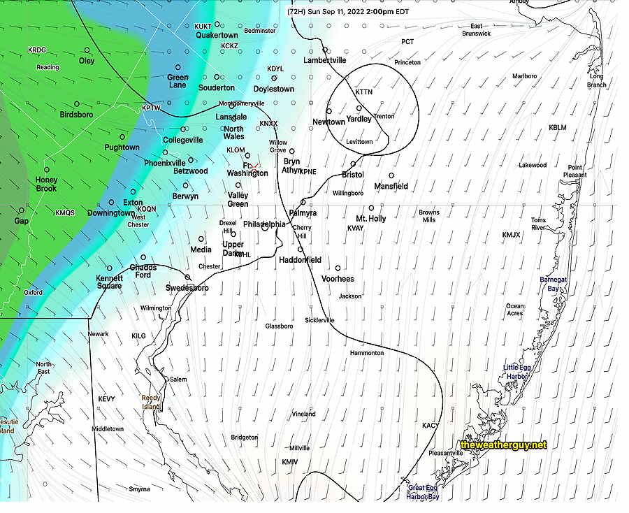
Updated Thu 9/08 8:32 PM —Well, after looking over some other models, the ECMWF and the GFS may be too fast with the rain moving in Sunday afternoon. The Canadian and German ICON models keep the rain in central Pennsylvania for much of Sunday afternoon and the latest model blend (NBM) leans towards that forecast. Will have to wait for clarification.
Update Thu 09/08 @ 7:42 PM — A significant change in the forecast for Sunday. While I had thought much of the weekend would be very nice, it appears that clouds move in earlier on Sunday morning with rain possible by early to mid late afternoon, especially areas just of west of the city.
The rain for Sunday afternoon is forecast, especially west of Philadelphia, by the GFS, NAM and ECMWF models.
Today’s 18z GFS shows light rain just moving in about 1 PM on Sunday. The ECMWF has the rain a little further eastward. (Click on image for a larger view.)
There may be a break in the action following this initial wave of showers, with rain returning by evening.
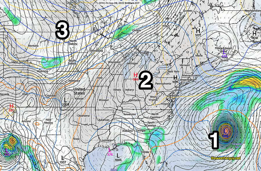
Update Thu 09/08 @ 9:38 AM —The next several days, through much of the weekend, will be very nice weather-wise. There’s the chance of some increasing cloudiness on Sunday.
The forecast is summarized in the GEFS graphic caption below—
Latest GEFS forecast for Friday at 5 AM. The low pressure system that brought us the much needed rain will merge with a (1) hurricane in the Atlantic. High pressure (2) will move in for Thursday through Sunday. A developing trough (3) will bring the chance of increasing cloudiness on Sunday and showers and rain Monday and Tuesday of next week. (Click on image for a larger view.)
Temperatures will be in the low to mid 80s which is slightly above the average seasonal highs of 78-79º.
With two hurricanes in the hemisphere, weather systems don’t always behave as forecast.
Showers continue on Wednesday
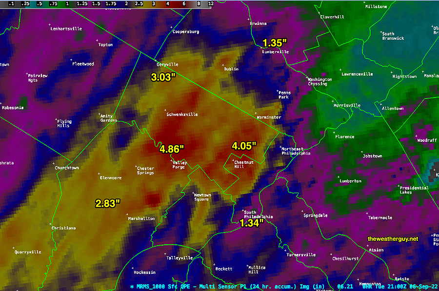
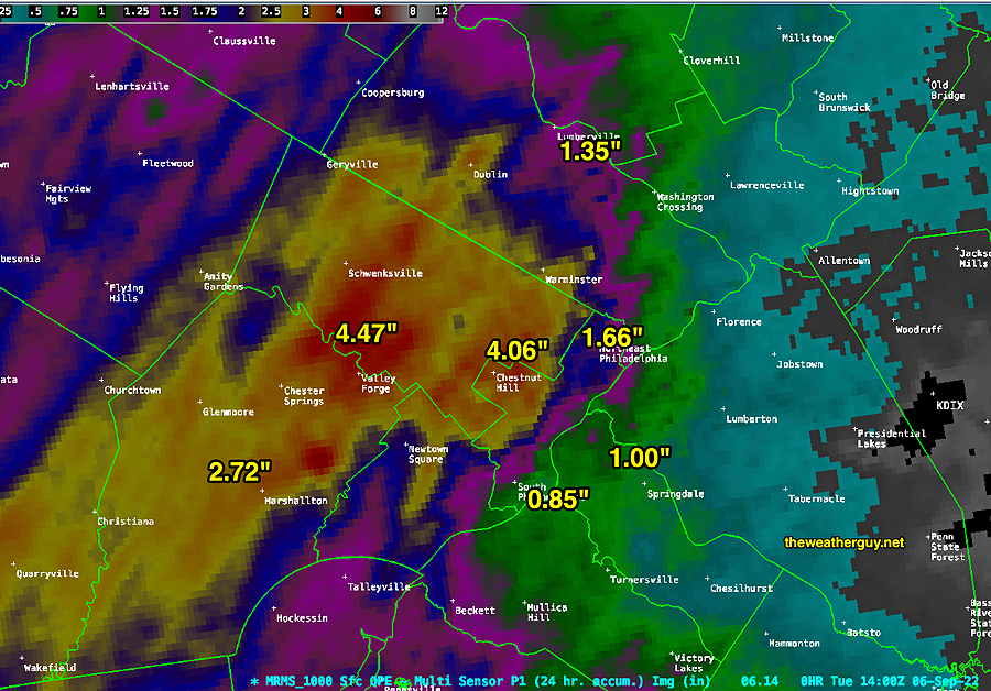
Update Tue 09/06 @ 5:58 PM — Here’s the latest MRMS rainfall totals for the past 24 hours—
MRMS rainfall totals for the past 24 hours as of 5 PM Tuesday. (Click on image for a larger view.)
Showers are expected to continue to move into the area from the northeast, as a circulation develops around the coastal low that is forming. These showers will linger through Wednesday.
The low pressure system will interact with a tropical system in the Atlantic. How this plays out will be difficult for the models to accurately capture, so I expect forecasts over the next day or so to remain a bit less reliable than usual.
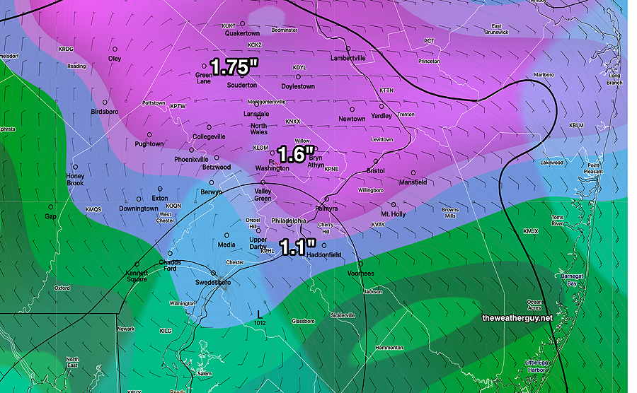
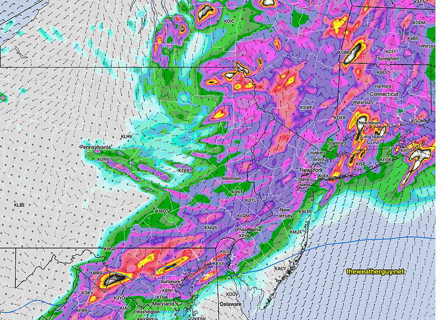
The latest (12z) ECMWF model forecast for Wednesday shows some considerable additional rainfall for our area—
Today’s 12z ECMWF model forecast for 2 PM Wednesday showing 3 hour precipitation. (Click on image for a larger view.)
Rainfall has already exceeded model forecasts
Update Tue 09/06 @ 11:22 AM — Here are the rainfall totals as of 10 AM according to the MRMS—
MRMS rainfall totals as of 10 AM Tuesday. (MRMS totals are always 1 hour lagged.) (Click on image for a larger view.)
Update Tue 09/06 @ 9:43 AM — Rainfall has already exceeded model estimates in many areas. Totals area already over 3 inches in Valley Forge and surrounding areas.
Rainfall rates should start to taper down about 3 PM, but additional showers are expected to rotate into the area from the northeast as low pressure develops off of the coastline.
I’ll update with an MRMS graphic of accumulated rainfall a bit later.
Update Mon 09/05 @ 6:04 PM — Heavy rain still on track later tonight through Tuesday.
Radar at 6 PM Monday. Rain has moved in somewhat faster and further east than forecast earlier today. (Click on image for a larger view.)
Latest GFS is still forecasting overall 1-3 inches by Tuesday afternoon.
Monday 18z GFS just available. Heavy rain totals by 2 PM Tuesday. Additional rains expected through Tuesday night and possibly Wednesday at times.
Monday – No rain for most of us. HEAVY RAIN Tuesday
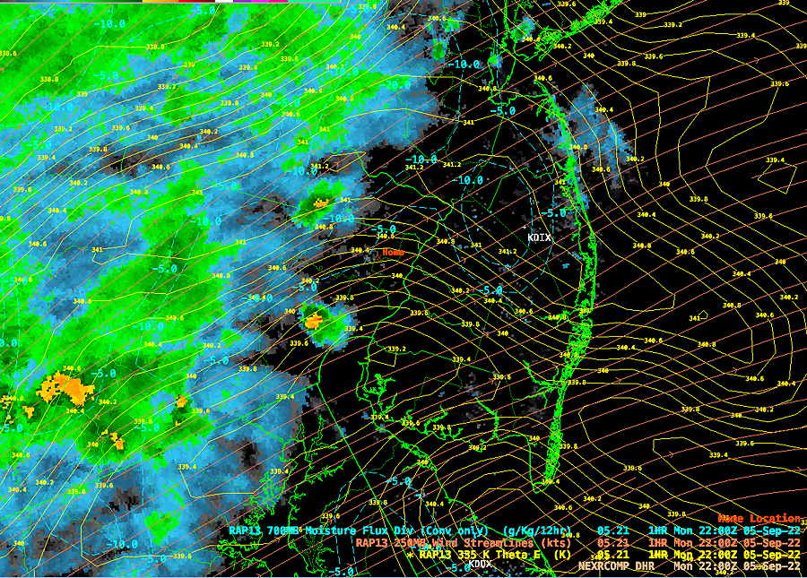
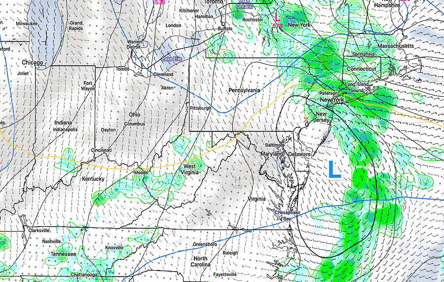
Update Mon 09/05 @ 8:50 AM— The same system that has been stationary for several days will being to move eastward later today.
Water Vapor image with with RAP model jet stream level 250 mb winds (orange contours), radar superimposed. Yellow contours are theta-E 335 contours, changes in potential energy. Cold front in Ohio will slowly move east with surface low (L blue) Upper air Low (L RED) hanging back in Lake Michigan. (Click on image for a larger view.)
The push of this system eastward will bring rain.
Much needed rain continues to be forecast for late Monday through Tuesday. Several models now have total precipitation forecasts 2-3 inch range, in line with the NBM and ECMWF forecasts from yesterday. Even the Canadian model has joined the group forecasting high precipitation.
While a few widely scattered showers are forecast towards evening today, most models have the bulk of the rain starting late evening or after midnight in the immediate PHL area (with somewhat earlier starts in upper Montgomery and Bucks counties).
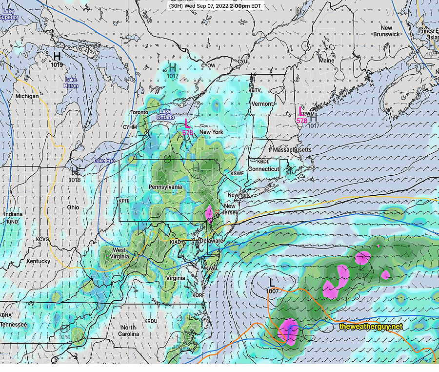
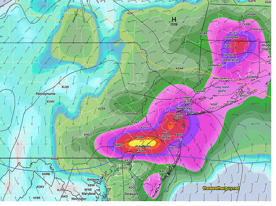
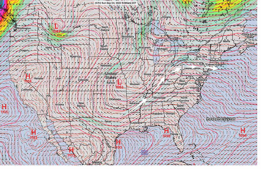
By Wednesday, the low will set up along the east coast, keeping unsettled weather at the shore—
RAP model forecast for 8 AM Wednesday. (Click on image for a larger view.)
Previously Posted Sun 5:33 PM —
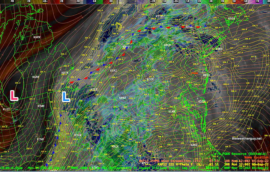
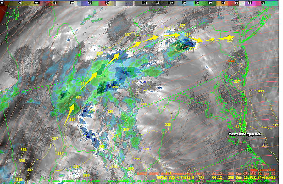
A front has remained stalled with associated rain moving around and at a distance from us—
Water Vapor with superimposed radar. Yellow arrows show the trajectory of the rain around but at a distance from our area. The entire system will move over us late Monday into Tuesday with heavy rain being forecast. (Click on image for a larger view.)
The whole system begins to move eastward and southward over our area Monday night.
We should have another dry day Monday but it will be much more cloudy than past days. Some showers may move into upper Montgomery and Bucks counties by late Monday afternoon and evening.
Heavy rain moves in during Monday night and continues into Tuesday. The ECMWF is forecasting as much as 3 inches of rain over Philadelphia! The NBM is forecasting 2.5 inches, with other models showing at least 1 inch of rain.
Update Sun 09/04 @ 7:36 PM — The latest NAM-NEST, ICON and Canadian GEM has the heaviest rain to our far north with our area getting about 0.6-0.8 inches of rain.
Update Sat 09/03 @ 5:49 PM — The forecast posted Friday still looks good. It does appear that we’re going to luck out: no rain in the immediate PHL area (and the shore) until late afternoon on Monday.
Current weather at 6 PM—
Water Vapor with jet stream level wind streamlines (orange streamlines) with superimposed radar. Moisture and rain flow will move north of our area through Monday. (Click on image for a larger view.)
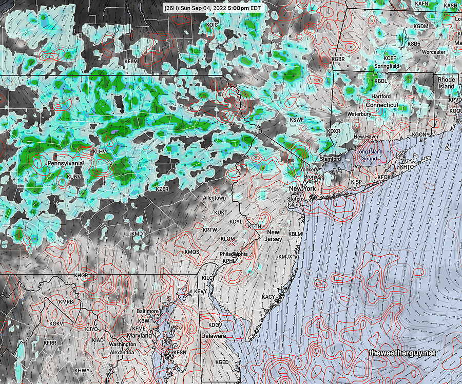
Sunday afternoon has the showers circling up around the region. We stay mostly sunny through high clouds and dry—
NBM forecast for Sunday 5 PM. Cloud cover is in grey/black. Red contours are spread uncertainty in cloud cover. Rain is green. (Click on image for a larger view.)
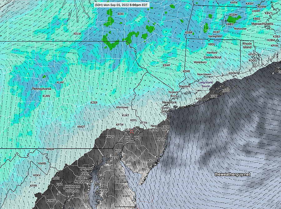
For Monday, the rain gradually moves in from the north and west. We’ll have significant cloudiness ,thickening during the afternoon, with rain by 5 PM, according to the latest NBM—
NBM forecast for Monday 5 PM rain moves down from the northwest. (Click on image for a larger view.)
Hard to believe, but the NBM cranks out a widespread rainfall of about 1 inch through Tuesday.
Updated Fri09/02 @ 11:35 PM — The forecast below remains on target.
Updated Fri 09/02 @ 5:45 PM —Not much change in the forecast (see the earlier “outlook” below). The system moving towards us may be even slower to arrive, which means Saturday and Sunday will be dry.
Indeed, the areas from just west of Philadelphia and eastward which have seen the least rainfall in recent months, will continue to be bypassed by any showers.
Saturday
High thin clouds much of the day; occasional periods of more signficant cloudiness. Dry. (There may be some afternoon showers along the NJ, coast according to the latest NAM-NEST.)
High temperature 86.4º (sd 1.3º) NBM model Blue Bell, PA
Sunday
Cloudy early morning, then sunshine by noontime. Increasing cloudiness again later in the afternoon and towards evening. Dry.
High temperature 87.9º (sd 3.2º) NBM model Blue Bell, PA
Monday
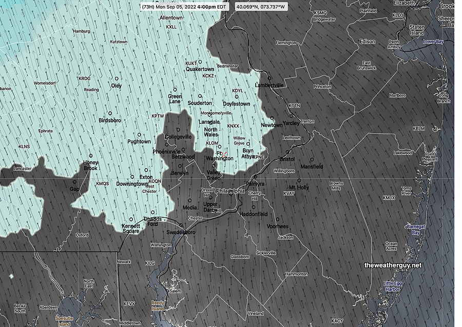
Considerably more cloudiness. Some models keep us dry while others have light rain moving in late afternoon or evening. (There’s significant uncertainty with Monday’s forecast.)
NBM Forecast Monday 4 PM. Light showers northwest, cloudy elsewhere. (Click on image for a larger view.)
High temperature 83.2º (sd 3.1º) NBM model Blue Bell, PA
Early Labor Day Weekend Outlook
Previously Posted Fri 10:13 AM —
A weak jet flow will result in slow movement of weather systems into our area.
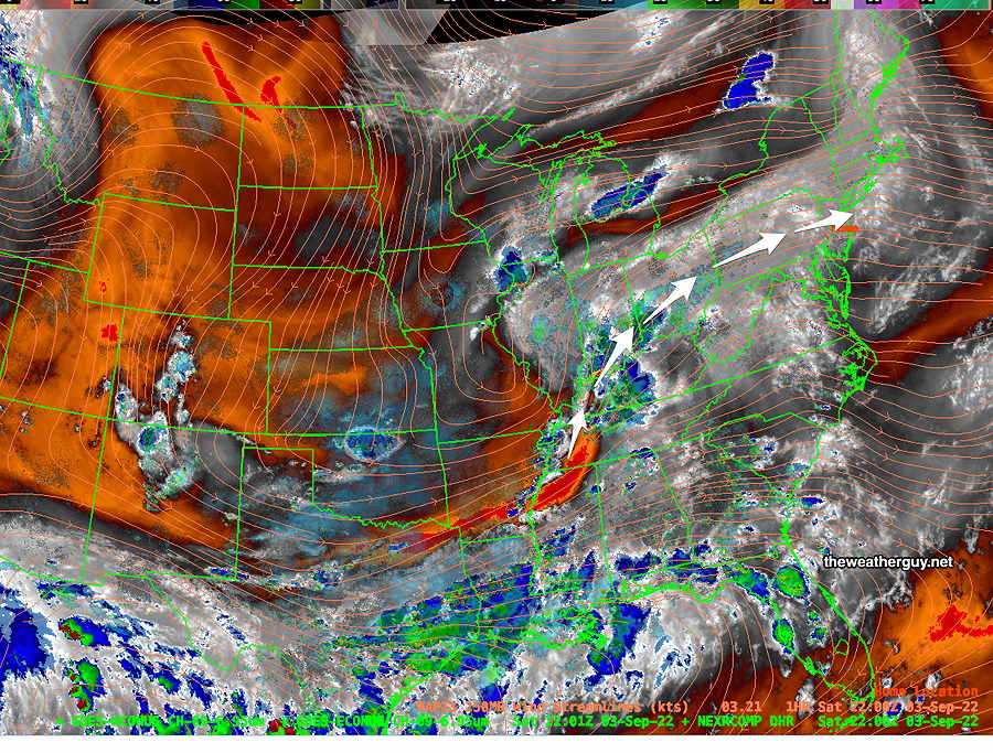
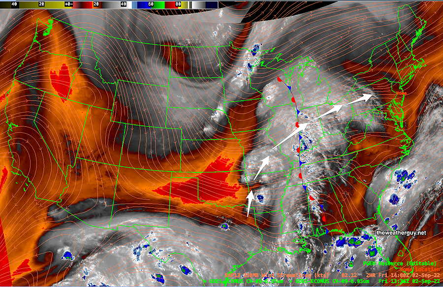
A somewhat stationary area of moisture in the Mississippi valley will slowly approach over the weekend. Here’s what it looks like Friday morning on satellite water vapor imagery—
Current water vapor image (Friday morning) with stalled stationary front This area of moisture will very slowly move eastward bringing an increasing chance of showers late Sunday and Monday. (Click on image for a larger view.)
The current upper air (jet stream level) map shows a somewhat stationary area of low pressure that will linger out west due to weak jet winds—
ECMWF jet stream level wind forecast for Sunday at 5 AM. Low pressure in the middle of the country with upper winds bringing moisture up from the Gulf of Mexico. (Click on image for a larger view.)
With systems moving so slowly (note the colored, higher speed winds can only be seen in the northwest corner and northeast corners of the map) the upper level low pressure system in Kansas will linger as moisture streams up over our area.
Based on the GFS and ECMWF, we’ll have mostly high cloudiness on Saturday and Sunday. Timing any showers precisely will be difficult. With continuing drought conditions, I expect any showers to stay mostly west of Philadelphia through most of Sunday.
There’s a hurricane in the North Atlantic. From experience, tropical systems with weak steering currents play havoc with forecasts even if they are many hundreds of miles away. I expect forecasts to change over the next few days, likely leaning towards even better weather.
According to the ECMWF, even Monday will be mostly rain-free—
ECMWF forecast for 2 PM Monday. Tropical system in North Atlantic. Rain hangs back into western Pennsylvania. (Click on image for a larger view.)
Updates later today and during the weekend. Stay tuned.