Update Fri 09/23 @ 9:37 AM — High pressure will build in Friday and be with us through Saturday. Low pressure near the Great Lakes will move eastward on Sunday.
Beautiful weather for Saturday.
Sunday looks to be mostly cloudy in the morning becoming cloudy by late morning. There’s a chance of some light scattered showers as early as 4 PM, but most models have the showers/rain waiting until evening.
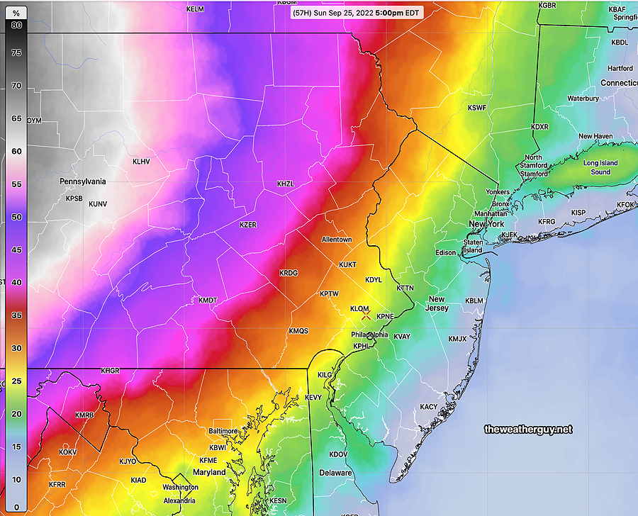
The uncertainty is best shown as a rain probability for Sunday at 5 PM —
Tooday’s latest 12zNBM 1 hour rain probability at 5 PM Sunday. Anything greater than 20% (green–>yellow) in a is a reasonable chance of rain in a 1 hour time frame. (Click on image for a larger view.)
My regular Weekend Weather Forecast will be posted later this afternoon.
Updated Thu 9/22 6:41 PM — Latest GFS has a change in the forecast for the weekend. Originally, the entire weekend was going to be quite nice. It appears that a warm front will bring some showers and clouds on Sunday. More info tomorrow.
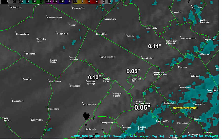
Models over-forecast the rain
Update Thu 09/22 @ 6:17 PM — The models over-predicted the amount of rain here today.
Here’s what actually fell, according the the MRMS—
Total Rainfall on Thursday based on the MRMS. A few areas (blue shading) had about 0.35 inches. Most did not. (Click on image for a larger view.)
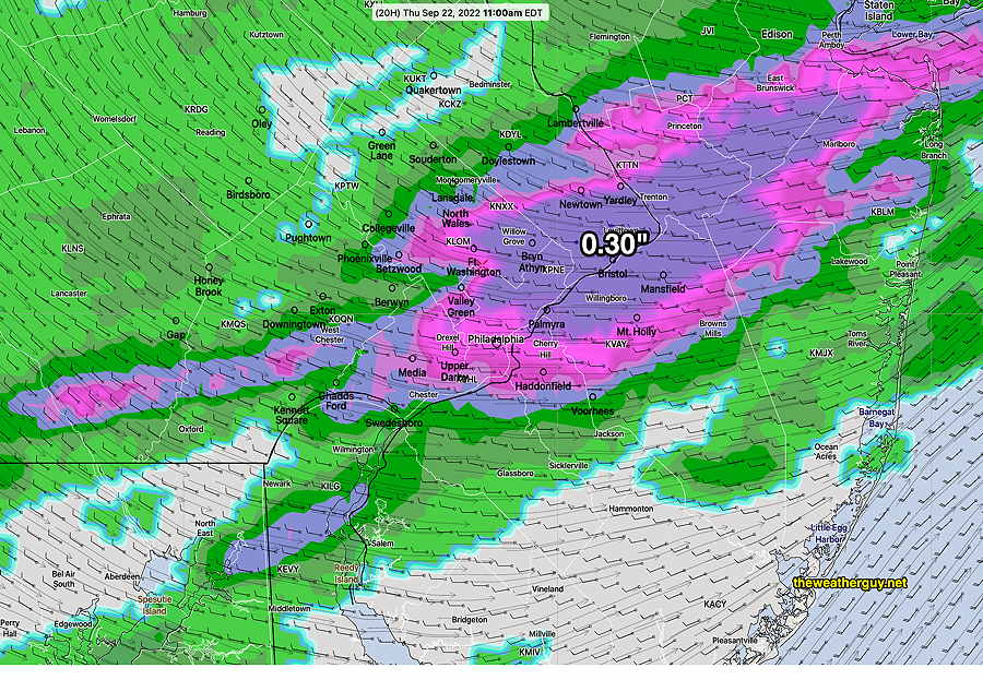
Some Rain mid-day Thursday
Update Wed 09/21 @ 7:57 PM — Latest models are fairly consistent with previous forecasts. Rain, maybe even a thundershower, beginning mid to late morning Thursday and ending in the 1 PM-3 PM time frame.
Maximum total precipitation, according to the NBM, is about 0.1-0.3 inches of water—
Today’s 19z NBM forecast for Thursday at 11 PM (precipitation and winds) (Click on image for a larger view.)
Friday, windy and autumnal. The weekend looks very nice!
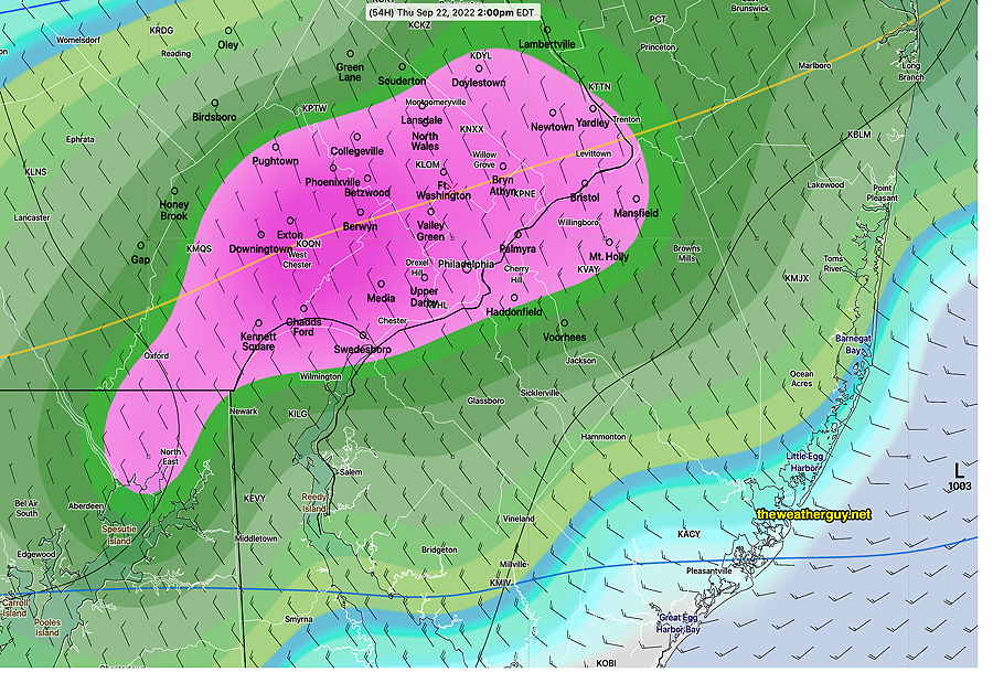
Update Tue 09/20 @ 8:29 PM — The strong cold front mentioned over the weekend is expected to move through the immediate PHL area Thursday from late morning into early afternoon.
All models have some rain for our area, but the range is anywhere from 0.2 inches to about 0.7 inches.
Today’s 12z ECMWF rain forecast (3 hour accumulation) at 2 PM Thursday. Pink-Purple is about 0.7 inches. (Click on image for a larger view.)
The German ICON is similar to the ECMWF, but the US models (GFS, NAM-NEST) only crank out about 0.2-0.3 inches rain, keeping most of the rain to our north.
The Canadian HRDPS is the least aggressive with the rain in our area, keeping most to our north and amounts less than 0.1 inches.
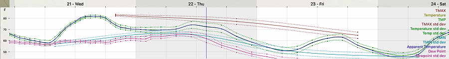
It will get very windy with the frontal passage and gusty winds are expected Friday. High temperatures on Friday only in the lower to mid 60s (Blue Bell, PA)
NBM Temperature forecast Wed through early Saturday. (Click on image for a larger view.)
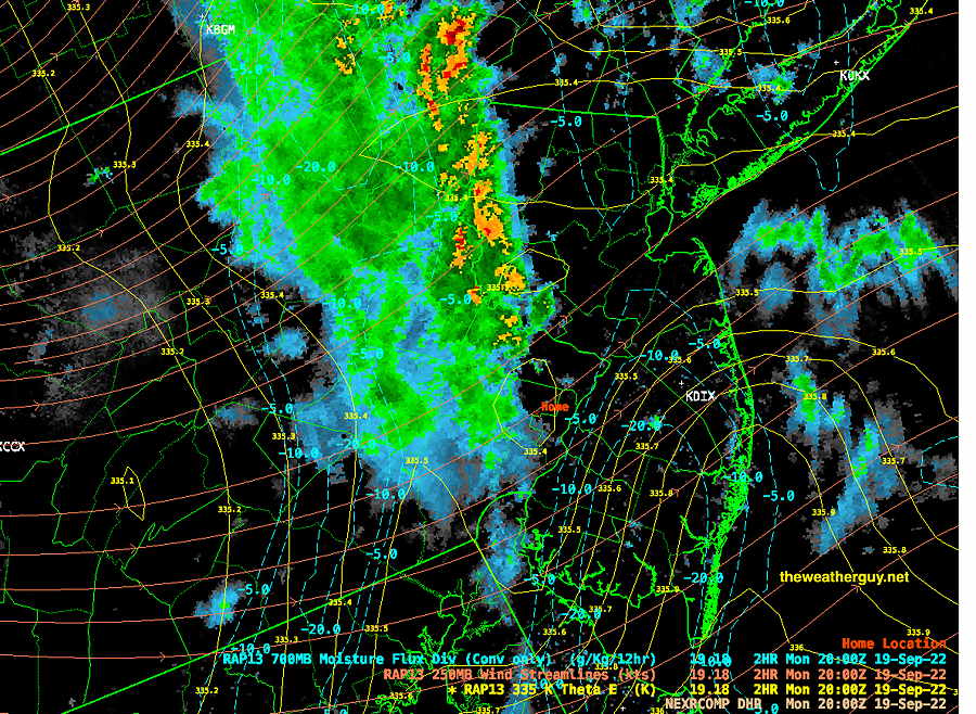
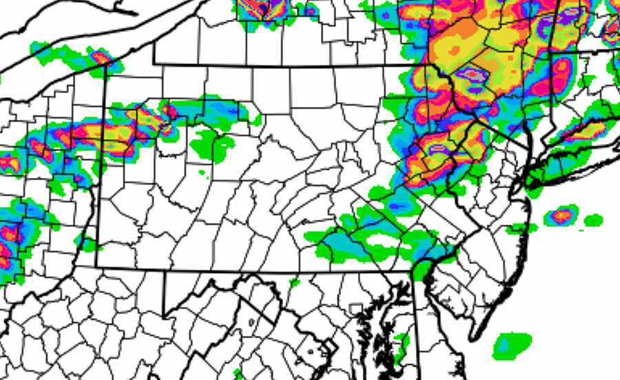
Update Mon 09/19 @ 4:12 PM — So the showers associated with the front arrived around 4 PM, as forecast by the HIRESW. But with a bit more rain than had been forecast—
4 PM Hybrid Radar with superimposed RAP 250 mb wind flow, moisture convergence and isentropic levels. (Click on image for a larger view.)
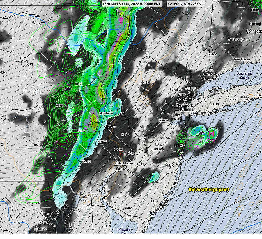
I’m always interested in which, if any ,model got this forecast right. The NAM-NEST didn’t. Best performance this time around goes to the Canadian HRDPS—
Today’s 12z Canadian HRDPS precip and cloud forecast at 4 PM (Click on image for a larger view.)
Unfortunately, there is no single good model for every forecast scenario. Ever since the HRDPS was updated back in Dec ’21, it has done farily well with frontal passages. Unfortunately it takes the CMC significant time to compute the model and downloading it with post-processing at my end keeps me from seeing it until 6-7 hours after each model run.
Previously Posted Mon 1:22 PM —
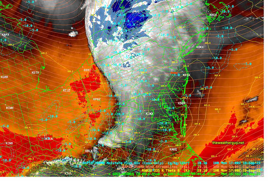
A weak front moving through western Pennsylvania Monday morning will move through our area between 6 and 8 PM.
Water Vapor image at 1 PM showing front in western PA. Most of the dynamics (blue) are north of our area. (Click on image for a larger view.)
Most of the dynamics and energy with this front will shear off to the far north and west.
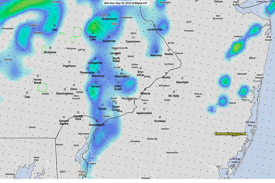
The high resolution models are showing some showers moving into far northern and western areas, but then weakening considerably as they move into Philadelphia between 4 PM and 7 PM. Nothing expected for the Eagles game.
High resolution HIRESW-ARW model (2.5 km resolution) at 4 PM forecasts a few radar echos.
The experimental LAMDAX model has even less precipitation at 6 PM—
Experimental LAMDAX model forecast for 6 PM Monday. The color codes are different; total rainfall amounts falling is on the order of a few hundredths of an inch. (Click on image for a larger view.)
As mentioned in my previous posting, an interesting, very strong cold front moves through sometime in the Thursday time frame. A quick taste of much cooler temperatures for Friday and the weekend. Exact timing of that front uncertain at this time.
Some thunderstorms are possible, but total rainfall is looking generally low.