Forecast Review— The line of storms weakened considerably, as they entered Philadelphia, as forecast. A good example of how upper airanticyclonic curvature can suppress storms even with very high CAPE and high instability in the lower atmosphere.
Updated Sun 5:53 PM — The line of storms just to our west is supposed to weaken just as reaches Philadelphia, but the southern part of the line is forecast to continue to move east. We’ll see if this happens. (The models haven’t been too good today.)
Update Sun @ 10:25 AM — Models still showing possibility of localized showers around noontime/early afternoon in the northwest corner area of Philadelphia. The new NBM still shows a temp of 90-91º but also shows scattered showers around the area during the afternoon.
Updated Sun 8:22 AM — Changes in the forecast: Looking at the 2 AM runs (06z) of the NAM and the 09z run of the RAP model shows much more in the way of showers today than had been forecast with last night’s earlier (00z) models.
As a result, high temperatures of greater than 90º look much less likely. (There were hints of these changes with last night’s 00z models.)
The main group of showers/storms are still forecast to move through about 7-9 PM tonight, but I’ll update based on the new models available later this morning.
Updated Sun 7:44 AM — The upper air disturbance has already caused showers to break out just west of Philadelphia this morning.
Updated Sat 9:43 PM — Some forecast changes for Sunday. High temperatures 91/92 (Blue Bell/Philadelphia), although some models have us just making it to 90°.
There’s uncertainty about the timing of thunderstorms, with the RAP showing some early, widely scattered activity around noon/early afternoon, then joins the other models with more storms between 6 and 9 PM. (The early activity due to an upper air vorticity.)
Current forecasts have most of the activity north and west of the city with storms weakening as they move towards Philadelphia, then much remaining activity slipping by to our south.
Forecast Review— We didn’t set a record high today. With yesterday’s NBM forecasting 96.1° with a sd of 2.4°, PHL’s high of 95 was within that range. (Actually, this morning’s NBM had reduced the expected high to 95°.)
Previously Posted Fri 8:31 PM —
A southwesterly flow of very hot air will move into our area over the weekend.
GFS forecast 8 PM Saturday. Jet stream (white arrows) north of our area with southwesterly flow (Red arrow). Despite significant moisture moving up from the Gulf, we will be hot and dry Saturday. Thunderstorms late afternoon/early evening Sunday look likely. (Click on image for a larger view.)
Saturday
Near record setting heat expected. Mostly sunny hot and fairly humid.
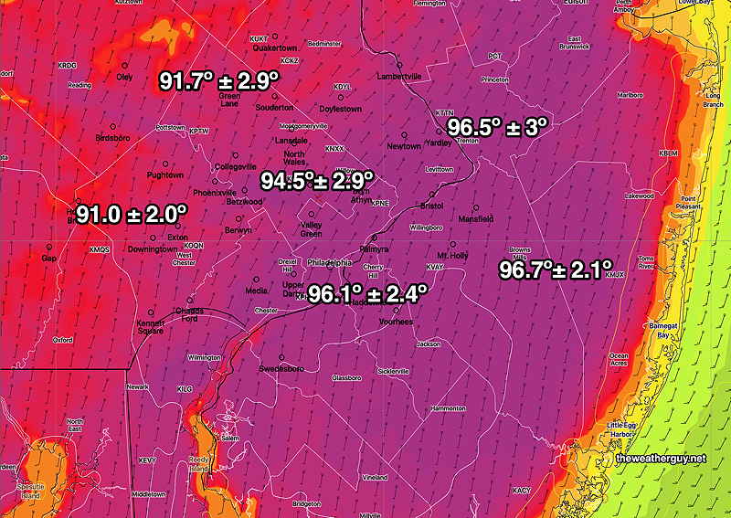
NBM model forecast high temperatures with standard deviation. (Click on image for a larger view.)
Sunday
Continued hot. High temperatures run about 2-3 degrees ‘cooler’ than Saturday. A cold front sinks south towards us during the day. Thunderstorms likely after 5 PM.