Wed 09:30 AM Forecast Review — Temperatures started a little warmer than forecast, but dynamic cooling from a high precipitation rate has caused the rain to mix with snow here. So the forecast looks on track.
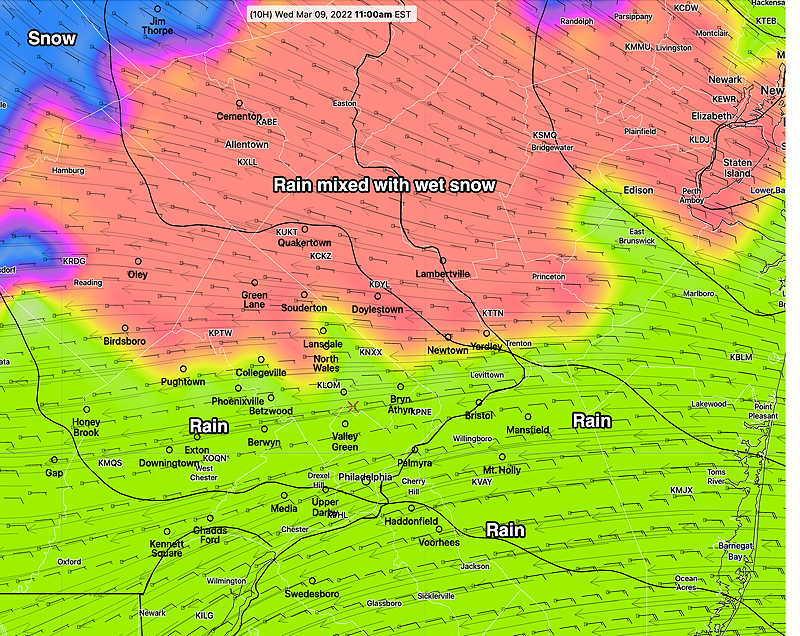
Latest CMC-RGEM Precipitation Type forecast for 11 AM—
CMC-RGEM Precipitation Type Forecast at 11 AM (Click on image for a larger view.)
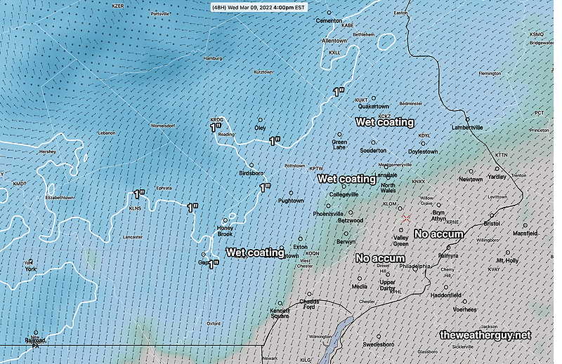
Update Tue @ 11:16 PM — Tonight’s models are coming in a bit colder. Rain, mixed with periods of sleet and wet snow, possible. Most of the area will have no accumulation, but a coating to about a half an inch accumulation in upper Montgomery and Bucks counties, according to tonight’s RGEM.
Update Tue @ 6:18 PM — This afternoon’s models continue with the forecast of precipitation beginning about 5-6 AM as rain mixed with wet snow, then changing to all rain by 8-10 AM for most of the area. No accumulation expected for most of the area. Essentially a rainy day.
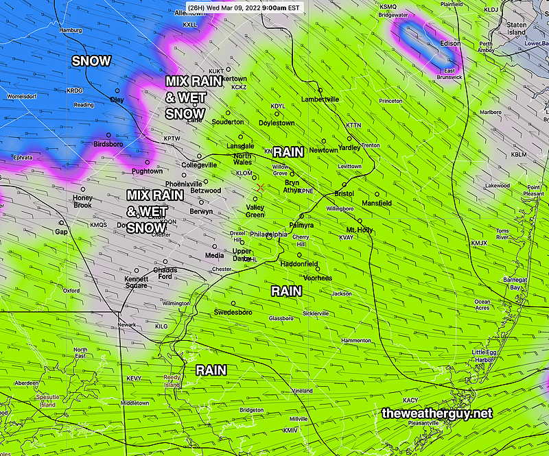
Update Tue @ 11:44 AM — This morning’s Canadian RGEM has consistently shown Wednesday’s storm to be mostly rain in most of our area, but with wet snow mixed in at start. No accumulation expected here.
This morning’s RGEM showing mostly rain with some mix possible Wednesday 9 AM. (Click on image for a larger view.)
Of greater interest is the large coastal storm expected Saturday. Stay tuned.
Update Tue @ 7:55 AM — Last night’s GFS and Canadian RGEM show virtually no snow accumulation on Wednesday in the Philadelphia area, except for the far northern and western suburbs. While temperatures just above 2000 feet will be cold enough for snow (at times) during the day, overall thermal profiles don’t support snow accumulation. The RGEM is even warmer with mostly rain falling.
High precipitation rates may cause dynamic cooling, enough to allow some of the precip to fall as snow at times, but it will melt on the surface and certainly any roadways.
I’ll keep an eye on it.
Update Mon @ 8:12 PM — So, I’ve been asleep at the wheel regarding Wednesday’s storm… I took a quick look at the forecast, saw the critical thickness line (red line) was north of our area, forecast rain, and I never looked further. But there’s more to this.
I haven’t watched the TV weather in a long time, but I could tell something must be brewing because I noticed a large uptick in my web traffic stats. So, I took a deeper look and I see that snow is possible for Wednesday. But is it really gonna happen?
Monday’s 21z NBM showing precipitation and critical 32º wet bulb temperatures (dark blue) and Bourgouin critical levels (yellow contour). (North of these contours, snow is possible.) We don’t see the 32º surface temperature anywhere on the map because it’s going to be 37º in our area, according to the NBM. (Click on image for a larger view.)
So, will it snow on Wednesday? Maybe wet snow or snow mixed with rain will fall. In favor of the snow are cold temperatures above 2000 feet and relatively high precipitation rate.
Will it accumulate?
I don’t think we’ll get accumulation in the immediate PHL area. We’re up against a March high sun angle and surface temps above freezing.
The NBM has this snow forecast—
NBM snow forecast by 4 PM Wednesday. (Click on image for a larger view.)
I’ll keep an eye on it.
Update Mon @ 6:17 PM — After this evening’s showers, the next storm to affect us will be on Wednesday. Easterly winds and rain expected—
Monday’s 12zGEFS forecast for Wednesday at 1 PM (Click on image for a larger view.)
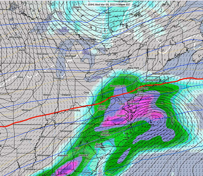
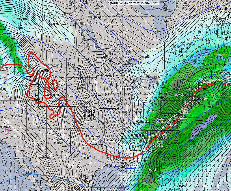
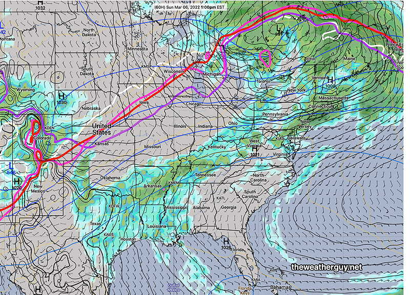
Of greater interest will be a major storm expected to develop on Friday night into Saturday. This has the makings of a significant coastal storm with snow in western Pennsylvania into parts of New England.
Monday 12z GEFS forecast for Saturday, 11 AM. A deep storm, possible bombogenesis. (Click on image for a larger view.)
While I’m leaning towards, the warmer GFS, the ECMWF shows possible changeover to snow for us. Not so sure about that.
Mon 06:05 PM Forecast Review — The high temperature reached 77º in PHL, but I don’t think surrounding areas were as warm as predicted. The showers came through about 4-5 PM on schedule, but with much lower intensity than expected. Additional showers before 10 PM.
Update Mon @ 9:29 AM — Today’s HRRR shows elevated CAPE northwest of Philadelphia between 4-6 PM as the rain moves in. This suggests the possibility of thunderstorms embedded in the first area of rain just northwest of the city.
Previously Posted Sun 9:45 PM —
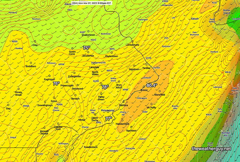
On Monday, high temperatures are expected to get to the upper 70s with a some areas possibly touching 80º. A cold front approaches with rain moving in from 4-5 PM. (Considerable cloudiness will limit what could have been even warmer temperatures.)
Today’s 18z Canadian RGEM high temperature forecast for Monday. The RGEM has been doing well with temperatures, but it is at the higher end compared to other models. (Click on image for a larger view.)
The unseasonably warm weather expected Monday will eventually give way to cold weather again over the coming weekend.
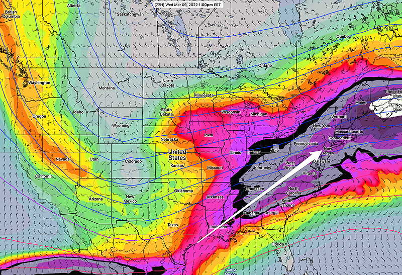
During this coming week, we’ll be transitioning from a ridge with a southwesterly flow to an eventual colder trough over the weekend.
GEFS upper air flow (jet stream level 250mb) on Wednesday at 1 PM. Southwesterly flow will bring moisture and several low pressure systems passing just to our south over the week. (Click on image for a larger view.)
Several low pressure systems are expected to form and move up from the southwest. After rain Monday night, we’ll likely see some rain again on Wednesday and yet again Friday into Saturday.
The strong contrast in temperatures is likely to set off some wild weather.
Saturday may have some “interesting weather” for us as a strong cold front moves through, according to the latest GEFS—
Today’s 18z GEFS forecast for Saturday 10AM. A strong cold front moves through with some snow possible in far northern areas. (Click on image for a larger view.)
Sun 09:46 PM Forecast Review —We had the showers and we saw some sun before clouds rolled in later. The afternoon’s second batch of showers moved mostly south of Philadelphia.
Update Sun @ 11:52 AM — This morning’s models continue the second batch of showers coming in between 4 and 6 PM. There may still be some breaks in the clouds with brief sun in some areas this afternoon. So, aside from the mild temperatures and the wind, today won’t have the perfectly sunny afternoon previously predicted.
This morning’s 12z HIRESW-ARW simulated radar and superimposed accumulated rain (green contours) forecast for 5 PM Sunday. Dark is cloud cover > 90% (Click on image for a larger view.)
Monday is continuing to look very warm! Here’s the Canadian RGEM which tends to do well with temperatures lately—
Sunday 12z CMC RGEM temperatures for Monday at 2 PM Orange contours are 1 degree increments (Click on image for a larger view.)
Updated Sunday forecast on Sun @ 8:48 AM — Last night’s models suggest a change in Sunday’s forecast— the morning showers may linger into the early afternoon and a second batch of showers may move in later in the afternoon. Showers may be with us until 3-5 PM. There still may be breaks of sun in the afternoon but a sharp transition to beautiful, warm day may not be in the cards for today.
Updated Sunday forecast on Sat @ 5:40 PM — It now appears that the showers will move out between 1 and 2 PM Sunday with sunshine in the afternoon. Warm and very WINDY
Saturday
A warm front will move through on Saturday with some cloudiness and a chance of light showers in the afternoon, as the upper air flow becomes southwesterly and an upper air ridge moves over the northeastern US.
Varying amounts of cloudiness and some bright spots/sun expected with more cloudiness in the morning. Clouds may break after 3-4 PM
No showers expected in the immediate PHL area. (possible, north of Doylestown.)
The latest Canadian RGEM and the NAM-NEST are more optimistic about bright skies and even periods of some sun mid-day on Saturday.
High 51.1º sd 1.1º NBM model, Blue Bell. High temperatures have been trending towards the upper end of the statistical spread (52º)
Previously Posted Fri 10:27 AM —
Sunday
A low pressure system moving through Canada will drag a weak surface front through on Sunday with showers.
Saturday morning’s 12z NAM-NEST showing 1 hour accumulated precipitation at 1 PM. (Click on image for a larger view.)
Cloudy in the morning with showers, ending about 2 PM. Heaviest rain northwest of the city.
Breaks of sunshine during the afternoon.
VERY WINDY — sustained winds 19 mph with gusts near 35 mph.
Unseasonably warm. High 70.3º sd 3.1º NBM Blue Bell. (Very large spread/uncertainty. Temperatures have been trending towards the upper end of the statistical spread (73-74º)
Monday Outlook
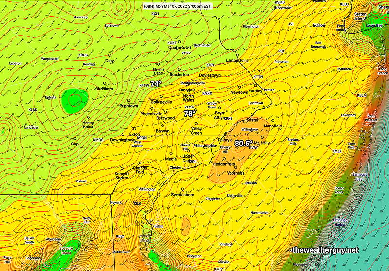
Forecast high temperatures for Monday according to the Canadian RGEM —
Saturday’s 12z Canadian RGEM model temp forecast with 2º increments at 3 PM Monday. The Canadian GEM does well with temperatures. (Click on image for a larger view.)
A warm front will move through on Saturday with some cloudiness and a chance of light showers in the afternoon, as the upper air flow becomes southwesterly and an upper air ridge moves over the northeastern US.
Varying amounts of cloudiness and some bright spots/sun expected with more cloudiness in the morning. Clouds may break after 3-4 PM
There’s a slight chance of very light scattered showers between 2 and 4 PM innorthern suburbs, according to the latest ECMWF. Most models show no precip in our area.
Update: The latest ECMWF model still has some light showers in the Philadelphia area 2-4 PM. Other models do not.
The latest Canadian RGEM and the NAM-NEST are more optimistic about bright skies and even periods of some sun mid-day on Saturday.
High 52.6º sd 1.8º NBM model, Blue Bell. Temperatures have been trending towards the upper end of the spread (54-55º)
Sunday
A low pressure system moving through Canada will drag a weak surface front through on Sunday with showers.
ECMWF forecast for 1 PM Sunday. Rain displayed is 3 hour prior accumulation. (Click on image for a larger view.)
Cloudy in the morning with showers, ending about 1 PM
Update: The ECMWF has showers lasting into early afternoon.
Heaviest showers north of the immediate PHL area.
Some breaks of sunshine during the afternoon.
VERY WINDY with gusts near 35 mph.
Unseasonably warm. High 70.7º sd 3.9º NBM Blue Bell. (Very large spread/uncertainty. Temperatures have been trending towards the upper end of the spread (~74º)