WEEKEND WEATHER FORECAST

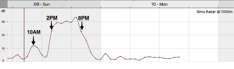
Update Sun @ 10:09 AM — On my way out at 10 AM but it’s raining!

NBM Simulated Radar meteogram posted two hours ago

What about this peak at 10 AM?? Hmmm….. I guess I didn’t annotate my own meteogram closely enough.

Same meteogram posted two hours ago, but with the early precipitation peak properly noted at 10 AM.

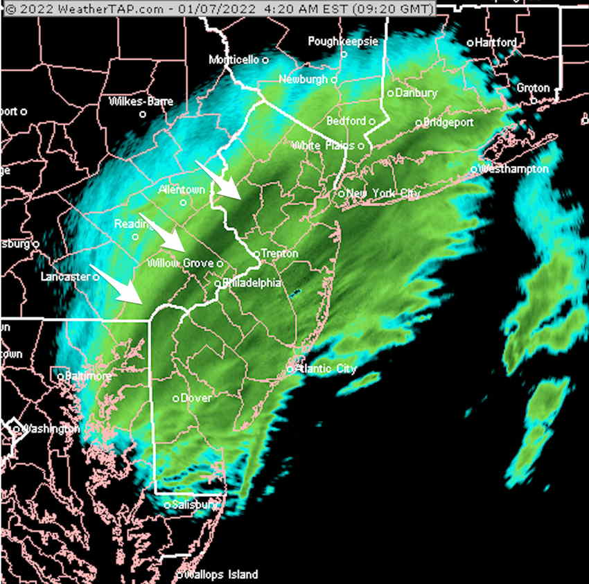
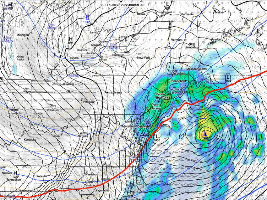
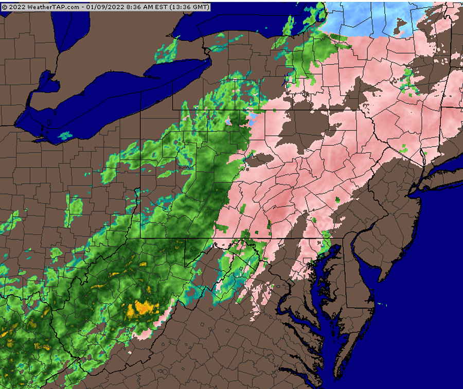
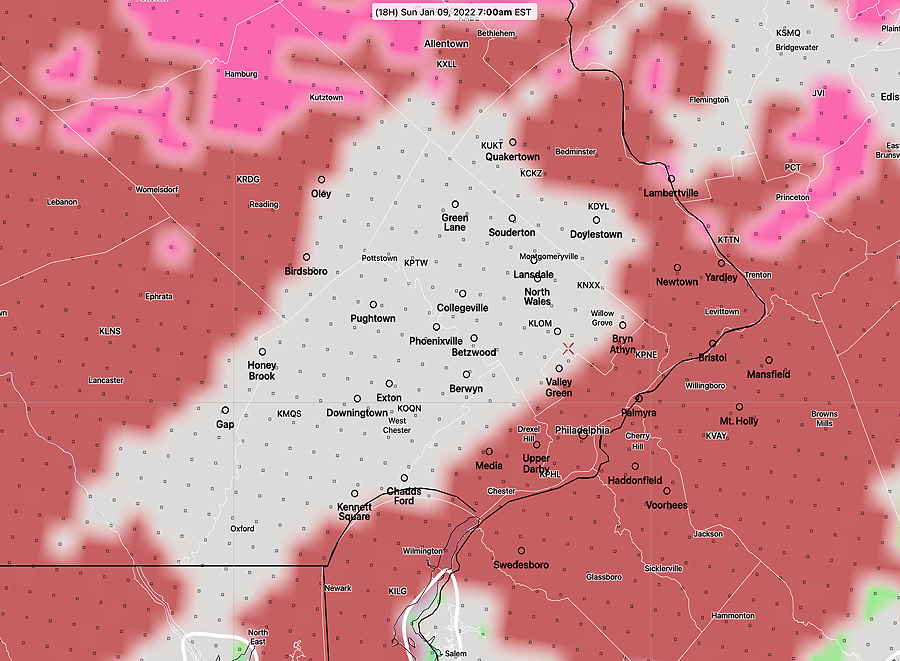
Update Sun @ 8:30 AM — As suspected, some of the high resolution models weren’t too great in forecasting the freezing rain. The GFS, NAM and NAM-NEST as well as the HIRESW-FV3 correctly forecast the precipitation at it’s current location—

Current RADAR @ 8:40 AM (courtesy of weathertap.com) (Click on image for a larger view.)

So when will it rain?

NBM radar meteogram (Blue Bell, PA) Rain starts about 1-2 PM and ends after 8 PM. (Click on image for a larger view.)

The models also show winds getting quite gusty by the time the rain starts.


Update Sat @ 11:03 PM

Tonight’s GFS looks a lot like the NAM and NAM-NEST with the freezing rain staying clear of our area in the morning and rain moving in about 1-2 PM.

Update Sat @ 9:45 PM — Eagles halftime and time for a weather update.
The trend with tonight’s models is for the early slug of potential freezing rain to stay just north and west of Philadelphia. The NAM group has any freezing rain not even close by. The newer models HRRR, RAP and and HIRESW models keep the freezing rain just north and west.

Only one version of the HIRESW-ARW has some light freezing rain in Philadelphia early.

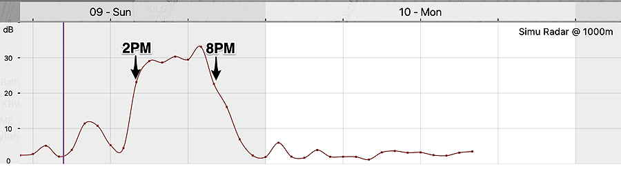
Of interest is that the morning may be relatively rain free after a quick slug of precipitation, with the main area of rain moving in about 1-3 PM.

HIRESW-FV3 forecast.

SREF forecast

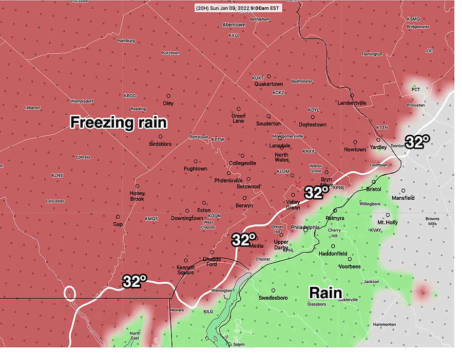
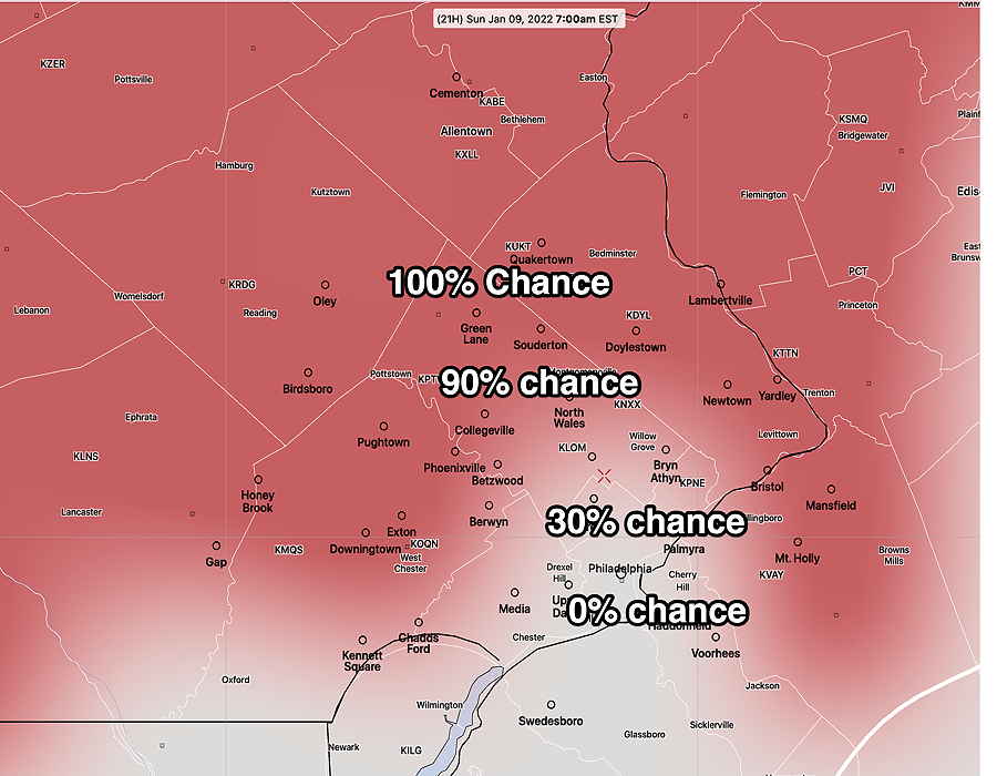
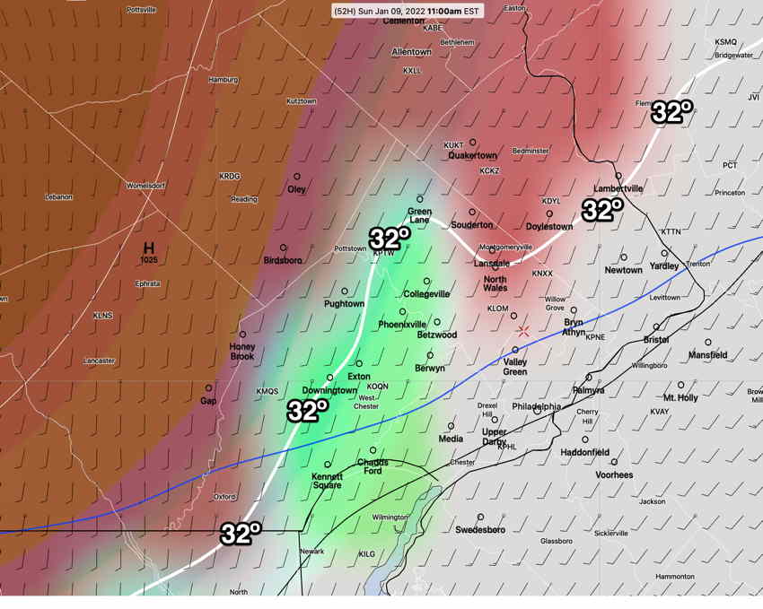
Update Sat @ 4:35 PM — Today’s models continue to increase the likelihood of a period of freezing rain on Sunday morning. While most of this will occur just north and west of Philadelphia, several models are showing very light freezing rain occurring around 7 AM within the city. It will changeover to rain from south to north, and by noon, and it should be all rain as far north as Quakertown.

HREF 18z model shows freezing rain (red) and some sleet (pink) throughout the area at 7 AM Sunday (Click on image for a larger view.)
HREF 18z model shows freezing rain (red) and some sleet (pink) throughout the area at 9 AM Sunday (Click on image for a larger view.)

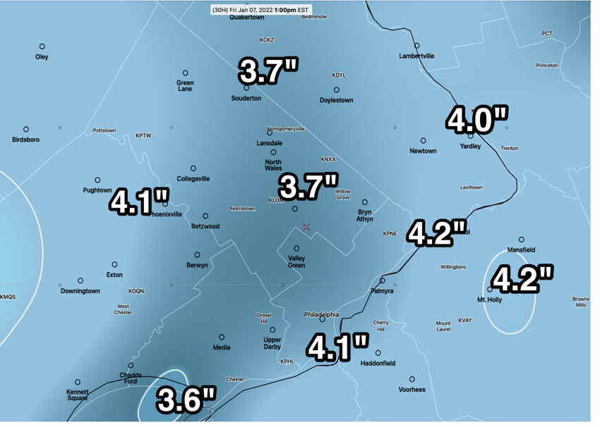
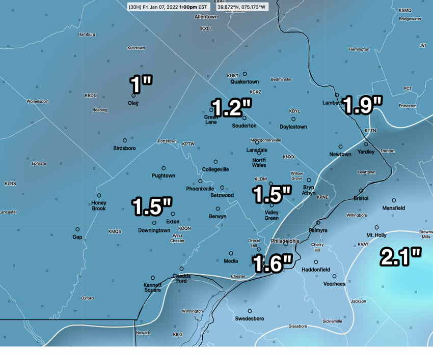
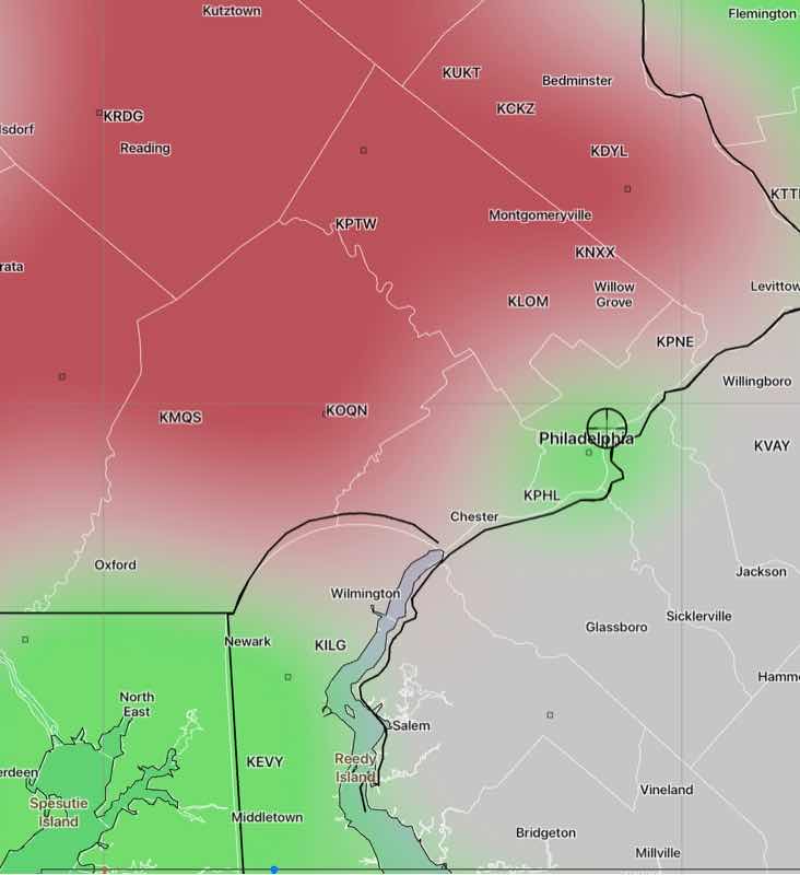
As shown in the graphic below, the lower resolution GFS is not as aggressive with the freezing rain in Philadelphia as the HREF model because it has the precipitation coming in somewhat later, after the temps have warmed up. (The latest Canadian RGEM model is similar to the GFS, with precipitation coming in later.)

GFS 18z freezing rain probability. (Click on image for a larger view.)

Update Sat 7:50 AM— Saturday high temp 29.3± 1.3º. (Somewhat colder). Sunday a period of freezing rain in the morning looking more likely at this time. Sunday details.


The weather moves to an active pattern as amplifications in the jet stream, both ridges and troughs, move through the northeastern US.

GEFS forecast for Saturday. An upper air trough (1) will bring cold weather. This will quickly be followed by an upper ridge (2) early Sunday before another trough (3) quickly moves in Sunday night. Very cold high pressure (4) will accentuate the trough over the northeastern US and extremely cold weather is expected Monday into Tuesday. The upper level see-saw continues next week but the trend is for much colder weather. (Click on image for a larger view.)

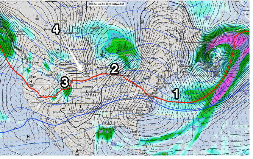
The expected pattern is described in the caption above.

Saturday

Saturday will be sunny and cold but winds should subside as a surface high will be right over us. High temp 32º ± 2º NBM Blue Bell

Sunday

The upper ridge moves over us and surface winds become southerly, bringing some moisture. The moisture will rise over cold air and a period of freezing rain is possible northern and western areas during the mid to late morning. This should all change to plain rain in the immediate suburbs, but very far northern/western areas (north of Allentown) might see a prolonged period of freezing rain . High temp 42º ± 3º (NBM Blue Bell)

GFS model forecast for 11 AM Sunday. Areas of freezing rain in red/orange areas. Green = rain. It should all changeover to rain during the afternoon. (Click on image for a larger view.)

Light rain through the afternoon. Winds pickup and become gusty later afternoon into evening.

A cold front moves through before midnight Sunday with gusty winds. Temperatures drop into the 20s with lower wind chills.

Very cold weather Monday through Tuesday.

WINTER WEATHER FORECAST

Fri 6:40 AM Forecast Review — Well, we have 5 inches of snow at 6 AM in my neck of the woods, higher than predicted by any model.

When I briefly woke during the middle of the night and looked out the window, I saw that my over-reliance on last night’s NAM was misguided.  As I fell back to sleep, I remembered another forecasting concept called “model spin up”.  

I realized that the low snow model forecast from the latest 00z models were for  a weather event that had already begun in our area.  Not allowing for “model spin up time” was one reason the NAM and GFS 00z models had suddenly lowered their snow totals for this storm in our area.  

Basically, it is known (and sometimes forgotten) that the latest model isn’t always the best version for a large scale weather event in progress, as it doesn’t allow the computational state of a model to develop.  The time needed is called model “spin up” time and is often a few hours.   (True for large scale weather events, not always true for mesoscale events like thunderstorms.)

That’s why yesterday’s afternoon models (3-4 inches) were closer to the actual snow totals.  However, additional mesoscale banding occurred, allowing even higher snow totals. Placement of mesoscale banding is very difficult to predict in advance.    

Some of the accumulation on streets and sidewalks are closer to the forecast range, probably because of some melting/compaction; actual ground surface temperatures have been quite warm for weeks. 

Always a learning experience. I guess I need to add “model spin up” to my mantra. 

MRMS Accumulated Precipitation with 10:1 snow ratio. Since the HRRR indicated water-snow ratios of 12:1 at times, actual amounts may be somewhat higher.  (Click on image for a larger view.)


Official snow totals at this link.

NEXRAD radar image showing banding that developed 4:20 AM  (Click on image for a larger view.)


Update Thu @ 10:56 PM — Tonight’s GFS has its snow totals lower than previous runs and has moved in the direction of the NAM. Tonight’s ICON has also has lower accumulations. I would go with the NAM forecast graphic just below, perhaps adding 1/2 inch.

NAM

Update Thu @ 9:23 PM — Tonight’s NBM, HRRR, NAM and SREF forecasts have become available. (The GFS isn’t available until 10:45 PM.)

Snow is moving in to our western suburbs at 9 PM. Moderate snow develops after midnight and tapers off from west to east about 8-9 AM.

The NAM has come in with another surprise and everyone here possibly knows my mantra: “Never ignore the NAM”

NAM Model 00z —

Tonight’s NAM model snow totals. (Click on image for a larger view.)

The ICON (which correctly predicted the zero snow for Philadelphia this past Monday along with the NAM) predicts similar lower snow totals as the NBM, in the 1 to 2 inch range.

I think the Model Blend (NBM) is capturing the range of snowfall totals very well and likely is an average of the GFS and NAM. I would pay attention to the lower end of the range—

NBM 00z Snow accumulation 25th and 50th percentiles by Friday morning .(Click on image for a larger view.)

Update Thu @ 4:58 PM — This double low pressure system, expected to bring snow to our area tonight (Thursday) will be a fast moving system somewhat limiting snowfall amounts. Snow starts light this evening and becomes heavier after midnight and ends about 7 AM or so.

This afternoon’s models continue in the general range of 3 – 4 inches. However, the latest GFS just became available and it has somewhat higher snow totals—

GFS 18z snow totals by Monday 7 AM.

The best snow estimate is an average of the GFS above and the NAM just below.

Here’s the latest NAM model —

NAM snow total forecast (Click on image for a larger view.)

Model Blend (NBM) snow forecast which I think is a good fit for this storm—

NBM model snow forecast for Thursday night’s storm I think this captures the likely snow totals. (Click on image for a larger view.)

On the low end is the ICON model—

German DWD ICON model (Click on image for a larger view.)

High resolution HRRR model—

HRRR snow forecast (Click on image for a larger view.)
BTW, one of the two main NOAA weather servers has been down for several days. This is the longest outage I can remember. Weather model data has been slower to retrieve today with only one server operational.

Previously Posted Thu 11:22 AM —

Low pressure will develop and move off the coast late Thursday into Friday morning. The system is forecast to be complex, with two low pressure centers. The low center to the east is expected to “rob” the coastal low of its energy and moisture, decreasing snow totals for our area.

Here’s the latest GFS showing two centers to the storm.

GFS 12z forecast for 4 AM Monday (Click on image for a larger view.)

Snow is expected to develop between 10 AM and midnight Thursday evening and will end about daybreak Friday.

Here are the current snow forecasts from the GFS and NAM models— I think the best estimate of snow accumulation will be an average of the GFS and NAM models

GFS snow forecast, probably on the high side. (Click on image for a larger view.)

NAM

NAM 12z snow forecast by Friday morning. (Click on image for a larger view.)

I’ll update later this afternoon. Stay tuned.