Cold high pressure will build in behind a strong cold front, expected to move through about 10 PM Friday night with an increase in winds from the NW and wind gusts to 35 mph. Temperatures will drop close to and below 32º by morning in many areas.
As mentioned this morning, there have been some changes in the model forecasts for Saturday:
QPF is lower than previously expected, about 0.5 inches of rain total by midnight.
Cold air scours out most of the moisture more quickly. Decreased chance of snow flurries tonight.
Temperatures look to be colder than previously forecast, below 32º in many areas by daybreak.
Less moisture post-frontal passage means sunshine early Saturday morning.
Instability clouds move in after 12 noon, with sprinkles and possible snow flurries. Some sunny breaks also possible.
There are differences in the models with the amount of clouds and possible showers/flurries on Saturday afternoon, but expect more clouds than sun in the afternoon.Very windy!
Sunday will be milder. Some cloudiness very early, but clearing for sunshine most of the day. Still a bit windy, with gusts to 19 mph. High 61º sd 2.0º
Brief Forecast Update Fri 7:53AM— Some slight changes in the forecast, based on the early morning model runs from (06z or 2AM EDT):
The precipitation moves in earlier today (Friday) with light sprinkles or showers in some locations in the morning and before noontime.
Heavier rain after 1 PM. The front moves through earlier, about 8:30 PM instead of 10PM. Less QPF than previously predicted with totals of about 0.60-0.70 inches water.
With more cold air and faster exit, just a slight chance of the snow flurries about 2 AM. (Who will see them at that time?)
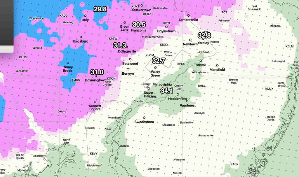
Updated Added Fri 09:08 AM — Mean low temperatures approach or below 32º from just west of the city and northwest around sunrise. (standard deviation is 1.5º to 2.2º’; think of it as ± 1.5 – 2.2º)
Model Blend (NBM) mean low temperatures before daybreak Saturday. (All have standard deviations of 1.5 to 2.0º) (Click image for a larger view.)
Uncertainty about the amount of cloud cover and instability showers on Saturday: the GFS and NAMNEST have sunshine becoming cloudy mid to late afternoon. High 48º sd 3.0º Windy to 30+ mph.
The new HIRESW-FV3 (pre-release version has significant periods of clouds and scattered instability sprinkles/(flurries?) throughout the day.