Update 11 pm- Tonight’s models have much more sunshine and no showers on Wednesday.
Low pressure moving to our south will merge and stack with an upper closed low far off the coast. It will intensify, expand and possibly retrograde back westward, affecting our weather through Friday. Closed low patterns are difficult for the models.
Wednesday will be mostly cloudy, some bright spots and possibly some sun mid-day. High 52. It will become WINDY in the afternoon and increasingly cloudy late afternoon.
There’s a chance of light sprinkles in the early morning and again late afternoon.
Best time to exercise outside is late morning and early afternoon.
[su_note note_color=”#bceaed”]Review: There wasn’t any sunshine and the models all predicted high temperatures that were almost 10º too high. The general timing of the showers was good, but they were heavier than expected. There was enough instability for thin line of thundershowers to develop and move through. [/su_note]
Clouds this morning may break briefly for some sun by noon.
Clouds move back in as a weak cold front will move through about 2-4 PM, with light showers. High 61º.
Clearing again before sunset.
The rest of the week looks to be mostly dry and somewhat cool.
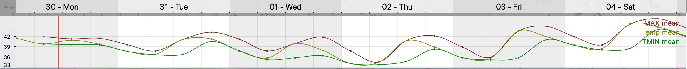
Week Outlook for Temperatures:
GEFS Temp forecast (Click for larger Image)
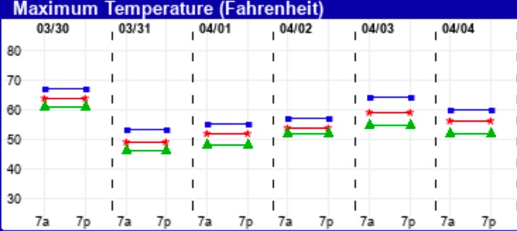
EKDMOS High Temp Forecast (Click for larger image)
Sunday Brief Update: Last night’s models continue with cool, cloudy conditions today. The warm front stays to our south and high temps may only be in the mid to upper 50s!
Light, scattered drizzle in the morning, a bit of brightening skies 12-4 PM, then some light, organized showers about 6-8 PM.
Best time for some exercise outdoors is from 12-4 PM.