THIS WEEK’S WEATHER

#Philadelphia #weather #PAwx

Folks, I’m on an extended escape in the mostly sunny climes along the Mediterranean sea. My forecasts will return the week of May 6th.

Tuesday Wednesday Outlook

Posted Monday 04/08/24 @ 7:58 PM — It looks like Tuesday will be the day for high cirrus cloudiness (maybe milky sky at times.) It will be quite mild with highs 76-78º ) (The Canadian has us reaching 80º, possible but not likely.)

An approaching warm front will bring rain as early as 1 AM Wednesday morning. As the front approaches any rainfall will be light and very widely scattered and there likely will be some sunny breaks. Still somewhat mild (60s) but the easterly or southeasterly flow will put a lid on temps.

NAEFS model statistical “mode” version with overlayed GEFS model “bias-corrected” precipitation forecast for Thursday (Click on image for a larger view.)

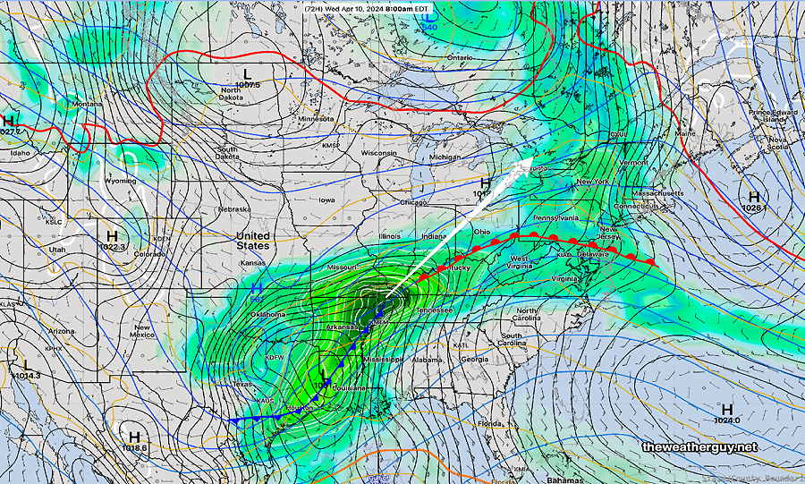
Very rainy and stormy Thursday. A secondary low will form towards the coast. A possible slow mover. Heavy rain possible! Stay tuned.


Eclipse Cloud Cover Update
Mon 6:04 PM —Forecast Review — Cloud cover in some places was as expected and was quite dynamic, changing throughout the peak eclipse point of 90% totality at 3:23 PM. Here’s the 3:45 RTMA cloud cover for time 3:30 PM—
3:45 PM RTMA which shows the cloud coverage at 3:30 PM today. (Click on image for a larger view.)

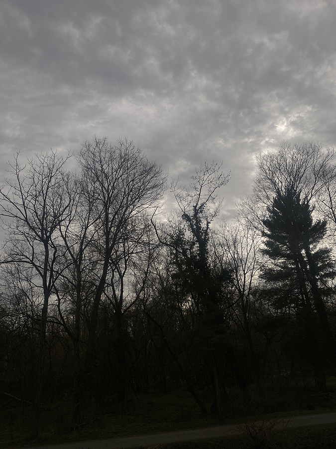
One thing to note. The areas of cloud cover here during the eclipse was not “milky sky” cloud cover, as described by several TV/radio broadcasts this morning and last night. ‘Milky sky’ refers to translucent cirrostratus clouds and sometimes high level altostratus. (Back when I learned about weather, it was referred to as ‘frosted glass skies’.)

Today’s cloud cover was altocumulus and relatively thick altostratus cloud cover, mostly mid-level clouds that are fairly opaque.

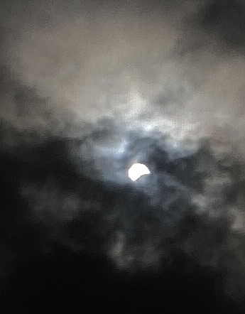
During the eclipse, I was having a late lunch outside Phoenixville. Here’s the sky at 3:20 PM—

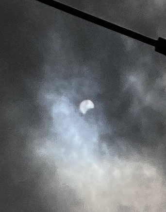
Here’s an iPhone capture at 2:52 PM, a half hour before maximum—


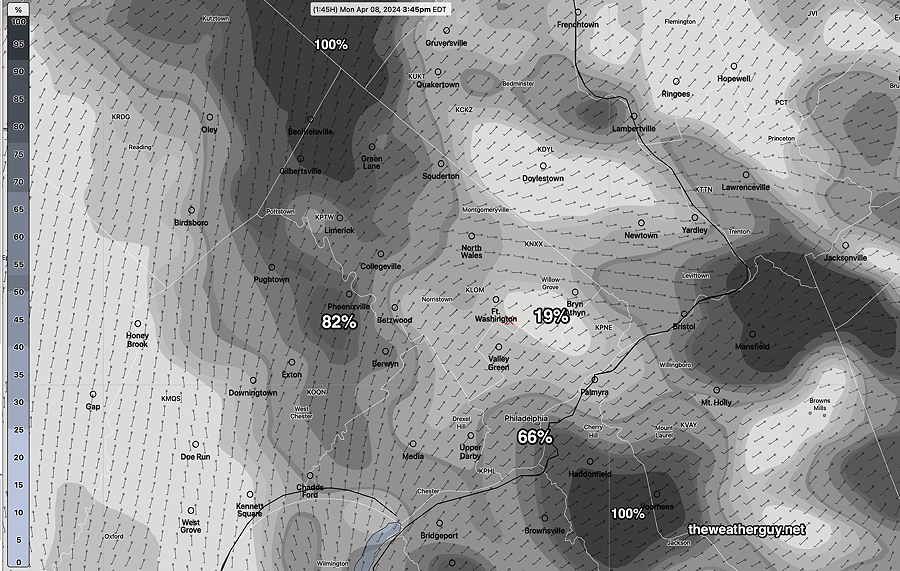
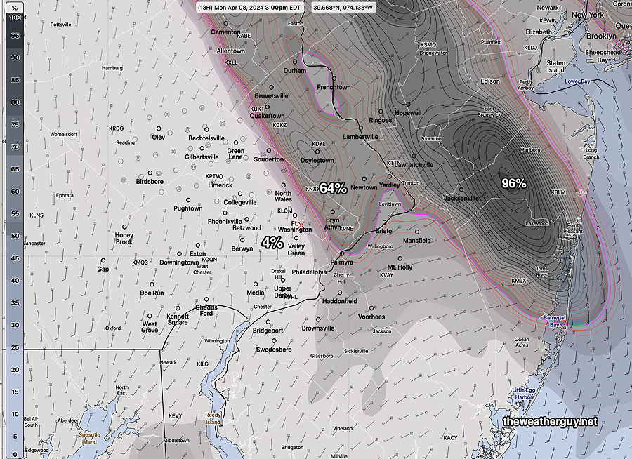
Posted Monday 04/08/24 @ 9:56 AM — After looking over a whole bunch of last night’s models, it still appears that some, but not all, areas around Philadelphia will have considerable cloudiness in the 3 PM time frame.

Here’s a few that are representative—

Canadian RGEM at 3 PM is the most optimistic with the least cloud cover over much of the area.

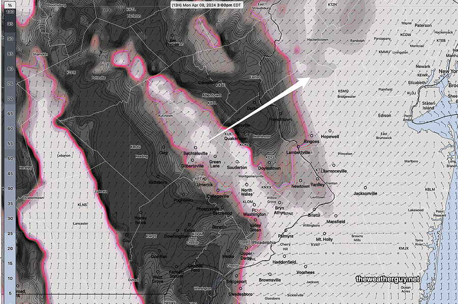
Here’s the Canadian High Resolution.

Canadian HRDPS shows areas of heavy cloudiness at 3 PM. (Click on image for a larger view.)

Least favorable is this morning’s HRRR, just available. It has a large swath of cloudiness in some parts of the area. (The HRRR tends to over-forecast cloud cover at times. Howver, its forecast is not that different than the German ICON which is pretty good with cloud cover. )

This morning’s HRRR (12z) forecast for 3 PM. Not very good, but the HRRR tends to over-forecast cloudiness in many situations. (Click on image for a larger view.)

I guess we’ll see. (quite literally)


Solar Eclipse Weather- Cloud Forecast Roundup

Originallly Posted Sun 7:54 PM —There’s an incredible level of interest in the solar eclipse on Monday. For the Philadelphia area, the maximum eclipse will occur about 3:23 PM to 3:24 PM. So what will the cloud cover be at that time?

Unfortunately, it doesn’t look like we’ll have a cloud-free sky. At the same time, I think there may be enough clear sky visibility in many areas to enjoy the event, but not all areas.

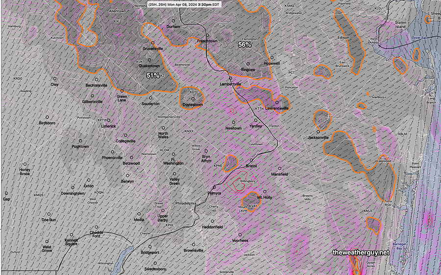
Cloud cover forecasts are one of those things that weather models really struggle with, especially when forecasting an approaching, poorly defined weather system. Such is the case tomorrow with a mid-level disturbance expected to move through during that same time period.

Most of the models are forecasting between 50% and 95% cloud cover, specifically mid-level clouds. The HRRR is closer to 97% but it tends to over-forecast cloud cover. With the ensemble models, the “spread” is about ± 35% in many areas, indicating moderate uncertainty.

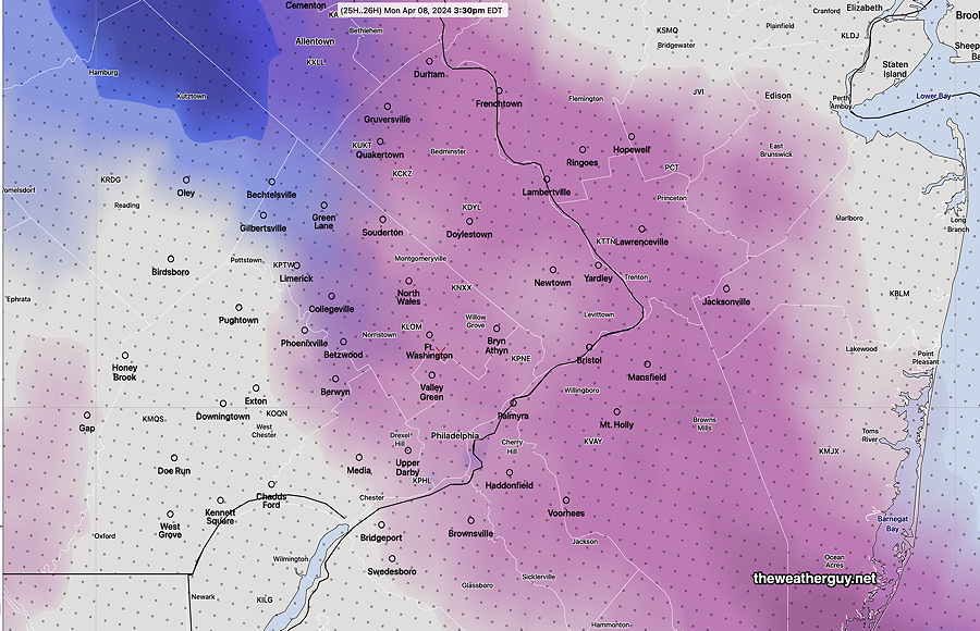
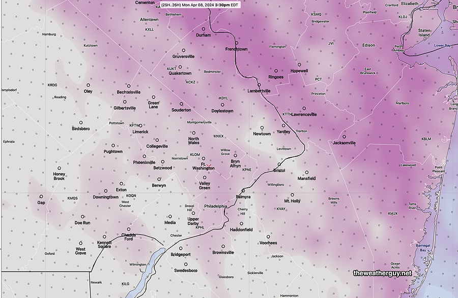
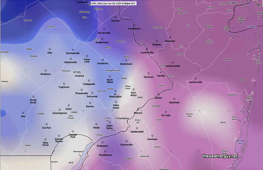
Here are a few of the latest models cloud cover forecast for Monday at 3:30 PM—

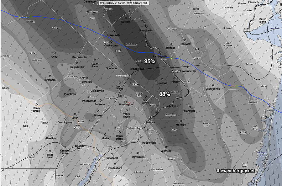
HRRR (possibly overdone) —
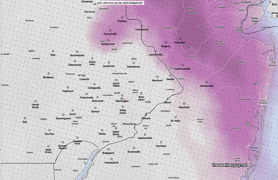
04-07-24 18z HRRR. The maroon is mid-level and the blue is low-level clouds. The HRRR tends to over-forecast cloudiness and it’s forecast has clouds of 97% in the dark maroon areas. (Click on image for a larger view.)

NAM-NEST

04-07-24 18z NAM-NEST 85-90% mid level with some areas higher. (Click on image for a larger view.)

HREF

HREF 18z forecast for 3:30 PM 40%-65% but spread is ± 35% (Click on image for a larger view.)

GFS

04-07-24 GFS forecast has some areas with 65% and some low clouds. Far northern Bucks and Montgomery counties are near 90% with low clouds. (Click on image for a larger view.)

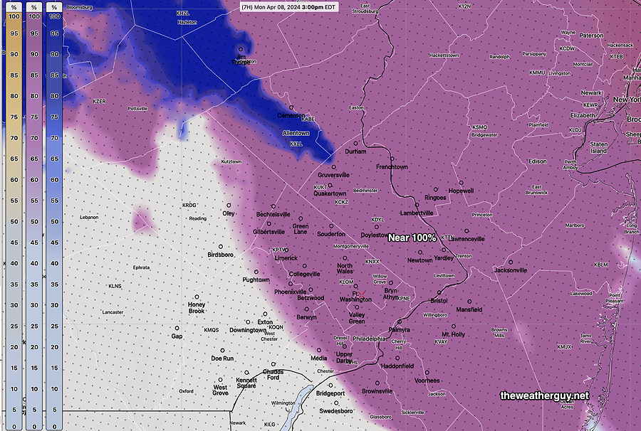
NBM— The NBM doesn’t break things down into low medium clouds. It does total cloud cover—

04-07-24 18z NBM cloud forecast. Pink/purple lines indicate areas of higher than average uncertainty. It’s overall cloud cover is about 45-50%. (Click on image for a larger view.)

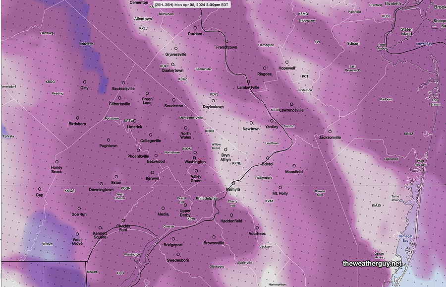
Canadian RGEM. Like the NBM, it doesn’t break things down into low medium or high clouds. It’s cloud forecasts are pretty good.

04-07-24 18z RGEM cloud forecast at 3:30PM. It has some considerable areas of cloudiness. I think this may be the best bet for accuracy tomorrow.
04-07-24 18z Experimental RRFS shows the upper air disturbance already moved through to our east. The model may not be ready for prime time. (Click on image for a larger view.)

So, what’s interesting and clear from these models— A disturbance is moving through our area just at the height of the eclipse. How much cloud cover at any one point is anyone’s guess. My preference is on the RGEM, NAM-NEST and GFS. Unfortunately, it doesn’t look like cloudless, blue sky conditions.

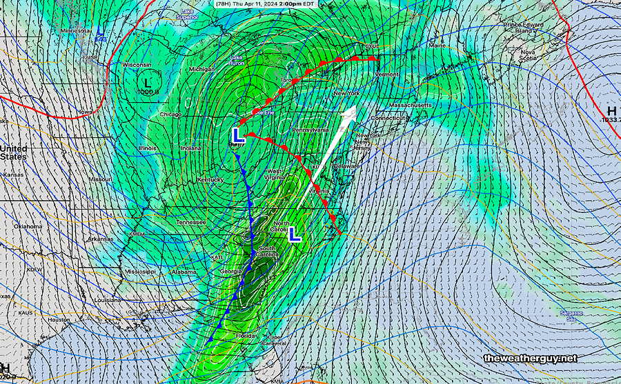
As for the rest of the week, another soaker may be setting up for Wednesday into Thursday—

NAEF forecast for Wednesday at 8 AM. Approaching warm front, with a large low pressure system to move up west of us on Thursday. (Click on image for a larger view.)

WEEKEND WEATHER FORECAST

#Philadelphia #weather #PAwx

Sat 12:58 PM —Forecast Review — Not the best Saturday forecast. I got the windy conditions forecast right, but the cloud cover today is more than I had forecast based on yesterday’s models.

Here’s the actual wind gusts at noon today—

RTMA wind and wind gusts at noon today. (Click on image for a larger view.)

Additionally, there are light sprinkles moving through the area, not forecast by any of yesterday’s models.

I took a look to see if any model last night had forecast these mid-day sprinkles and last night’s 06z ECMWF (not available until this morning) got this right.

However, the NAM-NEST missed it, as did the HRRR, HREF and Canadian models. I’m surprised by that.

Originally Posted Fri 7:27 PM —The deep upper and surface low of the New England coast will gradually move eastward. We’ll still be in the colder upper cyclonic flow through most of the weekend.

A warm upper ridge is poised to move in starting Monday, however, another storm system is expected by Thursday.

Here’s the current NAEFS forecast synopsis for Sunday at 11AM showing the departing upper low—

NAEFS model statistical “mode” version with overlayed GEFS model “bias-corrected” precipitation forecast for Sunday at 11 AM. Cold upper air feature is departing. Warm upper ridge ready to move in. (Click on image for a larger view.)

Saturday

Saturday’s weather will be similar to the past two days. Considerable sunshine in the morning with clouds and sun in the afternoon. VERY WINDY and gusty. Showers/sprinkles increasingly unlikely. Sunshine very late afternoon.

NBM high temperatures: Blue Bell, PA 52º Philadelphia, PA 54º
Average to low uncertainty (based on standard deviation): ± 1.5º

Sunday

Sunday will be similar to Saturday. Probably no sprinkles. A bit warmer and less windy.

NBM high temperatures: Blue Bell, PA 54º Philadelphia, PA 56º
Average to low uncertainty (based on standard deviation): ± 1.7º


Weather… and Other Things 'Up in the Air'