WEDNESDAY – THURSDAY SNOW UPDATE

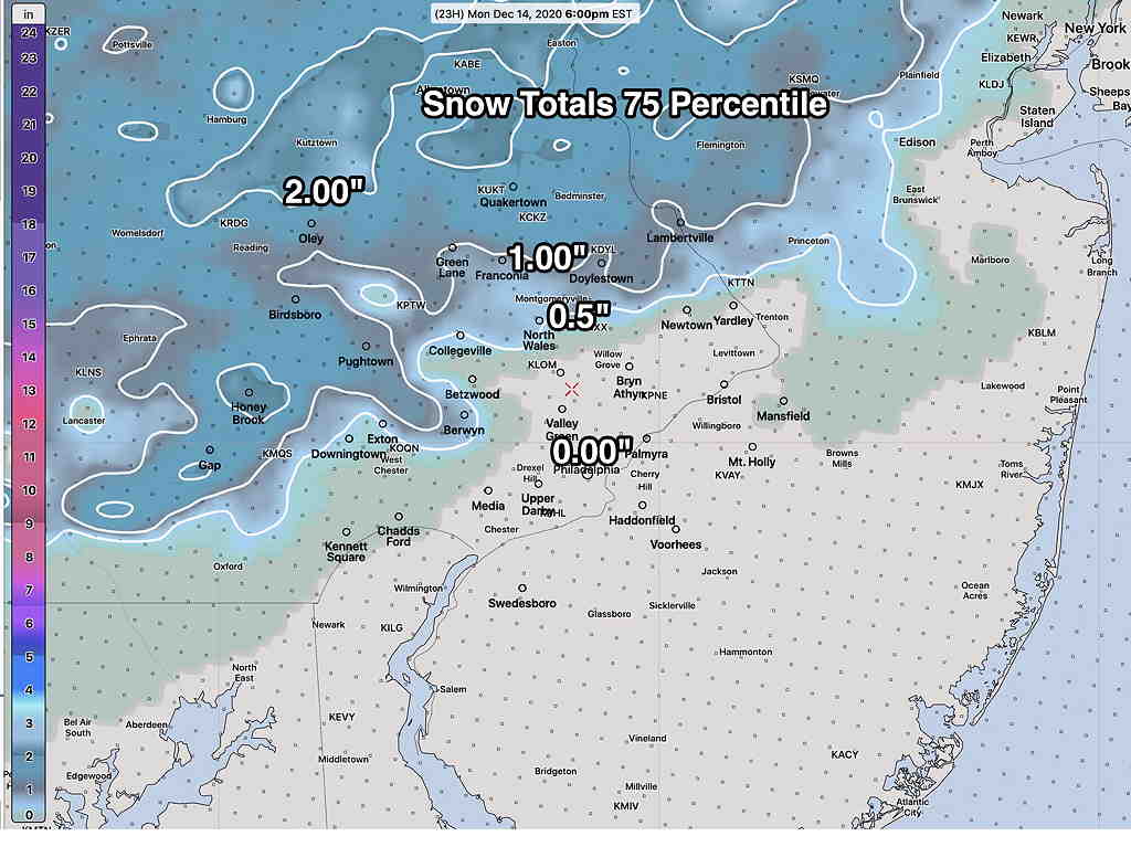
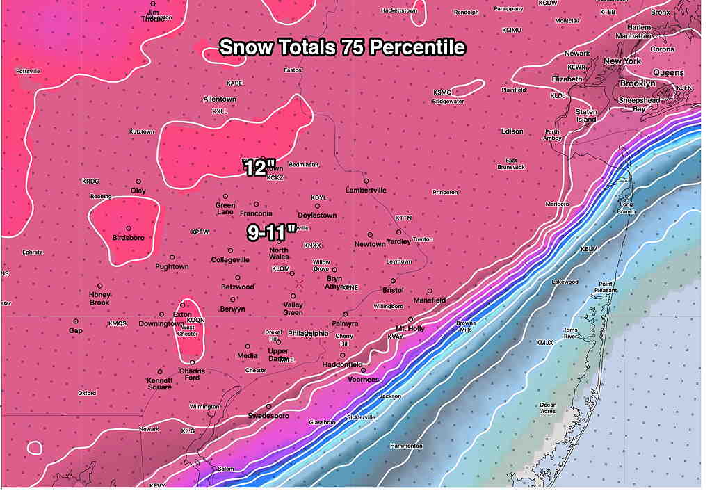
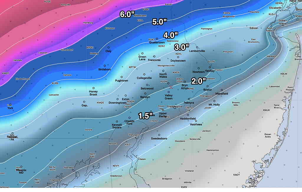
The latest models have become available for the snowstorm forecast for Wednesday afternoon into early Thursday morning.  Current timing is that snow starts about 2 PM Wednesday and ends around daybreak Thursday.  A significant nor’easter is forecast by most models.   The latest GFS snow totals forecast is also representative of the Canadian and ICON models—

GFS snow totals by Thursday morning.

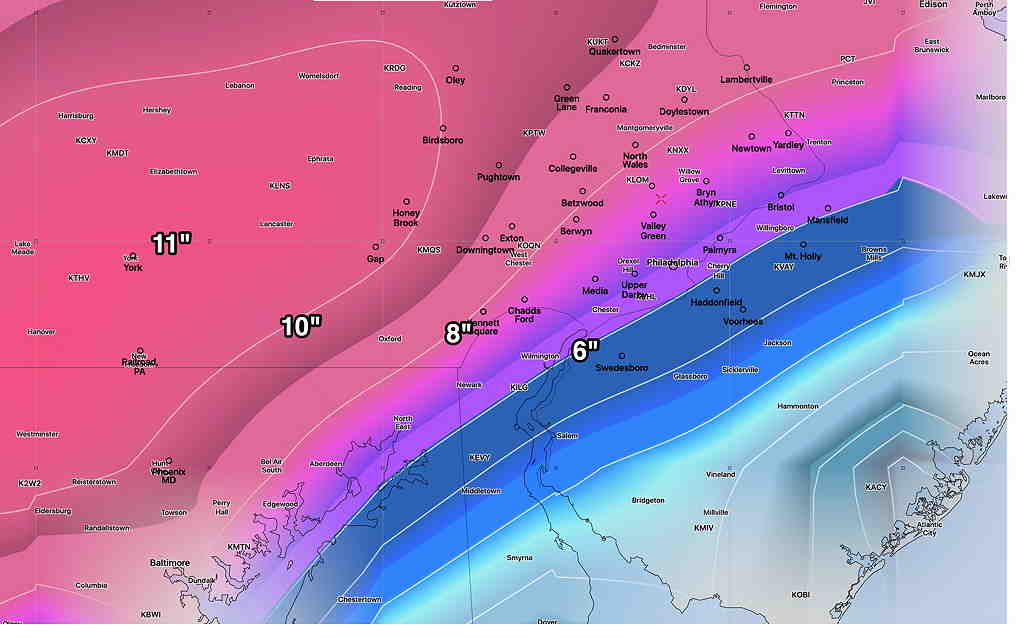
However, there has been a re-emergence of a complication that I had mentioned yesterday. The NAM, SREF and NAM-NEST have a wedge of warm air being drawn in at 3000 feet during the peak of the storm Wednesday evening, changing the snow to sleet or a rain-snow mix—

NAM model at 6 PM Wednesday.  Lavender line (white arrows) shows freezing temperature at 3000 feet north of the Philadelphia area.  This would result in a changeover to sleet and rain during the storm peak. (Click on image for a larger view.)

As a result, the NAM and NAM-NEST show snow totals much lower—

NAM Snow totals Thursday morning  (Click on image for a larger view.)

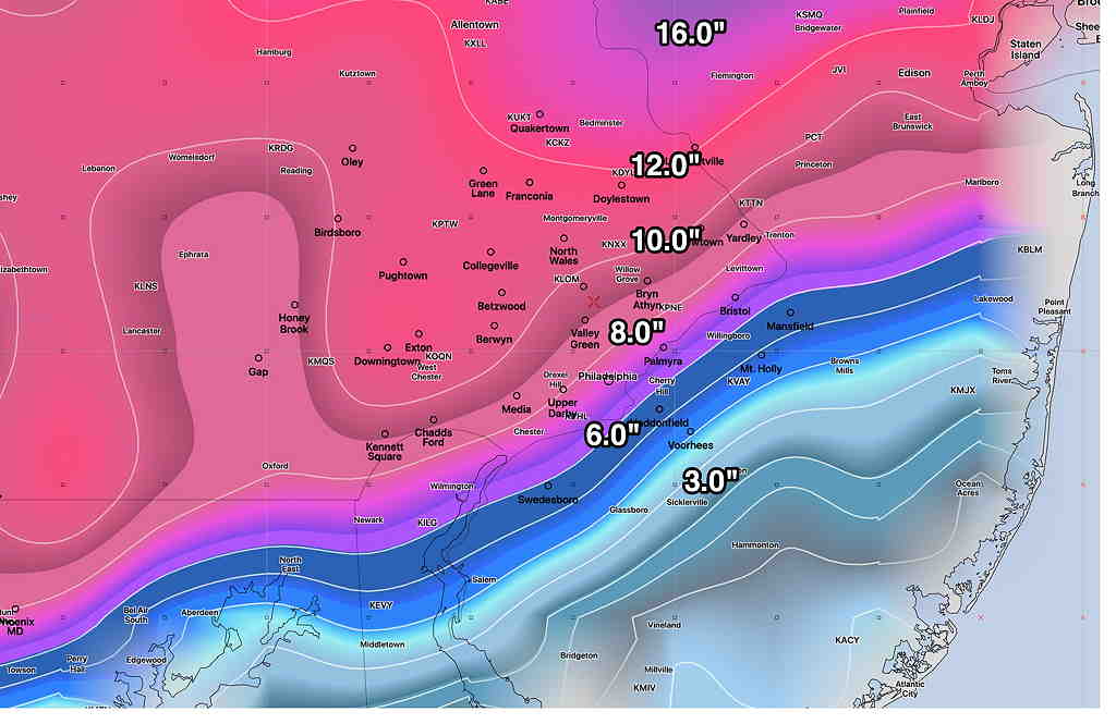
So there’s some real differences with the higher resolution models (that are just coming into forecast range) and the GFS, Canadian and current ICON models.

Most higher resolution models only forecast 48-60 hours in advance. They will begin to come into forecast range with this evening’s model runs and certainly by tomorrow late morning. Stay tuned.

MONDAY & Wednesday SNOW UPDATE

The latest models are just becoming available this evening. Most models have it too warm for snow in the immediate Philadelphia area.  Some snow accumulation is possible far western areas.  The NBM (National Blend of Models) 75 percentile snow accumulation captures it well. (75% of the constituent models and their statistical members are equal or below this accumulation amount)—

NBM 75 percentile snow forecast for Monday. (Click on image for a larger view.)


The latest HRRR and NAM, just available, is consistent with this NBM forecast. There may be some snow mixed with rain in areas that show zero accumulation towards the mid afternoon.

Rain starts around 6-8 AM Monday and ends about 3-4 PM.  It may briefly mix or change to snow in the western suburbs as it ends.


As for Thursday—


The models continue to show a major storm for Wednesday into Wednesday night.  It will be a stormy day by Wednesday afternoon with high gusty winds.  (At one point today, it appeared that warm air might move in, but the newest models are showing significant snow accumulation for Wednesday afternoon and night.) Here’s the latest GEFS snow totals by late Wednesday night—

GEFS Snow Totals (Click on image for a larger view.)


Here’s the NBM 75 Percentile snow totals—

NBM 75 percentile snow totals by late Wednesday night.  (Click on image for a larger view.)


Very clear is the sharp cut off in NJ as temperature will be too warm for much accumulation there.

I’ll be updating during the week. Stay tuned.

Weather… and Other Things 'Up in the Air'