Updated Sunday forecast, Sat 10:13 PM highlighted below
The weak front that moved through Friday evening will allow some drier air to move in for Saturday.
An mid-level disturbance may bring some clouds in the morning and even some sprinkles around noontime on Saturday, mostly far northwestern suburbs, but most of the day and the area will be partly sunny. High temp 84.7º ± 1.3º NBM Blue Bell.
For Sunday, the boundary that went through on Friday will return as a warm front. Considerable cloudiness in the morning with very some light showers possible, especiallyin far northern and western suburbs.
Clouds break for hazy sunshine Sunday afternoon with an increasing chance of showers and thunderstorms in the evening, especially western suburbs. The showers/thundershowers look less likely in Philadelphia and immediate suburbs.
Increasingly hot and humid. Dew points return to the uncomfortable upper 60s to near 70º. High 86.0º ± 2.6º NBM Blue Bell.
High 86.9º ± 1.7º NBM Blue Bell.
There is some uncertainty about the timing of showers on Sunday with the Canadian GEM having a somewhat different forecast than the GFS. Stay tuned.
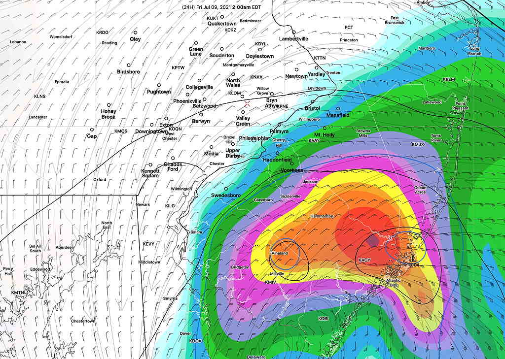
[note note_color=”#bceaed” text_color=”#333333″ radius=”3″]Fri 08:18 PM Forecast Review — The storms developed and moved just south of Philadelphia as picked up by the afternoon HRRR.
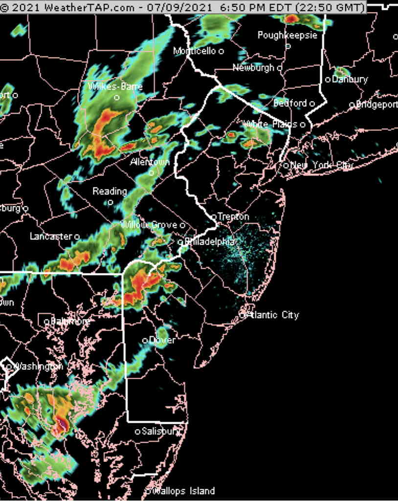
NEXRAD radar at 6:55 PM
[/note]
Updated Fri 4:25 PM, highlighted below, based on new HRRR Updated Fri12:30 PM, highlighted below, based on new HIRESW
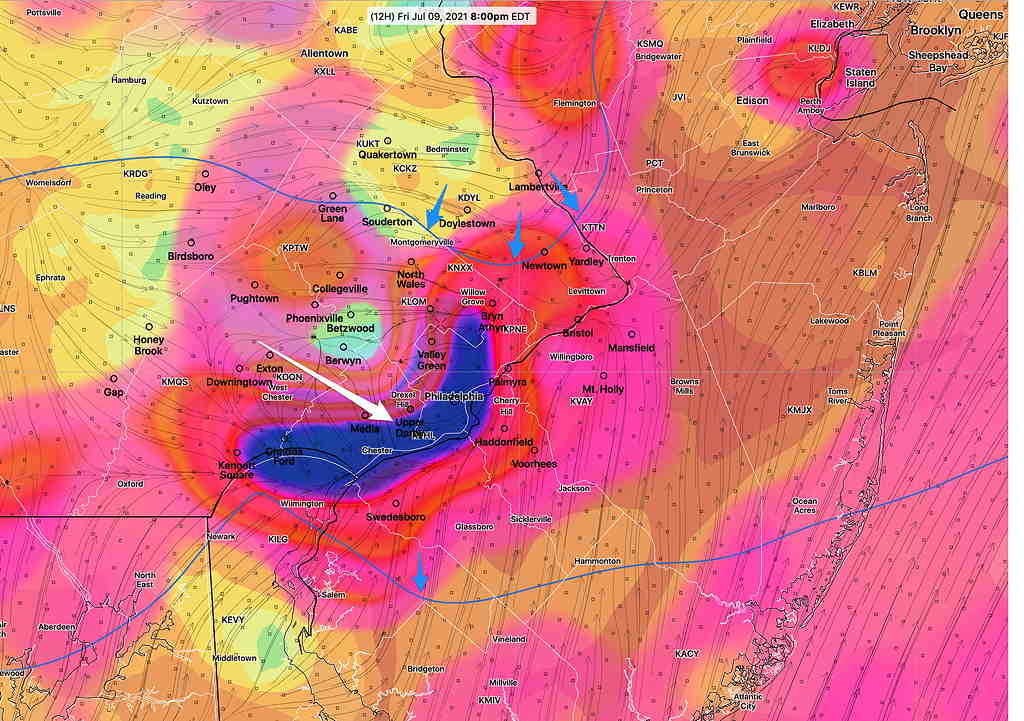
Strong thunderstorms expected early this evening. The latest HRRR shows all the ingredients coming together about 4:30 -8:30 PM 5:30 – 9 PM(peak 7-8 PM) in Philadelphia.
Update: The latest HRRR has the heaviest storms just to the south of Philadelphia
CAPE values in the 1600-2200 J/Kg range. Lifted Index moderately negative at -5. Very strong upward vertical motion is predicted to develop (blue shading/white arrow below) along with cyclonic upper air contour (blue arrows).
Heavy rain expected, especially from Philadelphia south and east.
HRRR 12z forecast for 8 PM showing very strong vertical velocity (blue shading/white arrow) right over Philadelphia and cyclonic upper air curvature. (blue arrows) (Click on image for a larger view.)
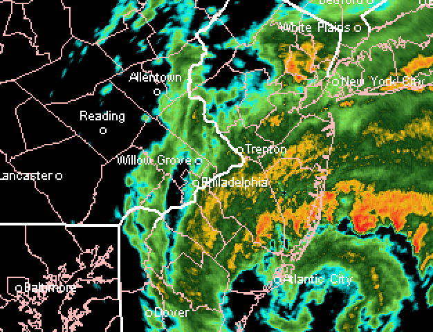
[note note_color=”#bceaed” text_color=”#333333″ radius=”3″]Fri 08:48 AM Forecast Review — The heavy rain had a sharp westward cutoff, as eventually predicted by the models late afternoon and evening yesterday. Here’s radar image from 4 AM showing the the heavy rain had a strong east-west cut off—
Radar 4 AM
[/note]
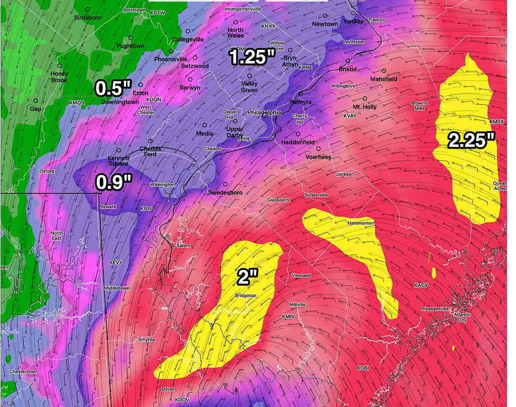
Updated on Thu 10:46 PM Tonight’s models have reduced the amount of rainfall and moved the heavy rain further eastward.
Updated on Thu 7:30 PM highlighted below
The latest Canadian Regional GEM model captures the sharp western cutoff in expected heavy rainfall that several afternoon models are showing—
Canadian Regional GEM rain forecast captures the sharp cutoff in heavy rain just west of the city. (Click on image for a larger view.)
The latest ICON model, which did very well with last year’s tropical storms, has the heavier rain further westward.
ICON model total rainfall. (Click on image for a larger view.)
Updated on Thu 5:59 PM highlighted below
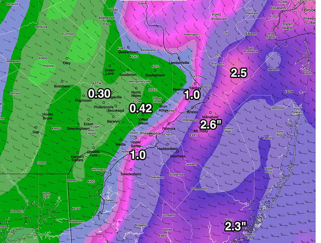
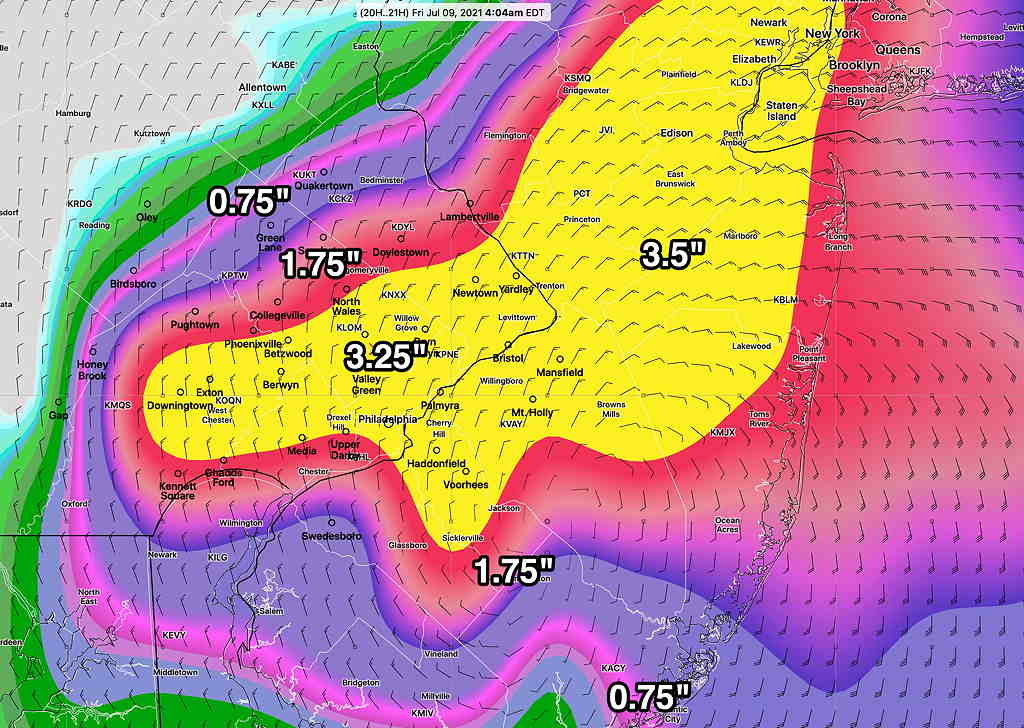
The afternoon model runs just are becoming available. The HRRR, the GFS and the HREF have a sharper cut-off of the heavy rain just west of Philadelphia with the heaviest rain most similar to the Model Blend NBM graphic below in the original post..
Updated on Thu 1:54 PM highlighted below
With the more westward track of the storm, the latest GFS has moved in the direction of the ICON and HREF models with 1.5-3.5″ of rain, extending into the Philadelphia area.
GFS model from 12z showing accumulated rain forecast by Friday morning.
The latest ICON model (which did very good with last year’s tropical systems) has less rain accumulation-
ICON model accumulated precip forecast from 12Z today. (Click on image for a larger view.)
Model Blend (which underestimated rainfall with last year’s tropical systems)
NBM (Model Blend) total rain forecast (Click on image for a larger view.)
A cold front is approaching from the Great Lakes and a pre-frontal trough will move through Thursday afternoon. Showers and thundershowers expected after 4 PM. Most of the thunderstorm activity will be expected in the far northwest areas, with heavy rain showers later this afternoon and evening in the Philadelphia area.
The remnants of tropical storm Elsa moves in later this evening and will affect us during the night time hours. The main effects of this storm will be high precipitable water and heavy rain. Not much wind expected (30 mph gusts), mostly at the shore. The storm exits early Friday morning.
Rainfall when it ends will be in the 1.5-2.5 1.5-3.5 inch range. Exact placement of the heaviest rain a challenge. The GFS keeps much of the heavy rain in NJ while the higher resolution models and the ICON have it overspreading the Philadelphia area. The Canadian GEM has the heaviest rain near Philadelphia! I’m leaning towards the heavy rain making it into Philadelphia.
GFS 1 hour 3 hour precip forecast for 3 AM Friday morning. (Click on image for a larger view.)HREF precip Forecast for 4AM Friday showing heavier rain into the Philadelphia suburbs. (Click on image for a larger view.)