Category Archives: Philadelphia Weather Outlook

THIS WEEK’S WEATHER

Friday Updates

Posted Friday 05/16/25 @ 4:38 PM — The first short wave moved through around noon. It kept together better than I had forecast. A second short wave will bring showers and thunderstorms here, also a bit later than had been earlier forecast.

Here’s the current radar at 4:50 PM—

Radar with superimposed RAP model Omega (Click on image for a larger view.)

The HRRR and NAM-NEST have these storms dissipating before getting here between 8 and 9 PM. The RRFS and Canadian HRDPS have the storms moving into our area. I’m leaning towards the RRFS.


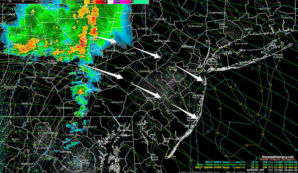
Posted Friday 05/16/25 @ 11:45 AM — There’s strong upper level support for the storms currently in western sections, but lower level support is lacking as it moves eastward at 11:44 AM. Let’s see which will prevails.

Radar with upper level RAP model Omega contours at about 11:44 AM (Click on image for a larger view.)

The models are showing less distinction between the original two short waves, now predicting showers and thunderstorms through the afternoon and early evening hours.


Posted Friday 05/16/25 @ 9:06 AM — A quick update. Latest radar shows a bow echo associated with the first of two short waves that will move across our area today.

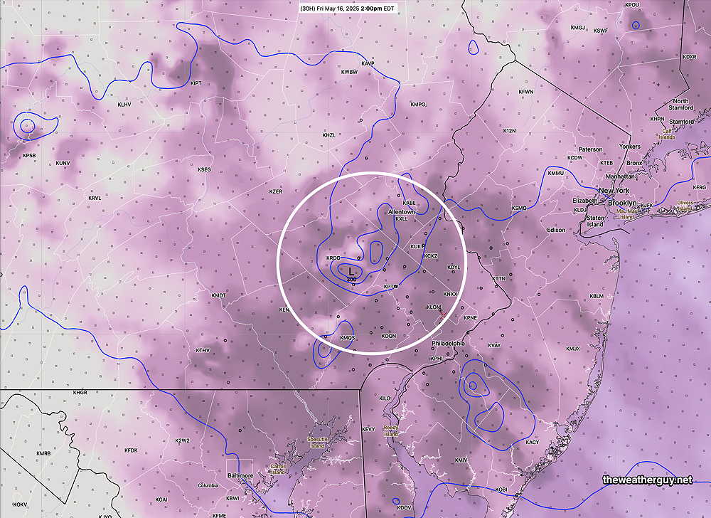
The current area of fast moving heavy rain rain/ strong storms is expected to weaken as it moves into Philadelphia later this morning. Some rain still possible with this batch. Current RAP model shows moderate downward motion ahead of this impulse consistent with some weakening.

Current composite radar at 9 AM with superimposed RAP model 700 wind streams and low level Omega. Omega is negative in our area, indicating weakening. (Click on image for a larger view.)

Another impulse expected later this afternoon (2-6 PM) will be fueled by higher CAPE values and higher vertical wind shear. Some stronger storms expected with this second short wave. I’ll update around noon with newer models.


Revised Forecast Posted Thursday 05/15/25 @ 7:40 PM — After reviewing the afternoon (18z) models which became available after my previous posting, I have to revise my forecast.

It appears that there will be two waves of energy that pass through on Friday. The first, in the late morning, will be strong in far western areas, but several models have this rapidly diminishing in intensity as it encounters a weak mid-level ridge over Philadelphia.

A second impulse moves through between 2 and 5 PM, as noted below, which appears to have more mid-level support, causing some very strong storms as it moves into NJ. We’ll see how it all plays out. I’ll update tomorrow morning.


Posted Thursday 05/15/25 @ 5:15 PM — A potent disturbance will move through during Friday afternoon. Previously expected around noon, the latest models have it moving through about 2-5 PM, earlier to our far west.

The upper air will support strengthening as it approaches, but it’s forecast to hit a weak mid-level ridge right over Philadelphia. Some models (HRRR) have it weakening and moving to our north and south over this ridge. The latest RRFS (experimental) maintains some of its strength and has it further intensify as it makes it across the river into NJ.

So this disturbance (called a “short wave”) is not looking as intense as it was yesterday, but some of the thunderheads may reach 50,000 feet according to the RRFS with fast onset heavy rains and winds.

RRFS 700 mb (10,000 feet) level short wave and Relative Humidity (shading) at 10,000 feet. Not shown are CAPE values which are in the 1000-1500 joule level and areas of vertical shear which exceed 25 1/sec. All the ingredients for storm formation. (Click on image for a larger view.)

The weather clears for Saturday, but a few widely scattered late day thunderstorms still possible.


Thu 5:11 PM —Forecast Review — We had the sun break out about mid afternoon, as forecast. Some areas, especially in New Jersey have been seeing some showers and low level thunderstorms.

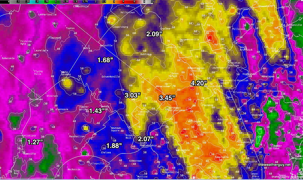
We’ve had quite a bit of rain over the past three days. Here’s a final summary, based on the MRMS

MRMS rain-gauge measured rainfall combined with rain-gauge calibrated and interpolated radar-based summary of ACTUAL RAINFALL RECEIVED over the past 72 hours. . Color shading is in inches. Line contour numbers are in mm. (25.4 mm= 1 inch)      (Click on image for a larger view.)

Thursday through Friday

Posted Wednesday 05/14/25 @ 5:28 PM —Following some scattered showers Thursday morning, many of us may finally see some sun Thursday by mid afternoon. Unfortunately the upper air will be cold and thermal instability will lead to scattered showers and thundershowers between 2 and 6 PM. A mix of clouds. sun and scattered storms sums it up for the afternoon.

Friday, a strong impulse rotating around the upper low near the Great Lakes will result in potentially some strong fast moving storms here around noon. Here’s the RRFS, which suggests a bow-echo formation around noon—

12z experimental RRFS simulated radar forecast for noon Friday.

The potential for damaging winds Friday with this impulse needs to be watched.


Wed 5:20 PM —Forecast Review —The experimental RRFS did better than the HRRR today regarding its forecast for lingering moisture and rain around Philadelphia this afternoon.

Posted Wednesday 05/14/25 @ 12:14 PM — Opted against going to the afternoon Phillies game. The morning models support a dry slot developing, and current radar/water vapor imagery shows dry slot advancing northward—

Satellite Water Vapor with superimposed composite radar at noon. (Click on image for a larger view.)

The hold-out for improving conditions is the experimental RRFS. It still shows some showers during the afternoon game. (Perhaps we’ll see why it’s still ‘experimental.)

14z experimental RRFS simulated radar at 2 PM. Could this be right?? (Click on image for a larger view.)
What about the Phillies Games today?

Posted Wednesday 05/14/25 @ 9:10 AM —It does look like there will be a relative ‘dry slot’ develop beginning about 2-3 PM today in the city. The latest HRRR (11z) shows rain exiting to the northwest.

Here’s the simulated radar forecast for 1 PM. There may be some showers at the scheduled game start—

11z HRRR simulated radar forecast at 1 PM As we always see, exact placement of forecast rain is more frequently than not inaccurate. (Click on image for a larger view.)

The latest HREF model, which is a statistical ‘ensemble’ of the HRRR, NAM-NEST and RAP models shows minimal rain for the hour preceding 2 PM —

06z HREF forecast 1 hour prior rainfall at 2 PM. (Click on image for a larger view.)

Additional rain is expected during the evening, but the models are leaning towards it being somewhat west of the city.

As for total rainfall so far for this event, this has been the most significant widespread rainfall we’ve had in a long time. Here’s the latest 48 hour total estimate—

MRMS rain-gauge measured rainfall combined with rain-gauge calibrated and interpolated radar-based summary of ACTUAL RAINFALL RECEIVED. Color shading is in inches. Line contour numbers are in mm. (25.4 mm= 1 inch)      (Click on image for a larger view.)

Wednesday Forecast Update

Posted Tuesday 05/13/25 @ 5:19 PM — The weather is unfolding as forecast, with a stream of increasingly heavy showers moving up from the south southeast around a closed upper low to our west.

The latest ECMWF-AI model has rain continuing tonight and becoming quite heavy by early morning Wednesday. Some thunderstorms may be in the mix on Wednesday. A total of almost 2″ of much needed rain is forecast for our area through midnight Wednesday.

ECMWF-AI forecast for 2 PM Tuesday. Heavy rain over our area. (Click on image for a larger view.)

It looks like some rain/showers continue on Thursday as the upper trough axis moves over us. Thunderstorms also possible.


Tuesday Forecast Update

Posted Monday 05/12/25 @ 5:56 PM — The forecast appears to be generally on-track with rain expected in the immediate Philadelphia area on or before 5 AM Tuesday morning.

Here’s the current satellite water vapor image—

Current satellite water vapor image with superimposed RAP model 500-1000 mb thickness lines (yellow), Mean Sea Level Pressure isobars (black contours) potential vorticity (fine violet contours) with superimposed MRMS RADAR. Upper level low (L) will gradually move north-northeast. Bands of rain will rotate up over our area at least until late Wednesday and likely into Friday. (Click on image for a larger view.)

Light showers to start, then bands of heavier rain move in later in the morning and continuing, with some breaks, through the afternoon and Tuesday night. Rain tapers off somewhat on Wednesday, but thundershowers will likely develop during the afternoon.

Total rainfall around 1 inch possible in and around Philadelphia, by Wednesday morning. more west of the city.


Posted Monday 05/12/25 @ 7:40 AM — This week’s model forecasts continues to evolve, with a shift towards some heavier rain in the immediate Philadelphia area by Wednesday. (I’ll have to see it to believe it.)

For today, sunshine through high cirrus clouds, with clouds thickening between 4 PM and 7 PM from southwest to northeast. Rain begins here before daybreak Tuesday, but much of the rain will be showery in the morning.

The chance of more moderate to heavy rain waits until later on Tuesday and most likely Tuesday night into Wednesday morning.

06z REFS (experimental( shows only light rain likely here at noon on Tuesday. At least initially, the heaviest rain will be west of our area. (Click on image for a larger view.)


Originally Posted Sun 8:17 PM —Monday will have sun through high clouds, then increasing cloudiness by 4PM. High temps similar to Sunday, near or just above 80º. Rain begins after midnight early Tuesday morning.

An active weather week ahead, where another upper level closed low will bring good chances for rain from before daybreak Tuesday through Friday.

Despite this forecast, it’s not entirely clear whether the needed heavier rain will be in and around Philadelphia, or continue a long standing pattern for the heavier rain to remain to our far north and west. Some models are showing heavier banding right over Philadelphia, but others (Canadian and various runs of the German ICON model and the RRFS) show the heaviest rain to our far northwest.

The latest GFS shows this west-northwest trend—

Today’s 18z GFS model forecast total rainfall through daybreak Wednesday. Greater accumulations by Friday. (Click on image for a larger view.)

Some models show just intermittent showers on Tuesday, while others are forecasting periods of moderate, continuous rainfall here. Too early to be sure.

There will also be the possibilities of thunderstorms during the week; the higher dew points, available moisture aloft and instability will set the stage for these storms, especially late afternoons and evenings.

Stay tuned.


THIS WEEK’S WEATHER

Fri 12:04 PM Update — The Trump Administration is withholding National Science Foundation funds. The MRMS and live Satellite Water Vapor data I obtain from Unidata and post on this site will become (what is termed) “temporarily unavailable”, as all staff are being suspended this weekend.

There’s a long list of unthinkable things happening. How bad will things get??

Fri 9:44 AM —Forecast Review —The models did quite poorly with this rain event: the onset of the rain in Philadelphia was off by almost 8 hours and the axis of heavy rain was far northwest of the city, not where forecast and, not where it’s needed.

While the models did have a band of heavy rain northwest of the city, the delay on eastward movement last night seriously cut into potential rainfall near the city and in NJ.

Here’s the preliminary MRMS rainfall totals (called Pass 1) as of 9 AM—

MRMS rain-gauge measured rainfall combined with rain-gauge calibrated and interpolated radar-based summary of ACTUAL RAINFALL RECEIVED. Color shading is in inches. Line contour numbers are in mm. (25.4 mm= 1 inch)      (Click on image for a larger view.)

Additional rain to our west was originally forecast to move in during Friday. The latest RRFS has this rain falling apart as it approaches the city. (Can we believe it?) Here’s current radar at 9:45 AM—

The tendency for rainfall to stay to our northwest and to dissipate near the city and eastward does not portend well for our area or NJ for the coming summer.

The tendency towards dry conditions (drought) still seems to be in play and it’s a trend that began late Spring 2024.

Thursday Forecast Update

Posted Thursday 05/08/25 @ 7:47 AM — The big question for today— when will the showers move into our region? Most models show isolated or widely scattered showers and thundershowers as early as 3-5 PM, mostly in northern and western suburbs.

The ECMWF-AI still maintains dry conditions for most of us, except northern suburbs) until at least 5 PM. However, statistical ensemble models (NBM, HREF, REFS) all show a good chance of some widely scattered or isolated showers as early as 2-3 PM.

The latest hourly RRFS (10z) captures the isolated nature at 4 PM—

Today’s 10z RRFS simulated radar/cloud forecast for 4 PM – Isolated/scattered showers/thundershowers. As is always the case with models, the exact location is often inaccurate, but it captures the general trend. (Click on image for a larger view.)

The NBM (model blend) shows a similar configuration. By 5 PM, the NBM shows this hourly probability of any rainfall—

06z NBM probability of any rainfall (>0.01″) at 5 PM. I generally find that any hourly probability greater than 18% (green shading) is a good bet.(Click on image for a larger view.)

Showers and thunderstorms are likely this evening and tonight into much of Friday.


Thursday-Friday

Posted Wednesday 05/07/25 @ 5:29 PM — Another upper low pressure system will approach our area Thursday into Friday, and will exit by early Saturday.

Current satellite water vapor image 5PM with superimposed RAP model 500-1000 mb thickness lines (yellow), Mean Sea Level Pressure isobars (black contours) potential vorticity (fine violet contours) with superimposed MRMS RADAR. Upper low approaches during the afternoon Thursday.

The big question (read uncertainty) is when the rain associated with this system will arrive here. Most models have some showers and thundershowers in northern Bucks county and Lehigh county by 12 PM – 3 PM Thursday afternoon. Less certain is the possibility of some showers and thundershowers developing in and around the immediate Philadelphia during the afternoon.

The ECMWF-AI model keeps the showers out of our immediate area until late afternoon, becoming likely between 6 and 8 PM. The experimental RRFS shows some isolated showers developing as early as 3 PM, becoming increasingly likely as the afternoon unfolds.

A mix of sun, clouds, and sunshine through clouds is a good bet for the afternoon with a chance of these scattered/isolated showers.

Experimental RRFS forecast time lapse gif (Click on image for a larger view.)

Also a good bet is for showers and thunderstorms developing as early as 5 PM but very likely between 6 PM and 8 PM Some of these will move in from the west, but many will spontaneously develop in place.

Rain continues Thursday night and through much of the day Friday, likely ending Friday evening. A decent rainfall (0.8″ – 1.5″) is expected, with heaviest rain expected north and northwest of the immediate Philadelphia area.

The weekend looks good!


Wed 9:12 AM —Forecast Review — I just wanted to post the 72 hour total rainfall from our most recent weather maker—

3 day rain totals MRMS rain-gauge measured rainfall combined with rain-gauge calibrated and interpolated radar-based summary of ACTUAL RAINFALL RECEIVED. Color shading is in inches. Line contour numbers are in mm. (25.4 mm= 1 inch)   There was quite a range over small distances. Many areas received very little rain.    (Click on image for a larger view.)

Forecast Review & Wednesday Update

Posted Tuesday 05/06/25 @ 5:47 PM — Sunshine did develop by noon and showers did break out from daytime heating, but mostly just to the west of the immediate Philadelphia area; many areas saw no rain, just periods of cloudiness —

Radar loop from 12:54 to 1:35 PM today. (Click on image for a larger view.)

The upper low is finally moving out to the northeast and Wednesday looks to be partly to mostly sunny with sunshine continuing through cirrus clouds in the afternoon. No rain!

Another upper level feature, an upper trough with an upper low center brings rain late Thursday afternoon or evening.

Today’s 12z ECMWF-AI forecast for Thursday at 8 PM. (Click on image for a larger view.)

A surface low is forecast to develop on Friday near the mid-Atlantic area bringing more rain on Friday, likely clearing out early Saturday.

Despite all the clouds and showers over the past three days, many areas have not received all that much rainfall—


Posted Tuesday 05/06/25 @ 8:54 AM — Some other models coming in — the hourly HRRR continues with a break out into sunshine later this morning. The hourly RRFS has some cloudiness lingering around the city with spotty showers breaking out by noon.


Self-Destructive Sunshine

Posted Tuesday 05/06/25 @ 7:38 AM — An area of showers moved through before daybreak. Sunshine is expected in many areas between 11 AM and noon.

7 AM water vapor satellite image with superimposed RAP model 700 mb wind streams and vertical velocity pressure (omega). Drier, low level warm air (orange) will move up into our area while cold air associated with the upper low remains in place aloft. This unstable condition will result in showers developing around area 1 and these will move into our area between noon and 4 PM. (Click on image for a larger view.)

The sunshine will result in heating at the surface while cold air aloft associated with the upper low will combine into a thermodynamically unstable situation, what I like to call “self-destructive sunshine”. (Despite the atmosphere being in therapy for years, it still reverts to this self-destructive behavior) Showers and thunderstorms, some with locally heavier rainfall area possible from noon through 4 PM and perhaps later as well.

00z REFS (experimental) forecast for 3 PM. Prior 1 hour mean rain combined with statistical spread. Not all areas in green will be receiving rainfall. (Click on image for a larger view.)

It’s looking better for Wednesday, with sunshine and less chance of showers.


Tuesday Forecast Update

Posted Monday 05/05/25 @ 5:59 PM — As expected most areas around Philadelphia received very little rainfall today, although a few bands of heavier rain went through Chestnut Hill and areas north and west of the city. Fairly close to the precipitation “hole” forecast earlier this morning.

Unfortunately, the very heavy total rainfall predicted by the AI models for with this closed low have not materialized for many areas. Here’s the current preliminary MRMS estimate of actual rainfall for the past 48 hours—

MRMS rain-gauge measured rainfall combined with rain-gauge calibrated and interpolated radar-based summary of ACTUAL RAINFALL RECEIVED. Color shading is in inches. Line contour numbers are in mm. (25.4 mm= 1 inch)      (Click on image for a larger view.)

There’s a promising development for Tuesday‘s weather as several models are forecasting a dry slot and significant some sunshine from late morning Tuesday through about 4-5 PM.

For the daring who wish to plan outdoor activities on Tuesday, the chance of a scattered shower during the time period above is still vdry possible, as the HRRR has spotty localized showers/storms developing due to the daytime heating.

Here’s the REFS forecast hourly rain with statistical spread—

12z REFS mean rain and statistical spread forecast for 3 PM Tuesday. Sunny where it’s not raining. (Click on image for a larger view.)

So cloudy in the morning, then sunshine by late morning with areas of localized rain/thunder is the forecast for much of the day.

Rain returns Tuesday night into Wednesday morning, again spotty coverage.


Monday

Originally Posted Mon 10:17 AM —This week’s weather continues to be influenced by an upper level low pressure system in the Ohio Valley. Areas of vorticity (disturbances) rotate around this low, inducing showers and thunderstorms.

Current satellite water vapor image with superimposed RAP model 500-1000 mb thickness lines (yellow), Mean Sea Level Pressure isobars (black contours) potential vorticity (fine violet contours) with superimposed MRMS RADAR. Upper level low with areas of potential vorticity wrap around this low and will bring periods of rain and thunderstorms through Tuesday. As you can see, the rain usually occurs a certain radius (600 miles) from the center. (Click on image for a larger view.)

A close-up shows areas of ‘potential vorticity’ (violet contours) inducing showers and storms. Think of these as eddy currents around a main circulation and they usually develop a certain radius from the center (~600 miles or so) —

Periods of rain and thunderstorms are expected through Tuesday. As has been the case this weekend, exact timing and placement of these disturbances are difficult to forecast accurately and each model has their own solution.

The latest ECMWF shows much of the activity staying to the east and west of Philadelphia today—

06z ECMWF forecast for 5 PM. Philadelphia lies on a ‘gap” of little precipitation today according to this model. (Click on image for a larger view.)

A high resolution ensemble model, the REFS (experimental) supports this forecast of minimal rain here in the city during the daytime Monday. The REFS is a composite model (an ensemble or group of 12 model runs) consisting of time-lagged versions of the RRFS and the HRRR. It attempts to average out the model run variations and errors that routinely occur.

Experimental 06z REFS showing the same ‘gap’ in the precipitation shield over Philadelphia today. (Click on image for a larger view.)

Just because the models show a ‘gap’ in the rain unfortunately does not guarantee that the immediate PHL area won’t see any rain during the daytime hours on Monday. We could use the rain!!

These upper air lows and their associated precipitation are rarely forecast accurately.

Stay tuned.

A note for those of you who are visiting this site from “X“.


Due to the highly unbalanced political environment on X, I’ve considerably cut back auto-posting there. To receive ALL of my forecast postings, I recommend following me on mastodon.social or bluesky.social


THIS WEEK’S WEATHER

Friday Forecast Update

Posted Friday 05/02/25 @ 8:46 AM — A clean-cut forecast for the next three days will be difficult. There’s significant spread in the model guidance for today. The ECMWF-AI model has probably done the best overall with last night’s lack of rain and I’m going to lean towards it.

That said, the ECMWF-AI has low temporal and spatial resolution (forecasts every 6 hour and a grid size of about 17-21 square miles; in comparison, the RRFS is hourly and and a grid size of a little more than 1.8 miles.) So we have a choice of better accuracy with low resolution or poor accuracy or high resolution.

A mix of sun and clouds today (Friday) with a slightly increasing chance of very widely scattered showers (and even thundershowers) later this afternoon and tonight. Most likely locations are north and west of the city. Confidence is below average.

To capture the range of forecast for today, here’s the HRRR and HRDPS, two high resolution models—

06z HRRR- No rain here before 7 PM ? (Click on image for a larger view.)
06z Canadian HRDPS -scattered rain/thunder before 7 PM Friday (Click on image for a larger view.)

As far as the Sunday Philadelphia Broad Street Run, there are signs that the heavier rain will occur Saturday night and before daybreak Sunday. There may be a break in the rain for much of the morning hours.


Forecast Update

Posted Thursday 05/01/25 @ 7:39 PM — The showers forecast by the GFS and RRFS are missing in action. (As mentioned earlier today, the ECMWF and the ECMWF-AI kept the rain to our north and west this evening.) With the latest HRRR and NAM-NEST also keeping us fairly rain-free this evening, a forecast of showers this evening seems increasingly unlikely. Yet a warm front sometimes sneaks some showers in later at night, so we’ll have to see.

A strong area of vertical motion around Washington DC may trigger some showers later tonight. (Click on image for a larger view.)

Friday looks to be sunny through high clouds again. Some widely scattered showers are forecast for the afternoon. The closed low pattern bringing rain will begin during the day Saturday.


Rainy Pattern Looking Increasingly Likely

Posted Thursday 05/01/25 @ 8:34 AM — The GFS has joined the other global models forecasting a cut-off upper level low to develop in the Mississippi/Ohio Valley over the weekend. Before that time, the disturbance shown in yesterday’s water vapor image will move up to our area and bring some much needed rain as early as this [Thursday] evening, ahead of a warm front.

Here’s the latest GFS forecast for 7 PM —

06z GFS forecast for 7 PM Thursday evening. Black-Grey is cloud cover. Warm front from the southwest moves up with showers and maybe some thunderstorms. (Click on image for a larger view.)

It should be noted that the latest ECMWF-AI model has much less rain for us this evening than the latest GFS. The latest experimental high resolution RRFS supports the GFS—

06z RRFS forecast for 9 PM this evening. (Click on image for a larger view.)

Following the warm front, Friday should become sunny through a layer of high cirrus clouds. It will be warm and humid. Some showers and thunderstorms break out Friday evening.

For Saturday, the GFS has a mix of clouds and sunshine with thunderstorms later in the afternoon/evening. The ECMWF-AI is forecasting showers even during the daytime hours on Saturday.


Blocked Pattern and Rainy Period Possibly Developing

Posted Wednesday 04/30/25 @ 5:17 PM — A complex transition to a possible blocked pattern giving us much needed rain is beginning to take shape for this weekend, but with significant uncertainty. The caption below explains the current situation.

Current satellite water vapor image with superimposed RAP model 500-1000 mb thickness lines (yellow), Mean Sea Level Pressure isobars (black contours) potential vorticity (fine violet contours) with superimposed MRMS RADAR. The area of showers and storms will move up into the Great Lakes (White Arrow), with much of the rain missing us. Energy diving down from Canada (blue arrow) will cause the development of a closed upper level low by Sunday. The position of the low is uncertain, but the Canadian/ECMWF/ICON models have the position of this upper low in the Ohio Valley. The GFS and GEFS have the upper low near South Carolina. The AI model also has the low in the Ohio Valley and this would give us plenty of rain. (Click on image for a larger view.)

As described in the above caption, there is a wide spread of uncertainty with this position of this upper closed low, but I’m leaning towards the Canadian/ECMWF/ICON and ECMWF-AI model forecasts. Here’s the latest ECMWF-AI forecast—

ECMWF-AI forecast for Sunday at 8 AM. Closed low over Ohio Valley will bring extended rain to our area if this scenario develops. It should be noted that the GFS and GFS-AI models show this low in South Carolina, significantly reducing our chance of much needed rain. (Click on image for a larger view.)

As described in the water vapor image caption, the large area of rain currently in the Midwest will pass to our north and west through Friday, with little rain here at least through Friday.

We’ll see if the GFS joins the other models with the position of the closed upper low resulting in a rainy several days from the weekend and beyond.


Posted Tuesday 04/29/25 @ 6:22 PM — Current radar and water vapor shows the expected line of storms. (almost appears as a “bow echo”, indicating fast, strong storms.

Current radar (about 6 PM) with vertical motion (omega) indicated. (Click on image for a larger view.)

Today’s models still have the showers/thunderstorms falling apart as they approach Philadelphia, due to lack of upper air support, as outlined below.


Posted Tuesday 04/29/25 @ 8:32 AM — An approaching cold front this evening may threaten rain. “Threaten” will likely be the extent of it.

Current (Tuesday morning) satellite water vapor image with superimposed RAP model 500-1000 mb thickness lines (yellow), Mean Sea Level Pressure isobars (black contours) potential vorticity (fine violet contours) with superimposed MRMS RADAR. I’ve drawn yellow arrows to accentuate the upper air flow over us. The reason will be explained below. (Click on image for a larger view.)

Today should be a perfect example of why I rarely use the term “tracking” when it comes to weather and areas of rainfall in particular. Let me explain—

This evening, about 8 PM, if you were to look at the radar image for Pennsylvania, you will likely see a giant area of heavy rain just to our west, moving eastward. You might think, “Gee, I’ve been watching (“tracking”) this and it looks like it’s going to move right through Philadelphia”.

You’d be wrong. Weather is much more dynamic and three dimensional than what appears to be “trackable” on radar. Here’s why:

At the surface, a cold front and preceding trough will be approaching—

Surface Forecast (ECMWF-AI) for 8 PM this evening Cold front, preceding trough at the surface and a large area of rain. (Click on image for a larger view.)

In the upper atmosphere, though, the wind flow is “anticyclonic”, there is a strong upper ridge axis that can thought of as physically blocking the rainfall and the position of the jet streak will be such that we are not in area of upward vertical motion (what’s called the” right entrance region”—

ECMWF-AI Jet Streak winds show the jet stream wind flow over us is “anticyclonic”, there is a strong upper ridge axis that can thought of as physically blocking the rainfall and the position of the jet streak will be such that we are not in area of upward vertical motion.

The rain should diminish and fall apart. If you were “tracking” this area of rainfall as it moves eastward without the knowledge of the upper atmosphere, your forecast of the heavy rain moving into Philadelphia would be wrong!

The TV people sometimes say “that area of rain will fall apart as it approaches us”. They don’t explain why, but this is why.

Of concern— this feature last summer resulted in many missed rainfall events and our drought.


Previously Posted Mon @ 8:39 AM — —This week’s weather looks quite nice, especially today- Monday. Light winds, low humidity and ideal temperatures in the mid 70s. (76º Philadelphia , 74º (Blue Bell.)

Tuesday also looks quite nice- sunshine through high cirrus clouds, but it will become quite WINDY ahead of a disturbance Tuesday night that will bring showers to western suburbs, with maybe a sprinkle near Philadelphia. (The trend of showers remaining west continues!)

Highs near 81º.

06z REFS (experimental) 1 hour rainfall 11 PM Tuesday night. Most of the rain stays to our northwest. (Click on image for a larger view.)

Clearing by Wednesday morning with highs in the low 80s!

The disturbance that passed us to our northwest early Wednesday will bring a cooler easterly flow on Thursday.

Another system approaching late Thursday will bring rain on Friday, possibly lasting into the afternoon/evening on Saturday.

Current AI forecast for 8 PM Saturday

06z ECMWF-AI Single forecast for 8 PM Saturday. Showers and thunderstorms with a cold front. Notice the light blue contours capturing the dip in the jet stream. Cooler temperatures for Sunday! (Click on image for a larger view.)