Posted Thursday 06/05/25 @ 5:37 PM — The forecast for Friday and the coming weekend remains “up in the air”. The general trend has been for much of the area from the city and eastward to remain rain-free for Friday with increasing chances of some scattered showers at times during the day Saturday.
I think a few weather maps capture the current trend—
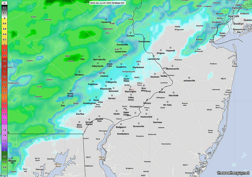
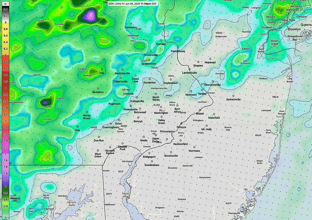
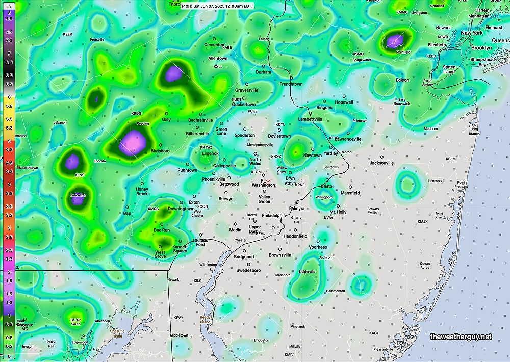
18z Model Blend (NBM) has no rain in the city or at the shore on Friday. (Click on image for a larger view.)18z HREF, an ensemble blend of the NAMHRRR and HIRESW-ARW is similar to the NBM forecast. (Click on image for a larger view.)12zREFS (experimental), an ensemble blend of the RRFS and the HRRR shows showers more eastward. (Click on image for a larger view.)
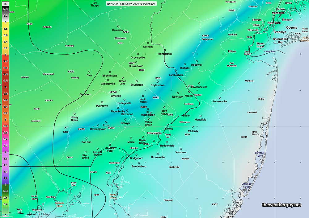
The European AI model, the ECMWF-AI Single, is closer to the REFS forecast, bringing the chance of light showers into NJ—
12z ECMWF-AI total rain forecast through Friday. (The ECMWF-AI suggests more widespread rain, but its forecast appearance is the result of it being a low resolution model) (Click on image for a larger view.)
So, we’ll see which model does the best with this system and l’ll lean on it for the weekend forecast tomorrow.
Thursday into the Weekend
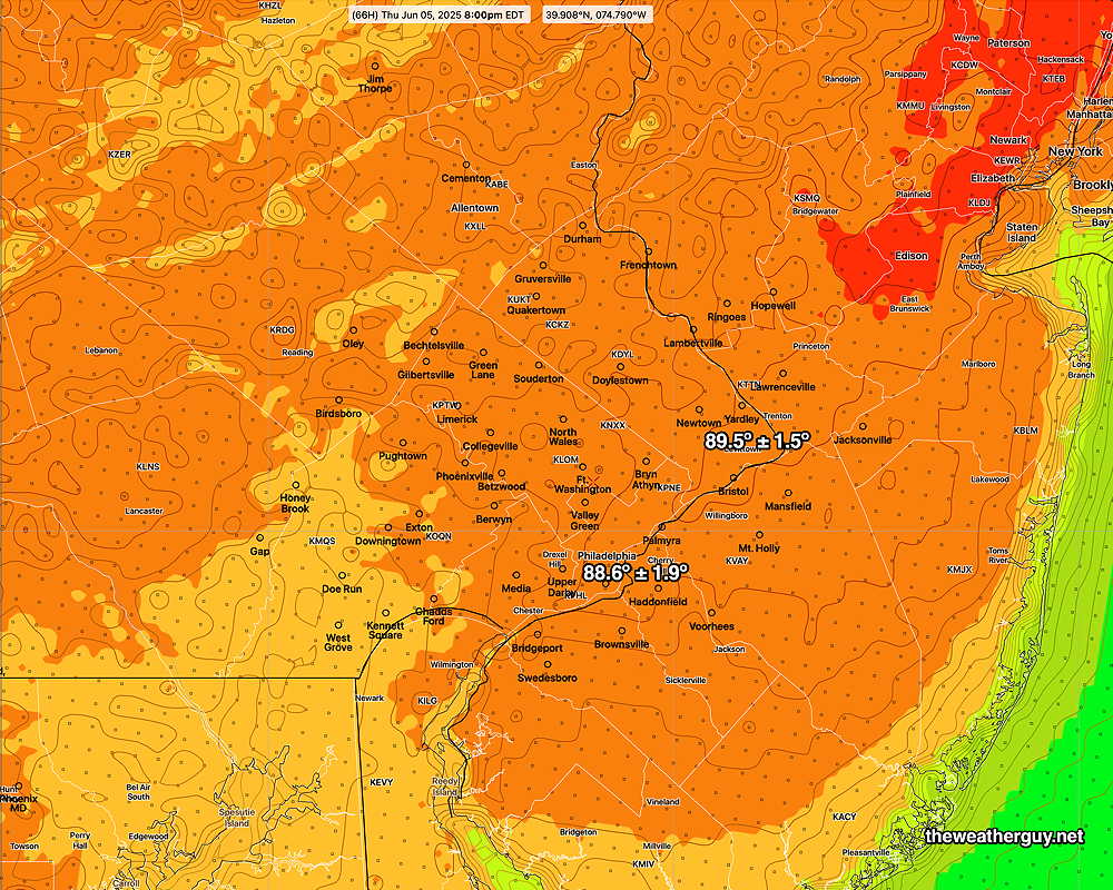
Posted Wednesday 06/04/25 @ 5:41 PM — The smoke at several levels of the atmosphere may reduce the high temperatures on Thursday (originally expected to be near or above 90º according to the AI model) by a few degrees. The models are clustering closer to 88º to 89º for Thursday’s highs with some 90º temps northeast of our immediate area.
The forecast for Friday and this weekend still remains uncertain.
Some models have the rain/thunderstorms staying to our far north and far south on Friday, but the latest HRRR bring some showers into Philadelphia from the south early Friday morning, possibly dissipating afterwards.
As for the weekend, the GFS and ECMWF models have moved in the direction of the European AI model, with rain now possible for Saturday AND Sunday. But there may be a few periods of no rain during the daytime hours.
Looking Ahead
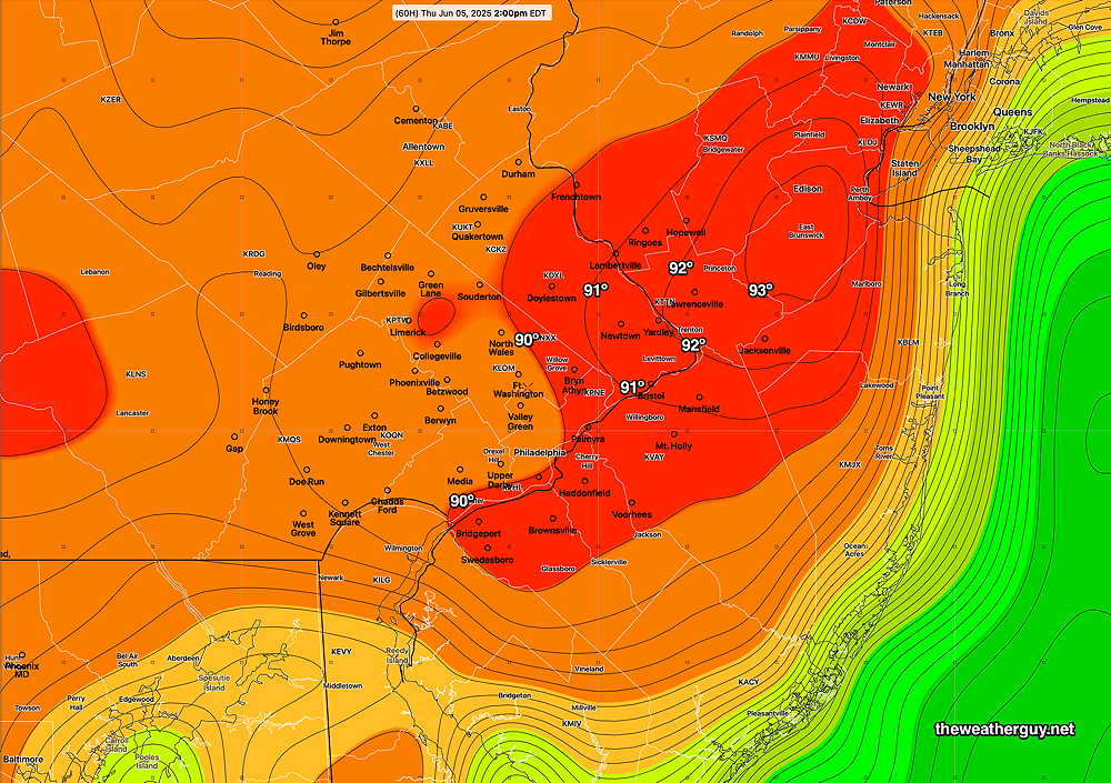
Posted Tuesday 06/03/25 @ 8:25 AM — Looking ahead, there’s some summery weather coming this Thursday, with temperatures likely breaking 90º in some areas.
The latest ECMWF AI model (which gives 6 hour forecasts with 2 PM being the closest to the high temperature time period) shows 90º+ at 2 PM (high temperatures likely about 4-5 PM). Dew points near 63º
ECMWF-AI
ECMWF-AI model high temperature at 2 PM. If correct, the highs for the day (reached at 4-5 PM) will be higher. (Click on image for a larger view.)
The NBM model blend (a statistical ensemble model) is in the same ball park—
NBM high temps forecast for Thursday.(Click on image for a larger view.)
The weekend forecast has high uncertainty with showers/rain Saturday and clearing on Sunday. The weekend forecast hinges on the uncertain position of a stalled front and the uncertain formation and track of a coastal low that’s expected to form.
Tuesday Forecast Update
Posted Monday 06/02/25 @ 5:54 PM — A building high pressure ridge will bring increasingly warm and more humid weather to our area through Friday.
A front will move through late Friday or Saturday with some showers and thundershowers, although the heaviest activity will likely remain north of the immediate Philadelphia area.
Of interest will be a smoke plume from wildfires in Canada that will bring considerably hazy skies. At ground level, smoke increases will be only slight, but perhaps noticeable.
18z HRRR-Smoke model Vertically integrated smoke concentration at 8 PM. Smoke increases during the daytime hours. Red is moderately high, but well short of the levels from several years ago. Luckily, this smoke is aloft, not very much near ground level. (Click on image for a larger view.)
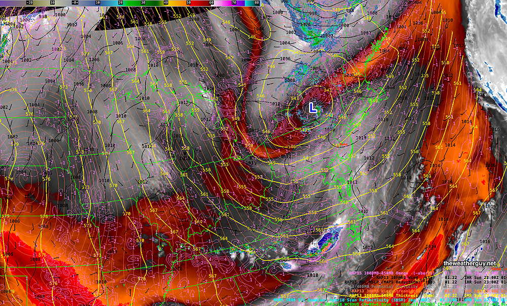
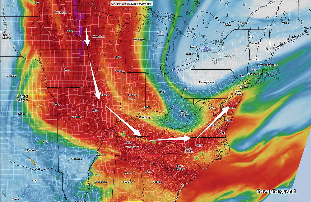
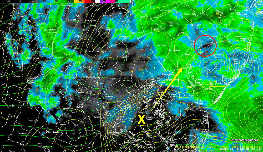
Previously Posted Sun @ 7:40 PM — —An upper air low that is north of our region is expected to move away by Tuesday.
Today it was responsible for more clouds [than had been forecast by many models] and for the cooler than average temperatures. The upper low is visible in the satellite water vapor image—
Water Vapor 7 PM Sunday -Current satellite water vapor image with superimposed RAP model 500-1000 mb thickness lines (yellow), Mean Sea Level Pressure isobars (black contours) potential vorticity (fine violet contours) with superimposed MRMS RADAR. (Click on image for a larger view.)
Also dimming the sun today was smoke from forest fires in Canada. The smoke plumes are rotating around the upper low—
21z HRRR smoke model. Our area was on the fringe of this plume. (Click on image for a larger view.)
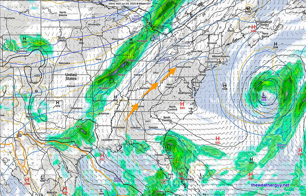
By Wednesday, an upper air ridge will be taking shape over the eastern US, bringing much warmer temperatures on a southwesterly wind flow—
18z GFS forecast for Wednesday morning shows high pressure and and upper ridge in control of our weather. A southwesterly flow of increasingly warm air will bring much warmer temperatures and dry conditions. I suspect that the smoke plume may affect us more this week.
The latest ECMWF-AI model has the cold front (visible on the graphic above) dropping south and likely stalling over our region for late Friday into Saturday. Some showers move in late Friday.
So, a transition period to warmer temperatures and possibly a different pattern looks to be the outlook.
A note for those of you who are visiting this site from “X“. Due to the highly unbalanced political environment on X, I’ve considerably cut back auto-posting there. To receive all of my forecast postings, I recommend following me on mastodon.social or bluesky.social
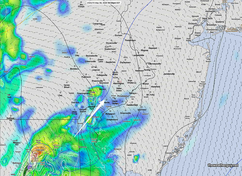
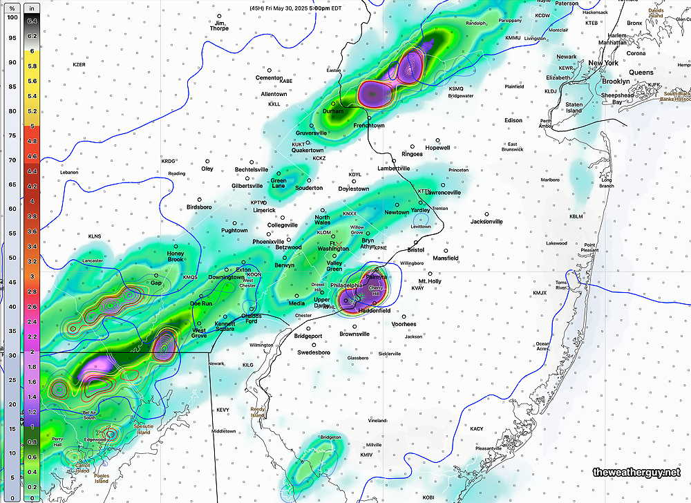
Posted Friday 05/30/25 @ 9:53 AM — The clouds should break for sunshine from west to east about 11 AM to noon. Cloudiness develops again about 4-5 PM. Light rain moves in about 7-9 PM. Heavier rain and possibly severe thunderstorms move in about 9 -11 PM Friday evening, according to the latest HRRR.
Today’s 12z HRRR forecast simulated radar- 10 PM Friday evening. (Click on image for a larger view.)
(Problems with NOAA’s supercomputers have been an issue over the past 18 hours, hopefully resolved. This has prevented availability of the RRFS and REFS.)
Update Thu 5/29 10:44 PM — Tonight’s early models suggest that Friday will be relatively rain free. Minimal isolated showers. Heavy rain and potentially severe storms move in and develop in place over our area beginning 6-8 PM.
Active Unsettled Weather Friday Saturday
Posted Thursday 05/29/25 @ 5:27 PM — Several pieces are coming together for some active weather (heavy rain, thunderstorms) beginning later Thursday night through at least Saturday.
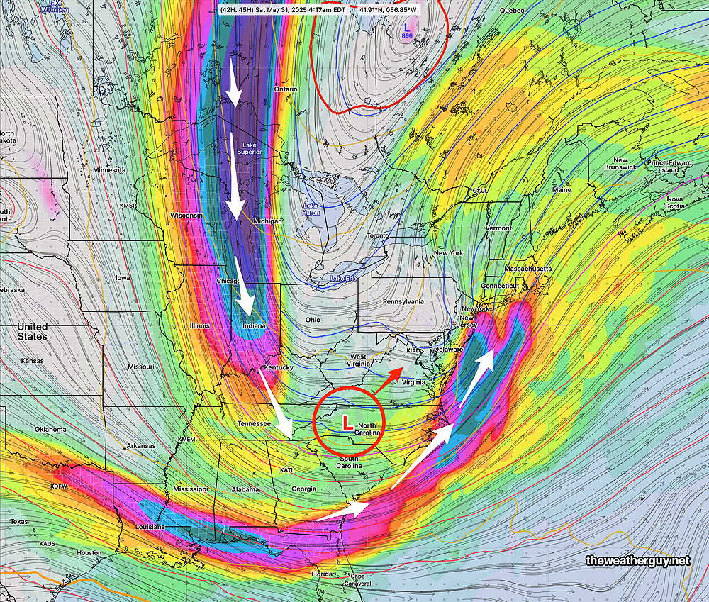
The jet stream is forecast to dive south into a sharp trough (somewhat unusual for late Spring). This feature along with a southern stream jet flow will provide energy to spawn low pressure, rain and thunderstorms. Add to this an increasingly moist air flow with some forecast helicity, wind shear and the ingredients are in place for potential severe weather and heavy rainfall.
Today’s 12z ECMWF jet stream flow shows strong jet streak diving south and interacting with south jet flow, spawning waves of low pressure. (Click on image for a larger view.)
Timing of these soon-to-be spawned low pressure waves will be less than exact. As mentioned, the first wave moves through Thursdaynight with showers and some thunderstorms, ending early Friday morning.
A break in the action looks likely Friday morning, but there’s the possibility of some scattered storms forming Friday afternoon. The heavy action now appears to occur Friday evening and night, where severe thunderstorms are possible, especially in NJ. Rain and thunderstorms continue into Saturday. We may get a break on Sunday.
I expect to hear a few severe thunderstorm announcements over the next two days. Stay tuned.
Clearing Thursday- Possible Severe Storms Friday Afternoon
Posted Thursday 05/29/25 @ 8:42 AM — Sky conditions are expected to improve over this afternoon. Cloudiness will become quite variable in many areas between 2 and 5 PM. Enjoy while you can.
More clouds and what looks like possible severe storms Friday afternoon into Friday evening.
RRFS forecast Precipitation rate and upward helicity at 5 PM Friday. Suggestive of severe storm potential. (Click on image for a larger view.)
Wednesday -Thursday Update
Posted Wednesday 05/28/25 @ 4:33 PM — I rarely use the popular TV weather phrase “I’m tracking this [on radar]” to describe the progression of weather.
“Tracking” suggests to me a very non-dynamic process with weather moving from point A to point B, like on a train track. Indeed, the hourly rain depiction on the iPhone weather widget is that level of weather ‘forecasting’. Weather forecasting is much more complex than this.
Case in point is the current radar, which shows the back edge of the rain moving towards us at 4 PM. So, why did they postpone the Phillies game for this evening?
The reason is rain is expected to redevelop over us and increase in intensity despite the back edge visible on radar at this time.
Composite RADAR with RAP model parameters superimposed at 4 PM. Yellow contours depict vertical velocity. (Click on image for a larger view.)
The above radar image above includes RAP model vertical velocity (yellow X) which is expected to move over us during the early evening hours. Heavier rain is expected to redevelop with this dynamic in place Wednesday evening. (I guess we’ll see if it happens.)
The rain is expected to depart by the early morning, but low clouds will linger for much of the day Thursday.
Another possibly heavy rain maker is forecast to begin mid afternoon Friday.
Wednesday’s Rain
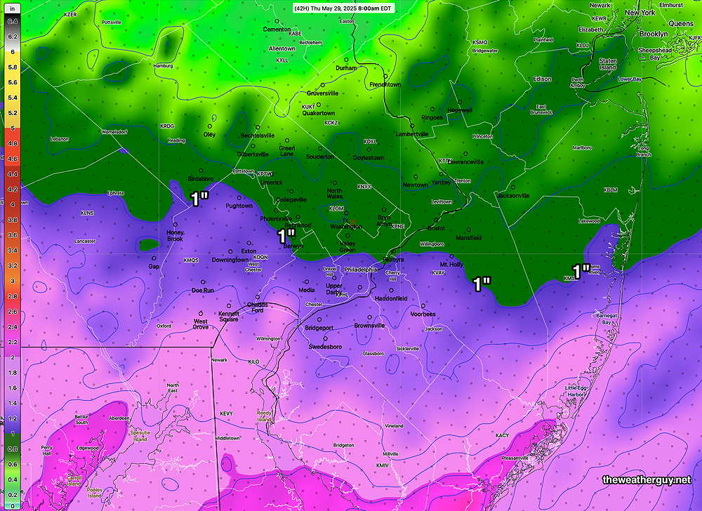
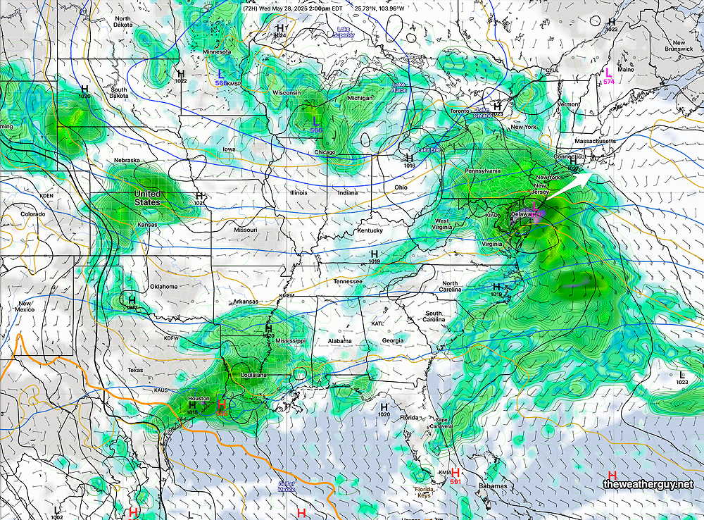
Posted Tuesday 05/27/25 @ 6:10 PM — This afternoon’s models are predicting remarkably similar rainfall totals for Wednesday, with higher rainfall to our south (a trend that has been consistent as well.)
To mix it up a bit, here’s the HREF ensemble model rainfall totals through 8 AM Thursday—
Today’s 18z HREF model rainfall forecast through 8 AM Thursday. (Click on image for a larger view.)
With the exception of the Canadian RGEM, most models have rain starting around daybreak Wednesday. As for the Phillies game Wednesday evening, it looks like the rain doesn’t taper until late evening.
The rain ends early Thursday morning, but plenty of clouds are forecast for much of the day, possibly breaking to some sunshine or bright skies late Thursday afternoon.
Tuesday-Wednesday Forecast Update
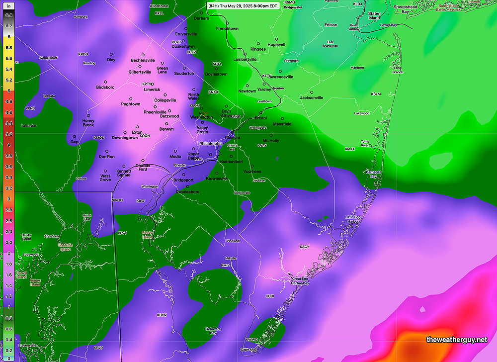
Posted Monday 05/26/25 @ 7:29 PM —It appears that cloudiness will advance earlier into our area Tuesday than previously forecast. Considerable cloudiness is expected during the morning, with thickening and lowering cloudiness during the day.
Many models have some light sprinkles after midnight into early Wednesday morning with heavier rain developing by late morning and during the afternoon. An easterly wind will make it quite chilly on Wednesday.
Rain will continue Wednesday evening and taper off Thursday morning. Slow clearing with a chance of a shower through Thursday.
12z RRFS-A (pre-release version) total rainfall through Thursday/ (Click on image for a larger view.)
The GFS, Canadian, ECMWF and RRFS are forecasting close to 1+ inch of rain total around Philadelphia, less amounts to our north. The AI versions of the ECMWF and the GFS show lesser amounts, about 0.5-0.75 inches with the heaviest rain south of our area.
Memorial Day through Wednesday
Originally Posted Sun 7:53 PM —Low pressure that slowly departed our area will still influence our weather on Monday, Memorial Day. We’ll see plenty of sunshine Monday, but several models are hinting at some cloudiness developing mid-afternoon into the evening as a short wave associated with the departing low rotates through.
The GFS and pre-release RRFS model show the possibility of a few isolated showers between 3 PM and 8 PM. Most areas will be dry. (The Canadian HRDPS keeps these showers far north of our area.) (Updated Sunday 05/25/25 @ 9:12 PM —Several more of this afternoon’s models keep any isolated showers to our far north.)
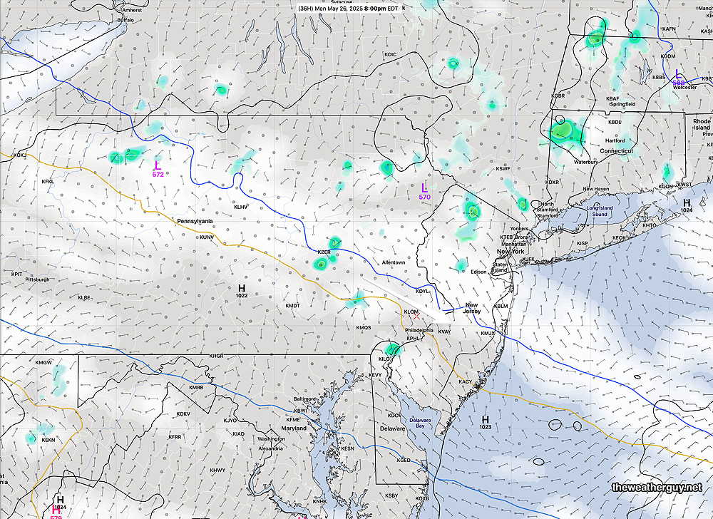
12z RRFS-A (pre-release) model forecast for 8 PM Monday. (Click on image for a larger view.)
Tuesday will have sunshine through high cirrus clouds ahead of an approaching low pressure system. (Areas south of the city and in South Jersey may have considerable mid-level cloudiness.)
Also expected Tuesday is an updated NBM model, which will be moving to NBM version 4.3. This updated model will have several enhancements, including an update to cloud cover and improvements in forecasting tropical systems and severe weather.
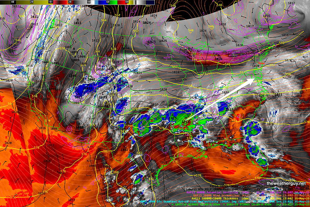
Here’s the storm taking shape in the Central US as of Sunday evening —
Sunday evening satellite water vapor image with superimposed RAP model 500-1000 mb thickness lines (yellow), Mean Sea Level Pressure isobars (black contours) potential vorticity (fine violet contours) with superimposed MRMS RADAR. Storm taking shape in south central US. (Click on image for a larger view.)
This storm will bring rain to our area Wednesday. The trend has been for the heaviest rain to move to the south of our immediate area. About 0.5 inches of rain are expected.
Latest GFS forecast for Wednesday (Click on image for a larger view.)
Posted Friday 05/16/25 @ 4:38 PM — The first short wave moved through around noon. It kept together better than I had forecast. A second short wave will bring showers and thunderstorms here, also a bit later than had been earlier forecast.
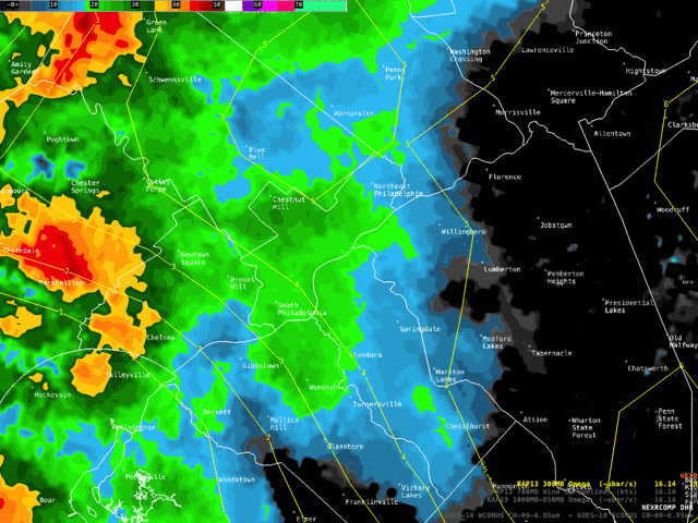
Here’s the current radar at 4:50 PM—
Radar with superimposed RAP model Omega (Click on image for a larger view.)
The HRRR and NAM-NEST have these storms dissipating before getting here between 8 and 9 PM. The RRFS and Canadian HRDPS have the storms moving into our area. I’m leaning towards the RRFS.
Posted Friday 05/16/25 @ 11:45 AM — There’s strong upper level support for the storms currently in western sections, but lower level support is lacking as it moves eastward at 11:44 AM. Let’s see which will prevails.
Radar with upper level RAP model Omega contours at about 11:44 AM (Click on image for a larger view.)
The models are showing less distinction between the original two short waves, now predicting showers and thunderstorms through the afternoon and early evening hours.
Posted Friday 05/16/25 @ 9:06 AM — A quick update. Latest radar shows a bow echo associated with the first of two short waves that will move across our area today.
The current area of fast moving heavy rain rain/ strong storms is expected to weaken as it moves into Philadelphia later this morning. Some rain still possible with this batch. Current RAP model shows moderate downward motion ahead of this impulse consistent with some weakening.
Current composite radar at 9 AM with superimposed RAP model 700 wind streams and low level Omega. Omega is negative in our area, indicating weakening. (Click on image for a larger view.)
Another impulse expected later this afternoon (2-6 PM) will be fueled by higher CAPE values and higher vertical wind shear. Some stronger storms expected with this second short wave. I’ll update around noon with newer models.
Revised ForecastPosted Thursday 05/15/25 @ 7:40 PM — After reviewing the afternoon (18z) models which became available after my previous posting, I have to revise my forecast.
It appears that there will be two waves of energy that pass through on Friday. The first, in the late morning, will be strong in far western areas, but several models have this rapidly diminishing in intensity as it encounters a weak mid-level ridge over Philadelphia.
A second impulse moves through between 2 and 5 PM, as noted below, which appears to have more mid-level support, causing some very strong storms as it moves into NJ. We’ll see how it all plays out. I’ll update tomorrow morning.
Posted Thursday 05/15/25 @ 5:15 PM — A potent disturbance will move through during Friday afternoon. Previously expected around noon, the latest models have it moving through about 2-5 PM, earlier to our far west.
The upper air will support strengthening as it approaches, but it’s forecast to hit a weak mid-level ridge right over Philadelphia. Some models (HRRR) have it weakening and moving to our north and south over this ridge. The latest RRFS (experimental) maintains some of its strength and has it further intensify as it makes it across the river into NJ.
So this disturbance (called a “short wave”) is not looking as intense as it was yesterday, but some of the thunderheads may reach 50,000 feet according to the RRFS with fast onset heavy rains and winds.
RRFS 700 mb (10,000 feet) level short wave and Relative Humidity (shading) at 10,000 feet. Not shown are CAPE values which are in the 1000-1500 joule level and areas of vertical shear which exceed 25 1/sec. All the ingredients for storm formation. (Click on image for a larger view.)
The weather clears for Saturday, but a few widely scattered late day thunderstorms still possible.
Thu 5:11 PM —Forecast Review — We had the sun break out about mid afternoon, as forecast. Some areas, especially in New Jersey have been seeing some showers and low level thunderstorms.
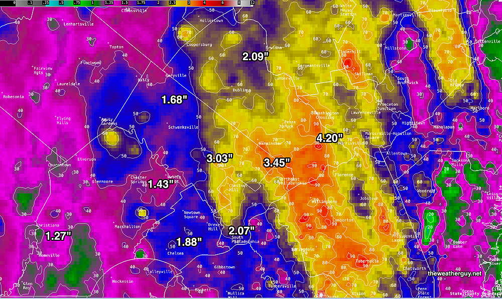
We’ve had quite a bit of rain over the past three days. Here’s a final summary, based on the MRMS—
MRMS rain-gauge measured rainfall combined with rain-gauge calibrated and interpolated radar-based summary of ACTUAL RAINFALL RECEIVED over the past 72 hours. . Color shading is in inches. Line contour numbers are in mm. (25.4 mm= 1 inch) (Click on image for a larger view.)
Thursday through Friday
Posted Wednesday 05/14/25 @ 5:28 PM —Following some scattered showers Thursday morning, many of us may finally see some sun Thursday by mid afternoon. Unfortunately the upper air will be cold and thermal instability will lead to scattered showers and thundershowers between 2 and 6 PM. A mix of clouds. sun and scattered storms sums it up for the afternoon.
Friday, a strong impulse rotating around the upper low near the Great Lakes will result in potentially some strong fast moving storms here around noon. Here’s the RRFS, which suggests a bow-echo formation around noon—
12z experimental RRFS simulated radar forecast for noon Friday.
The potential for damaging winds Friday with this impulse needs to be watched.
Wed 5:20 PM —Forecast Review —The experimental RRFS did better than the HRRR today regarding its forecast for lingering moisture and rain around Philadelphia this afternoon.
Posted Wednesday 05/14/25 @ 12:14 PM — Opted against going to the afternoon Phillies game. The morning models support a dry slot developing, and current radar/water vapor imagery shows dry slot advancing northward—
Satellite Water Vapor with superimposed composite radar at noon. (Click on image for a larger view.)
The hold-out for improving conditions is the experimental RRFS. It still shows some showers during the afternoon game. (Perhaps we’ll see why it’s still ‘experimental.)
14z experimental RRFS simulated radar at 2 PM. Could this be right?? (Click on image for a larger view.)
What about the Phillies Games today?
Posted Wednesday 05/14/25 @ 9:10 AM —It does look like there will be a relative ‘dry slot’ develop beginning about 2-3 PM today in the city. The latest HRRR (11z) shows rain exiting to the northwest.
Here’s the simulated radar forecast for 1 PM. There may be some showers at the scheduled game start—
11z HRRR simulated radar forecast at 1 PM As we always see, exact placement of forecast rain is more frequently than not inaccurate. (Click on image for a larger view.)
The latest HREF model, which is a statistical ‘ensemble’ of the HRRR, NAM-NEST and RAP models shows minimal rain for the hour preceding 2 PM —
06z HREF forecast 1 hour prior rainfall at 2 PM. (Click on image for a larger view.)
Additional rain is expected during the evening, but the models are leaning towards it being somewhat west of the city.
As for total rainfall so far for this event, this has been the most significant widespread rainfall we’ve had in a long time. Here’s the latest 48 hour total estimate—
MRMS rain-gauge measured rainfall combined with rain-gauge calibrated and interpolated radar-based summary of ACTUAL RAINFALL RECEIVED. Color shading is in inches. Line contour numbers are in mm. (25.4 mm= 1 inch) (Click on image for a larger view.)
Wednesday Forecast Update
Posted Tuesday 05/13/25 @ 5:19 PM — The weather is unfolding as forecast, with a stream of increasingly heavy showers moving up from the south southeast around a closed upper low to our west.
The latest ECMWF-AI model has rain continuing tonight and becoming quite heavy by early morning Wednesday. Some thunderstorms may be in the mix on Wednesday. A total of almost 2″ of much needed rain is forecast for our area through midnight Wednesday.
ECMWF-AI forecast for 2 PM Tuesday. Heavy rain over our area. (Click on image for a larger view.)
It looks like some rain/showers continue on Thursday as the upper trough axis moves over us. Thunderstorms also possible.
Tuesday Forecast Update
Posted Monday 05/12/25 @ 5:56 PM — The forecast appears to be generally on-track with rain expected in the immediate Philadelphia area on or before 5 AM Tuesday morning.
Here’s the current satellite water vapor image—
Current satellite water vapor image with superimposed RAP model 500-1000 mb thickness lines (yellow), Mean Sea Level Pressure isobars (black contours) potential vorticity (fine violet contours) with superimposed MRMS RADAR. Upper level low (L) will gradually move north-northeast. Bands of rain will rotate up over our area at least until late Wednesday and likely into Friday. (Click on image for a larger view.)
Light showers to start, then bands of heavier rain move in later in the morning and continuing, with some breaks, through the afternoon and Tuesday night. Rain tapers off somewhat on Wednesday, but thundershowers will likely develop during the afternoon.
Total rainfall around 1 inch possible in and around Philadelphia, by Wednesday morning. more west of the city.
Posted Monday 05/12/25 @ 7:40 AM — This week’s model forecasts continues to evolve, with a shift towards some heavier rain in the immediate Philadelphia area by Wednesday. (I’ll have to see it to believe it.)
For today, sunshine through high cirrus clouds, with clouds thickening between 4 PM and 7 PM from southwest to northeast. Rain begins here before daybreak Tuesday, but much of the rain will be showery in the morning.
The chance of more moderate to heavy rain waits until later on Tuesday and most likely Tuesday night into Wednesday morning.
06z REFS (experimental( shows only light rain likely here at noon on Tuesday. At least initially, the heaviest rain will be west of our area. (Click on image for a larger view.)
Originally Posted Sun 8:17 PM —Monday will have sun through high clouds, then increasing cloudiness by 4PM. High temps similar to Sunday, near or just above 80º. Rain begins after midnight early Tuesday morning.
An active weather week ahead, where another upper level closed low will bring good chances for rain from before daybreak Tuesday through Friday.
Despite this forecast, it’s not entirely clear whether the needed heavier rain will be in and around Philadelphia, or continue a long standing pattern for the heavier rain to remain to our far north and west. Some models are showing heavier banding right over Philadelphia, but others (Canadian and various runs of the German ICON model and the RRFS) show the heaviest rain to our far northwest.
The latest GFS shows this west-northwest trend—
Today’s 18z GFS model forecast total rainfall through daybreak Wednesday. Greater accumulations by Friday. (Click on image for a larger view.)
Some models show just intermittent showers on Tuesday, while others are forecasting periods of moderate, continuous rainfall here. Too early to be sure.
There will also be the possibilities of thunderstorms during the week; the higher dew points, available moisture aloft and instability will set the stage for these storms, especially late afternoons and evenings.