Category Archives: Philadelphia Weather Outlook

THIS WEEK’S WEATHER

#Philadelphia #weather #PAwx

Friday Quick Update

Posted Friday 03/01/24 @ 10:34 AM — The high layer clouds probably won’t move in until after 4-5 PM today, Friday.

Very rainy Saturday with latest models increasing the rainfall amounts to 0.6- 1″ of rain here.

There may be some periods of sun Sunday morning.


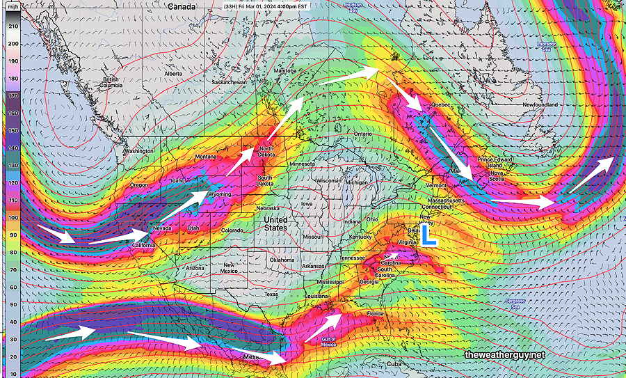
Friday and the Weekend Early Outlook

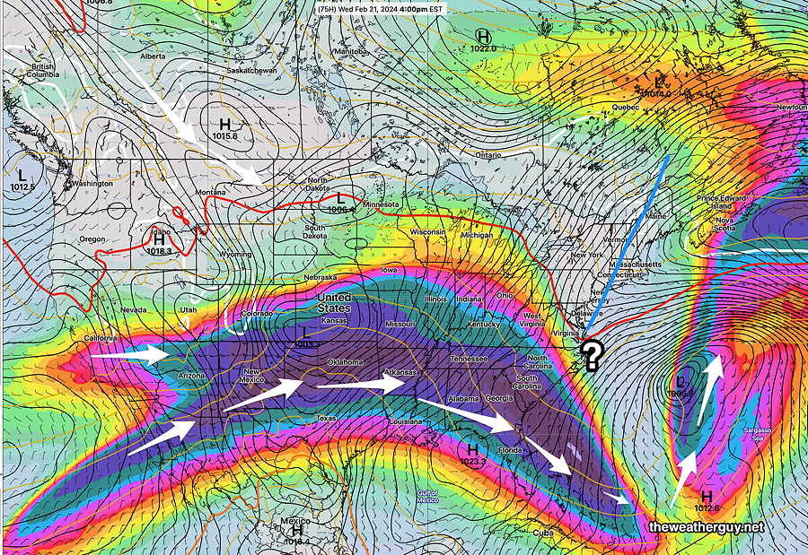
Posted Thursday 02/29/24 @ 5:10 PM — A complicated and split jet flow will result in a weak, slow moving coastal low near our area from Friday into the weekend—

02-29-24 12z NAEFS winds at 250 mb (jet stream level) shows the southern and northern branches of the jet stream winds. The interaction of the two streams as well as blocking high pressure in the Atlantic will spawn a coastal low (L) from an inverted trough . Light rain and an easterly flow will result on Saturday. Clouds move in later Friday. (Click on image for a larger view.)

Friday will start sunny, but very high clouds move in from southwest about 1-2 PM and cloudiness increases slowly during the late afternoon. Plenty of sunshine expected through these high clouds for much of the day. Highs 48º-51º

NAEFS forecast for Saturday at 4 PM. (Click on image for a larger view.)

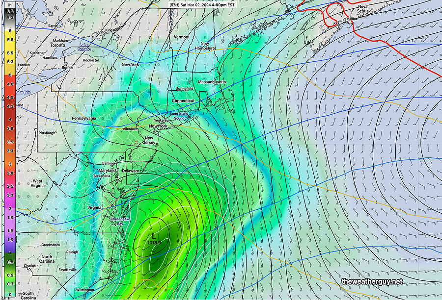
Saturday looks to be cloudy, damp with rain at times during the day. Despite the low clouds, temperatures will be in the low 50s.

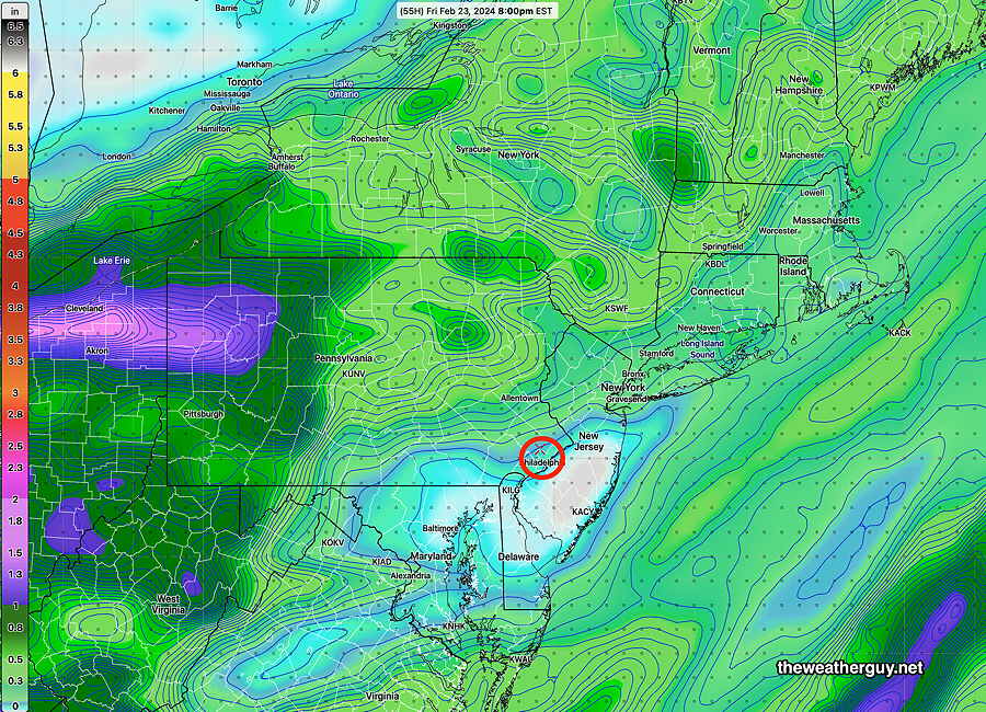
Most models have our rainfall in the 0.3″-0.6″range, but the NAM has been consistently forecasting heavier rain on Saturday.

Sunday dries out but a significant cloud cover may remain. Very mild with highs in the low 60s.


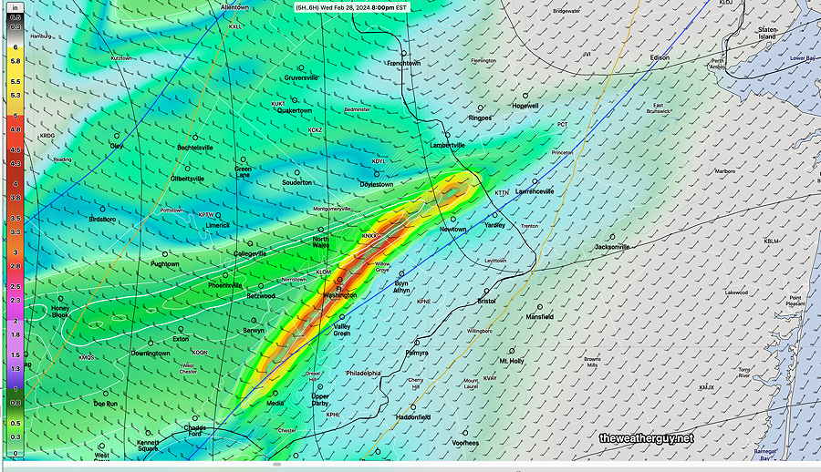
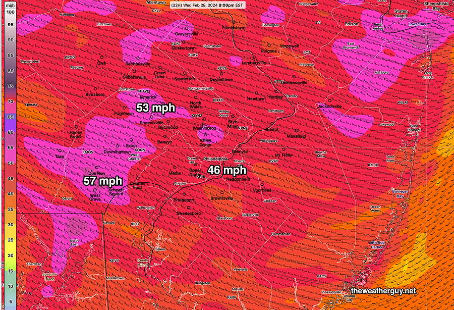
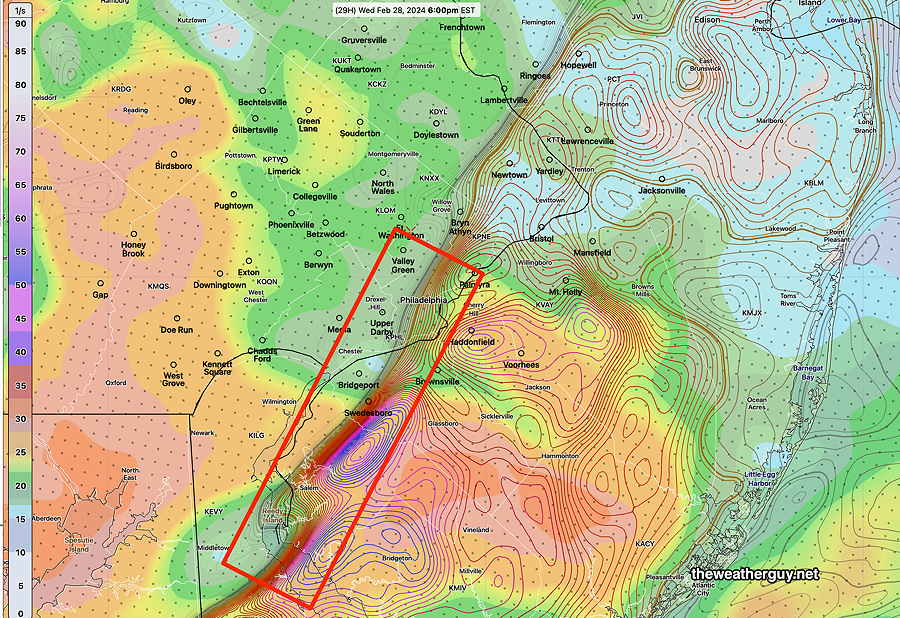
Wednesday Evening Storm Update

Posted Wednesday 02/28/24 @ 5:32 PM — The winds are beginning to pick up and the latest HRRR from 4 PM (the HRRR model is run hourly and takes about 1:20 hours to complete) shows a line of very heavy rain moving through about 8 PM—

02-28-24 20z HRRR (4PM EST model) shows a line of heavy rain at 8 PM. High winds/gusts with this line and afterwards. Above is precipitation and “precipitation rate”. The winds will stay elevated as temperatures drop rapidly. (Click on image for a larger view.)

Wednesday Storm Update

Posted Wednesday 02/28/24 @ 11:22 AM — The cold front is entering northwestern Pennsylvania and several lines and areas of showers precede the front.

Current satellite water vapor image with superimposed RAP model 500-1000 mb thickness lines (yellow), jet level wind streamlines (orange contour-arrows) potential vorticity (fine violet contours) and superimposed MRMS radar. (Click on image for a larger view.)

The trends from the latest HRRR- heaviest rain between 5:30 PM and 9 PM. Wind gust forecast is now in the 40-45mph range and continues behind the front.


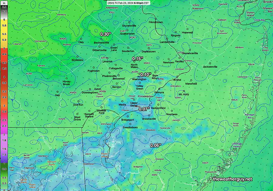
Posted Wednesday 02/28/24 @ 8:46 AM — The forecast remains basically on track. Most areas received about 0.15- 0.20 inches of rain last night. As expected, greater amounts fell far northern Bucks County and northwestward into Allentown.

We may see some bright skies for a period later this morning. More showers will following.

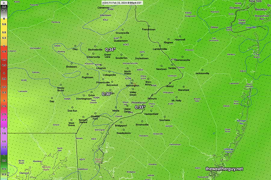
The models are forecasting an additional 0.50- 0.80 inches of rain in our immediate area. This morning’s HRRR just available shows diminished shear and helicity values from last night’s extreme values.

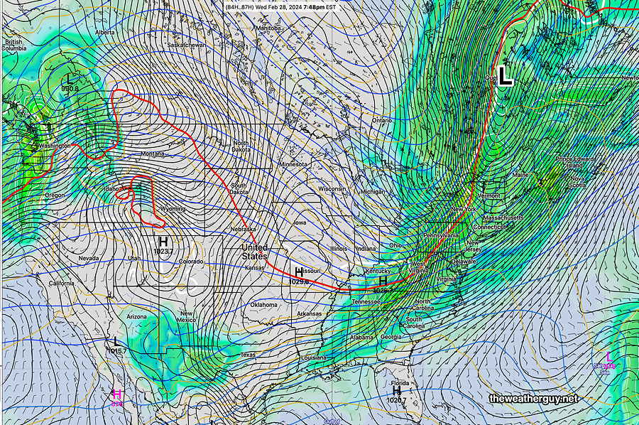
The big impact will be the winds and the plummeting temperatures. The HRRR is still forecasting wind gusts in excess of 50 mph. The Canadian HRDPS interestingly, shows the high winds following the frontal passage, not so much with the rain and front.

The heaviest rain will be with the front, between 5:30 (western sections) and 8 PM.


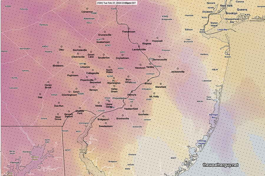
More on Wednesday’s Storm

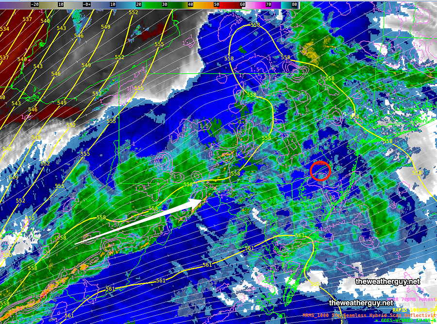
Posted Tuesday 02/27/24 @ 7:47 PM — We’ll have several periods of rain on Wednesday. With the cold front moving through between 7-9 PM, expect the possibility of strong, damaging winds especially between 5 PM and 9 PM.

A further review of this afternoon’s models suggests that despite a lack of CAPE, helicity and vertical shear values are predicted to be so high during these hours that strong thunderstorms can’t be ruled out.

Basically, the available high kinetic energy (helicity/shear) makes up for any lack of thermodynamic energy (CAPE) for spawning these storms.

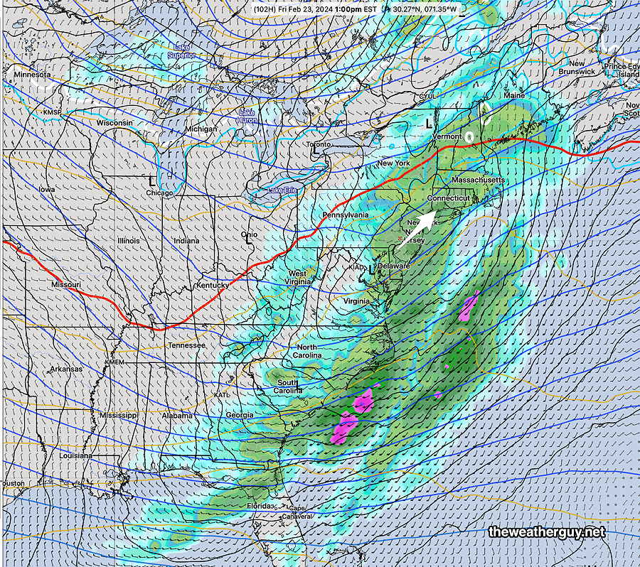
Here’s the HRRR wind gust forecast for 9 PM—

02-27-24 18z HRRR wind gust forecast for 9 PM Wednesday. Exact location and timing of maxima are not to be relied on. (Click on image for a larger view.)

Of greater interest is the severe weather parameters, vertical wind shear and helicity that peak in serious way about 6 PM. The last time I saw these values, we had some tornadic activity. With a lack of CAPE, I’m not really sure what to make of it—

02-27-24 18z HRRR forecast Shear (shading) and Helicity (contours). Helicity values are approaching 900 m2/s2 in the boxed area which is extremely high. If CAPE were forecast to be higher, tornadoes would be likely. Without CAPE, I’m not sure what to expect. (Click on image for a larger view.)

I’ll update this evening if anything else shows up in tonight’s early models. I think we need to wait for tomorrow morning for the final call.


Stormy Wednesday

Posted Tuesday 02/27/24 @ 6:03 PM — While the wonderful mild temperatures have gotten most of the attention on the TV/radio, the real story will be the rather significant storminess on Wednesday afternoon and evening.

A sharp cold front will move through about 6-9 PM Wednesday evening. Plenty of dynamics has been expected but the latest models have increased the possibility of some wild weather here.

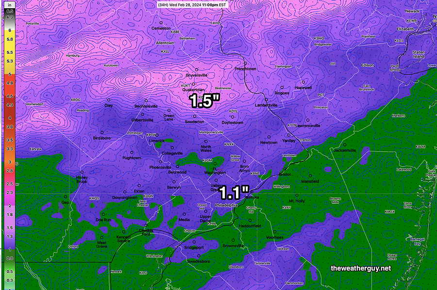
What had been expected to be a light rainfall is now in the heavy 1″- 1.5″ range with locally higher amounts.

Over the past several days, I’ve been talking about the high winds expected and the latest models are supporting sustained winds of over 25 mph with gusts 40-50 mph. While thunderstorms are not likely (according to the NBM) with low CAPE values, there’s plenty of wind shear and helicity to fuel some of the downpours. ( We’ll have to see if thunderstorms can form with such low expected CAPE).

NBM total rainfall through 11 PM Wednesday night. (Click on image for a larger view.)

Temperatures will plummet from the upper 50s to below freezing in about 6-8 hours after midnight Wednesday.

More details follow with tonight’s early models.


Tuesday- More Sunshine

Posted Tuesday 02/27/24 @ 8:54 AM — Last night’s models have pretty much converged on a later start for the showers instead of early afternoon. It appears that showers will hold off until about 4 PM (western areas) to 7 PM as forecast yesterday by the HRRR and Canadian models.

Regarding cloud cover, it appears that we’ll see an increase in cloudiness towards noon, but breaks of sun and clouds will remain with us through about 3 PM, at which time the lower level clouds move in.

02-27-24 06z Experimental RRFS-Ensemble cloud forecast at 2 PM. (tan- high cirrus, maroon- mid level clouds) (Click on image for a larger view.)

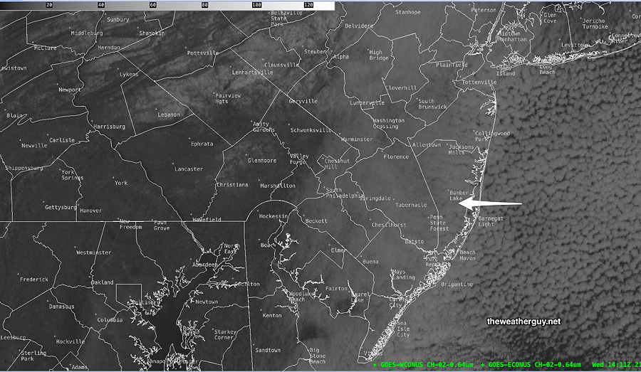
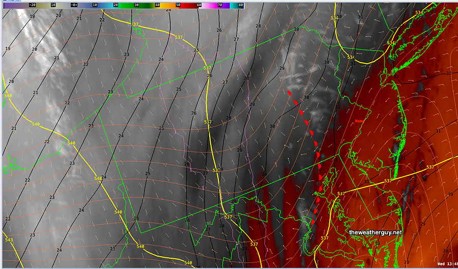
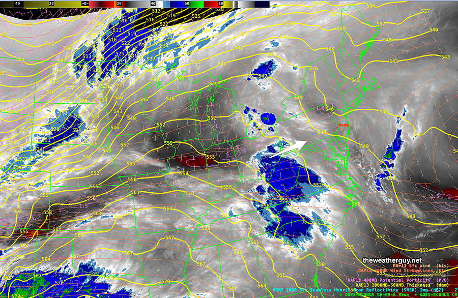
Current Water Vapor image—

Current satellite water vapor image with superimposed RAP model 500-1000 mb thickness lines (yellow), jet level wind streamlines (orange contour-arrows) potential vorticity (fine violet contours) and superimposed MRMS radar. (Click on image for a larger view.)

Tuesday Forecast Update

Posted Monday 02/26/24 @ 8:00 PM — This afternoon’s models show a change in the forecast for Tuesday. Some, but not all, models are now showing an earlier start to the showers.

Tuesday starts sunny, but clouds move in rapidly about noontime from the west. Several models (GFS, HREF, NBM, ECMWF and ICON) have light showers moving in as early as 1-3 PM. (The experimental RRFS shows showers 4-5 PM and the HRRR and Canadian models about 6-7 PM.)

I’m going with the earlier start time (1-3PM) for the showers since the GFS tends to be better with timing these things.

Despite the clouds, the NBM is still predicting fairly warm high temperatures—

02-26-24 18z NBM forecast high temperatures for Tuesday. Fine contours are 1º increments. (Click on image for a larger view.)

As mentioned, a sharp cold front will move through Wednesday evening with rain and likely high winds. It doesn’t appear that thunderstorms will be part of the mix. Rainfall for the immediate Philadelphia area is running about 0.6-0.8″ of rain. Not the biggest rainstorm for us compared to recent others.

The big story will be the wind and wind gusts above 40 mph and sharp drop in temperatures Wednesday night behind the front. I realize that lately, some of the model forecasts for high winds just haven’t been materializing. This time around I think it’s a good bet.


Initially Posted Sun 5:28 PM —

A roller coaster experience of weather will unfold this week, beginning with the overnight period tonight (Sunday night). An upper air trough will move through along with a front before daybreak Monday with widely scattered showers, mostly north of the city. (It’s hard to believe since there isn’t a cloud in the sky as I write this. )

A well-advertised warm up is expected Monday through Wednesday. But an abrupt end to the warmup is expected later Wednesday as a strong cold front moves through and the temperatures drop almost 30 degrees after midnight into Thursday.

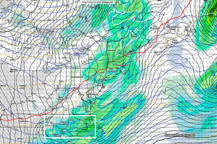
Here’s the current water vapor image on Sunday afternoon—

Current satellite water vapor image with superimposed RAP model 500-1000 mb thickness lines (yellow), jet level wind streamlines (orange contour-arrows) potential vorticity (fine violet contours) and superimposed MRMS radar. Two large disturbances in separate jet flows (1) (2) will combine their energy into an energetic trough by Wednesday. (Click on image for a larger view.)

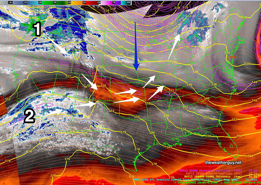
Here’s what unfolds later Wednesday—

02-25-24 12z NAESF forecast for Wednesday evening. A sharp cold front moves through with rain, possibly some thunder and very strong winds. Temperatures in the 60s drop to near freezing Thursday morning. (Click on image for a larger view.)

The very warm temperatures have talked about, but there’s been little attention to the sharp front and possible stormy weather later Wednesday. I’ll have more coverage as the week progresses.

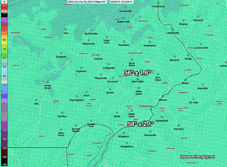
Monday — Following scattered showers before daybreak, clouds in the early morning becoming sunny by mid to late morning. Here are the NBM high temps—
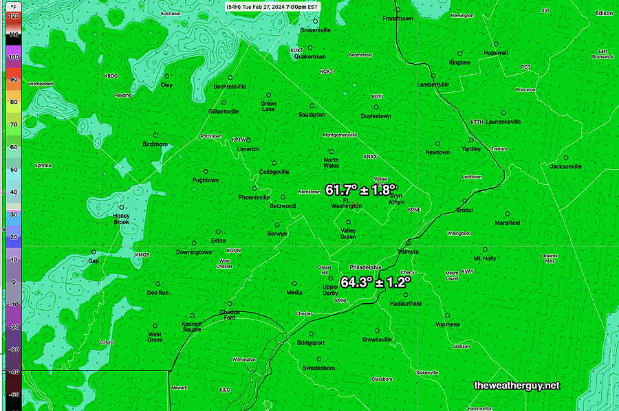
02-25-24 18z NBM forecast high temps for Monday with standard deviation. (Click on image for a larger view.)

For Tuesday

02-25-24 18z NBM forecast high temps for Tuesday with standard deviation. (Click on image for a larger view.)

By late Tuesday, some rain may move in. Wednesday will be warm, but with showers.

Sun 05:37 PM Update — As soon as I posted this forecast, the latest GFS model shows the front comes through during the late afternoon Wednesday instead of around midnight. An evolving forecast.

The interesting weather begins late afternoon Wednesday. Stay tuned for updates.


THIS WEEK’S WEATHER

#Philadelphia #weather #PAwx

Thursday – Friday Outlook

Posted Thursday 02/22/24 @ 9:54 AM — Clouds will be on the increase later this morning and it should be mostly cloudy by early afternoon. Light showers expected to move in from the west between 5 PM and 7 PM tonight.

There’s still a trend for the rainfall to be on the light side. The latest model blend shows these amounts—

02-22-24 12z NBM model blend – total rainfall through Friday. (Click on image for a larger view.)

NOAA’s new model under development, the still-experimental RRFS, has show some big advances in its development over the past month with its own data inputs and some advances to its ensemble version. Just to see, here’s the current RRFS -Ensemble total rainfall forecast —

02-22-24 06z RRFS Time-Lagged Ensemble Model total rainfall (Click on image for a larger view.)

It looks like light rain/drizzle lingers into mid afternoon Friday, with some clearing before sunset Friday.

The weekend looks cold, although somewhat less so on Sunday.


Posted Wednesday 02/21/24 @ 7:06 PM — Sometimes the latest models are not the best in forecasting the immediate upcoming 6 hours. Such was the case with this morning’s HRRR and NAM-NEST which forecast more clouds than we had. Forecasting can be a challenge, even if supported by satellite imagery.

As for Thursday, clouds moving in ahead of a system to our west will have Thursday becoming increasingly cloudy. By late morning it will be mostly cloudy. The models are fairly consistent forecasting some very light rain moving in by 5 -7 PM. There’s a wide spread in forecast high temperatures: 46º – 48º ± 2.6º.

The big question continues to be the amount of rain that will fall here in the immediate Philadelphia area Thursday night through early Friday. There’s tremendous model differences, with the majority of the models having most of the rain bypassing our area to our north and south. The amount of rain forecast varies from a few hundredths of an inch to almost about 0.60″ inch of rain. The NBM (model blend) falls in the the low range of about 0.20″.

Here’s the latest GFS rainfall forecast. The Philadelphia area is in a doughnut hole—

02-21-24 18z GFS accumulated rain forecast by Friday evening (Click on image for a larger view.)

As was the case with today’s cloud cover, the models are having difficulty resolving the current weather pattern. As was the case yesterday, I expect further changes in the forecast.


Wednesday Update

Posted Wednesday 02/21/24 @ 9:24 AM — A change in the forecast. The low pressure system in the Atlantic, originally expected to bring some cloudiness only to eastern NJ has pushed moisture further west. This morning’s HRRR and NAM-NEST show cloudiness pushing westward. The latest visible satellite image—

Visible Satellite image 9 AM today (Click on image for a larger view.)

On water vapor imagery, a wind change line has set up, which I’ve drawn in as warm front. East of this line, we’ll have increased cloudiness—

Water Vapor image this morning. (Click on image for a larger view.)

So today looks to have more cloudiness, with sunshine through high and mid level clouds, than previously forecast especially from just west of the city and eastward.

As alluded to yesterday, I expect to see forecast changes over the next day or so. The second system in the Atlantic is probably complicating the model forecasts.


Wednesday – Friday Outlook

Posted Tuesday 02/20/24 @ 7:50 PM —— Continued near -seasonable temperatures Wednesday with highs in low 40s with plenty of sunshine.

Things warm up a bit on Thursday, but with clouds moving in early afternoon. Highs in the mid to upper 40s. Rain should wait until late evening, but there have been some hints that we may see it start earlier.

There’s still some uncertainty about the rain expected late Thursday evening into Friday. Most models have very light rainfall for our area (0.20″), but there have been some model runs that crank out much more (0.60″)

The GFS has the rain ending by noon, but the NBM shows light rain showers lasting into Friday afternoon, perhaps from another low that forms along the cold front —

02-20-24 18z GFS shows weak low pressure over our area Friday noontime with much of the rain missing us. I’m just not yet convinced of this. There’s plenty of ‘bagginess’ in the isobars (white box) that often suggests formation of another low. (Click on image for a larger view.)

It would not surprise me if the light rain forecast for Friday changes in the coming days. Regardless, plenty of wind is expected later Friday afternoon.


Tuesday-Thursday Outlook

Posted Monday 02/19/24 @ 7:37 PM — There’s been clarification with the forecast for this week. We’ll be mostly sunny Tuesday through very early Thursday. (Some clouds from large storm system in the western Atlantic may spill back into NJ on Wednesday.) Temperatures will approach 50º by Thursday.

Low pressure approaches on Thursday. Thursday will have increasing cloudiness with rain moving in from the west as early as late afternoon or early evening. It will be rainy on Friday. It’s not clear how strong the storm will get on Friday. The ECMWF has only 1/2 inch of rain falling from this system—

02-19-24 12z ECMWF forecast for Friday at 1 PM. Low pressure moves almost over us and the northeastward. No cold air in place with the freeaing line (white contour) in Canada! (Click on image for a larger view.)

Previously Posted Sun 9:17 PM —

Quiet weather is expected the early part of this week and the thought was there would be a general moderating trend in temperatures by Wednesday or Thursday. Looking at the latest NAEFS, however, I’m seeing large forecast changes from previous model runs in the overall jet level pattern, especially by Thursday.

More so, the coast storm that was expected on Friday may not develop as previously forecast.

Frankly, the current forecast upper air map is a bit confounding.

Here’s the NAEFS jet level forecast for Wednesday—

02-18-24 18z NAEFS jet level and surface level combined forecast for Wednesday at 4 PM. Developing warm upper ridge in the center of the country doesn’t make big progress into our area with a persistent trough (blue diagonal line) over the coastal northeast hanging tight through Wednesday. It may reach us by Thursday. Low pressure forecast over Kansas may not trigger coastal development near the question mark.

So, until things clarify, I don’t have my usual big picture summary of the coming week’s weather. Right now, I think we can safely forecast through Tuesday. And maybe expect some milder weather by Thursday.

For Monday we can bank on sunny skies.

Tuesday will be sunny in the morning with some high clouds later in the afternoon as a warm front tries to approach.

For the rest of the week, we’ll have to wait to see if the warm front makes it here and we’ll have to determine what will happen with the low pressure system. Some time next weekend looks colder again.