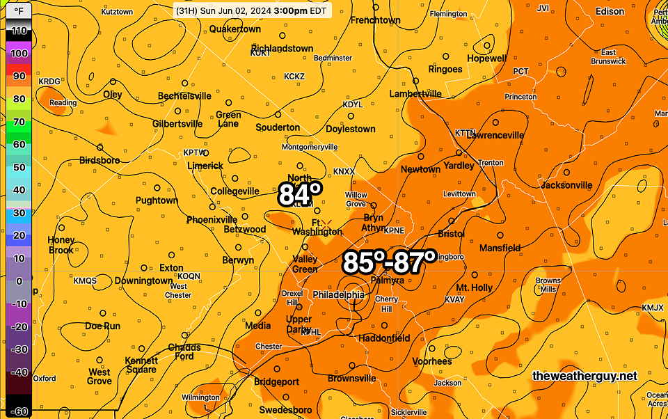
Sun 6:48 PM —Forecast Review — The REFS high temperature forecast was way too warm today. The official high was 84° in Philadelphia. I suspected that might be the case. The REFS isn’t ready for prime time.
Posted Sat, 06/01/24 @ 7:19 PM— It appears that temperatures may be a little higher on Sunday than forecast yesterday. For a change of pace, I’m going to post the experimental REFS instead of my usual NBM model. The REFS is forecasting in the upper range of the NBM model’s temperature spread, but the NBM often runs a bit too cool.
Today’s 12z REFS model forecast temperatures at 3 PM. (Click on image for larger view.)
The experimental REFS is the ensemble version of the experimental RRFS. Being an ensemble, it consists of the mean (average) and statistical spread (standard deviation) of a group of models or variations of models. In the REFS case, the group of models consists of time-lagged versions of the RRFS and HRRR and perturbations of these same models.
There’s still a fair amount of clouds and sunshine through clouds forecast for Sunday, so we’ll see if these high temps are forecast too high.
Previously Posted Fri 3:30 PM —High pressure will gradually move off the coast Saturday through Sunday. A system to our west will be slow to move in, keeping our area dry over the weekend.
Much of next week looks somewhat unsettled.
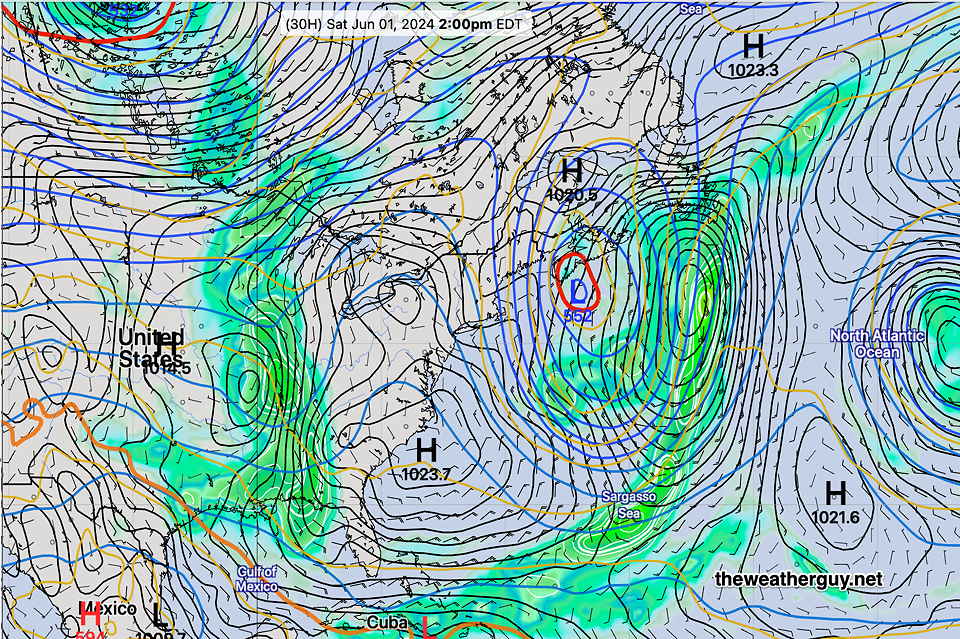
NAEFS forecast for 2 PM Saturday. High pressure off the coast will keep fair skies for Saturday. The system in the Midwest will bring some high clouds for Sunday. (Click on image for larger view.)
Saturday
Sunny and pleasant. High 81-83º (average uncertainty)
Sunday
Sunshine through a thickening layer of high cirrus clouds. Light scattered showers will likely wait until evening or night time. High 83-85º (higher than average uncertainty due to cloud cover)
Posted Friday 05/31/24 @ 9:13 AM — The latest model runs have backed off on the light showers that had been expected to move in during the day on Sunday. It now appears that we’ll have gradually increasing clouds and any light showers, if any, won’t move in until early Sunday evening.
The latest ECMWF , which had been quite aggressive with the rainfall Sunday evening, has joined the latest GFS with little in the way of rainfall—
Saturday we’ll get into the low 80s (81-83º) and Sunday (82-84º) Due to the cloud cover, there’s a bit more uncertainty regarding high temps on Sunday.
Delightful through Saturday
Posted Thursday 05/30/24 @ 9:42 AM —The cold front moved through last night and unseasonably cool delightful weather will be with us through Saturday.
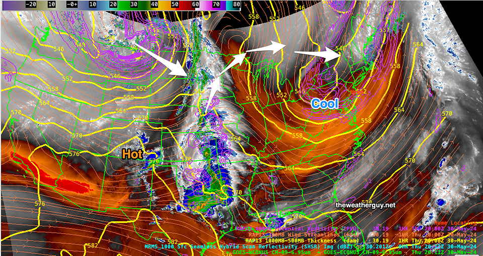
Current water vapor imagery shows the air mass over our area and the disturbances setting up to move in sometime Sunday—
Water Vapor image with superimposed RAP 500-1000mb thickness (yellow), jet stream winds and potential vorticity (violet)(Click on image for larger view.)
The big question is the timing of the next system on Sunday. Current trends are for it to be cloudy with light showers possible in Philadelphia Sunday afternoon. The light showers may arrive at the shore later in the evening.
Gusty Showers/Thunderstorms Wed Evening
Posted Wednesday 05/29/24 @ 8:39 AM — A cold front associated with an upper and surface trough will move through this evening.
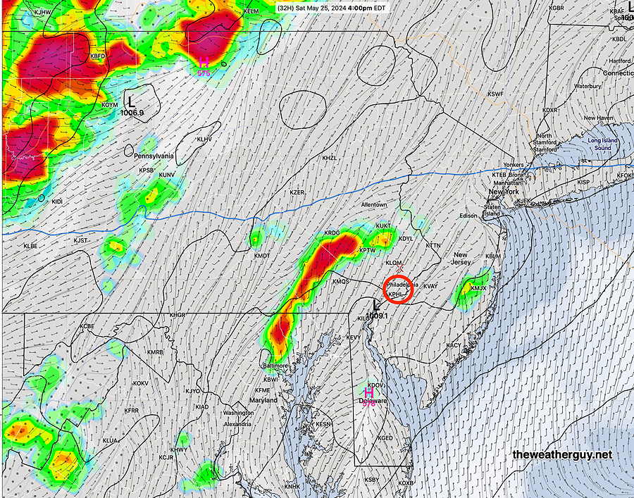
The models have come together with a time frame of 6-8 PM, earlier southwest Chester county, for showers and embedded thunderstorms to move through. Some locations will receive an inch of rain, while adjacent areas less than a quarter of an inch. So the heavier rain will be spotty and localized. The heaviest rain is expected northern Bucks county and north of Allentown, as well as north central NJ.
The experimental RRFS model didn’t do bad for last Sunday’s rainfall. Here’s the RRFS total rainfall forecast for this evening—
Today’s 06z RRFS model (experimental) total rainfall forecast for Wednesday evening (Click on image for a larger view.)
As mentioned yesterday, the storms will move in from the southwest with gusty winds, which appears to be the main potential hazard. Truly severe weather not expected.
Skies clear by daybreak Thursday.
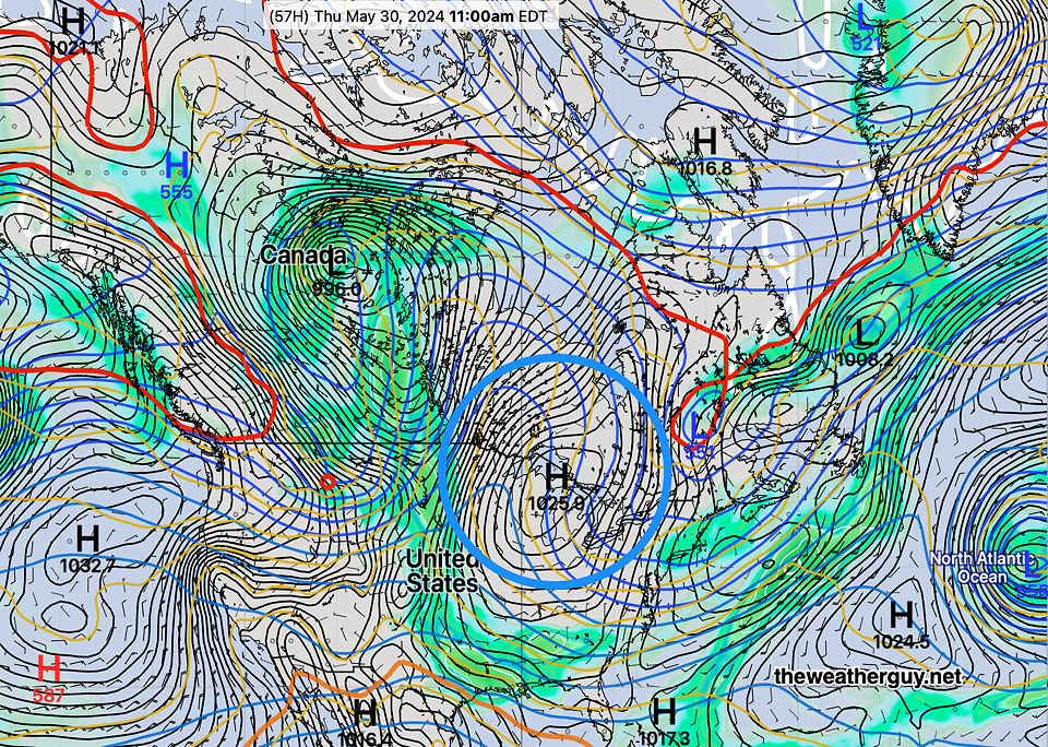
The weekend had been looking fine, but the latest NAEFS shows a warm front with showers moving in on Sunday—
Showers later Wednesday Afternoon
Posted Tuesday 05/28/24 @ 7:44 PM — A surface and upper trough approaches Wednesday with an increase in clouds after noontime with with showers and maybe some thunder during the afternoon.
Western suburbs may see some showers as early as 1-2 PM, but many models hold off the showers until 4-6 PM closer to the city. Some models are showing gusty winds preceding the showers late afternoon.
This afternoon’s GFS forecast for 2 PM Wednesday shows an upper and surface trough moving through. The GFS shows an earlier start to the showers just west of the city. (Click on image for a larger view.)
Total rainfall looks to be light. Showers continue into early Thursday morning with rapid clearing by about 10 AM. Becoming windy.
Cooler and windy for Thursday afternoon.
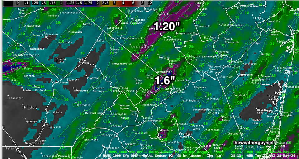
Previously Posted Tue 12:20 PM —Sunday’s rains were not all that heavy or severe. Here’s the MRMS-based rainfall summary —
MRMS combined rain gauge & radar-based measurement of rainfall received. Color shading is in inches. Line contour numbers are in mm (25.4 mm= 1 inch) Most areas received under 1 inch of rain. (Click on image for a larger view.)
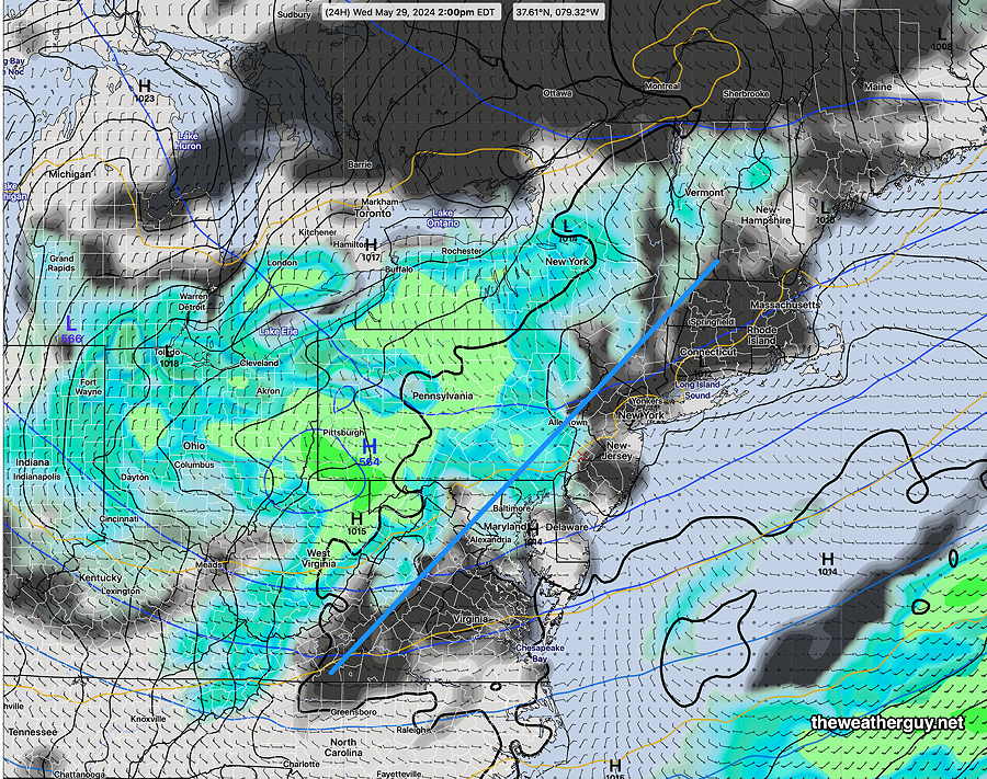
Following a system that may bring us some rain later Wednesday, a large, cool high pressure system will bring very nice weather possibly through the weekend—
NAEFS forecast for Thursday at 11 AM. Large high pressure will move down over our area providing cool, dry weather likely through the weekend. (Click on image for larger view.)
Next week should see a return to much warmer temperatures.
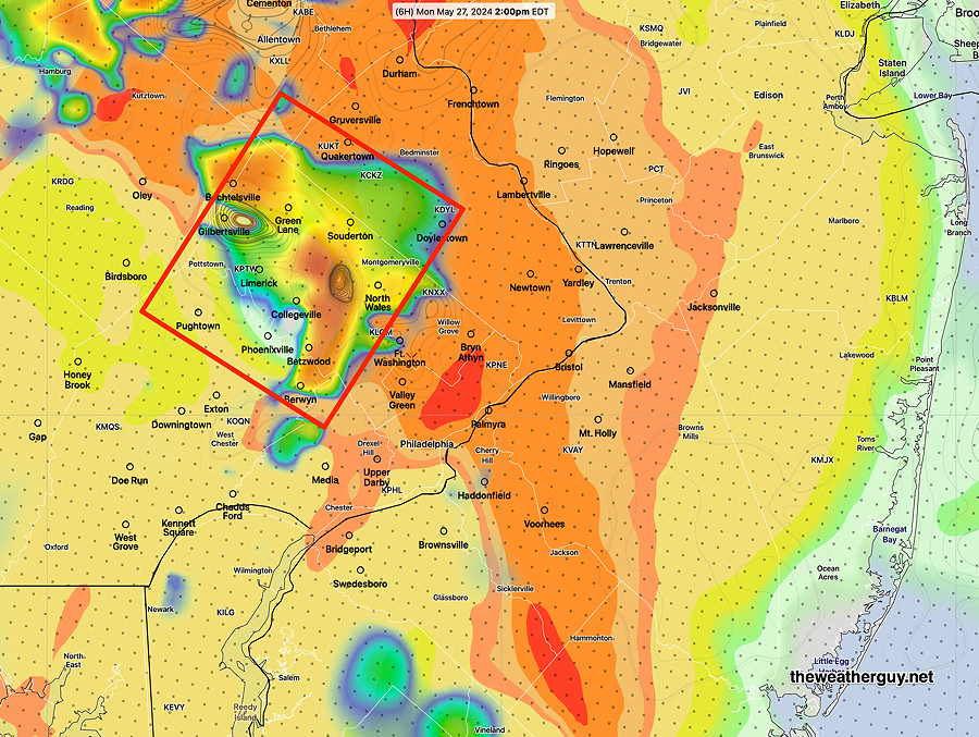
Update Mon 5/27 6:08 PM — The TV forecast I heard about an hour earlier was still emphasizing severe weather, tornados, hail this evening. I wish I saw evidence for this in the models. Some thunderstorms still possible with gusty winds.
Posted Monday 05/27/24 @ 10:39 AM — This morning’s HRRR (12z) shows some moderately elevated severity parameters (CAPE, Vertical Shear and Helicity) about 2 PM in upper Montgomery county.
Today’s 12z HRRR shows elevated moderately elevated severity parameters about 2 PM in upper Montgomery county. As is mostly the case, exact model placement of this area of potential severe weather is often never exact. (Click on image for a larger view.)
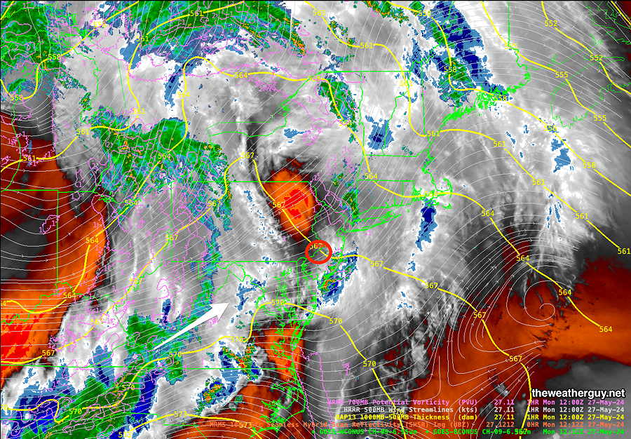
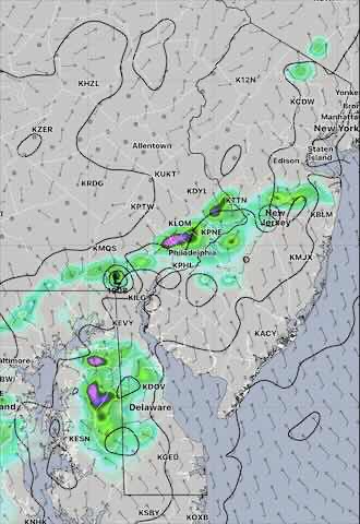
Posted Monday 05/27/24 @ 8:38 AM — Here’s the latest satellite water vapor image with superimposed MRMS radar—
Current satellite water vapor image with superimposed RAP model 500-1000 mb thickness lines (yellow), potential vorticity (fine violet contours) with superimposed MRMS RADAR. The area of clearing to our northwest will give us some bright skies and sun this morning. The impulse (white arrow) in West Virigina will bring more rain by about 2 PM. (Click on image for a larger view.)
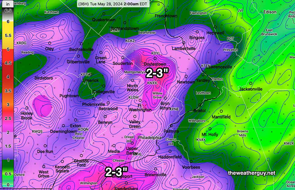
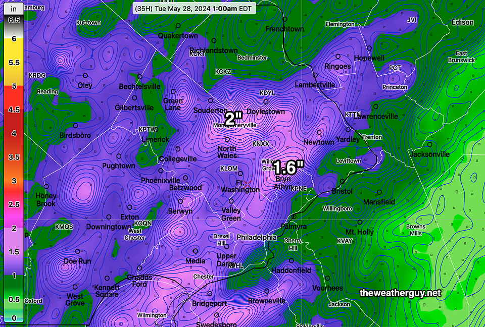
Update Mon 5/27 7:32 AM — Last night’s model capture the following trends — We may see a brief period of sun or bright skies late morning. It appears that the heaviest rain will fall in far northern areas, closer to Allentown.
The showery rain with embedded thunderstorms will begin in the early afternoon and continue on and off through about 10 to 11PM. Wind gusts and localized heavy rain expected especially this evening, but severe weather will be most likely far north into Lehigh county and to our south in Maryland. Rainfall totals will be closer to 1 inch in the immediate Delaware Valley, rather than the 2-3 inches posted last night.
I’ll update if this morning’s models show significant changes.
Rainy Monday on Tap
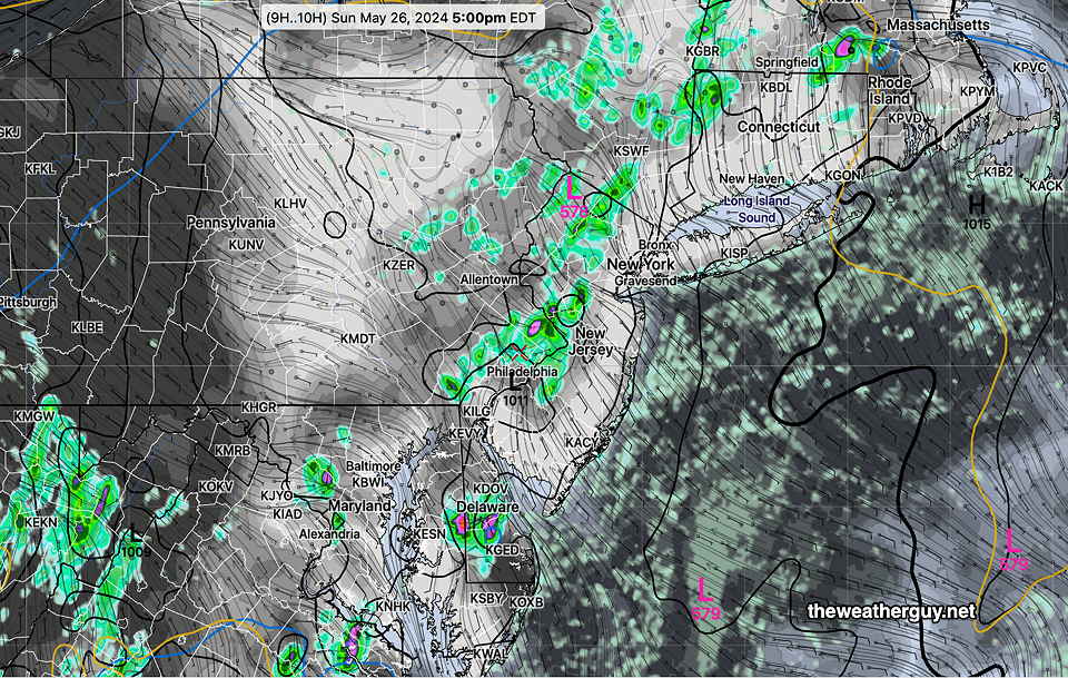
Posted Sun, 05/26/24 @ 5:37 PM— Several rounds of rain will move through during the day on Monday, beginning before daybreak and continuing through mid-evening. The rain will be showery in nature, not a continuous rainfall, and there will be embedded thunderstorms.
The heaviest rainfall will likely occur early Monday evening with some heavier, stronger thunderstorms. While severe weather doesn’t appear to be likely, it never can be ruled out
The NBM and HREF show anywhere from 1.5 to almost 3 inches of rain, mostly in the immediate Delaware Valley area—
This afternoon’s HREF forecast total rainfall for Monday. (Click on image for larger view.)This afternoon’s 18z NBM is somewhat more conservative with its total rainfall prediction. (Click on image for larger view.)
Increased Signal for Thunderstorms Sunday
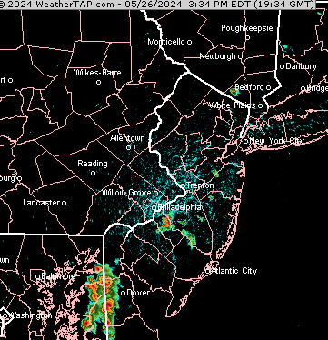
Posted Sun 5/26 4:04 PM — Storms developed, just east of the I-95 corridor, this afternoon. That’s about as good models can get with this sort of thing.
Despite many days of forecasting heavy rain for Monday, some models have backed off from this. Will update later.
Posted Sun, 05/26/24 @ 10:21 AM— The latest NAM-NEST continues with a forecast of pop-up storms Sunday, between 4 PM and 6 PM along the I-95 corridor.
Update Sun 5/26 7:32 AM — Yesterday’s forecast for thundershowers didn’t materialize, as storms to our west dissipated as they approached our area last night and pop-ups didn’t occur as forecast during the daytime.
Unlike yesterday, there’s greater model consensus that some pop up storms will develop in and around the I-95 corridor during this afternoon. A stalled frontal boundary along with high CAPE values (approaching 2000 j/kg2) should provide enough of a trigger.
Update Sat 5/25 8:32 PM — We may still see some showers move in this evening, especially western suburbs, but I have to say that the Canadian models over-forecast the scattered shower potential for today.
The weak boundary moving through this evening will stall and move north as a warm front early Sunday. As that happens, some new showers and thunderstorms may spring up early Sunday morning but coverage will be limited.
As the warm front moves north, a mostly sunny Sunday is expected, but there may be periods of clouds at times in some areas. Limited, widely scattered showers are possible again Sunday afternoon and more so Sunday evening. It will be more humid. Monday still looks rainy in the morning with heavier showers and thunderstorms in the evening.
Previously Posted Fri 3:24 PM —
This weekend’s weather will be dependent upon a a series of frontal passages that include a stalled cold front returning as a warm front on Sunday morning and then stalling again. Passing along that front will be a series of disturbances, that along with daytime heating instability, will trigger isolated or scattered thunderstorms. Plenty of sunshine will also add to the unstable mix.
Exact timing and placement of these frontal passages will be difficult to forecast. After reviewing numerous models, I’m leaning towards the Canadian RGEM and HRDPS which did exceptionally well with last season’s thunderstorm forecasts. Adding credence to their forecast is the GFS, the experimental RRFS, and the ICON EPS which seems to have a somewhat similar forecasts.
Not in support of this forecast is the latest HREF which downplays showers significantly in our area for Saturday and Sunday. The ECMWF is similar for Sunday’s forecast, but not so much for Saturday. So a difficult forecast to pin down.
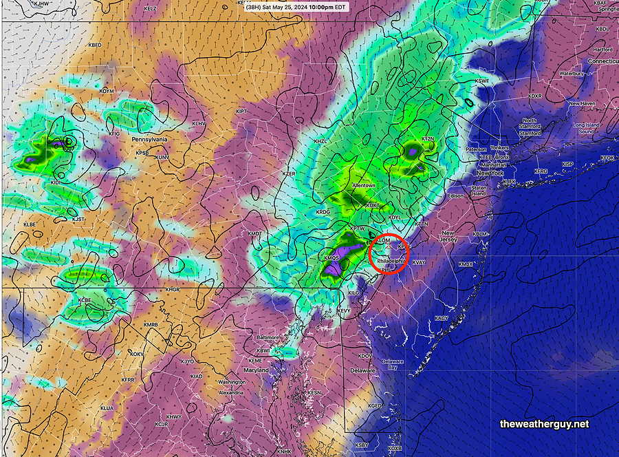
Saturday
Sunny in the morning, sunshine through thin high clouds in the afternoon. Increasing cloudiness late afternoon. A chance of widelyscattered thunderstorms especially west of Philadelphia after 2-4 PM and more organized showers and thunderstorms moving in from the west after 8 PM.
Canadian RGEM shows widely scattered showers/thunderstorms as early as 4 PM. (Click on image for a larger view.)Experimental RRFS shows showers/storms moving in from the west about 10 PM Saturday. The RRFS does have a tendency to over-predict thunderstorms. (Click on image for a larger view.)
NBM high temperatures: Blue Bell, PA 86º Philadelphia, PA 87º uncertainty (based on standard deviation): low
Sunday
Becoming mostly sunny after some morning residual showers/storms. The front that moved through Saturday night stalls and moves back as a warm front. Instability will result in pop-up showers/thunderstorms during the afternoon .
NBM high temperatures: Blue Bell, PA 85º Philadelphia, PA 86º uncertainty (based on standard deviation): low
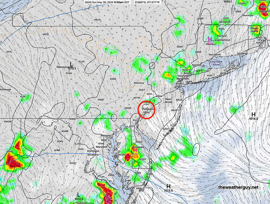
Monday
Showers and thunderstorms beginning daybreak or early morning and continuing off and on. There may be a taper in the afternoon. Heavier rain and storms beginning Monday evening.
NAEFS model statistical “mode” version with overlayed GEFS model “bias-corrected” precipitation forecast for Monday at 2 PM (Click on image for a larger view.)
NBM high temperatures: Blue Bell, PA 78º Philadelphia, PA 80º uncertainty (based on standard deviation): high uncertainty