
#Philadelphia #weather #PAwx
Friday and Weekend Outlook- Rain to Snow late Mon ->Tues
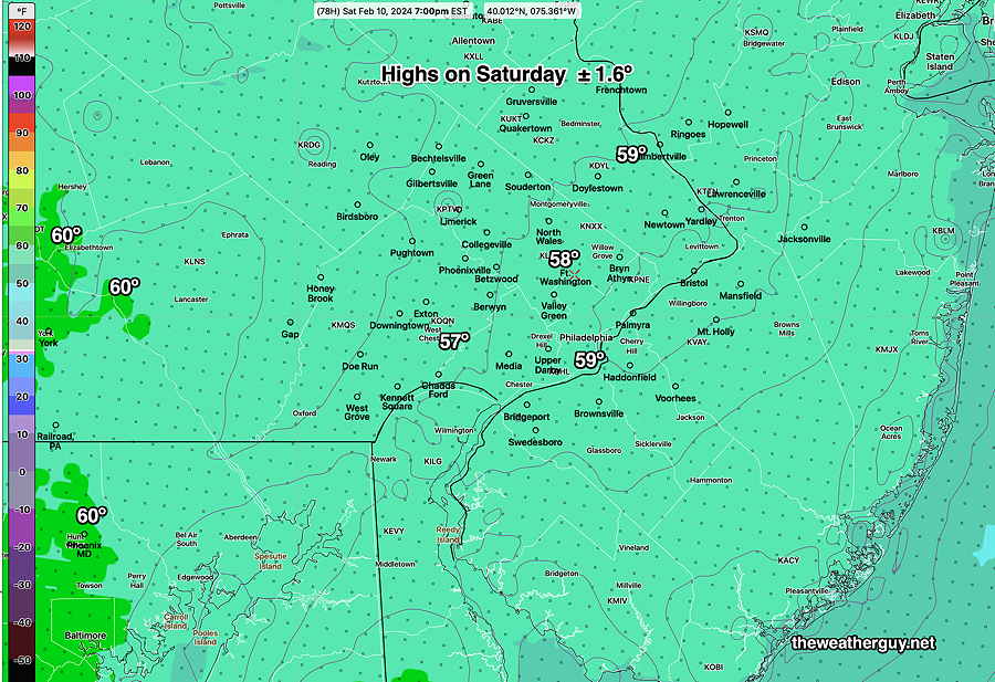
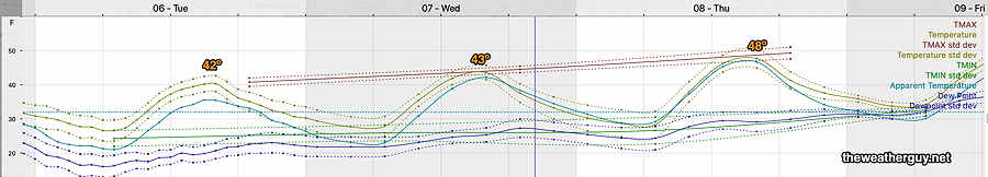
Posted Friday 02/09/24 @ 7:58 AM — We should see clouds break by mid morning today, Friday. Highs will get to 56º-57º
Cloudy on Saturday, with some bright spots possible in advance of a slow moving cold front. In the immediate area, little in the way of showers are forecast, although a few models crank out some scattered sprinkles, generally about 0.01″ but up to 0.04″ northern suburbs.
Highs about 57º, maybe 59º. (NBM standard deviation – uncertainty – is a bit greater than average at ± 2.1º)
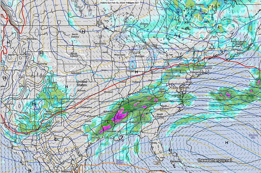
The cold front stalls to our south late Saturday night.
A forecast change for Sunday. Sunday , originally expected to be sunny, is now expected to be cloudy, as moisture and rain move along the stalled front to our south.
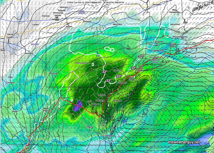
Increasing signal for rain late Monday night changing to wet snow around daybreak Tuesday. Warm temperatures at the surface (currently) and a slow influx of colder air aloft will keep any accumulations by Tuesday afternoon to be wet and in the 1 maybe 2″ on grassy surfaces from the city north and westward. Too much warm air for a real snowstorm and ground “skin” temperatures are well above freezing, making it difficult for any snow to accumulate.
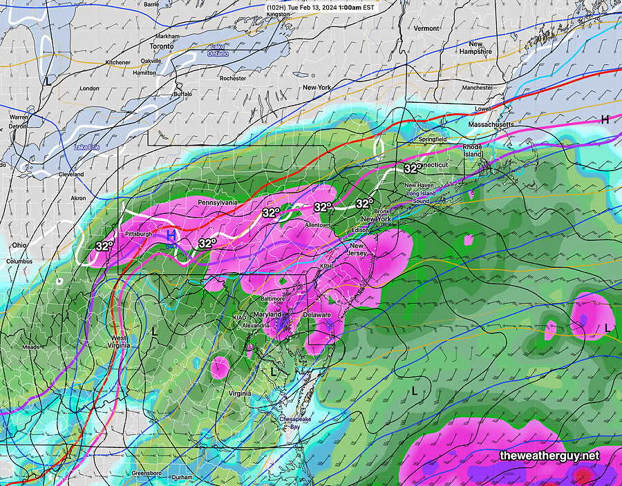
This storm has continued to evolve and show greater intensification over the past days. Stay tuned for updates.
Friday and Weekend Outlook & Pattern Change
Posted Thursday 02/08/24 @ 7:20 PM — A warm front uneventfully moves through tonight (perhaps with a few sprinkles) and milder temperatures are forecast for Friday with plenty of sunshine. Highs 55º-57º.
A slow moving cold front approaches on Saturday with plenty of clouds during much of the day (perhaps some sun mid to late afternoon). Highs 57º-59º. It’s look less likely that we’ll hit or exceed 60º
Colder temperatures for Sunday, but still above average.
The cold front that went through on Saturday stalls to our south, as low pressure develops along the front and moves east. Some rain here late Monday.
I’ve been following the potential for some snow on my Winter Storm page and it is looking increasingly likely for early Tuesday, but temperatures will be just above freezing, limiting accumulations.
The latest GFS, just available, is most aggressive with the potential snowfall and precip—
So we’ll have snow to the north and rain from the city south, according to this GFS model run. Even suburbs north of Philadelphia will be above freezing near the surface, diminishing potential accumulations. Too early to hang one’s hat on any specifics. Stay tuned.
Next week looks cold again.
Thursday Update
Update Wed 2/07@ 10:00 PM — An increase in forecast cloudiness and an increasing chance of light showers on Saturday makes me question the high temperatures in the 60s being forecast by the earlier NBM. I’ve put in the range 55-60° in the preceding post for that reason.
Posted Wednesday 02/07/24 @ 5:19 PM — An approaching warm front will bring some high cloudiness late morning on Thursday and some mid level clouds after 3 PM. Highs in the low 50s
Friday will be sunny and milder. High in the low 50s, perhaps 55.º
Saturday is looking quite cloudy with an increasing signal for some very light sprinkles, especially far western suburbs. High 55º-60º Increasingly windy towards evening with an approaching cold front.
Following a cold front, Sunday will gradually “chill” down to a high in the low 50s and temperatures will drop later in the day.
Monday into Tuesday looks interesting. (I’ve updated my Winter Storm page again today.)
Blocked Pattern Gradually Breaking Down
Posted Tuesday 02/06/24 @ 6:05 PM — The blocked weather pattern that has brought us the fair weather will gradually break down. The warmer air that’s been to our west and south will gradually move in as a warm front Thursday into Friday with an increase in clouds. We won’t get into the warm sector until Saturday.
Temperatures on Saturday will reach anywhere from 54º to 60º with 58º most likely. An approaching cold front is currently not predicted to bring any showers until Saturday night, if at all. The cold front will stall to our south, setting the stage for a bit more winter-like weather early next week. (I’ve updated my Winter Storm page today.)
For the weekend, the question exists how much cloudiness we’ll see and whether any showers move in here with the cold front. Currently, it’s looking fairly cloudy and mostly dry here, but that’s not a certainty.
The current ECMWF has showers staying out of our area on Saturday—
Tuesday through Thursday
Posted Monday 02/05/24 @ 6:08 PM — Continuing with the thread started earlier, temperatures are not expected to be all that warm through Thursday—
Sunny through Wednesday. A warm front moves through Thursday with an increase in cloudiness as the much anticipated warm front approaches our area. Cloudiness in some degree may linger for much of the weekend.
Continuing through the weekend, Saturday may be the warmest—

As mentioned, there’s uncertainty about how high the temperatures will actually be on Saturday. There may be clouds and it appears that it will be quite windy.
For the few who feel they are missing out on winter weather, things will get interesting by next Tuesday-Wednesday.
Previously Posted Mon 10:19 AM —We’re still in the blocked pattern (omega block Ω) with sunny skies and ongoing nice weather. Unfortunately, we remain in the somewhat colder side of the omega block pattern, despite the TV weather people’s ongoing focus on how warm it’s [possibly] going to get.
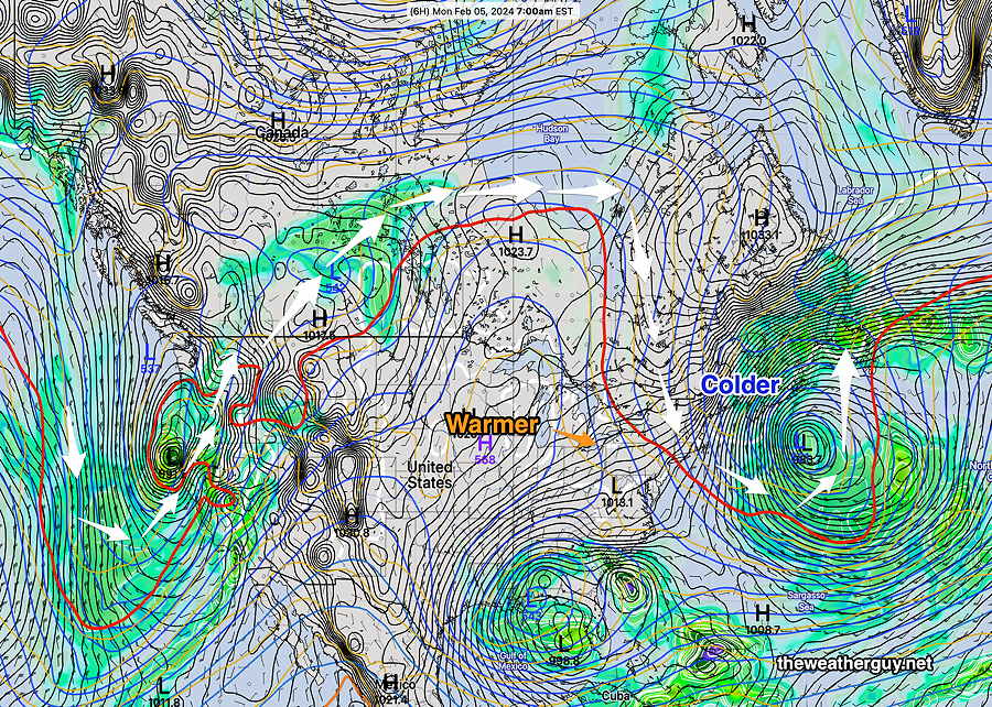
(Frankly, the weekend weather was beautiful, especially for February, but I would hardly describe it as warm.)
The colder flow over us continues, with a reinforcing bit of colder air on Tuesday. While we’ll have above seasonal averages, it won’t be ‘warm’ until the weekend. The latest NBM has some mid-50s temps for us on Friday and the real warmth arrives possibly on Saturday. I say possibly because some cloudiness will also arrive and the upper air pattern flattens at that time. It does look like it hits near 60º but it’s not a sure thing.