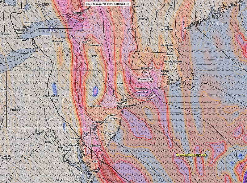
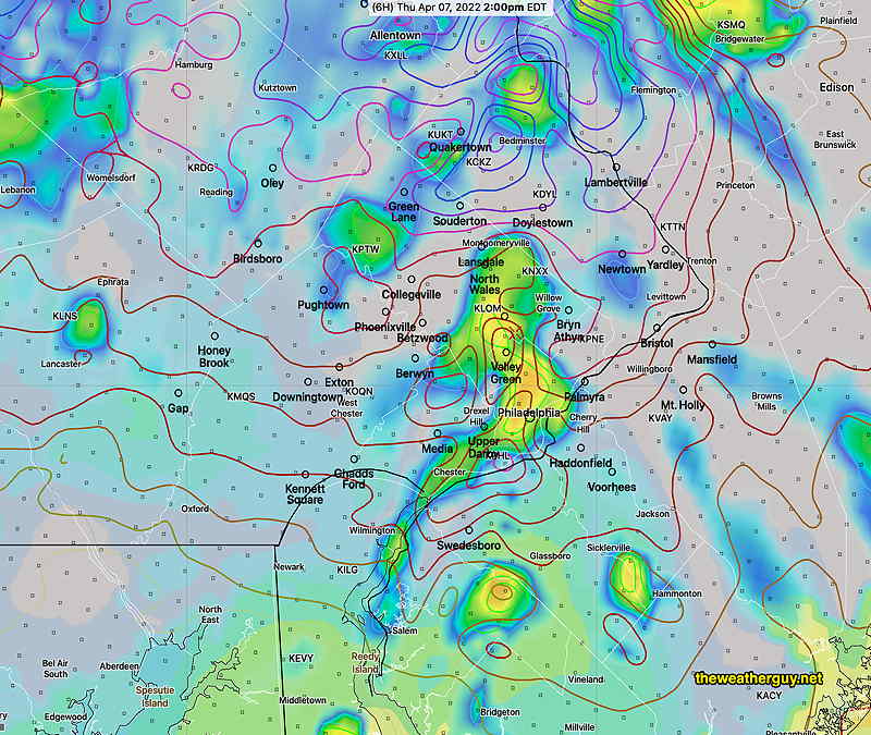
Update Sat @ 9:56 PM — For Sunday, today’s models show a significant amount of mid-level cloudiness developing towards noon Sunday and dissipating mid to late afternoon. There will still be plenty of breaks sunshine. It will be windy and chilly; the high temperature of 51° will be reached late in the day.
There’s even a chance of more sprinkles in the late afternoon, especially north and west of our area.
This cloudiness is the result of continued instability and a stream of upper air disturbances passing over us, rotating around the departing upper air low.
GFS 500 mb vorticity at 3 PM Sunday. The western back edge rotates through our area about 4-5 PM, allowing clearing (Click on image for a larger view.)
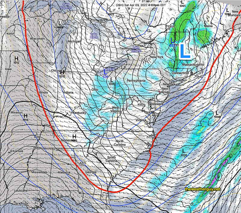
A deep upper trough over our area will bring unsettled conditions on Saturday and cooler than seasonal average temperatures. The trough gradually moves away on Sunday, but still affects us. A upper ridge with milder temperatures moves in next week.
Saturday
The upper trough will result in considerable instability cloudiness and showers. Showers will be widely scattered, more numerous early morning, then breaking out, scattered again, in the afternoon. There may be significant sun late morning before instability clouds develop.
Today’s 18zNAM forecast for 4 PM Saturday. A low pressure system over Vermont and an upper low over Lake Erie with a deep trough, indicated by the red 540 thickness line. Showers and clouds over our area. (Click on image for a larger view.)
A mix of clouds with breaks of sun, not very different than last Saturday. We’ll have widely scattered showers, especially in the afternoon. The cold air aloft may again result in some frozen form precipitation (graupel), much like last weekend. WINDY at times. High temperature 53.3º ± 2.1º NBM model, Blue Bell. (Average seasonal highs are 60-61º)
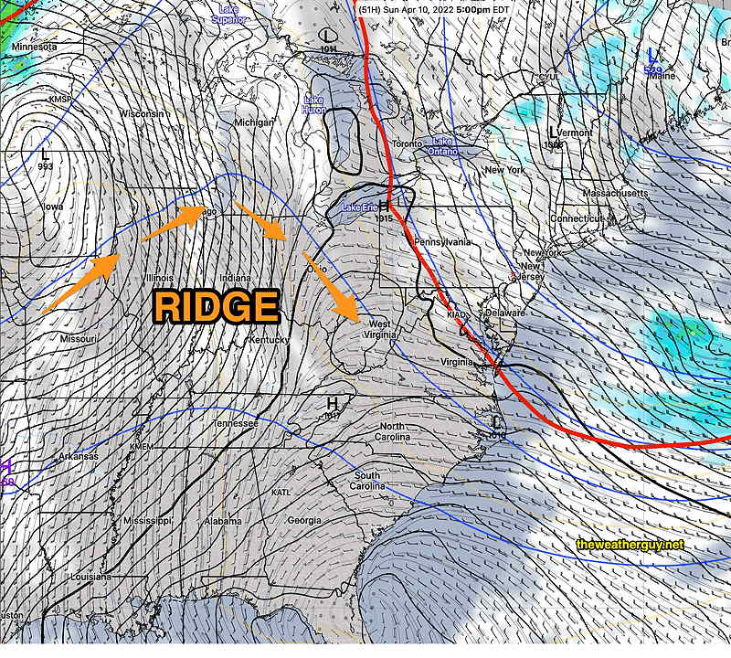
Sunday
The trough begins to lift, but the cold air will still be over our area.
Today’s 18z NAM forecast for Sunday at 5 PM. Surface low still over New England, upper trough (red line) moving up and away. Some clouds but dry weather here. Upper ridge poised to move in from the west for next week. (Click on image for a larger view.)
Mostly sunny skies with still cool temperatures. Gusty winds at times. High temp 50.3º ± 2.0º NBM model, Blue Bell.
A ridge moves in next week with warmer temperatures.
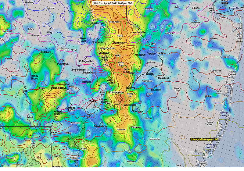
Thu 7:15 PM Forecast Review — Just a lot of rain today. The missing ingredient was CAPE. But this evening, we’re getting to see what minimal CAPE and high helicity/shear can do with thunderstorms developing. The timing of the impulses moving through has changed, with the NAM-NEST now showing areas of heavy rain through until midnight.
Update Thu @ 10:20 AM — Differences in timing between HRRR and the NAM-NEST…the latest NAM-NEST has storms lasting through 9 PM.
Update Thu @ 9:48 AM — The latest HRRR just became available.
Without any CAPE, we’re already seeing thunderstorms move through, due to enhanced helicity, vertical shear and vertical motion.
Additional rounds of thunderstorms expected. Some of the heaviest are expected between 2PM and 6 PM, with additional activity until about 11PM. Note that the latest HRRR has joined the NAM-NEST with increased CAPE in the afternoon, suggesting stronger storms in the afternoon.
Todays 12z HRRR showing simulated radar: scattered storms with enhanced helicity (contours) and CAPE at 2 PM. These continue through 9 PM, heaviest activity 2-6 PM. (Click on image for a larger view.)
Update Wed @ 10:30 PM — The NAM-NEST has been consistently showing more intense weather for Thursday. Here’s the latest forecast, showing a line of heavy storms moving through 4-5 PM in the immediate PHL area—
Tonight’s 00z NAM-NEST showing simulated radar forecast: strong storms with superimposed helicity contours at 5 PM Thursday. (Click on image for a larger view.)
Update Wed @ 9:43 PM — Today’s ECMWF has over 3 inches of rain falling in parts of South Jersey Thursday.
Update Wed @ 8:45 PM — Low pressure will move almost directly over us on Thursday. Periods of rain, heavy at times, will begin in the morning and continue into the evening. Some thunderstorms will be embedded with these showers and are most likely late afternoon until about 9 PM in our area. There may be somewhat of a reduction in the action from noon until mid to late afternoon.
Severe weather is being understandably down-played by the NWS due to the lack of sunshine expected during the day and a forecast of almost zero CAPE at the surface.
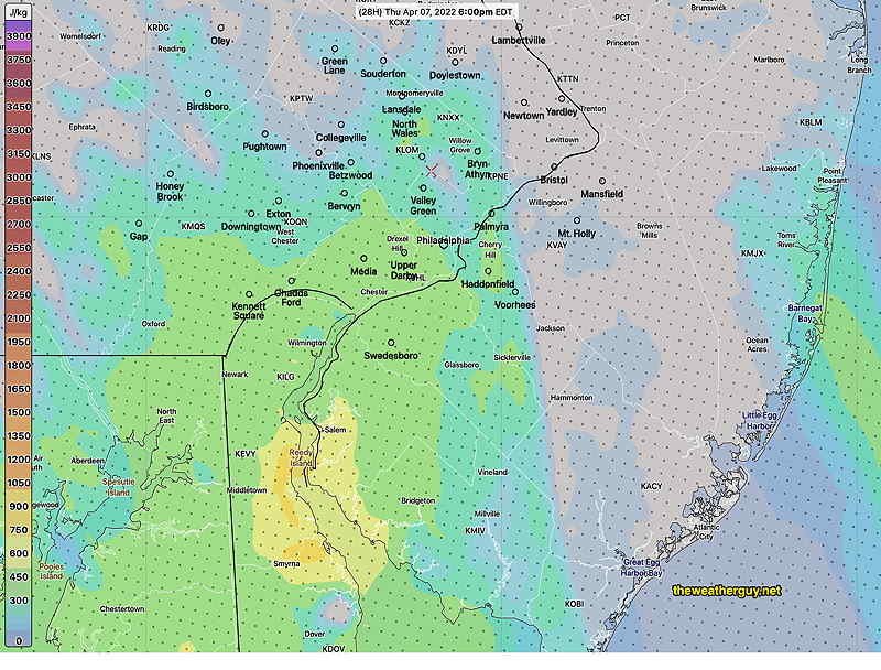
Nonetheless, some CAPE is available at higher levels
HRRR forecast mixed layer CAPE Thursday at 6 PM. Even CAPE at this level is relatively low. (Click on image for a larger view.)
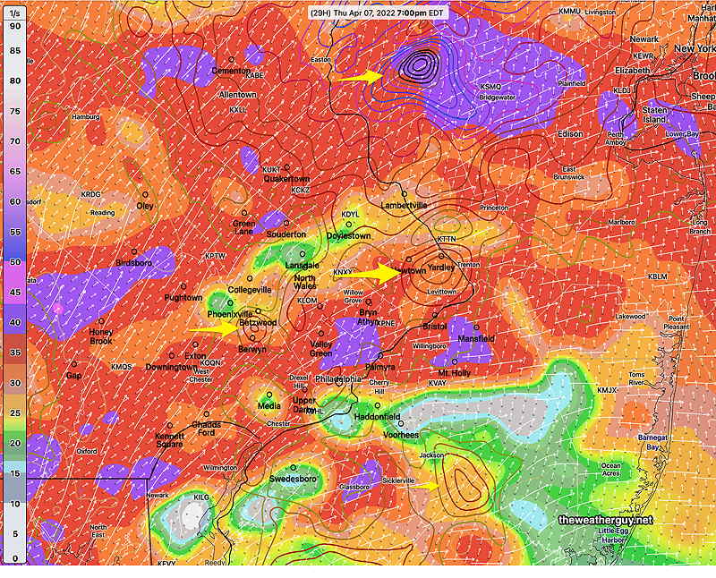
Helicity and vertical shear are expected to reach high levels between 4 PM and 9 PM, especially areas north towards Allentown. This could translate into thunderstorms with strong wind gusts at times and heavy downpours.
Of interest, the shear levels are at or above 40. However the shear does not line up with the storm motion vectors, making the shear impact less potent. Nonetheless, there are areas forecast for superimposed high shear and high helicity—
Today’s 18z HRRR forecast for 7 PM Thursday, showing areas of high shear (shading) (>35) and high helicity (>500) (concentric contours) White streamlines are shear direction. White short arrows are storm motion vectors. They are not very well aligned. Yellow arrows point to areas of overlapped high shear/high helicity. Remember, this a modeled forecast snapshot in time. (Click on image for a larger view.)
Heavy rain (1.3-2+ inches) in some areas is expected before things clear out about 11 PM.
Should the cloud cover be less than forecast and some sunshine peaks through (not expected), things will change.
Update Wed @ 8:35 AM — Last night, I toned down my forecast for the possibility of strong/severe storms on Thursday afternoon.
However, last night’s 06z model runs of the NAM-NEST and HRRR still show high levels of CAPE and helicity, along with elevated vertical wind shear. So the possibility of severe storms still holds for Thursday afternoon into early Thursday evening.
Update Tue @ 11:13 PM — Tonight’s HIRESW models are looking much more benign regarding severe storm potential. Only the NAM continues the possibility. Severe storms now seem much less likely.
Update Tue @ 8:12 PM — For Thursday, low pressure and an approaching strong cold front will cause conditions to become conducive for the development of strong to severe thunderstorms during the afternoon hours. High levels of CAPE and helicity, along with elevated vertical wind shear, may combine to create severe weather conditions.
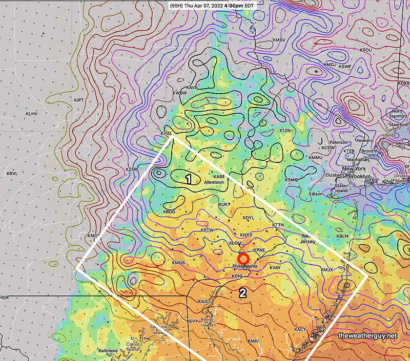
Todays 18z NAM-NEST forecast for 4 PM Thursday. Highly elevated helicity (contours) especially around Allentown (1), Jersey Shore and elevated CAPE (orange shading) extending from south to north into Philadelphia (2). Strong to severe thunderstorms possible. (Click on image for a larger view.)
Update Tue @ 9:27 AM — Last night’s models continue with the forecast that today will be cloudy with most of the rain holding off until later in the afternoon or early evening Tuesday
The forecast for Wednesday continues to be rain ending in the morning, but dark low clouds with a northeasterly wind may allow some drizzle or widely scattered sprinkles through much of the early to mid afternoon.
Thursday looks to be rainy with a strong cold front moving through. I’ll be keeping an eye on any ‘interesting weather’ for Thursday.
A deep trough develops and moves in for Friday. Possible repeat of scattered showers with ice (graupel) mixed in. Unseasonably cold.
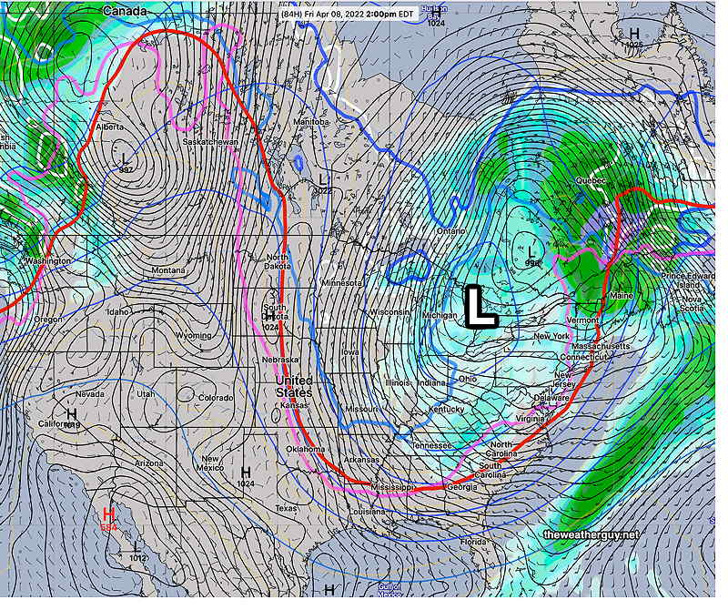
06z GEFS forecast for Friday- Deep upper low in the Great Lakes area and strong dip in the jet forming an upper trough. Instability showers, possible ice pellets (graupel). The cold weather will be with us through Saturday, but moderates considerably by Sunday. (Click on image for a larger view.)
Update Mon @ 5:07 PM — Depending upon your model preference, it appears that Tuesday will be cloudy with most of the rain holding off until later in the day. There may be a few very light, widely scattered showers in the afternoon.
Wednesday will be rainy early, but it tapers off and ends late morning and much of our area from Philadelphia and westward should have very little additional rain.
Rain develops again Wednesday evening.
Thursday looks to be rainy.
Previously Posted Sun 8:24 PM —
This week’s weather forecast is already appearing difficult to nail down accurately.
A strong low pressure system will take up shop in the Great Lakes area while several warm fronts will attempt to move north of us Tuesday, Wednesday and Thursday.
Timing differences could result in several rainy days or it could time in such a way as to have rain occur late afternoon Tuesday and early morning Wednesday with the rain at night and with much of the daytime hours milder and rain free.
The current NAM is an outlier for Wednesday with 70º temperatures and a warm front north of us. (No other model is forecasting this.)
Secondary lows along the coast and Appalachians will develop and move up towards us late Tuesday through Thursday. A weather map is worth a thousand words—
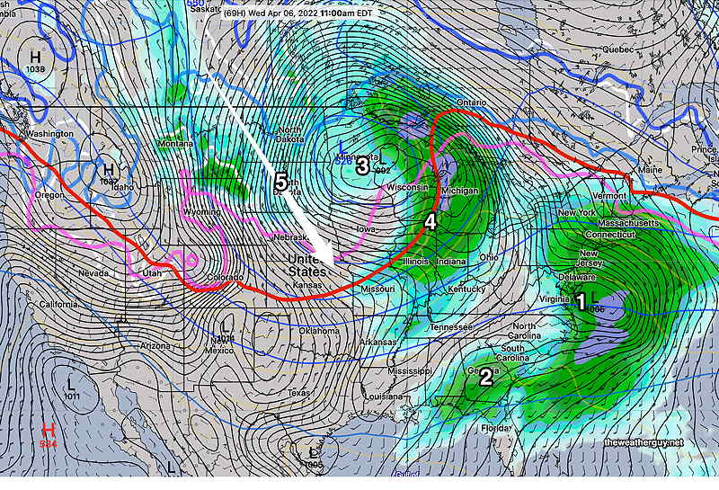
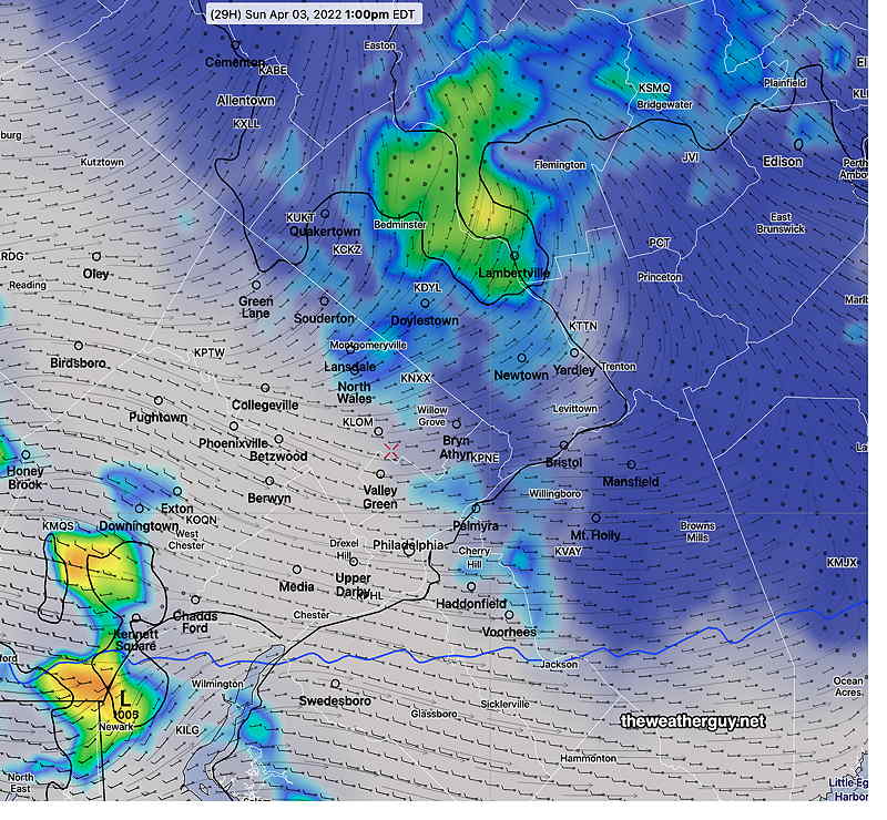
GEFS mode forecast for Wednesday at 11 AM. A large low west of the Great Lakes (3). Secondary low (1) may move in late Tuesday and move away fast enough that Tuesday and especially Wednesday are a nice days. Another low forming (2) will move in for Thursday with rain. Cold front (4) moves in for late Thursday into Friday and cold air (5) moves in for late Friday into Saturday. There’s much uncertainty with the speed of these systems and the resultant timing. Slight speed and timing changes will make large differences in the daytime weather. (Click on image for a larger view.)
Sun 2:33 PM Forecast Review — Some sunshine with increased instability from upper air disturbances gave us the showers. Some moved through an hour earlier than forecast by the HRRR. Cold air aloft resulted in some of the precipitation coming down as a frozen form called “graupel“.
NEXRAD radar at 2:15 PM with 500 mb wind streamlines (red). The radar image above looks remarkably similar to the NBM simulated radar forecast graphic just below (Click on image for a larger view.)
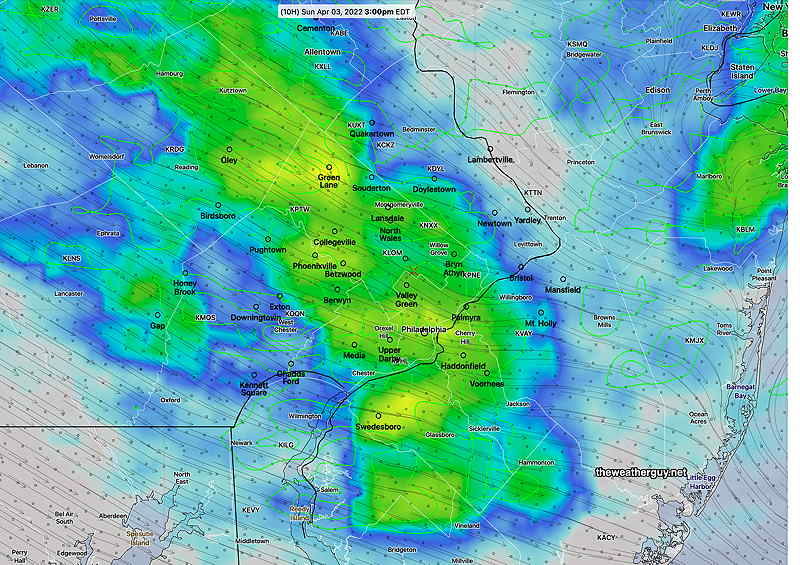
Update Sun @ 8:49 AM — Last night’s models are on-board with some sun and clearing about noontime followed by the development of an area of showers that moves through between 2-4 PM along with an increase in WIND. The showers will be from an upper/mid-level area of vorticity swinging through.
09z NBM simulated radar forecast for 3 PM Sunday (Click on image for a larger view.)
Update Sat @ 9:57 PM — This afternoon’s and tonight’s early models continue to show clouds and showers in the morning Sunday, but with breaks of sunshine moving in between 11 AM and 1 PM.
Despite intervals of sunshine, periods of clouds and widely scattered showers are predicted during the afternoon, the result of instability and several upper/mid-level air disturbances, especially in the 2-5 PM time frame.
The latest HRRR shows an area of significant showers around 3 PM or so. The air aloft will be very cold and some of those showers may fall frozen as graupel. Areas south of the city will have the most sunshine. It will become WINDY in the afternoon.
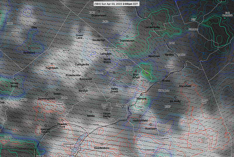
Tonight’s 00z NBM cloud forecast (shades of grey) and simulated radar (multi-colored concentric contours) at 2PM Sunday. Notice the areas of little to no clouds interspersed between scattered showers. (Click on image for a larger view.)
Update Sat @ 10:14 AM — Reviewing this morning’s early models along with last night’s models, it appears that Sunday will have showers in the morning, with additional showers AND some sunny breaks in the afternoon. The showers in the morning due to low pressure; the showers in the afternoon due to high instability and ‘self-destructive sunshine’, with a secondary low developing off the coastline. Windy.
Despite the occasional sunny breaks, the amount of showers forecast may put a damper on outdoor activities.
Today’s 12z NAM-NEST Simulated Radar and cloud forecast for 1 PM Saturday. Just a snapshot of a very changeable situation. But most of the area has clear skies despite the showers occurring in some areas. (Click on image for a larger view.)
Update Fri @ 9:44 PM — Just reviewed the ECMWF and tonight’s latest NBM. There’s more uncertainty regarding Sunday’s forecast, specifically how long the showers linger into the afternoon and how much clearing and sunny breaks we’ll see. The Sunday forecast posted below is currently on the optimistic side of things. I’ll update tomorrow.
High pressure builds in for Saturday. A low pressure system over the Great Lakes pulls an upper trough through on Sunday.
GFS model forecast for 8 AM Sunday morning. Showers and clouds will break for a mix of clouds and sunshine. The upper trough (as outlined in the red 540 thickness line) will cause instability clouds and widely scattered showers in the afternoon. (Click on image for a larger view.)
Saturday
A sunny but cool as high pressure moves in. Average seasonal high temperatures are 59-60º, but our high will be 54.6º sd 1.4º NBM model Blue Bell.
Previously Posted Fri 5:26 PM —
Sunday
An upper trough moves through with a weak cold front. Clouds and showers in the morning will break for a mix of clouds and sun in the afternoon. Instability widely scattered showers possible in the afternoon. WINDY in the afternoon. High temperature 54.6º (again!) sd 1.6º NBM model Blue Bell.
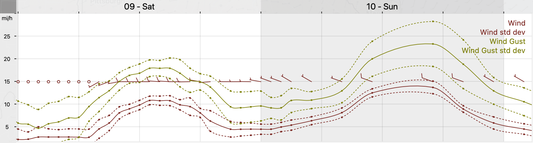
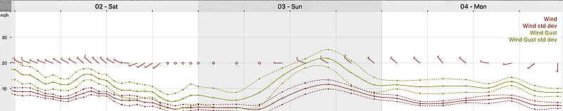
Winds
NBM wind forecast for Blue Bell, PA (Click on image for a larger view.)