Update Fri @ 9:52 AM — No significant change in the snow forecast. I’m going to borrow from my previous posts which basically captures the forecast:
From yesterday: “The models have all moved to a weak, unphased system with development occurring further from us. Totals of a coating to an inch are now forecast. “
From Tuesday: “A cold front moves through Saturday night and stalls. Low pressure develops in the southeast coastal area. Track appears offshore, but several models have some moisture over-running the stalled frontal boundary with some snow possible here on Sunday.”
So a coating to an inch is the forecast. The uncertainty is where.
Some models have the maximum precip from the city westward.Some have the maximum precip from the city eastward!
Temperature profiles run from a bit too warm to accumulate to cold enough to accumulate somewhat. Regardless of specifics the models are in agreement that much of it will be a rain or wet snow at the start, further reducing potential accumulations, then changing to snow.
The NAM has the highest accumulations (1.25″) and has the snow lasting into the afternoon. The GFS has the least, in some areas zero. The Canadian RGEM is forecasting about 1.2″ of snow.
Timing: The models have the snow/rain mix starting at 2-3 AM Sunday morning and ending either mid morning (ECMWF) or early afternoon (NAM).
I’ll update with my regular Weekend Weather Forecast later this afternoon/early evening.
Update Thu @ 7:46 AM — Last night’s models have uniformly moved to a weak, unphased system with development occurring further from us. Totals of a coating to an inch are now forecast. With the strong model agreement last night, I think we can lower the focus on this ‘storm’. Unless there are dramatic changes (not expected), my next update will be my regular Weekend Weather Forecast, usually posted late Friday afternoon or evening.
BTW, I should mention that the storm now falls into the range of the NAM, which shows 1-2 inches of snow. While I’m a big fan of the NAM for snowfall, its forecasts for such things are often not credible until about 36 hours ahead of the event.
Update Wed @ 8:28 PM — Another brief update. This afternoon’s ECMWF just became available as well as the ICON model. Both have moved towards a westward track and more snow for us. The ICON has 3″. Forecast is similar to this morning’s GFS which has subsequently moved in the other direction.
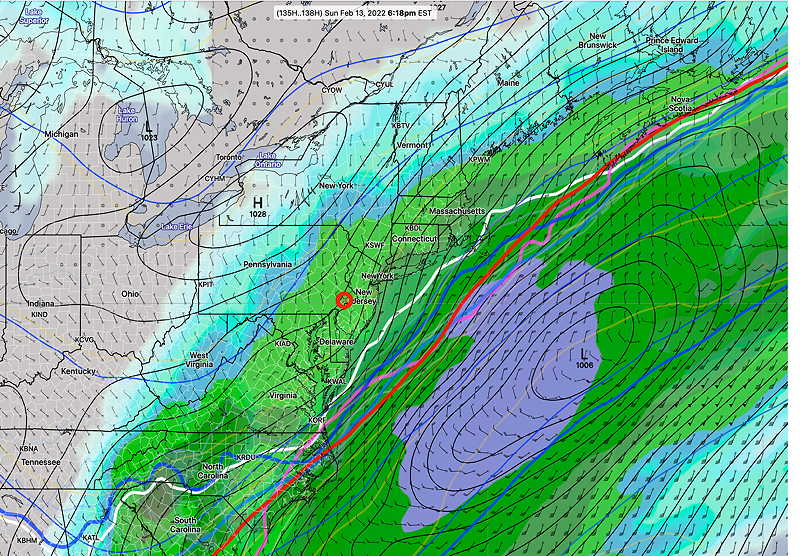
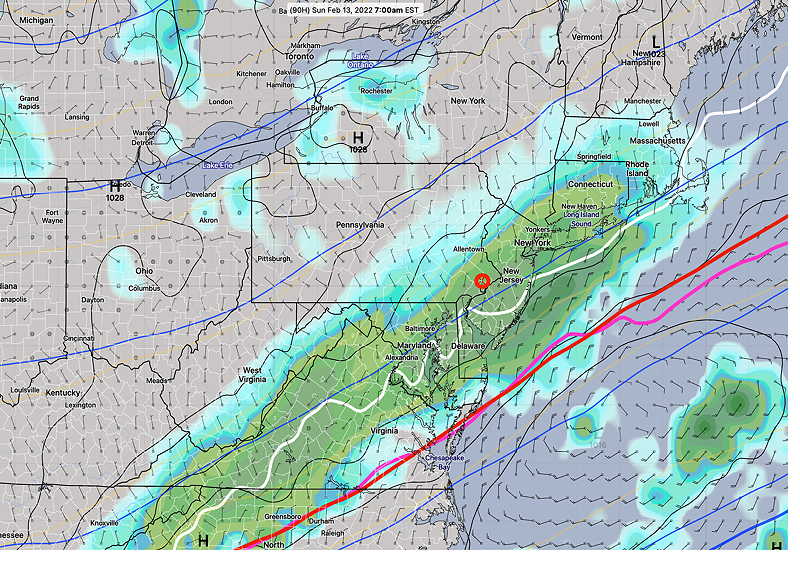
Here is the latest ECMWF 18z. (data available only until Sunday 7AM time frame)
Today’s 18z ECMWF forecast for 7 AM Sunday. Any precip (green-blue) north of the white freezing contour is snow. (Click on image for a larger view.)
We’re still in the 90+ hours time frame, requiring the global models. New updates tomorrow morning. The potential snow will then be in the forecast range of the RGEM, NAM and SREF models.
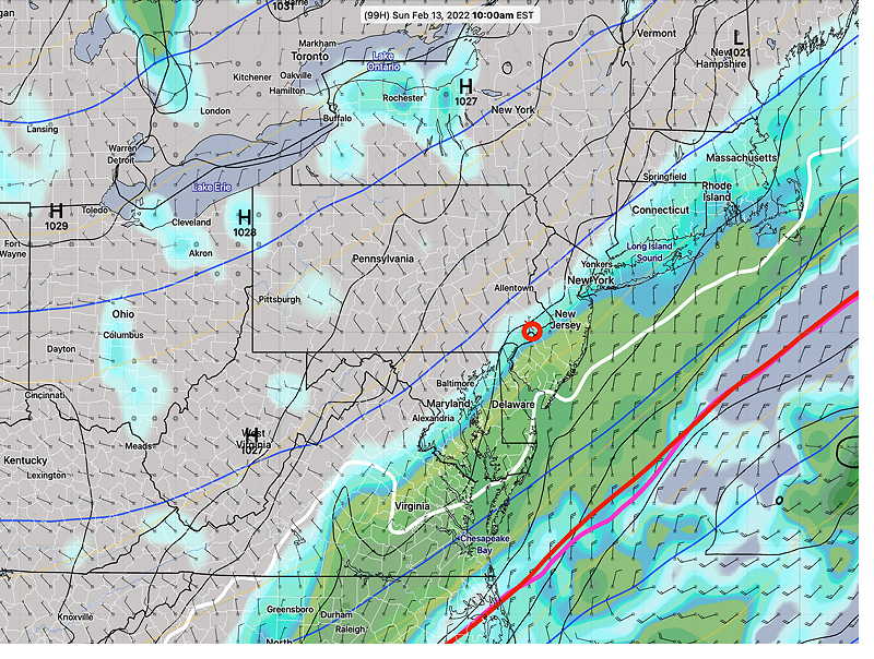
Update Wed @ 6:11 PM — Significant lack of agreement with the model forecasts for Sunday. The GFS and ECMWF have the jet stream phasing late, with the storm to our east. Minimal accumulation (1″ or so).
Today’s ECMWF 12z model forecast for Sunday 10 AM (Click on image for a larger view.)
The German ICON and the Canadian GEPS and GDPS have some phasing, enough to keep the storm near the coast, or in the case of the Canadian, inland!
In all cases, the amount of precipitation currently forecast would lead to 1, maybe 2 inches of snow. The Canadian’s western track would have a mix with rain.
Either way, no model is forecasting a major storm at this time. Things are likely to change. Stay tuned.
Previously Posted Wed 10:02 AM —
Over the past three days, a seemly benign weather pattern with a warm up on Saturday now shows signs of what I like to call “interesting weather” for Sunday.
A broad upper air trough was long expected to form low pressure system in the southeast coast: this had been expected to just brush us.
The GEFS has been suggesting for two days that more precipitation might develop. Here’s the scenario: A cold front moves through Saturday night and stalls. Low pressure develops in the southeast coastal area. Some moisture over-running the stalled frontal boundary results in some snow possible here on Sunday. Track of the coastal storm depends upon degree of upper air phasing.
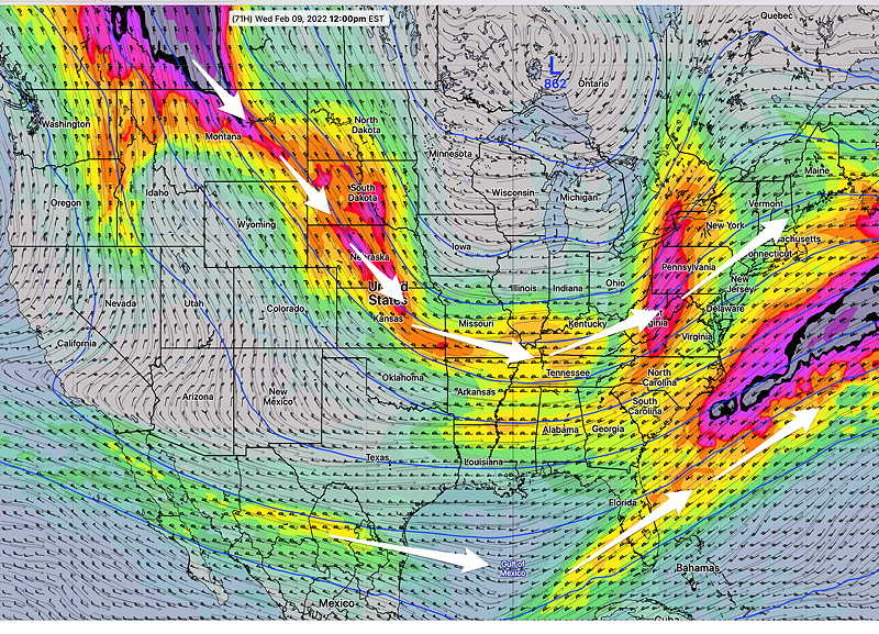
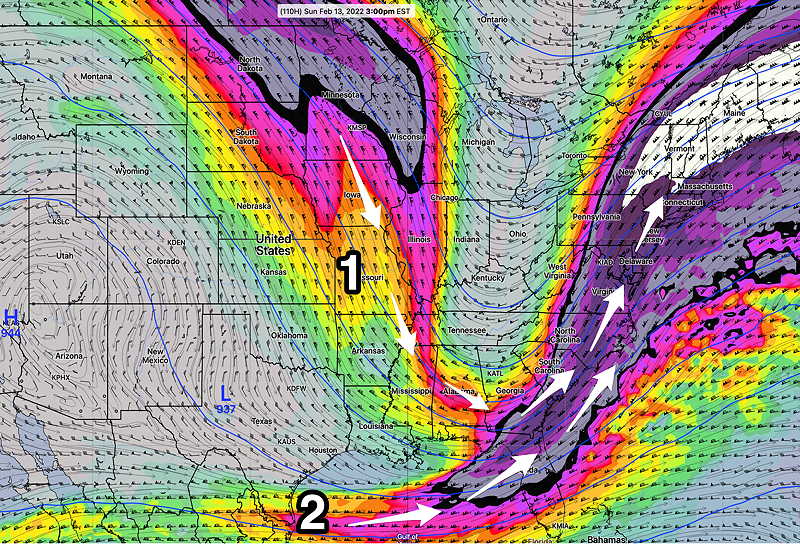
The latest GFS (06z) shows a northern-southern jet phased upper system with significant upper air energy—
Today’s 06z GFS shows increasingly phased system between the northern stream jet (1) and the southern stream jet (2). The colors represent wind flow within what’s called ‘jet streaks’. White represents winds approaching 200 mph! Phasing causes the upper flow to become more ‘amplified’ resulting in storms moving more northward vs northeastward. (Click on image for a larger view.)
The GFS is close to its ensemble version, the GEFS (suggesting increased confidence), but other models are not all on board with a phased upper flow.
Here’s a comparison of the GFS with the last night’s ECMWF (European). The ECMWF is not phased
Previously Posted Wed 10:02 AM —
GFS forecast with increasingly phased system Sunday
ECMWF forecast with less phased system
The difference for us between a phased system and unphased is a snowfall of >4 inches….. vs 1″, maybe 2″(unphased).
The German ICON and Canadian GEPS were somewhat closer to the unphased ECMWF. So this is “still up in the air”
Stay tuned. I’ll have a better sense of the trend late this afternoon after the other global models and ensembles have become available.
Update Wed @ 8:20 AM — A preliminary update. A quick review of last night’s models, particularly the GFS and GEFS, show a more significant snowfall possible for Sunday. (> 2 inches) Update later.
Update Tue @ 10:35 PM — Tonight’s major models, whose forecasts extend into the Sunday timeframe, don’t become available until midnight and afterwards. The afternoon GEFS became available earlier this evening continues with light snow (1-2 inches) on Sunday. I’ll update tomorrow morning.
Update Tue @ 5:48 PM — This afternoon’s models are leaning towards a more off-shore coastal storm with a reduced chance of snow here. Still something that still needs to be watched as there’s high forecast uncertainty in northwest quadrant of the storm.
The latest GFS model, just available—
This afternoon’s 18z GFS, just available, shows a complex system with some light snow for us, more from a secondary wave that develops on the stalled front. Several models show this area of snow in West Virginia, unrelated to the main coastal low. This is the forecast for Sunday at 1 PM. (Click on image for a larger view.)
On a different note, Saturday temperatures are forecast to be 57º ± 3º!
Update Tue @ 12:39 PM —A quick update. Mild weather expected through Saturday. A cold front moves through Saturday night and stalls. Low pressure develops in the southeast coastal area. Track appears offshore, but several models have some moisture over-running the stalled frontal boundary with some snow possible here on Sunday.
GEFS mode forecast for Sunday 6PM. ICON-EPS and Canadian model have about 1-2 inches of snow here on Sunday. Too soon to hang one’s hat on any forecast. (Click on image for a larger view.)
Stay tuned.
Update Mon @ 10:22 PM —We had the light freezing rain as predicted and the NAM-NEST along with the other models did pretty well with this forecast.
I had mentioned at the end of the previous post that a warm-up around Saturday was expected. It looks like it’s coming sooner, as soon as Wednesday.
NBM00z temperature forecast Blue Bell PA Wednesday thru Friday (click on image for larger view)
The NBM model is predicting high temperatures to be 51º Wednesday, Thursday and Friday for Philadelphia (with Blue Bell predicted high temps about 3º lower). Average season high temperatures are around 44º. So this may finally be our January Thaw.
A question mark for Thursday, as the ECMWF shows some shower activity while the GFS keeps us dry.
Previously Posted Sun 7:56 PM —
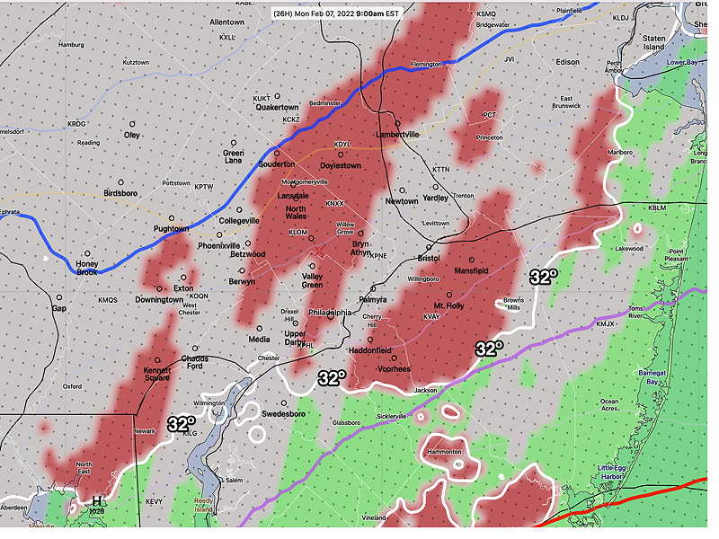
The week will start with coastal low pressure that is expected to move to our east Monday night. However, a weak flow ahead of the main center will result in very light freezing rain tomorrow morning, before daybreak. Total precipitation falling as freezing rain will be as little as 0.04-0.09 inches before changing to plain light spotty rain in the Philadelphia area after 9 AM or so.
This afternoon’s NAM-NEST is the most aggressive with the freezing rain amounts—
Todays 18z NAM-NEST forecast for Monday 9 AM (Click on image for a larger view.)
The rest of the week will continue a generally cold pattern as a broad upper air trough remains over our area—
Today’s 18z GFS jet stream winds forecast for Wednesday noon. Broad cold trough. (Click on image for a larger view.)
A possible warmup around next Saturday before another cold front moves through.
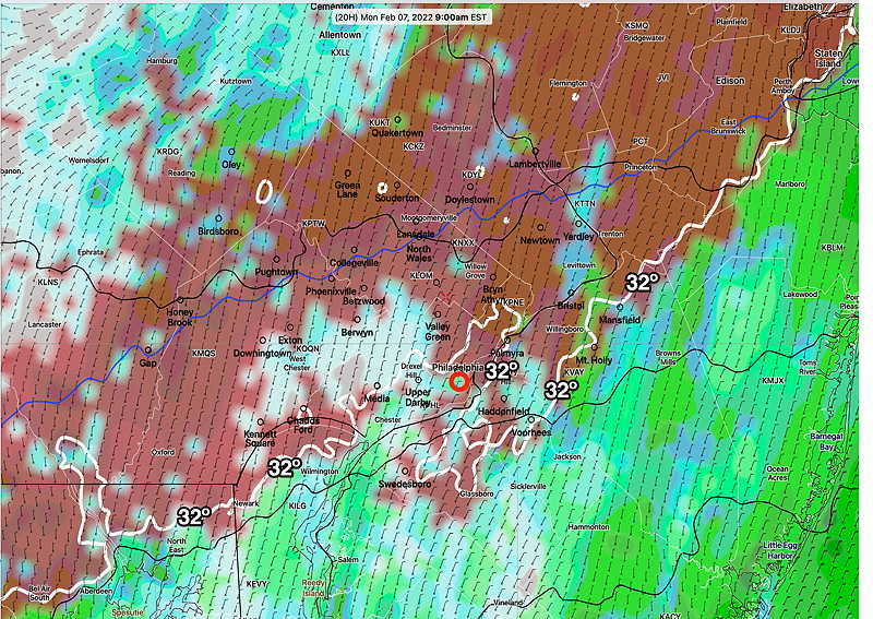
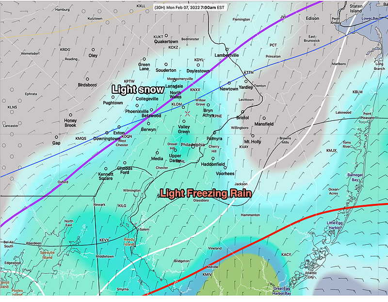
Update Sun @ 9:12 AM — Regarding the coastal storm passing to our east Monday evening, this morning’s HRRR, NAM-NEST and HIRESW have some light freezing rain moving in Monday morning during the rush hour, well in advance of the main low pressure center.
This morning’s 12z HRRR forecast for Monday at 9 AM. Freezing rain in red. (Click on image for a larger view.)Today’s 06z ECMWF forecast for Monday 7 AM, showing light freezing rain north of the 32º (white) contour and and light snow north of the (purple) 1000-850 mb thickness line. The ECMWF suggest that this starts before daybreak. (Click on image for a larger view.)
The main low is still expected to pass to our east with the edge of the precipitation shield being rain in our area later Monday afternoon and evening.
Update Sat @ 10:48 PM — Tonight’s models continue to show Monday evening’s coastal storm barely brushing the Philadelphia area during the early evening. Thermal profiles are trending warmer—too warm for snow.
Update Sat @ 9:48 AM — No significant change in this weekend’s forecast.
The coastal system expected to move near us later Monday night into Tuesday morning is still expected to brush us with precipitation.
Temperatures in the immediate PHL area will be marginally too warm, so any precipitation will fall as wet snow/ rain mix at best; moisture extending beyond the immediate Philadelphia area may fall as snow flurries or light snow showers. While there is currently good agreement with the models, the trend over the past two days has been to be slightly closer to the coast. I’ll keep an eye on it.
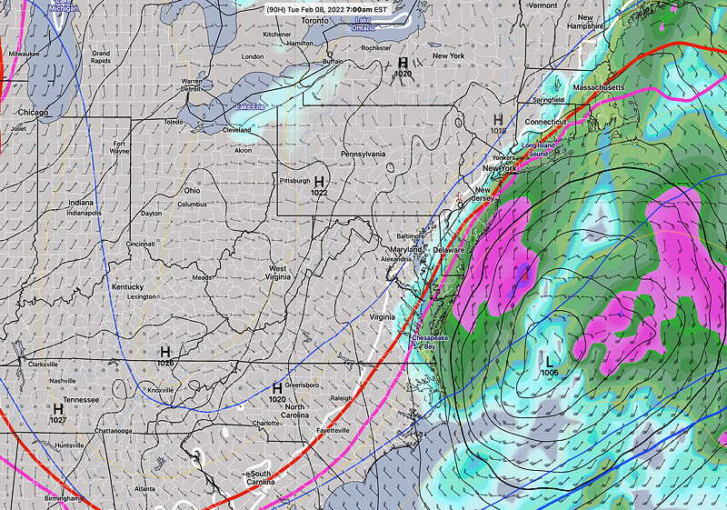
GEFS mode forecast 4 AM Tuesday (Click on image for a larger view.)
Cold high pressure will build in behind the rain that moved away almost on schedule as forecast. A straight forward forecast for the weekend.
Fair and very cold, with windy conditions, especially in the afternoon. High temperature 29.1º ± 0.9º. Wind chills will be in the teens. NBM model, Blue Bell.
Previously Posted Fri 7:52 PM —
Sunday
Sunny, occasional fair weather clouds. Much less windy. High temperature 33.0º ± 2.2º. NBM model, Blue Bell.
Looking Ahead…
Of interest is a low pressure system that will move off the coast Monday night into Tuesday morning. Most models have it missing us, possibly brushing the southern NJ shore with snow showers/flurries for us. I’ll keep an eye on it.
This afternoon’s ECMWF 18z forecast for Tues 7 AM (Click on image for a larger view.)

 GFS forecast with increasingly phased system Sunday