MAJOR CHANGE IN SNOW TOTAL FORECAST

Wed 09:51 AM Update — The most significant issue may be freezing rain, starting late afternoon.


I’ve been trying to ignore the NAM model forecasts in favor of the newer fancier models.  But when I go back to my forecasts that have really shined in past years, the temperature profiles of the NAM seem to be the most important factor, secondary to total QPF.

With the newest NAM model data just available, I can no longer ignore its forecast and its temperature profiles.

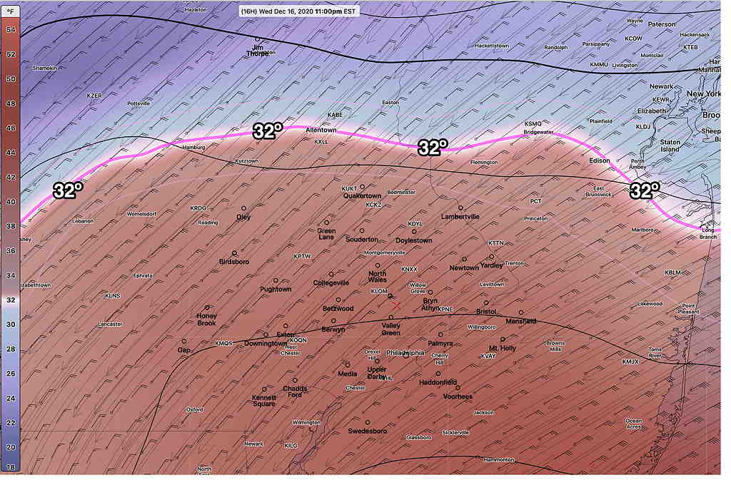
The NAM shows a large area of above freezing temperatures at 6000 feet resulting in much more sleet, freezing rain and rain than previously forecast—

Here’s the location of the 32º temperature at 6000 feet above ground at  11PM—

NAM 800 mb temperatures at 11 PM  (Click on image for a larger view.)

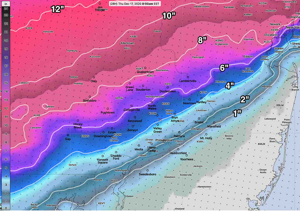
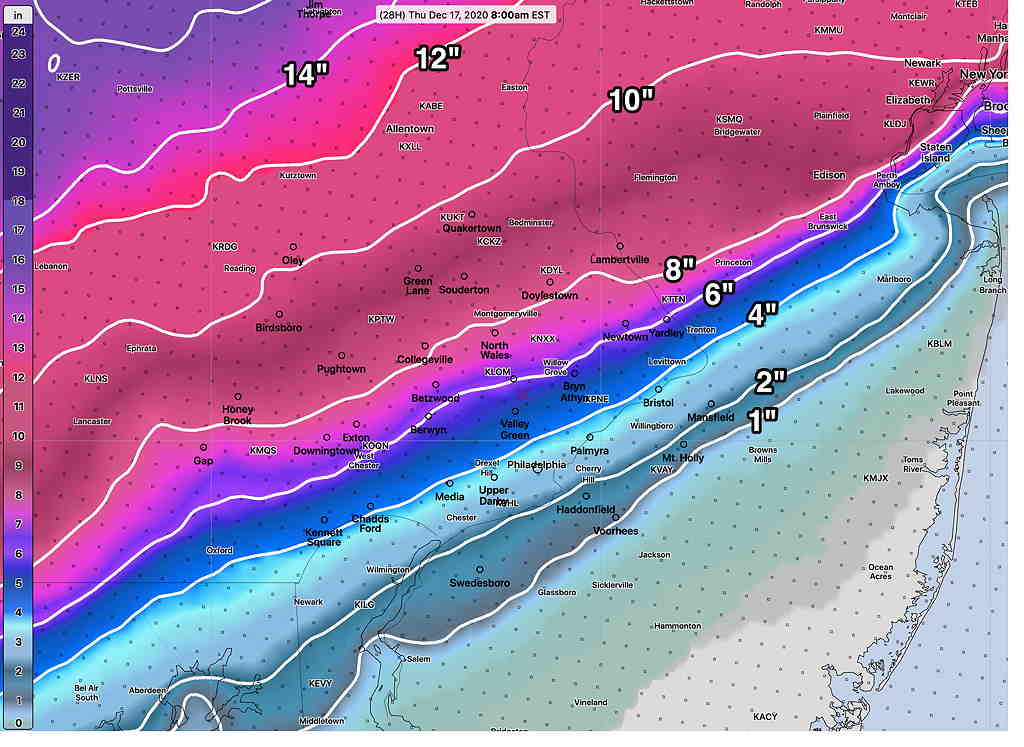
As a result, the NAM is predicting final snow totals on Thursday morning to be much lower than previously forecast—

NAM Snow Accumulation 7 AM Thursday  (Click on image for a larger view.)

The snow totals will only be 1-2 inches in the Philadelphia area and adjacent western suburbs by Thursday morning.

The start time for the snow is still about the same 12-2 PM, maybe 3PM. After snow accumulates by late afternoon a changeover to sleet and rain will seriously reduce additional snow totals. A change back to snow will occur before ending early Thursday morning around daybreak.

I know I’m going out on a limb with this forecast, but that’s the reason you’re reading this blog instead of watching the TV forecasts!

SNOWSTORM UPDATE

Last night’s models left us in two camps with different predictions about the amount of sleet and rain that will mix in this evening, with the effect of reducing total snow accumulations. 

As explained in yesterday’s post, while the “main” model runs are done at 00z and 12z, many models are re-run six hours later at 06z and 18z.  At this time of the morning, we have the 06z (1AM) model runs to see what trends have developed.

Here are the trends—

  • Snow starts between 12 and 2 PM today
  • Change-over to sleet and rain 6 PM- 11 PM
  • High gusty winds 40-50 mph this evening
  • Change back to snow after midnight
  • Snow ends 7-10 AM Thursday morning.

The NAM and NAM-NEST continue with significant sleet and less snow,  while several other models which had similar sleet forecasts (Canadian GDPS and RDPS) have more snow now.

At this point in the model cycle, the NBM (national model blend) 50 percentile forecast is the one to hang one’s hat on and the model’s statistical blend allows us to see the two different camps.

First, let’s look at the 25 Percentile—

The NBM 25 Percentile (meaning that only 25% of its model components have this forecast as its maximum snow depth—

NBM 25 Percentile Snow totals  (Click on image for a larger view.)


The NBM 50 Percentile (half of its models are above this value, half are below) is most representative of the current GFS, HRRR, CMC and ECMWF forecasts.

This is most likely total snow accumulations to expect

NBM Snow 24 hour accumulation 50 Percentile. (Click on image for a larger view.)


The above 50 percentile is the most likely snow totals to expect with this storm by Thursday morning. 

I’ll keep an eye on things. Stay tuned