WEEKEND WEATHER OUTLOOK

The stagnant, very mild pattern we’ve been in should continue, as I would describe the current overall situation as a “lack of very cold air” to our north.

Whatever blob of cold air exists in Canada will sag into the western/central US over the next few days, but  our area will still be on the relatively mild side of things. No very cold outbreaks in sight right now, although a weak front will bring in cooler temps for Sunday.

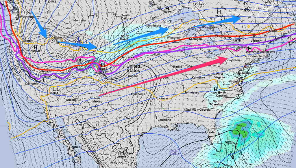
The Short Range Ensemble Forecast Model (SREF) sums it up well with the “540 thickness line”  (RED) staying north of our area—

SREF Model Sunday noon with “540 thickness line” (RED) and other upper air 0ºC lines (magenta, violet)    (Click on image for a larger view.)

Saturday—

As for the specifics for this weekend, a weak cold front will approach on Saturday about noontime, but upper air support is lacking and the front will fizzle out.   Showers with the front far west of the Philadelphia area are expected to reduce to some widely scattered sprinkles.

Speaking of  forecast specifics, it’s been difficult to predict when the low clouds level would lift each morning.  Over the past week, the higher resolution meso-scale models have been a bit too cloudy and the GFS has been useless, as it rarely showed the low clouds and fog that developed each early morning.  Saturday’s forecast is a bit different since clearing skies are expected during the afternoon after the frontal passage according to the model blend.  (Some models have slower clearing through the afternoon. ) Still mild with highs near 73º.

Sunday—

Sunny early.  High pressure moves off to our north and an easterly wind flow will bring in cooler temps and clouds late morning and cloudiness will increase during the afternoon.  Highs only 55º

Fri 03:36 PM Update — latest models have showers early evening Sunday.

Current seasonal average highs are 61º and average lows are 41º.


SUNDAY WEATHER UPDATE

The models overstated the cloudiness for this afternoon big time. A beautiful afternoon. I guess there was a good reason the NBM showed such high uncertainty.

While there had been uncertainty about the cloud forecast for this afternoon, the latest models show significant cloudiness this afternoon and the NAM-NEST, HIRESW and NBM show the possibility of scattered light sprinkles moving in about 2 PM from the east.


This morning’s low temperatures at 7 AM, based on the RTMA (Real Time Mesoscale Analysis)

RTMA  temperatures at 7 AM Sunday morning (Click on image for a larger view.)

In yesterday’s forecast, I mentioned the possibility of cloudiness for Sunday afternoon.   Several of the models have low cloudiness moving in on an easterly flow Sunday afternoon.

The model blend statistical treatment shows about 40% mean (average) cloudiness, but the standard deviation (a measure of the spread in the models or it can be interpreted as uncertainty) is as high 45-50%, especially west of Philadelphia  Sunday afternoon by 3 PM.

NBM Cloudiness Standard deviation at 3 PM (Click on image for a larger view.)


The high resolution NAM-NEST shows low level cloudiness moving in, with a mix of high and middle level clouds further to our west—

NAM NEST cloud forecast (high, medium, low clouds) for 3 PM Sunday.   Low level clouds are in blue. (Click on image for a larger view.)

So, there’s uncertainty in the degree of cloudiness for Sunday afternoon, but I’m thinking it might be significant by 3 PM.

High temp Sunday 63.7º with a high confidence of 0.8º standard deviation. (The standard deviation can be thought of as 67% of the time, the temperature will fall with ± 0.8º of the mean temp 63.7º)