WEEKEND WEATHER FORECAST

[su_box title=”Forecast Update Sun AM” box_color=”#defcdc” title_color=”#000000″]The forecast from Friday remains on track. High temperature 57-59. Clouds move in during the afternoon.

Winds 5-10 mph W->WSW, increasing later in the afternoon::
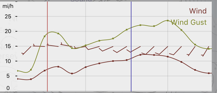
HRRR forecast -Fort Washington gridpoint

[/su_box]

[su_box title=”Forecast Update Sat AM” box_color=”#defcdc” title_color=”#000000″]Very windy, as expected, today. NBM model wind forecast for our area Saturday (in red box)
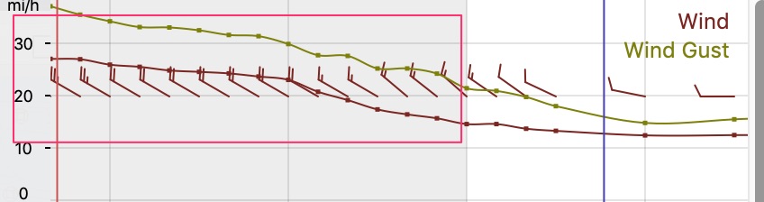
[/su_box]

The deep low pressure system that brought us heavy rain Thursday into early Friday will move away while it deepens.  A cyclonic flow of colder air will move in for Saturday.

Saturday will be mostly sunny, windy and somewhat chilly.  High 48.  The models don’t show any instability cloudiness, although I’m curious to see if any develops in the cyclonic flow.

Sunday will start sunny.  A low pressure system approaching from the Midwest will bring some cloudiness in during the afternoon hours.  High 56-58.

The low pressure system and another cold front moves through late Monday with rain.  Temperatures drop later Monday night.  While there was some thought that there might be some snowflakes mixing in as the precipitation ends, the models, including the FV3-GFS, don’t seem to support that scenario now.

WEATHER OUTLOOK- WEDNESDAY

Some interesting observations about upcoming weather for the Philadelphia area—

  • The rain now expected Thursday into Friday morning was not really picked up by the models until two days ago.  The exception was the new FV3-GFS, which predicted the coastal storm almost two days before the other models jumped on board.  (The ‘exclusive forecast’ from one of the TV stations was predicting a full week of dry weather just last weekend.)
  • This upcoming weekend, especially Friday through Saturday, will be anything but Spring-like.  Windy conditions and unseasonably cold temperatures are expected, especially on Saturday.
  • The FV3-GFS is predicting a very cold outbreak Monday night into Wednesday next week.  Included is a possible changeover from rain to snow late Monday into Monday evening.  Maybe an outlier of a forecast, but something to watch, considering the model’s success this week.

WEEKEND WEATHER FORECAST

[su_note note_color=”#d9f2da”]Update Saturday morning. The short range models show signficantly less stratocumulus cloudiness than the NAM. I guess we’ll see.[/su_note]

Following a cold front Friday evening, high pressure will build in for Saturday and Sunday.

After today’s very warm temperatures, Saturday and Sunday will be much chillier.  Winds and some clouds on Saturday will make the day feel even colder.

Saturday will start sunny, but cold air aloft will result in a considerable amount of instability stratocumulus cloudiness at times, especially late morning and early afternoon.    It will be windy and gusty. High 46-48.

Stratocumulus cloud overage expected for Saturday (NAM NEST) (darker shades–> more clouds)

Sunday will be sunny with light winds.  Temperatures will still be below average, with a high of 45.

Average high temps are about 54ºF for Philadelphia.